August 21 , 2025.
Italy / Sicily , Etna :
Etna Activity Statement, August 20, 2025, 11:53 (09:53 UTC)
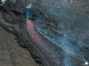
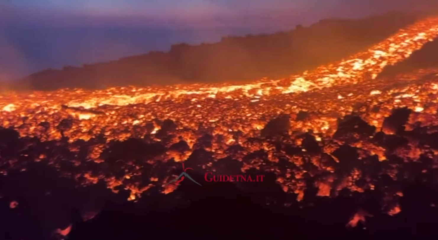
The National Institute of Geophysics and Volcanology, Osservatorio Etneo, announces that volcanological observations carried out by INGV personnel in the field, as well as images acquired by the video surveillance network, indicate that the lava flow emitted by the effusive vent at an altitude of 2,980 m is still being fed. The effusive vent feeds a collapsed lava field in its proximal part, while in its distal part, it divides into three main branches progressing southwestward, with the flows overlapping. The most advanced front is located at an altitude of approximately 2,300 m, upstream of the Grotta degli Archi. Strombolian activity continues in the Southeast Crater with variable intensity and the formation of sporadic emissions of volcanic ash that disperse rapidly into the atmosphere. The average amplitude of volcanic tremors remains high, despite strong fluctuations, and shows an increasing trend. The center of gravity of the tremor sources is located in the Southeast Crater area, at a depth of approximately 3,000 meters above mean sea level. Infrasound activity has shown a moderate increase in the occurrence rate of events, which appear to be localized in the Southeast Crater and characterized by a medium amplitude.
The deformation signals recorded by the GNSS and inclinometer networks currently show no significant variation. Since the beginning of the current effusive activity, the DRUV dilatometer station has shown an overall variation in decompression of approximately 10 nstrain.
Statement on Etna activity, August 20, 2025, 12:33 PM (10:33 UTC)
The National Institute of Geophysics and Volcanology, Osservatorio Etneo, announces that, according to high-altitude volcanological observations carried out by INGV personnel, the opening of a new effusive vent has been observed at an altitude of approximately 3,100 m above sea level, at the base of the saddle between the Bocca Nuova crater and the Southeast crater. This vent is producing low-level spatter activity and a small lava flow directed southward. Effusive activity from the vent located at an altitude of 2,980 m continues as described in the previous press release.
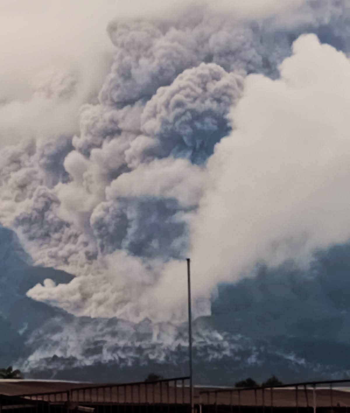
Etna Activity Update, August 20, 2025, 6:42 PM (16:42 UTC)
The Etna Observatory, National Institute of Geophysics and Volcanology, announces that, according to volcanological observations made by INGV staff at the summit and images acquired by the video surveillance network, a new effusive vent has opened since approximately 13:40 UTC on the southern flank of the Southeast Crater, at an altitude of approximately 3,200 m, feeding a lava flow that is spreading southwestward. Effusive activity from two vents located at an altitude of approximately 3,100 m and 2,980 m, as reported in previous press releases, continues.
Strombolian activity continues in the Southeast Crater, accompanied by volcanic ash emissions that disperse rapidly into the atmosphere. Since the last update at 11:53 local time, no significant changes have been reported regarding the amplitude of the volcanic tremors or the location of their sources. The average amplitude fluctuates in the high frequencies, and the centroid of the sources is located in the Southeast Crater area, at a depth of about 3,000 meters above mean sea level. Infrasound activity has decreased, and the rare localized events are located in the Southeast Crater. Deformation signals recorded by the GNSS network currently show no significant changes. As of about 13:00 UTC, the inclinometer station at the Piano Crater indicates a slight variation of about one microradian, consistent with ongoing eruptive activity. The DRUV dilatometer station continues to show slight variations in decompression.
Further updates will be provided shortly.
Source : INGV
Photos : CMS-OVD , Guide Alpine Vulcanologiche Etna ( capture d’écran).
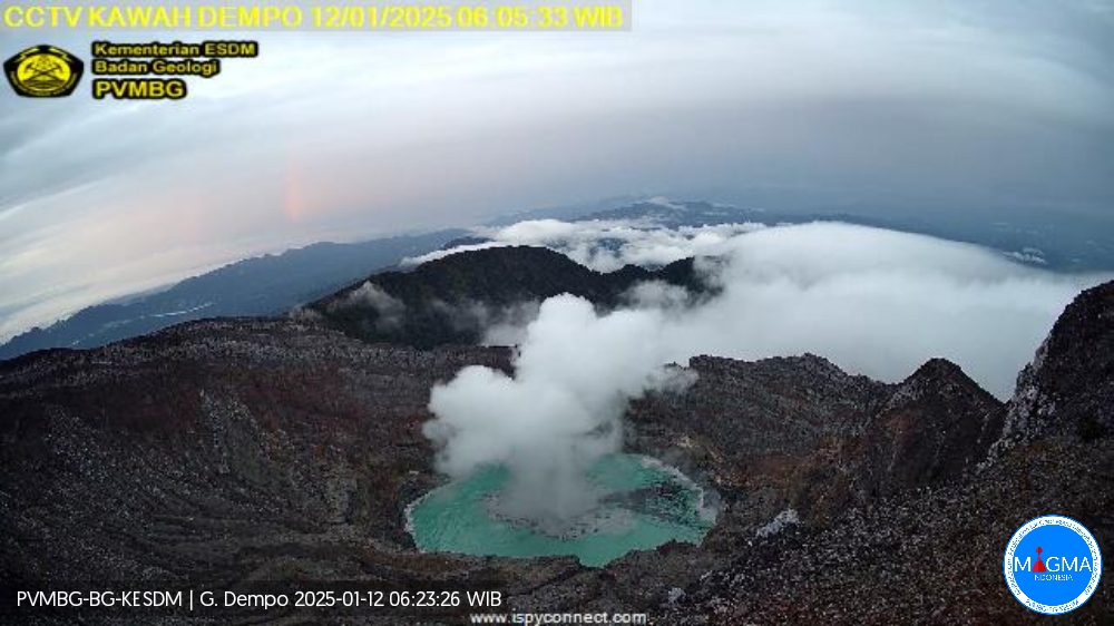
Indonesia , Dempo :
Dempo Volcano Eruption, South Sumatra, August 19, 2025, 7:48 AM WIB
Dempo Volcano is an active volcano located in South Sumatra Province. This stratovolcano rises to an altitude of 3,173 meters. Volcanic activity is currently concentrated in the Marapi Crater.
Mount Dempo erupted on August 19, 2025, at 7:48 AM WIB, producing a thick, white, south-leaning eruptive column, reaching approximately 1,300 meters above the summit (or approximately 4,473 meters above sea level). This eruption was recorded on a seismogram with a maximum amplitude of 30 mm and a duration of approximately 1 minute and 52 seconds.
The Geological Agency issued a special report regarding an increase in deep volcanic earthquakes on Mount Dempo on July 10, 2025. On August 7, 2025, at 9:38 p.m. WIB, an eruption occurred, with the eruptive column reaching 1,200 m above the summit. As of the date of this special report, monitoring data indicate sustained and intense volcanic activity.
Seismic monitoring for the period from August 1 to 18, 2025, recorded:
1 eruption earthquake,
2 avalanche earthquakes,
40 emission earthquakes,
8 low-frequency earthquakes,
9 shallow volcanic earthquakes,
4 deep volcanic earthquakes,
5 local tectonic earthquakes,
2 felt earthquakes on the IMT scale I to II,
10 distant tectonic earthquakes,
Continuous tremors with amplitudes ranging from 0.5 to 10 mm, mainly 5 mm.
Observations of the deformation of Mount Dempo by GNSS and tiltmeter over a one-week period indicate an inflationary trend in the western sector of the volcano. This indicates that significant pressure sources persist at shallow depths.
Visual monitoring of Mount Dempo from August 1 to 18, 2025, showed that the volcano was clearly visible until it was obscured by fog. No smoke was observed in the crater. An eruption occurred, with a gray eruptive column reaching 1,200 meters from the summit. Avalanches were observed, with a sliding distance of 30 to 50 meters in the crater and an easterly sliding direction.
Eruptions at Mount Dempo are characterized by phreatic eruptions, which can occur suddenly without obvious volcanic symptoms. Based on analysis of visual and instrumental data, Mount Dempo’s activity level remains at Level II (waspada). The public, visitors and tourists are advised not to approach or spend the night near the center of activity, namely the Marapi crater, within a radius of 1 km and 2 km towards the crater opening to the north, due to the risk of ejection due to phreatic eruptions and the potential presence of volcanic gases dangerous to life.
Source et photo : PVMBG
Kamchatka , Krasheninnikov :
The Kamchatkan Volcanic Eruption Response Team (KVERT) and reported that the eruption at Krasheninnikov continued during 12-19 August. A large bright thermal anomaly over the volcano was identified in satellite images on most days; weather clouds obscured views on 17 August. Ash plumes from explosions at the northern cone drifted as far as 170 km E and SE on 13 August. Explosions on 14 August generated ash plumes that reached 2-3 km a.s.l. and drifted 170 km SE based on satellite data. Branching lava flows on the NW flank were active at least through 15 August. The Aviation Color Code remained at Orange (the second highest level on a four-color scale). Dates and times are provided in Coordinated Universal Time (UTC); specific events are indicated in local time where specified.
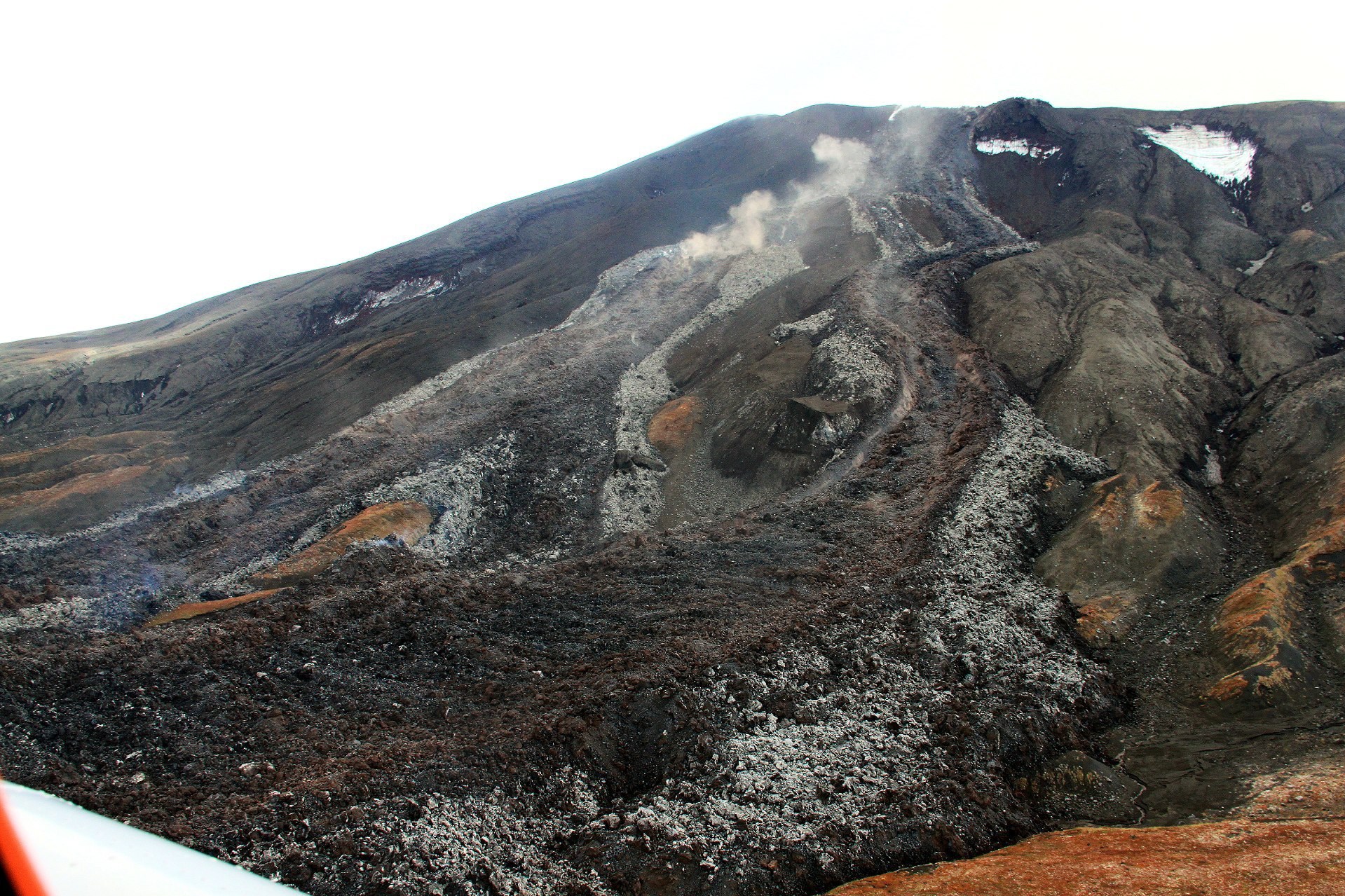
The late-Pleistocene to Holocene Krasheninnikov volcano is comprised of two overlapping stratovolcanoes within a 9 x 10 km Pleistocene caldera. Young lava flows from summit and flank vents descend both into the caldera and down its outer flanks, and older flows that covered much of the SE caldera rim extended downslope at least 7 km. Tephra deposits from the caldera-forming eruption directly overlie a 39,000 years before present (BP) tephra thought to be associated with the formation of Uzon caldera (Florenskii, 1988). The intra-caldera stratovolcanoes are situated along a NE-SW-trending fissure that has also produced zones of Holocene cinder cones extending 15-20 km beyond the caldera. Construction of the southern edifice began about 11,000 years BP and lasted for about 4,500 years; it has a summit crater about 800-900 m wide. The northern edifice was constructed during a cycle of similar length that began about 6,500 years ago; it has a summit crater about 1.5 km wide, within which is low cone with an 800-m-wide crater containing another small cone. An eruptive cycle during about 600-400 years BP (1350-1550 CE) produced the Pauk lava cone in the crater of the northern cone and the Yuzhny lava flow on SW flank outside the caldera, followed by the Molodoy flow from the upper SW flank (Ponomareva, 1987; Ponomareva and Tsyurupa, 1985; Ponomareva and Braitseva, 1990).
Sources: Kamchatkan Volcanic Eruption Response Team (KVERT), GVP.
Photo : via Vulcaniya /FB
Japan , Shinmoedake :
The Japan Meteorological Agency (JMA) reported that eruptive activity continued at Shinmoedake (Shinmoe peak, a stratovolcano of the Kirishimayama volcano group) during 11-18 August. The number of volcanic earthquakes located beneath Shinmoedake, first detected in late October 2024, continued to be frequent; volcanic tremor was also occasionally detected, notably during eruptive events. Sulfur dioxide emissions on 12 August were characterized as high, averaging 1,000 tons per day. Ash plumes were continuously emitted during 01h00-16h50 on 13 August rising as high as 500 m above the crater rim and drifting N and NW. At 10h50 and 14h22 on 15 August ash plumes rose 300 m above the crater rim into weather clouds. The Alert Level remained at 3 (on a 5-level scale) and the public was warned to exercise caution within 3 km from Shinmoedake Crater.
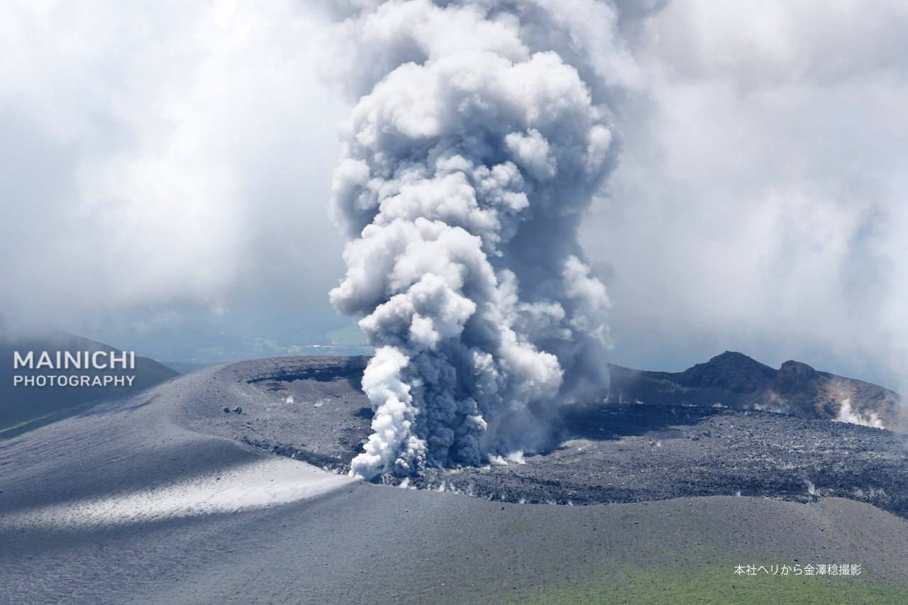
Kirishimayama is a large group of more than 20 Quaternary volcanoes located north of Kagoshima Bay. The late-Pleistocene to Holocene dominantly andesitic group consists of stratovolcanoes, pyroclastic cones, maars, and underlying shield volcanoes located over an area of 20 x 30 km. The larger stratovolcanoes are scattered throughout the field, with the centrally located Karakunidake being the highest. Onamiike and Miike, the two largest maars, are located SW of Karakunidake and at its far eastern end, respectively. Holocene eruptions have been concentrated along an E-W line of vents from Miike to Ohachi, and at Shinmoedake to the NE. Frequent small-to-moderate explosive eruptions have been recorded since the 8th century.
Sources: Japan Meteorological Agency (JMA) , GVP.
Photo : Mainichi via Alex Terry / FB. (archive)
Guatemala , Santiaguito :
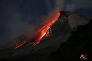
The Instituto Nacional de Sismología, Vulcanología, Meteorología e Hidrología (INSIVUMEH) reported high levels of ongoing eruptive activity at Santa Maria’s Santiaguito dome complex during 12-19 August, with continuing lava extrusion at Caliente dome. Daily explosions, 1-2 per hour when reported, generated gas-and-ash plumes that rose 800-900 m above the dome and drifted W and SW. Effusion of blocky lava and collapses of previous deposits produced block avalanches that descended mainly the W and SW flanks; the collapsed material produced short pyroclastic flows that descended the SW and S flanks during 12-13 August. Incandescence during dark hours was visible from Caliente dome and block avalanches. During the early afternoon of 12 August heavy rainfall generated lahars in the Tambor drainage (SSW) that carried blocks up to 1 m in diameter mixed with fine sediment, tree trunks, and branches. The lahars were hot and had a sulfur odor.
Material accumulated at the W crater rim began collapsing at 16h30 on 16 August, generating pyroclastic flows that descended the San Isidro drainage as far as 4 km. Associated gas-and-ash plumes rose 1 km and drifted 30-60 km W and SW, causing abundant ashfall in San Marcos Palajunoj (8 km SW), Loma Linda (7 km W), San Martín Sacatepéquez (11 km NW), and Colomba (18 km WSW) and minor ashfall in more distance areas including La Reforma (28 km WNW), El Quetzal (26 km WNW), Coatepeque (31 km W), and Pajapita (50 km W). In the early evening of 16 August minor lahars descended the Zanjón Seco (SW) and Tambor River channels.
Sources : Instituto Nacional de Sismologia, Vulcanologia, Meteorologia, e Hidrologia (INSIVUMEH) , GVP
Photo : Sismologie Nacional de Guatemala / FB.