July 27 , 2025.
Hawaii , Kilauea :
HAWAIIAN VOLCANO OBSERVATORY DAILY UPDATE , U.S. Geological Survey.
Saturday, July 26, 2025, 8:59 AM HST (Saturday, July 26, 2025, 18:59 UTC)
19°25’16 » N 155°17’13 » W,
Summit Elevation 4091 ft (1247 m)
Current Volcano Alert Level: WATCH
Current Aviation Color Code: ORANGE
Activity Summary:
The ongoing Halemaʻumaʻu eruption is currently paused. Episode 29 ended on July 20, 2025, after over 13 hours of sustained lava fountaining. Summit inflation resumed immediately and continues today. Degassing and low-level seismic tremor also persist. Based on current rates of inflation, the next episode may occur in approximately 4-8 days.
No significant activity has been noted along Kīlauea’s East Rift Zone or Southwest Rift Zone.

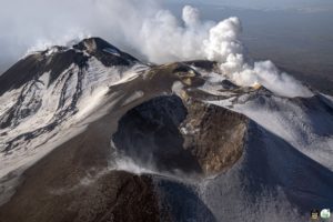
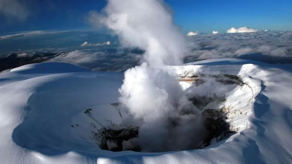
This oblique aerial view of the tephra cone from the ongoing Kīlauea summit eruption was captured during a USGS Hawaiian Volcano Observatory UAS (uncrewed aircraft systems) flight on July 25, 2025. The aircraft was flying about 120 m (400 ft) above ground level, with the image captured looking to the northeast. The featureless expanse spanning most of the image frame consists of tephra ejected from the eruptive vents (right background, within Halema‘uma‘u crater), with tire tracks in the foreground marking routes that scientists have been using to access monitoring equipment in the area.
Summit Observations:
Incandescence in the crater has been limited the past two nights, with little-to-no glow from north vent and intermittent glow from two areas higher up on the eruptive cone. Lava flows on the floor of Halemaʻumaʻu may continue to exhibit slow movement or sporadic incandescence as they cool and solidify over the coming days. Slow slumping of the eruptive cone is also possible.
At present, low-level tremor and elevated degassing persist. Seismic and gas data streams indicate that gas pistoning is occurring; however, no lava or spatter is visible at the surface in association with the pistons at this time. Typical average sulfur dioxide (SO2) emission rates during inter-episode pauses are 1,200 to 1,500 t/d, though emission rates vary on short time scales in association with gas pistoning.
Fountaining associated with Episode 29 resulted in approximately 19 microradians of deflation. At the time of this update, UWD had re-inflated by about 10.0 microradians.
Source : HVO.
Photo : USGS / A. Kekahuna / M. Zoeller.
Indonesia , Dukono :
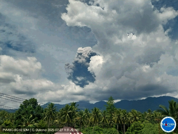
Mount Dukono erupted on Sunday, July 27, 2025, at 11:19 a.m. (local time). An ash column was observed about 3,000 m above the summit (about 4,087 m above sea level). The ash column was white to gray in color, with a thick plume extending northward. At the time of writing, the eruption was still ongoing.
Seismic Observations
185 eruption earthquakes with amplitudes ranging from 6 to 34 mm and durations ranging from 33.17 to 191.63 seconds.
One felt earthquake, on the MMI II scale, with an amplitude of 34 mm, no observed magnitude, and a duration of 244.54 seconds.
One distant tectonic earthquake with an amplitude of 34 mm and a duration of 141.55 seconds.
Recommendations
Residents near Mount Dukono and visitors/tourists are advised to avoid any activity, climbing, or approaching the Malupang Warirang crater within a 4 km radius.
Since volcanic ash eruptions occur periodically and the distribution of ash is influenced by wind direction and speed, making the ash impact area unstable, residents around Mount Dukono are advised to always have masks/nose and mouth coverings available for use when needed to avoid the dangers of volcanic ash on the respiratory system.
Source et photo : Magma Indonésie .
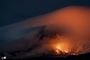
Colombia , Nevado del Ruiz :
Manizales, July 22, 2025, 6:30 a.m.
Regarding the monitoring of the activity of the Nevado del Ruiz volcano, the Colombian Geological Survey (SGC), an entity affiliated with the Ministry of Mines and Energy, reports that:
During the week of July 15-21, 2025, the volcano continued to exhibit unstable behavior. Compared to the previous week, the main variations in the monitored parameters were:
– Seismicity related to fluid dynamics in the volcanic conduits decreased slightly (number of recorded earthquakes) and increased (seismic energy released). The energy levels of these signals ranged from low to moderate.
Despite the heavy cloud cover in the area, which limited observation of the gas or ash column, the cameras (conventional or thermographic) used to monitor the volcano confirmed several pulsed ash emissions associated with these signals. Similarly, variations in the apparent temperature of the emitted material were detected, linked to some of the recorded ash emissions. In addition, observation reports of the ash emission recorded on July 19 at 5:38 p.m. were obtained from photographs taken by passengers on a commercial flight and by SGC personnel conducting fieldwork in the area.
– Seismic activity associated with rock fracturing processes within the volcanic edifice has led to a decrease in the number of recorded earthquakes and an increase in the seismic energy released. Most of the earthquakes occurred in the Arenas Crater, at depths ranging from less than 1 km to 2 km from the volcano’s summit. In addition, a small number of scattered earthquakes were recorded on different flanks (northeast, south-southwest, southeast, north, and northwest), up to 12 km from the crater, at depths ranging from 2 km to 6 km. The highest magnitude of the week was 1.8, corresponding to the earthquake recorded on July 21 at 3:27 a.m., located in the crater at a depth of 1.5 km.
– Water vapor and gas emissions, mainly sulfur dioxide (SO₂), from the Arenas Crater into the atmosphere were variable. Estimated daily SO₂ flux values associated with degassing decreased compared to the previous week. Satellite monitoring, currently underway to assess this parameter, showed low SO₂ releases, partly due to the high cloud cover in the area, which limited the detection of this gas.
– The vertical height of the gas or ash column generally remained below 400 m, measured above the volcanic summit. However, during the ash emissions recorded on July 18 at 4:36 PM, between 10:38 PM on July 19 and 12:45 PM on July 20, vertical heights exceeding 1,000 m were observed, and dispersion heights of up to 2,400 m were observed, the latter value having been recorded during the July 20 event.
– The direction of gas or ash column dispersion showed a preferential trend toward the northwest and west-northwest flanks of the volcano throughout the week. This situation favored ashfall in the municipalities of Manizales and Chinchiná (Caldas department), associated with the aforementioned events of July 18 and 19.
– No thermal anomalies were reported at the floor of the Arenas crater during satellite monitoring, due to atmospheric conditions unfavorable for their detection.
Source et photo : SGC.
Costa Rica , Poas :
Latitude: 10.2
Longitude: -84.233
Altitude: 2,687 m
Observed Activity:
No eruption or ash emission has been recorded in the last 24 hours. Seismographs and infrasound sensors are recording continuous signals of volcanic and acoustic tremor of relatively low and stable amplitudes. The SENTINEL satellite detected up to 37 tons of SO2 released by Poás between July 20 and 24. For comparison, on April 26, the amount of SO2 detected was 2,263 tons. Water vapor and magmatic gases, as well as heat, continue to be released at a high rate from the crater floor, mainly through the Boca A and Boca C vents.
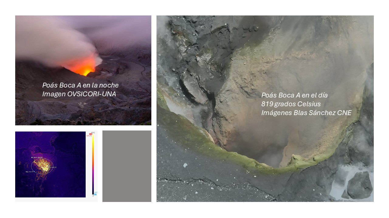
Boca A continues to glow, particularly visible at night. Yesterday, July 24, the National Emergency Commission (CNE) remotely measured, using an infrared thermal imaging camera attached to a drone, a maximum temperature of 819°C (1,810°F) at Boca A and between 74 and 87°C (165 and 187°F) in the newly forming hyperacid lake at Boca C (Blas Sánchez CNE, direct communication). The rim and interior of Boca A contain pinkish-yellow rock material, heavily chemically altered by very hot, oxidizing magmatic gases.
Environmental Conditions:
At the summit of Poás, the wind is blowing southwest at 19.9 km/h (IMN) and the sky is cloudy.
Activity Level: Warning (2)
Source et photo : Ovsicori
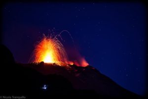
Ecuador , El Reventador :
DAILY STATUS REPORT OF REVENTADOR VOLCANO, Saturday, July 26, 2025.
Information Geophysical Institute – EPN.
Surface Activity Level: High, Surface Trend: No change
Internal Activity Level: Moderate, Internal Trend: No change
From July 25, 2025, 11:00 a.m. to July 26, 2025, 11:00 a.m.:
Seismicity:
Below is the count of seismic events recorded at the reference station.
Explosion (EXP) 87
Long Period (LP) 17
Emission Tremor (TREMI) 10
Harmonic Tremor (TRARM) 8
Rainfall/Lahars:
No rainfall has been recorded in the volcano area. **Heavy rainfall could remobilize accumulated material, generating mud and debris flows that would cascade down the volcano’s flanks and flow into adjacent rivers.**
Emissions/Ash Plume:
Since yesterday afternoon, surveillance cameras and satellite images have recorded several gas and ash emissions, between 800 and 1,100 meters above the crater level, in east-southeast, west-northwest, and west directions. Regarding this activity, the Venezuelan Air and Space Administration (VAAC) in Washington has released two reports indicating emissions reaching up to 1,000 meters above the crater level, in west and northwest directions.
Other monitoring parameters:
Over the past 24 hours, the FIRMS satellite system recorded two thermal anomalies, and the MIROVA-VIIRS 750 satellite system recorded three.
Observation:
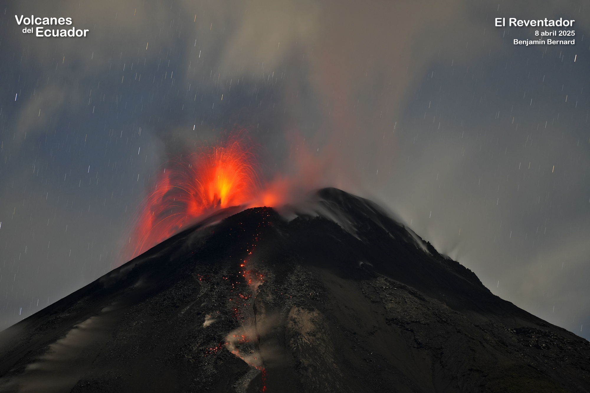
Yesterday afternoon and early this morning, several episodes of incandescent material falling on the volcano’s flanks were recorded, reaching 1,000 meters below the crater level.
At the time of writing, the volcano remains cloudy.
Alert Level – SGR: Orange
Source : IGEPN
Photo : Benjamin Bernard , Volcanes del Ecuador , 2/11/2024