July 22 , 2025.
Iceland : Reykjanes Peninsula :
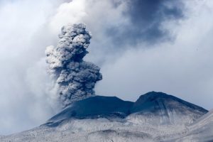
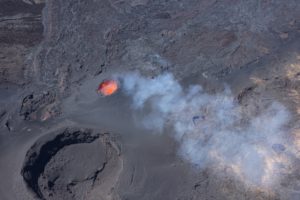
Eruption in the Sundhnúk Crater Series – Air Pollution, Smog, and Advice
Continued activity during the eruption – two craters continue to erupt in the middle of the fissure
Lava continues to flow eastward at Fagradalur
Little or no seismic activity in the magma chamber
High levels of gaseous pollution (SO₂) due to the eruption have been measured in the capital region and Akranes since this morning. The pollution appears to have decreased, but it still appears as a blue haze over the city.
The eruption has caused significant air pollution in recent days, due to both gaseous pollution (SO₂) and smog.
What is smog?
Smog forms when sulfur dioxide (SO₂) reacts with moisture and oxygen in the atmosphere to form fine particles of sulfate and sulfuric acid. It can travel long distances and linger over homes for a long time; it is not visible as SO₂ on air meters.
Measurements of fine particles (PM1 and PM2.5) provide an indication of smog, but do not measure it accurately. Yesterday, SO₂ measurements were low, despite the presence of smog over the city.
Today, actual gas pollution (SO₂) was measured.
The Icelandic Meteorological Office’s gas distribution forecast only covers SO₂ and does not predict smog distribution.
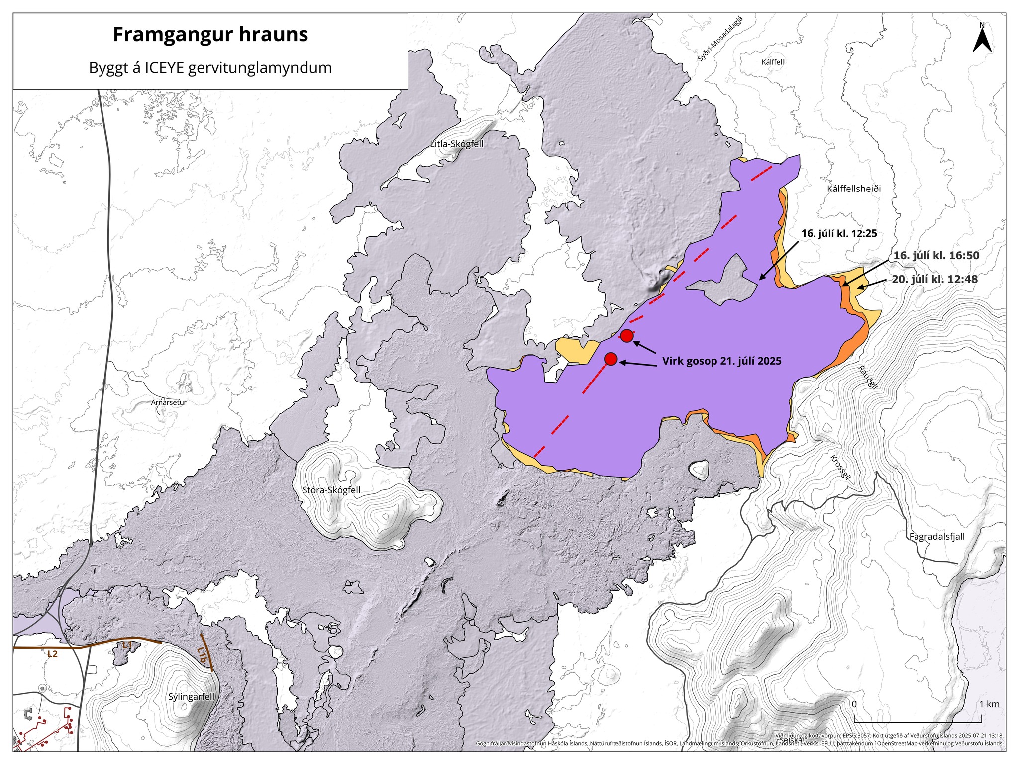
The map shows the changing contour of the new lava flow that occurred between July 16 and noon yesterday, July 20. These contours are based on ICEYE satellite images. Most of the lava erupted during this eruption flowed southeast toward Fagradalsfjall. The lava then slowly filled the depressions and valleys along the foothills of Fagradalsfjall, to the north and south. The maps also show the fissures that appeared during the eruption. Activity is now limited to two vents, also marked on the map.
Source : IMO
Photos : Jakes on a plane via FB, IMO.
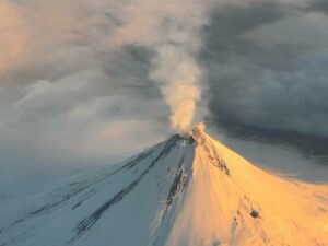
New Zealand , Ruapehu :
Possible end of cooling episode at Te Wai ā-moe (Ruapehu Crater Lake). The Volcanic Alert Level remains at 1.
Published: Tue Jul 22 2025 10:00 AM
Since last week’s update, Te Wai ā-moe (Ruapehu Crater Lake) seems to have stopped cooling, with daily temperatures remaining at around 11°C. Sulphur dioxide gas emissions rose briefly to 800 tonnes per day (t/day) before declining again to ~200 t/day, and a swarm of very small earthquakes occurred beneath the volcano, although these were too small to be precisely located. Together, these minor changes suggest that a new heating episode could be starting at the crater lake.
No other unusual changes have been observed, and the Volcanic Alert Level remains at 1 and the Aviation Colour Code at Green.
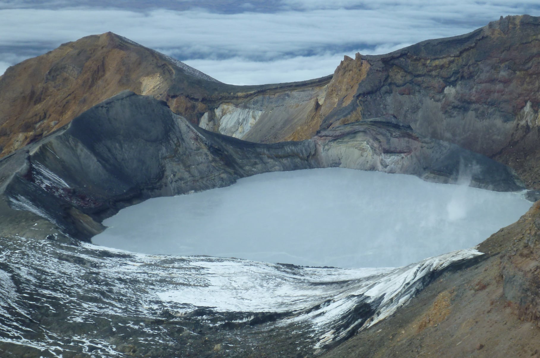
Episodes of renewed heating beneath Ruapehu are typically preceded by local earthquakes and signs of heat and gas flowing upwards into the volcano. Clusters of very small earthquakes were detected by some of the seismometers on Ruapehu, but their exact locations and depth could not be determined. There is no evidence they are directly related to the swarm of earthquakes that occurred two weeks ago 10 km east of Ruapehu. Volcanic tremor, a key indicator of volcanic fluid movement, did not notably change and remains weak. During the past month, the temperature of Ruapehu’s Crater Lake has stopped declining and remained steady around ~10 to 12 ºC which is low but still indicates a continuous low level heat input.
Last week’s pulse of volcanic sulphur gas measured by our continuous gas emission detectors shows that the top of the volcano is not sealed, and a lack of other observed changes at Ruapehu indicates that the volcano continues to exhibit typical low levels of activity.
In summary our recent observations are consistent with minor volcanic unrest, therefore, the Volcanic Alert Level remains at 1 and the Aviation Colour Code remains Green.
Source : Geonet / Michael Rosenberg / Earth Sciences NZ Duty Volcanologist
Photo : Geonet
Indonesia , Dukono :
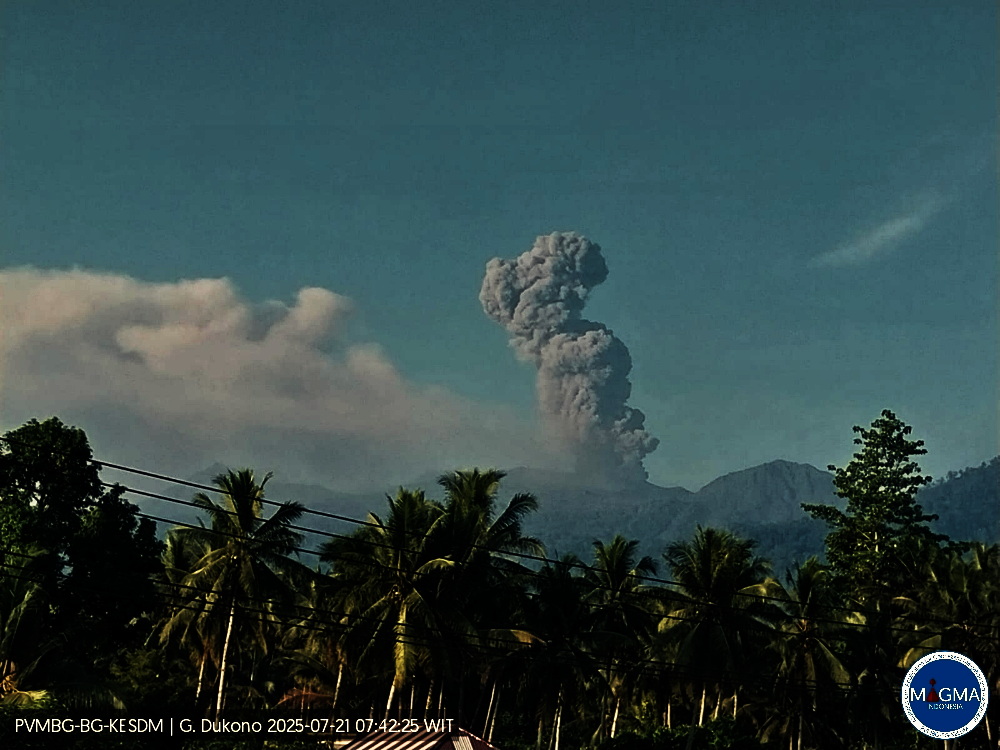
Mount Dukono erupted on Monday, July 21, 2025, at 7:20 a.m. (local time). An ash column was observed about 1,200 m above the summit (about 2,287 m above sea level). The ash column was white to gray in color, with strong intensity, moving eastward. At the time of writing, the eruption was still ongoing.
Seismic Observations
212 eruption earthquakes with amplitudes ranging from 7 to 27 mm and durations ranging from 30:09 to 410:66 seconds.
2 distant tectonic earthquakes with amplitudes ranging from 4 to 5 mm and durations ranging from 61:57 to 70:75 seconds.
1 continuous tremor with amplitudes ranging from 2 to 4 mm, mainly 2 mm.
Recommendations
(1) People living around Mount Dukono and visitors/tourists are advised to avoid all activity, climbing, and approaching the Malupang Warirang crater within a 4 km radius. (2) Since volcanic ash eruptions occur periodically and the distribution of ash follows the direction and speed of the wind, making the ash coverage area unstable, it is recommended that communities around Mount Dukono always have masks/nose and mouth covers available for use when needed to avoid the dangers of volcanic ash on the respiratory system.
Source et photo : Magma Indonésie .
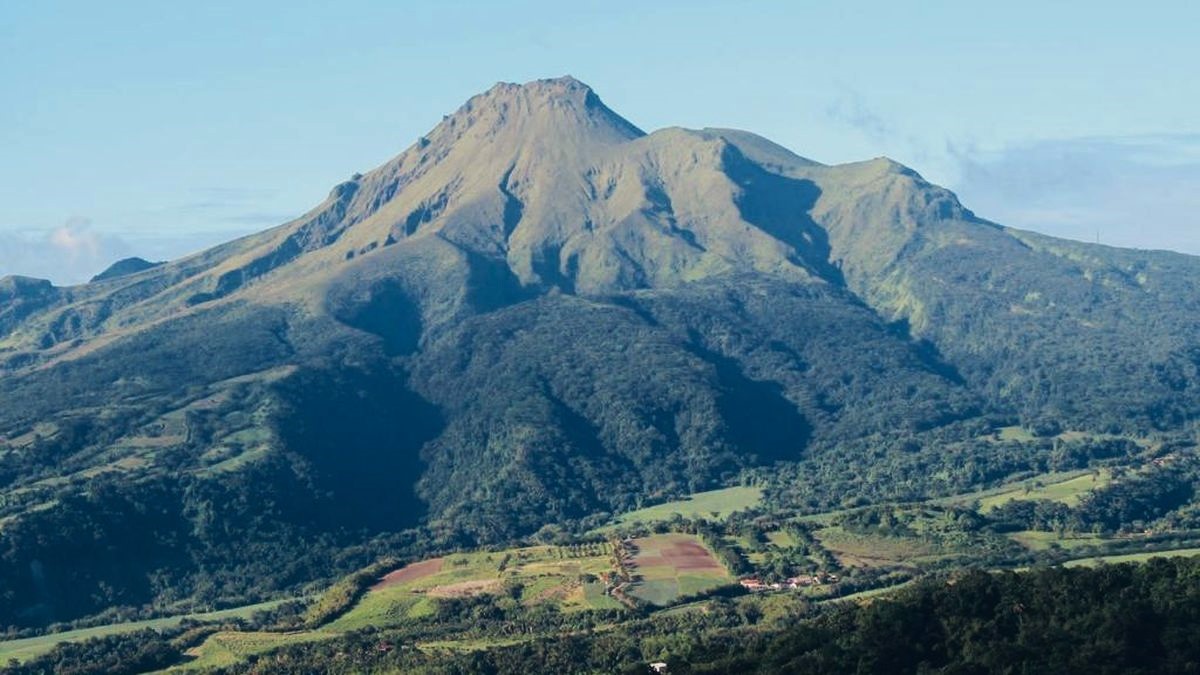
Costa Rica , Poas :
OVSICORI-UNA Weekly Volcano Monitoring Bulletin, July 18, 2025
Latitude: 10.20°N;
Longitude: 84.23°W;
Altitude: 2,687 m
Current Activity Level: Caution
Following the eruption on May 19, no explosive events were recorded.
This week, the amplitudes of the continuous seismic tremor and acoustic tremor at Vent A decreased compared to previous weeks. The number of long-period events increased compared to last week. No volcano-tectonic events were recorded this week.
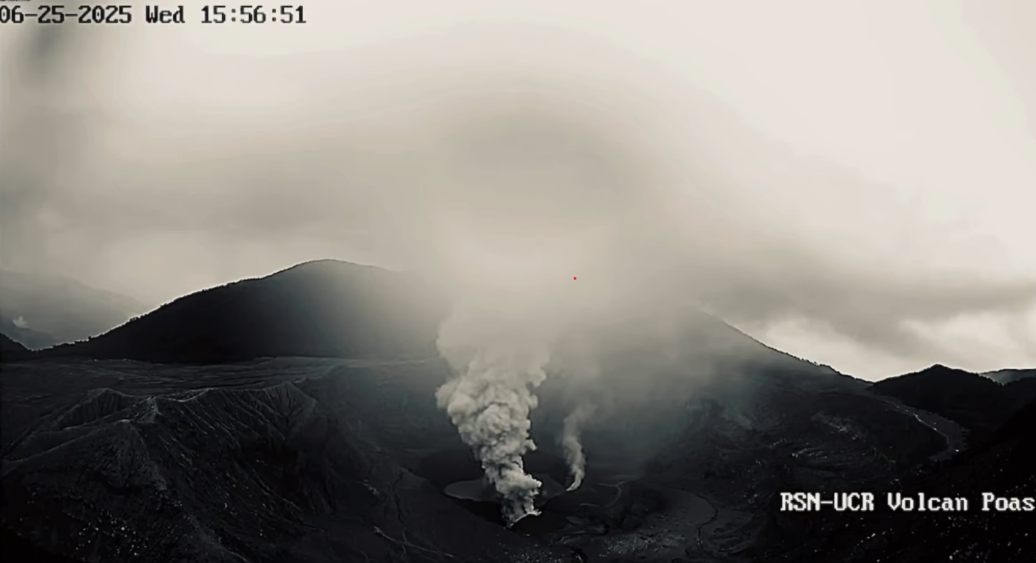
The average SO2 flux increased this week (605 ± 31 t/d) compared to the previous week (520 ± 46 t/d). The amount of SO2 emitted by the Poás, measured in the Costa Rican atmosphere by the TROPOMI sensor on the Sentinel-5P satellite, shows a significant decrease this week, with values ranging from the detection limit to up to 268 tons, probably due to better plume dispersion by the strong trade winds typical of mid-July. Boca A passively maintains, without ash emissions, a relatively high flux of magmatic gases, mainly SO2, and a high heat flux, as indicated by the levels of electromagnetic radiation in the infrared and visible spectra. The level of the new hyperacid lake emerging at Boca C remained stable this week.
Source : Ovsicori .
Photo : Capture d’écran 2025-06-26 ( archive).
La Martinique , Mount Pelée :
Weekly Report / Paris Institute of Earth Physics. Martinique Volcanological and Seismological Observatory
Saint-Pierre, July 18, 2025, at 2:45 p.m. local time (GMT-4)
Volcanic activity increased slightly this week, with 91 earthquakes of volcanic origin observed.
Between July 11, 2025, at 4:00 p.m. (UT) and July 18, 2025, at 4:00 p.m. (UT), the OVSM recorded:
90 low-energy volcano-tectonic earthquakes. These earthquakes were clearly identified as originating from one of the well-known seismically active zones on Mount Pelée,
located between 1.0 and 1.4 km deep below the volcano’s summit. The superficial volcano-tectonic seismicity is associated with micro-fracturing in the volcanic edifice linked to the global reactivation of the volcano observed since the end of 2018.
1 long-period deep earthquake. Long-period deep earthquakes contain only low frequencies and are associated with the circulation of magmatic fluids deep within the volcanic system of Mount Pelée.
No earthquakes were felt by the population.
The previous week, the OVSM had recorded 59 volcanic earthquakes. As of July 18, 2025, and over the past four weeks, the OVSM has observed a total of 342 volcanic earthquakes, an average of 85 to 86 earthquakes per week.
During phases of volcanic reactivation in volcanoes similar to Mount Pelée, it is common to observe seismic activity of varying intensity and frequency.
For more details on observations and interpretations of volcanic activity over the longer term, refer to the OVSM’s monthly bulletins.
The alert level is currently YELLOW: vigilance.
Source : Direction de l’OVSM-IPGP.
Photo : OVSM.