July 20 , 2025.
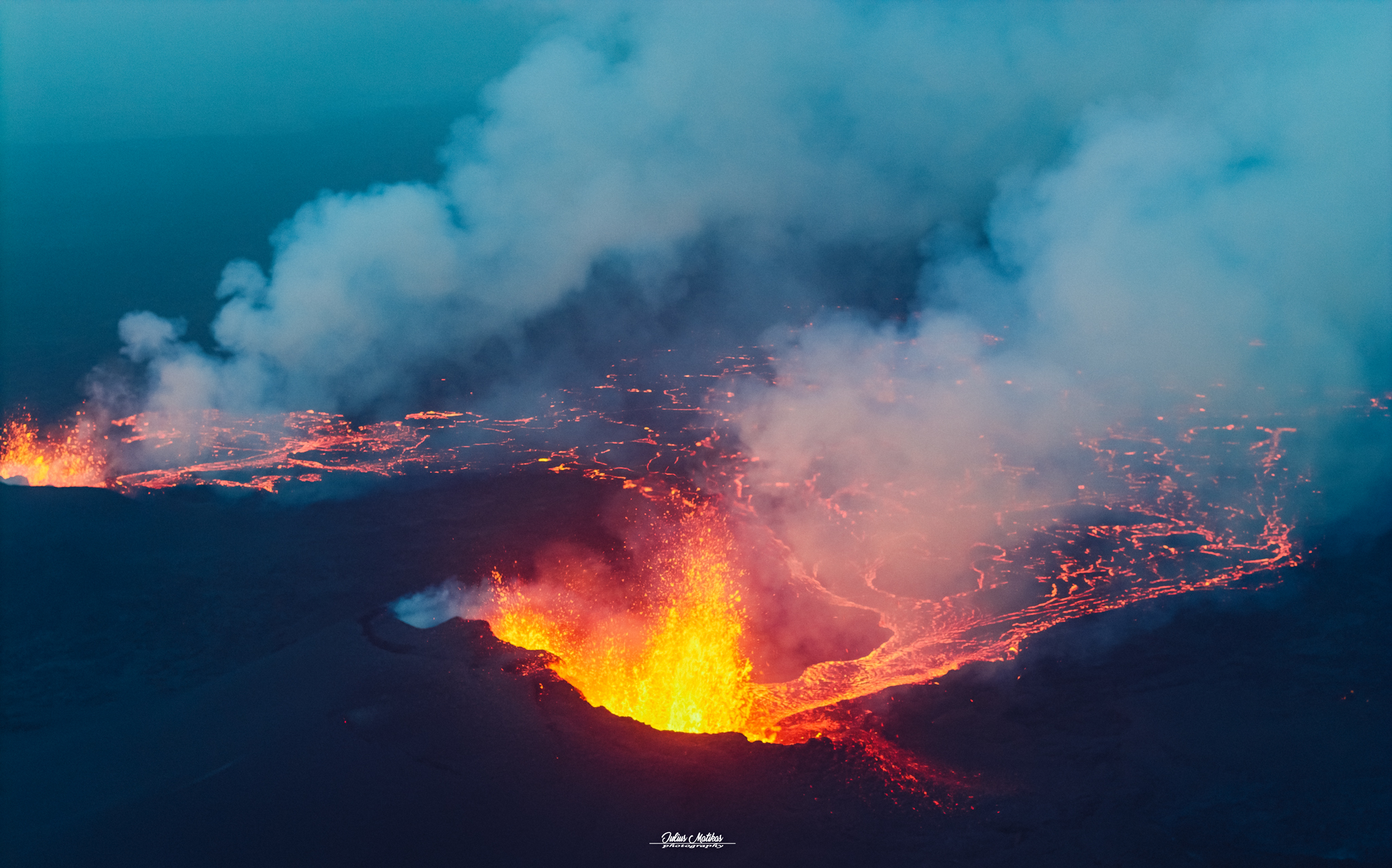
Iceland , Reykjanes Peninsula :
Eruption ongoing on the Sundhnúkur crater row ; Updated 11:30, 19 July
Ongoing volcanic haze across Iceland
The volcanic eruption on the Sundhnúkur crater row remains active, with gas and volcanic haze spreading widely across the country in recent days. The eruption has remained stable overnight and since yesterday morning. Volcanic activity is focused on 2–3 craters at the central part of the fissure that formed on 16 July, and volcanic tremor remains low and steady.
Air pollution is not confined to areas near the eruption as it can travel long distances and linger over inhabited areas for extended periods.
Volcanic haze has formed under calm wind, humidity, and sunshine, affecting regions such as West Iceland, North Iceland, and the capital region.
This pollution appears mainly in two ways:
Gas pollution from sulfur dioxide (SO₂) near the eruption site.
Volcanic haze, formed when SO₂ reacts with moisture and oxygen in the atmosphere, turning into fine sulfate particles (SO₄) that can spread far and persist.
The latest meteorological forecasts indicate light winds from the west or variable directions, allowing pollution and haze to drift widely over South and Southwest Iceland, and even into the highlands in the coming hours.
The public is advised to monitor air quality at air quality (measurements and guidance) and vedur . is (forecasts and maps). Those sensitive to air pollution – such as children, elderly people, and individuals with lung conditions – should take precautions when volcanic haze levels are high.
Source : IMO
Photo : Julius Matikas via FB.
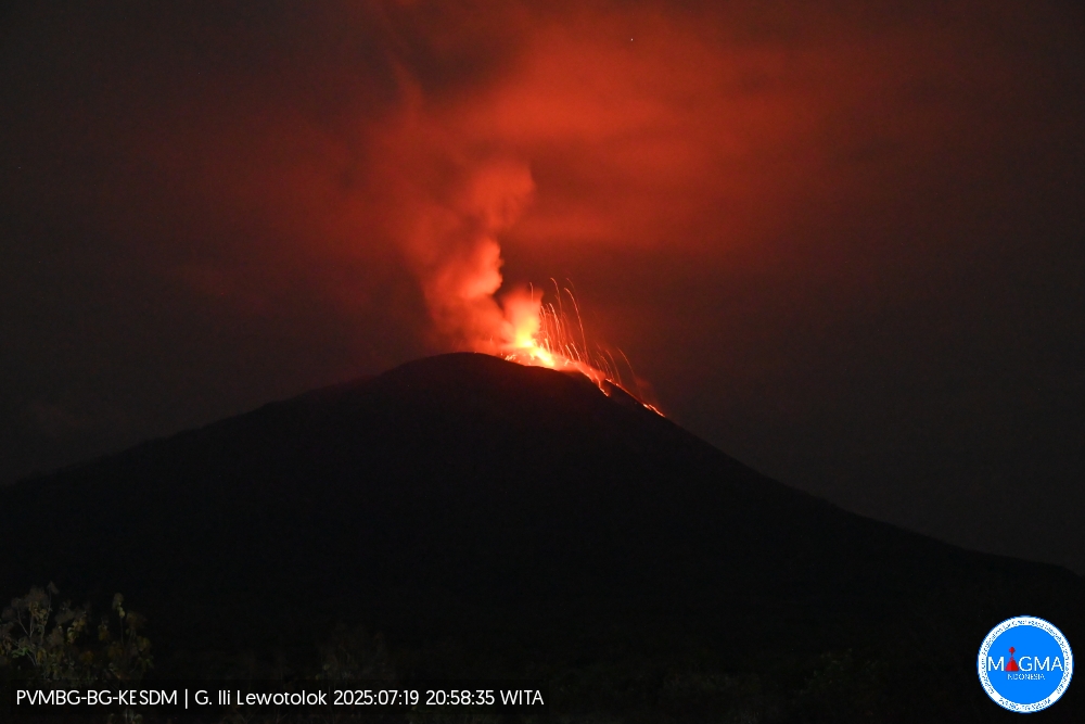
Indonesia , Ili Lewotolok :
An eruption of Mount Ili Lewotolok occurred on Saturday, July 19, 2025, at 8:58 PM WITA. An ash column was observed about 300 m above the summit (about 1,723 m above sea level). The ash column was white to gray in color, of moderate intensity, and directed westward. This eruption was recorded by seismograph with a maximum amplitude of 25.6 mm and a duration of 54 seconds.
Seismic Observations
35 eruption earthquakes with amplitudes ranging from 14.4 to 35 mm and durations ranging from 31 to 45 seconds.
47 emission earthquakes with amplitudes ranging from 1.6 to 9.7 mm and durations ranging from 28 to 39 seconds.
1 deep volcanic earthquake with amplitudes of 31.1 mm and durations of 19 seconds.
Recommendations
[1] Residents of the vicinity of Mount Ili Lewotolok, as well as visitors, mountaineers, and tourists, are advised to refrain from entering or participating in activities within a 3 km radius of the active area of Mount Ili Lewotolok. Be aware of the potential dangers of lava avalanches and pyroclastic flows originating from the southern, southeast, western, and northeast sectors of Mount Ili Lewotolok. (2) The public is advised not to panic if they hear a rumbling noise coming from the crater of Mount Ili Lewotolok, as this noise is characteristic of volcanic activity during an eruption. This powerful rumbling can cause severe vibrations in several parts of the building, particularly windows and glass doors.
Source et photo : Magma Indonésie .
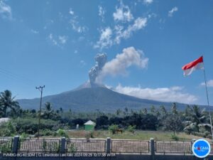
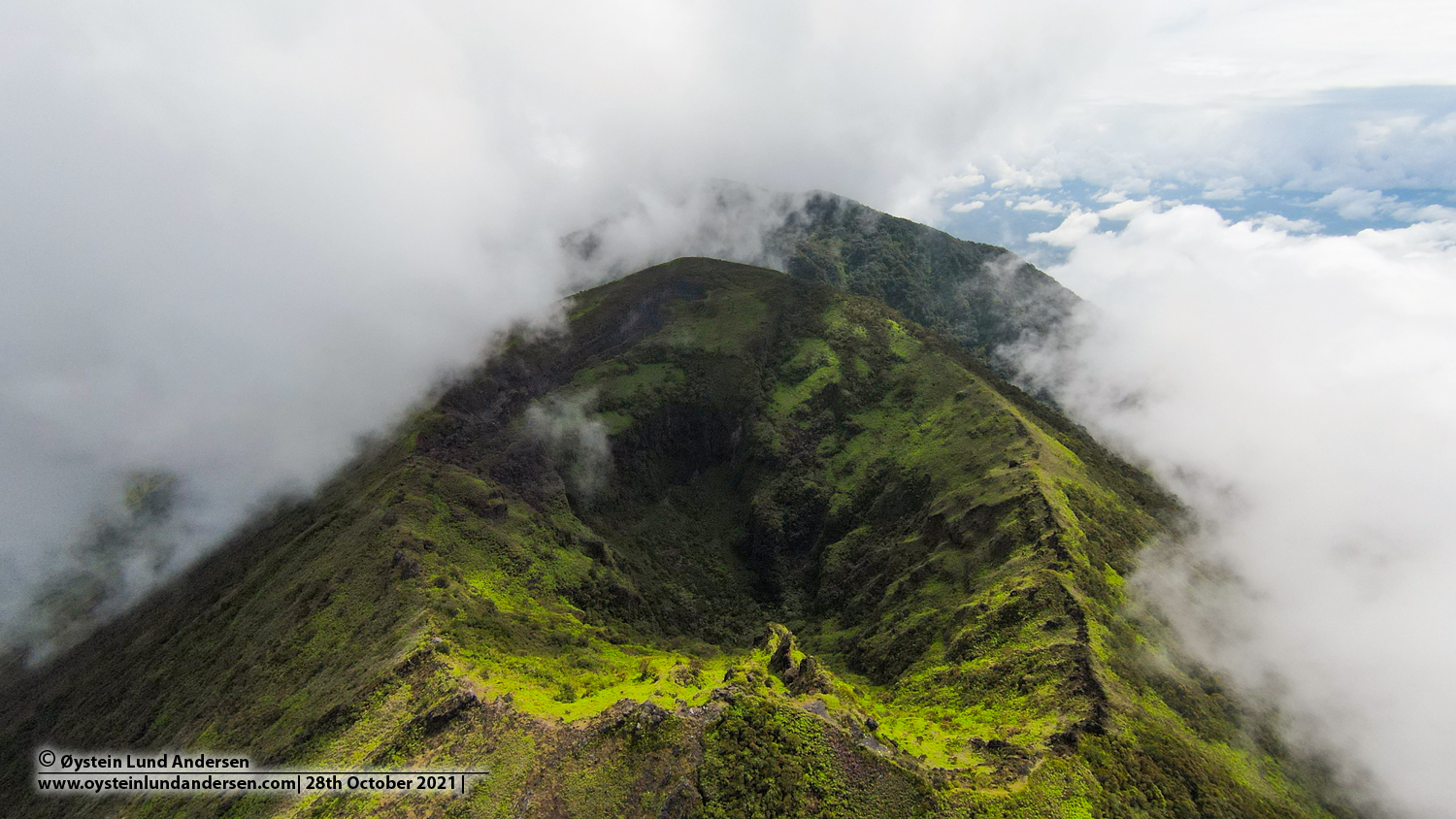
Indonesia , Lamongan :
SPECIAL REPORT ON THE INCREASE IN LOCAL TECTONIC EARTHQUAKES AT LAMONGAN VOLCANO.
Lamongan Volcano is an active volcano located in Lumajang Regency, East Java Province. Lamongan Volcano is a stratovolcano with a height of 1,651 meters above sea level. Lamongan Volcano has 64 satellite eruption centers consisting of 37 volcanic cones and 27 maars.
Lamongan Volcano exhibited an increase in local tectonic seismic activity during the period from July 1 to 18, 2025. Based on monitoring results conducted by the Geological Survey, 345 local tectonic earthquakes and 26 distant tectonic earthquakes were recorded at 7:00 PM WIB on July 18, 2025.
Visual monitoring showed that Lamongan Volcano was clearly visible until it was covered by fog. No crater smoke was observed during this period.
.
Over the past seven days in particular, an increase in local tectonic seismic activity has been observed, with a duration ranging from 0.9 to 3.5 km and a seismic depth of 1–13.5 km. The distribution of seismic activity has been identified on the east, southeast, and west sides of the mountain. Several earthquakes occurring on July 17 and 18 were also recorded by the seismic stations at Mount Semeru and Mount Bromo, indicating a fairly broad distribution of seismic waves.
Deformation data from the ANYR station’s inclinometer instrument indicate swelling within the body of Lamongan Volcano. This phenomenon indicates an increase in internal pressure associated with the active fault system within the volcanic complex.
This recorded slope trend is similar to a similar event that occurred on November 1, 2024, during a significant increase in local tectonic seismic activity in the same area. This reinforces the suspicion that active faults play a role in the subsurface pressure dynamics of Lamongan Volcano.
According to the results of the analysis of visual and instrumental data, the activity level of Lamongan Volcano remains at Level I (Normal).
Source: PVMBG.
Photo : Oystein Lung Andersen .
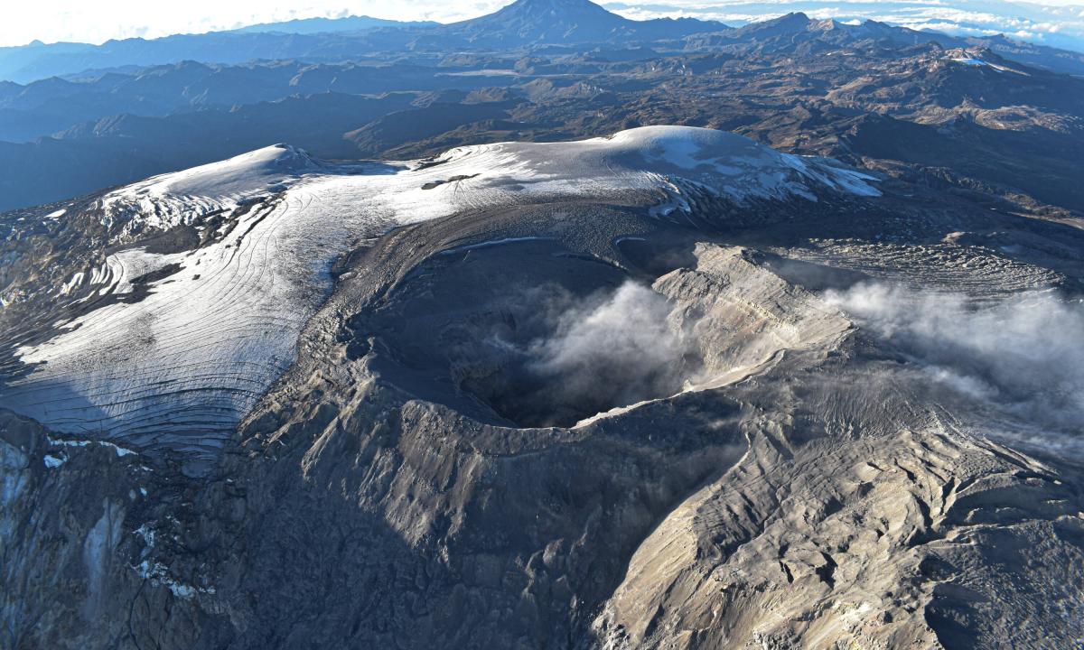
Colombia , Nevado del Ruiz :
Manizales, July 15, 2025, 5:45 a.m.
Regarding the monitoring of the activity of the Nevado del Ruiz volcano, the Colombian Geological Survey (SGC), an entity affiliated with the Ministry of Mines and Energy, reports that:
From July 8 to 14, 2025, the volcano continued to exhibit unstable behavior. Compared to the previous week, the main variations in the monitored parameters were:
– Seismic signals related to fluid dynamics in volcanic conduits increased, both in terms of the number of recorded events and the seismic energy released.
The energy levels of these signals ranged from low to moderate values, with a predominance of low values. Although atmospheric conditions of high cloud cover persisted in the region throughout the week, pulsed ash emissions associated with these signals were confirmed by cameras (conventional or thermographic) used to monitor the volcano. Variations in the apparent temperature of the emitted materials were also observed, linked to some of the recorded emissions. Of note is the apparent temperature estimate on July 9, linked to the ash emission recorded at 4:12 a.m. This change had not been observed for a month.
– Seismic activity associated with rock fracturing processes within the volcanic edifice led to an increase in the number of recorded earthquakes and a decrease in the released seismic energy. The seismic events were mainly located in the Arenas crater and scattered along the northeast, north, southeast, south, and northwest flanks of the volcano, at distances of up to 10 km from the crater. The depth of the earthquakes was less than 2 km for the earthquakes located in the crater, and between 2 km and 8 km for the earthquakes recorded in the other sectors mentioned above. The highest magnitude of the week was 1.2, corresponding to the earthquake recorded on July 12 at 11:11 p.m., located in the Arenas crater, at a depth of less than 2 km.
– Seismic activity related to the activity of the lava dome (protuberance or mound) located at the crater floor was recorded again, after an absence since last May. This activity was short-lived and showed low levels in terms of the number of events and the seismic energy released.
– The emission of water vapor and gases, mainly sulfur dioxide (SO2), into the atmosphere from the Arenas crater was variable. Estimated values of the flux associated with SO2 degassing were similar to those recorded the previous week. According to satellite monitoring currently underway to assess this parameter, SO2 emissions continue to be observed; however, a decrease in values is noticeable due to the heavy cloud cover prevailing in the volcanic area.
– The vertical height of the gas column remained below 700 m measured above the summit of the volcano, while its peak dispersion reached 1,700 m during the ash emission recorded on July 9 at 4:12 a.m. Regarding the column’s dispersion direction, it showed a predominant trend towards the Northwest and West-Northwest, and to a lesser extent towards the West-Southwest of the volcano. In accordance with these dispersion directions, on the morning of July 9, several reports of ash fall were received in the municipalities of Manizales (village of Alto del Naranjo), Palestina and Belalcázar, in the department of Caldas. According to petrographic analysis, the ash was fine to extremely fine in the aforementioned sectors. Ashfall was also reported in the Tumbas sector, in the Los Nevados National Natural Park area, in connection with the ash emission recorded on July 12 at 10:26 a.m.
Source et photo : SGC
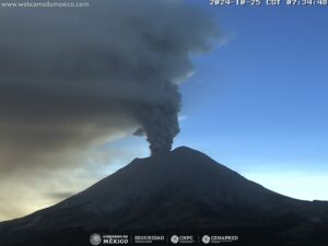
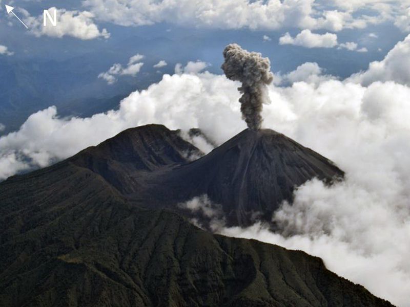
Ecuador , El Reventador :
DAILY STATUS REPORT OF REVENTADOR VOLCANO, Saturday, July 19, 2025.
Information Geophysical Institute – EPN.
Surface Activity Level: High, Surface Trend: No change
Internal Activity Level: Moderate, Internal Trend: No change
From July 18, 2025, 11:00 a.m. to July 19, 2025, 11:00 a.m.:
Seismicity:
Below is the count of seismic events recorded at the reference station.
Explosion (EXP) 83
Long Period (LP) 13
Emission Tremor (TREMI) 4
Harmonic Tremor (TRARM) 5
Precipitation/Lahars:
Precipitation was recorded in the volcanic area without generating mudflows or debris flows. **Heavy rainfall could remobilize accumulated material, generating mudflows and debris flows that would cascade down the volcano’s flanks and flow into adjacent rivers.**
Emissions/Ash Plume:
Due to adverse weather conditions, it was not possible to observe gas and/or ash emissions by surveillance cameras or satellite imagery. The Washington-based VAAC agency also did not publish an activity report for this volcano.
Observation:
From yesterday afternoon until the submission of this report, the volcano remained completely cloudy.
Alert Level – SGR: Orange
Source : IGEPN
Photo : F-Naranjo , GVP.