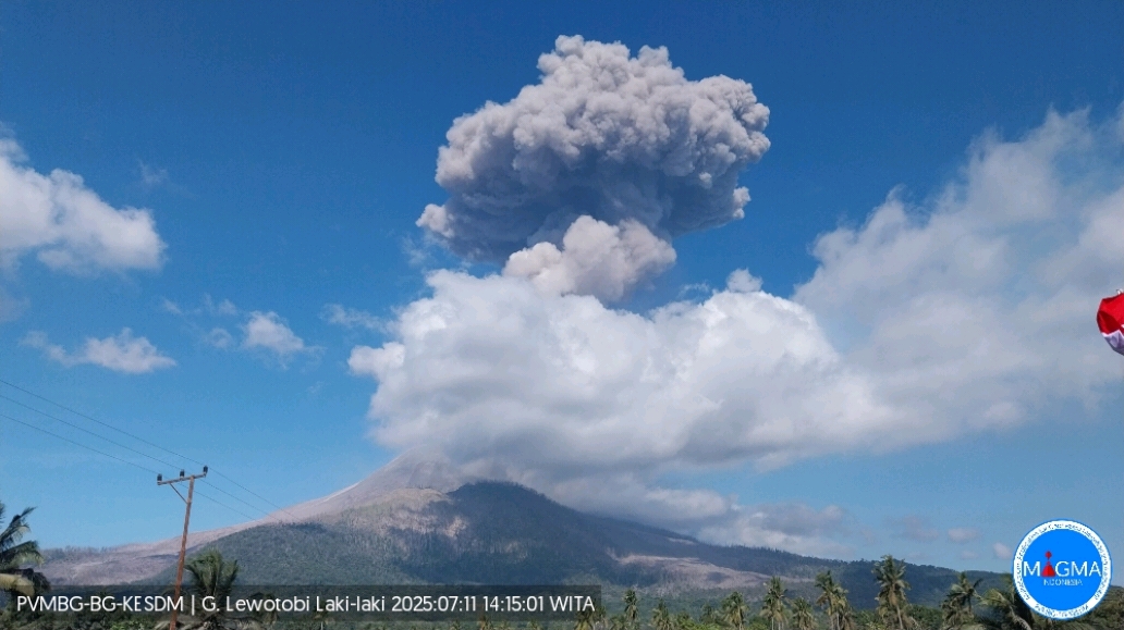
July 12 , 2025.
Indonesia , Lewotobi Laki-Laki :
An eruption of Mount Lewotobi Laki-laki occurred on Friday, July 11, 2025, at 2:10 PM (local time). An ash column was observed about 4,000 m above the summit (about 5,584 m above sea level). The ash column was gray and dense, oriented toward the west and northwest. This eruption was recorded by seismograph with a maximum amplitude of 47.3 mm and a duration of 111 seconds..
VOLCANO OBSERVATORY NOTICE FOR AVIATION – VONA
Issued : July 11 , 2025
Volcano : Lewotobi Laki-laki (264180)
Current Aviation Colour Code : ORANGE
Previous Aviation Colour Code : orange
Source : Lewotobi Laki-laki Volcano Observatory
Notice Number : 2025LWK357
Volcano Location : S 08 deg 32 min 20 sec E 122 deg 46 min 06 sec
Area : East Nusa Tenggara, Indonesia
Summit Elevation : 5069 FT (1584 M)
Volcanic Activity Summary :
Eruption with volcanic ash cloud at 06h10 UTC (14h10 local).
Volcanic Cloud Height :
Best estimate of ash-cloud top is around 17869 FT (5584 M) above sea level or 12800 FT (4000 M) above summit. May be higher than what can be observed clearly. Source of height data: ground observer.
Other Volcanic Cloud Information :
Ash cloud moving from west to northwest. Volcanic ash is observed to be gray. The intensity of volcanic ash is observed to be thick.
Remarks :
Eruption recorded on seismogram with maximum amplitude 47.3 mm and maximum duration 111 second.
Source : Magma Indonésie .
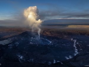
Alaska , Spurr :
Unrest continues at Mount Spurr. The level of activity remains slightly above background but continues to decline since the peak of unrest earlier this year. The decrease in activity suggests that the magma intrusion beneath Mount Spurr has stalled and that the likelihood of an eruption has declined.
Earthquake activity continues, with a small number of earthquakes located beneath both the summit of Mount Spurr and Crater Peak. The number of earthquakes and their magnitudes continue to show some variability from week to week but are following a decreasing trend. Ground deformation, as measured by GNSS (GPS) stations, remains paused as it has for the last two months. Volcanic gas emissions continue, as would be expected from a passively degassing body of stalled magma.
Fluctuations in unrest are common at volcanoes and eruptive activity remains possible, but unlikely. Should unrest escalate towards an eruption, we would expect to observe increases in seismic activity, gas emissions, surface deformation, and surface heating
AVO continues to closely monitor activity at Mount Spurr for signals indicating the volcano is moving closer to an eruption using local seismic, infrasound, and GNSS (GPS) stations, web cameras, airborne and satellite gas measurements, regional infrasound, lightning networks, and satellite images.
Source : AVO .
Photo : Loewen, Matt/ AVO/USGS.
United States , Mount Rainier :
CASCADES VOLCANO OBSERVATORY STATUS REPORT , U.S. Geological Survey
Friday, July 11, 2025, 9:12 AM PDT (Friday, July 11, 2025, 16:12 UTC)
46°51’11 » N 121°45’36 » W,
Summit Elevation 14409 ft (4392 m)
Current Volcano Alert Level: NORMAL
Current Aviation Color Code: GREEN
This is an update on the ongoing seismic swarm at Mount Rainier that began at 1:29 AM PDT (8:29 UTC) on July 8th.
Swarm event rates continue to decrease. As of 9 AM PDT (16:00 UTC) on July 11th, the Cascades Volcano Observatory (CVO) and the Pacific Northwest Seismic Network (PNSN) have located 391 events since the start of the swarm, although many more have occurred but cannot be located. The largest event of the swarm so far was a magnitude 2.3 on July 8th at 2:56 PM PDT (21:56 UTC).
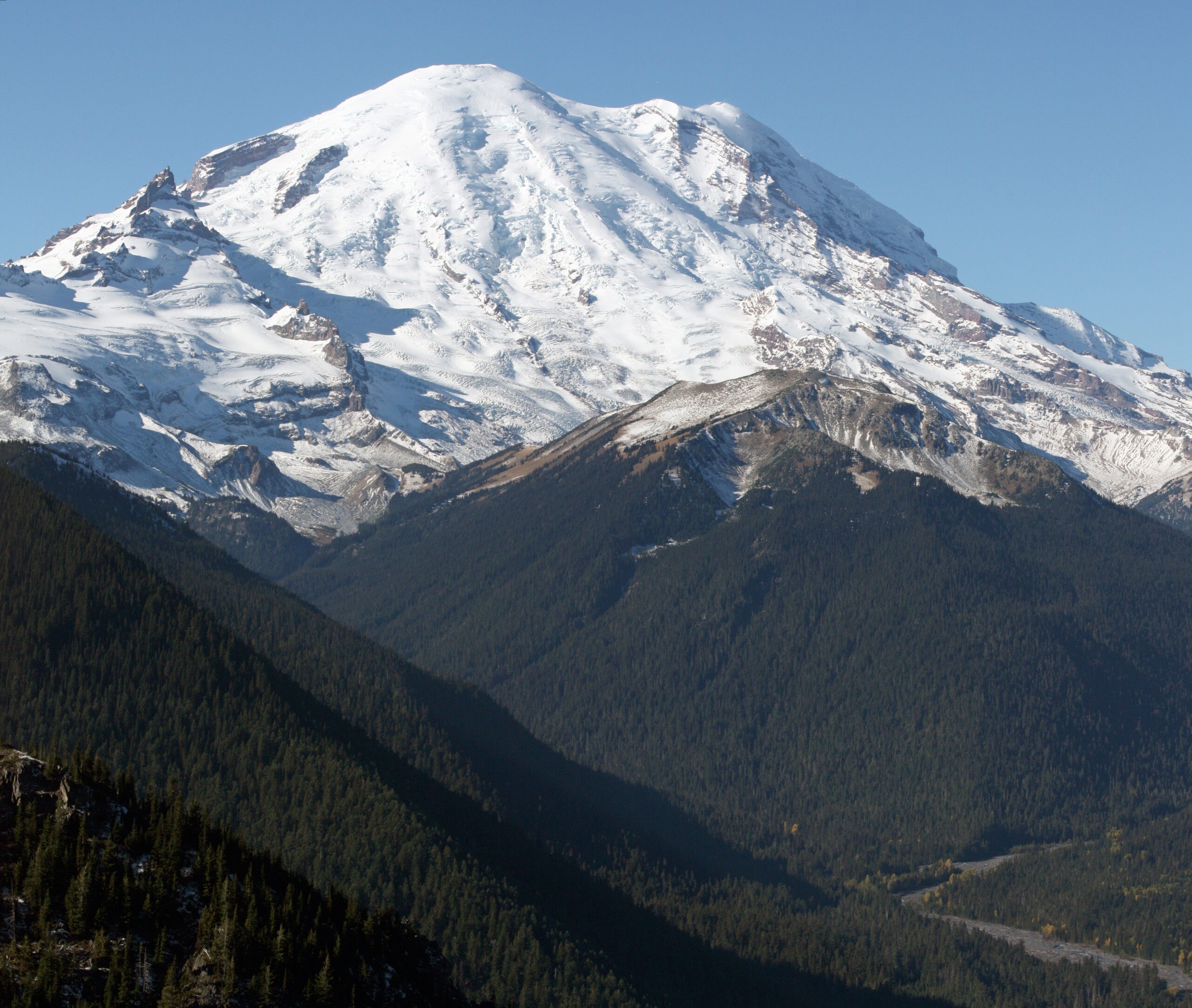
Seismicity has decreased from 30 located events per hour at the swarm’s peak on Tuesday morning to a few events per hour as of Friday morning. The earthquakes are mainly spread between 1.5-4 miles (2-6 km) beneath the summit. There have been no changes in ground deformation or other monitoring data.
This swarm surpassed the 2009 swarm in terms of total events, event rate, and energy release. The cause of the swarm remains consistent with the circulation of fluids along preexisting faults beneath the volcano, which is considered background activity at Mount Rainier. There is currently no indication that the swarm is associated with magmatic unrest.
The PNSN and the CVO will continue to monitor activity, locate earthquakes and provide additional information if necessary.
Source : CVO
Photo : Walter Siegmund / wikipedia.
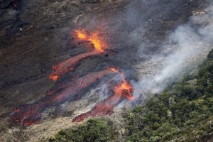
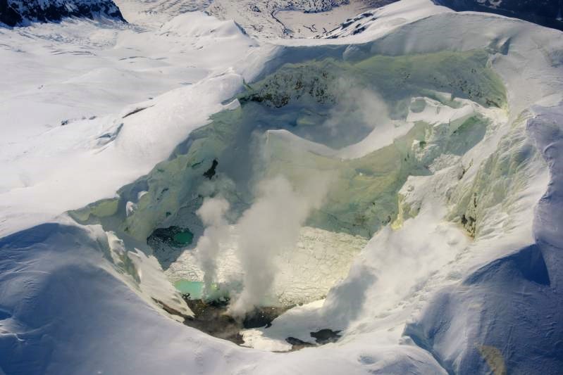
Costa Rica , Poas :
OVSICORI-UNA Weekly Volcano Monitoring Bulletin, July 11, 2025
Latitude: 10.20°N;
Longitude: 84.23°W;
Altitude: 2,687 m
Current Activity Level: Caution
Following the eruption on May 19, no explosive events were recorded.
This week, the amplitude of the continuous seismic tremor remains low and stable compared to recent months. The acoustic tremor, originating from Vent A, remains generally stable, but its intensity is decreasing compared to last week. The number of long-period events has decreased compared to last week.
This week, two volcano-tectonic events were recorded on the southern flank, at depths close to sea level.
In recent weeks, subsidence of the volcano has been observed, accompanied by a slight contraction of the crater.
MultiGAS stations measured an average SO2/CO2 ratio of 1.7 ± 0.7 this week, similar to last week’s. The H2S/SO2 ratio has remained very low (< 0.1) in recent weeks. The gases are interpreted to be originating from a surface magmatic source.
The average SO2 flux this week was 526 ± 401 t/d, similar to last week’s (441 ± 74 t/d). The mass of SO2 measured in the Costa Rican atmosphere by the TROPOMI sensor on the Sentinel-5P satellite indicates values between approximately 300 and 500 tons.
The level of the new Boca C lake remained stable this week. The temperature of Boca A remains very high (> 530°C, measured from the observation platform).
Source : Ovsicori .
Photo : Archive Ovsicori
Colombia , Galeras :
San Juan de Pasto, July 8, 2025, 4:20 p.m.
Regarding the monitoring of the activity of the Galeras Volcano, the Colombian Geological Survey (SGC), an entity attached to the Ministry of Mines and Energy, reports that:
During the week of July 1-7, 2025, the main variations in the monitored parameters compared to the previous week were:
● A decrease in seismic occurrence and energy was observed. The predominance of seismic activity associated with rock fracture processes within the volcanic edifice continued.
● A few low-energy earthquakes were located near the main crater, at depths less than 4 km from the Galeras summit (4,200 m above sea level). Other events were located about 18 km southwest of the volcanic summit, at depths between 15 and 19 km (reference level around 4,200 m altitude), and with a maximum magnitude of 1.8.
● Low-altitude white gas columns were observed, with variable dispersion depending on the wind, emanating from the fumarole fields of El Paisita, to the north, and Las Chavas, to the west of the active cone.
● Other volcanic monitoring parameters showed stability.
Based on the above, the SGC recommends closely monitoring developments through weekly bulletins and other information published through our official channels, as well as instructions from local and departmental authorities and the National Disaster Risk Management Unit (UNGRD).
Volcanic activity remains on alert. Yellow: Active volcano with changes in the baseline behavior of monitored parameters and other manifestations.
Source et photo : SGC .