Japan , Shinmoedake :
The Japan Meteorological Agency (JMA) reported that an eruption occurred at Shinmoedake (Shinmoe peak, a stratovolcano of the Kirishimayama volcano group) on 22 June, the first eruption since 27 June 2018. The number of volcanic earthquakes with epicenters directly beneath Shinmoedake had been fluctuating since late October 2024 but began to increase starting around 13 June. Another increase occurred at around 21h00 on 21 June, and volcanic tremor increased on 22 June. An eruption detected during 16h37-17h55 on 22 June produced an ash plume that rose 500 m above the crater rim and drifted E. Ashfall was confirmed in a wide area to the NE that included Takaharu Town, Kobayashi City, Miyazaki City, Kunitomi Town, Saito City, and Shintomi Town in Miyazaki Prefecture. A large amount of ashfall in Hirohara, Takaharu-cho, Miyazaki Prefecture obscured the white lines on the roadway. Sulfur dioxide emissions averaged 4,000 tons per day on 23 June; no emissions were detected on 15 May during the last measurement. On 23 June the Alert Level was raised to 3 (on a 5-level scale) and the public was warned to exercise caution within 3 km from Shinmoedake Crater.
Kirishimayama is a large group of more than 20 Quaternary volcanoes located north of Kagoshima Bay. The late-Pleistocene to Holocene dominantly andesitic group consists of stratovolcanoes, pyroclastic cones, maars, and underlying shield volcanoes located over an area of 20 x 30 km. The larger stratovolcanoes are scattered throughout the field, with the centrally located Karakunidake being the highest. Onamiike and Miike, the two largest maars, are located SW of Karakunidake and at its far eastern end, respectively. Holocene eruptions have been concentrated along an E-W line of vents from Miike to Ohachi, and at Shinmoedake to the NE. Frequent small-to-moderate explosive eruptions have been recorded since the 8th century.
Sources: Japan Meteorological Agency (JMA) , GVP .
Photo : Via Alex Terry / FB.
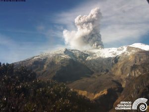
The Volcanological and Seismological Monitoring Center (CMVS) is currently responsible for analyzing these phenomena and issuing preventive alerts if signs of imminent risk are detected. Authorities emphasize the importance of understanding the dynamics of active volcanoes in regions such as Chiapas, characterized by high geological activity.
Although no signs of an imminent eruption have been observed, monitoring remains active. Authorities emphasize that the eruption of the Chichonal volcano in 1982 had devastating consequences in the region; therefore, it is essential not to underestimate signs of a possible reactivation.
The public is advised to stay informed through official sources and follow the instructions of the Civil Protection Department. Continuous monitoring will be essential to anticipate any risk scenarios and protect surrounding communities.
El Chichón ( or Chichonal) is a small trachyandesitic tuff cone and lava dome complex in an isolated part of the Chiapas region in SE México. Prior to 1982, this relatively unknown volcano was heavily forested and of no greater height than adjacent non-volcanic peaks. The largest dome, the former summit of the volcano, was constructed within a 1.6 x 2 km summit crater created about 220,000 years ago. Two other large craters are located on the SW and SE flanks; a lava dome fills the SW crater, and an older dome is located on the NW flank. More than ten large explosive eruptions have occurred since the mid-Holocene. The powerful 1982 explosive eruptions of high-sulfur, anhydrite-bearing magma destroyed the summit lava dome and were accompanied by pyroclastic flows and surges that devastated an area extending about 8 km around the volcano. The eruptions created a new 1-km-wide, 300-m-deep crater that now contains an acidic crater lake.
Source : elsoldechiapas , GVP.
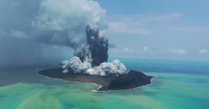
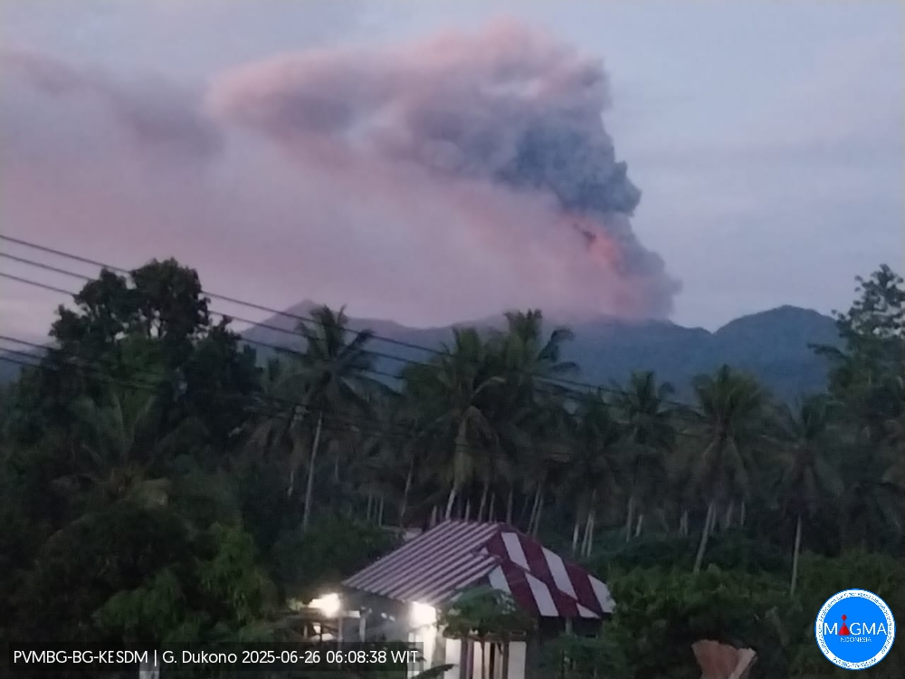
Indonesia , Dukono :
G. Dukono erupted on Thursday, June 26, 2025, at 5:59 a.m. (local time). The observed ash column was ± 1,200 m above the summit (± 2,287 m above sea level). The ash column was white to gray, with significant intensity, oriented toward the east. At the time of this report, the eruption was still ongoing.
Seismicity Observation:
291 eruption earthquakes with an amplitude of 6 to 34 mm and a duration of 32.8 to 73.8 seconds.
2 distant tectonic earthquakes with an amplitude of 8 to 28 mm and a duration of 73.8 to 78.85 seconds.
1 continuous tremor with an amplitude of 2 to 5 mm, with a dominant value of 3 mm.
Recommendations
(1) Residents of the vicinity of Mount Dukono and visitors/tourists should not engage in any activities, climb, or approach the Malupang Warirang crater within a 4 km radius. (2) Since volcanic ash eruptions occur periodically and the distribution of ash follows the direction and speed of the wind, so the ash area is not fixed, people around Mount Dukono are recommended to always carry masks/nose and mouth covers to use when needed to avoid the threat of volcanic ash to the respiratory system.
Source et photo : Magma Indonésie .
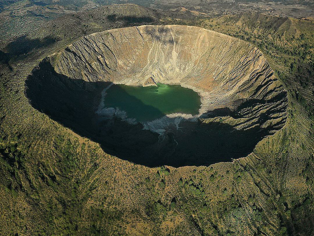
Costa Rica , Poas :
The Observatorio Vulcanológico y Sismológico de Costa Rica-Universidad Nacional (OVSICORI-UNA) reported continuing gas-and-steam emissions with occasional minor amounts of ash at Poás during 18-24 June. Significant amounts of gas-and-steam emissions continued to be emitted, particularly from Boca A. On 18 June sulfur dioxide emissions averaged 273 tons per day (t/d), though they were as high as 1,500 t/d towards the second half of the week; overall, though levels remained high, there has beenwas a decreasing trend in sulfur dioxide emissions during over the previous few weeks, though levels remained high. Gas component ratios indicated less of a magmatic input. Incandescence continued to be visible and detected in infrared webcam views at Boca A vent. The hyperacid lake over Boca C continued to rise, notably on 15 June during a period of heavy rain.
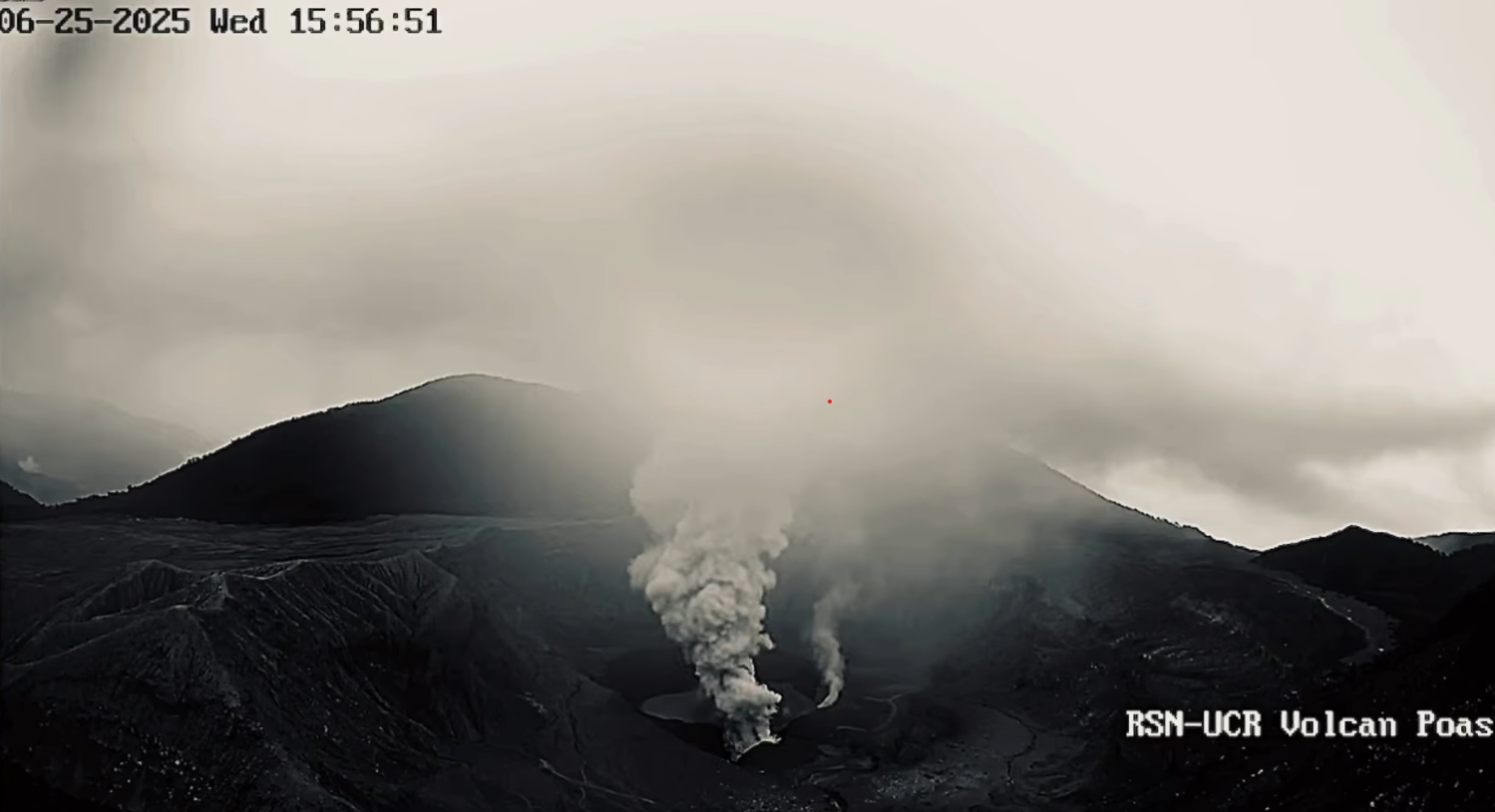
Minor amounts of ash in the gas-and-steam plume were visible in webcam images during 17h25-19h00 on 22 June. The plumes rose 500 m above the crater rim and drifted W. The Comisión Nacional de Emergencias (CNE) lowered the Alert Level to Yellow for Parque Nacional Volcán Poás and district of Toro Amarillo in the Canton of Sarchí (including the Desagüe, Agrio, Anonos, and Gorrión river basins) on 18 June due to decreasing activity. Additionally, the districts of Grecia, Zarcero, Naranjo, Poás, Sabanilla, Sarapiquí, and Rio Cuarto were no longer under “alert.” The Parque Nacional Volcán Poás remained closed. The Alert Level remained at 2 (the second lowest level on a four-level scale) and the Aviation Color Code remained at Yellow (the second lowest color on a four-color scale).
Sources: Observatorio Vulcanologico y Sismologico de Costa Rica-Universidad Nacional (OVSICORI-UNA), Comisión Nacional de Prevención de Riesgos y Atención de Emergencias (CNE), GVP.
Photo : RSN-UCR.
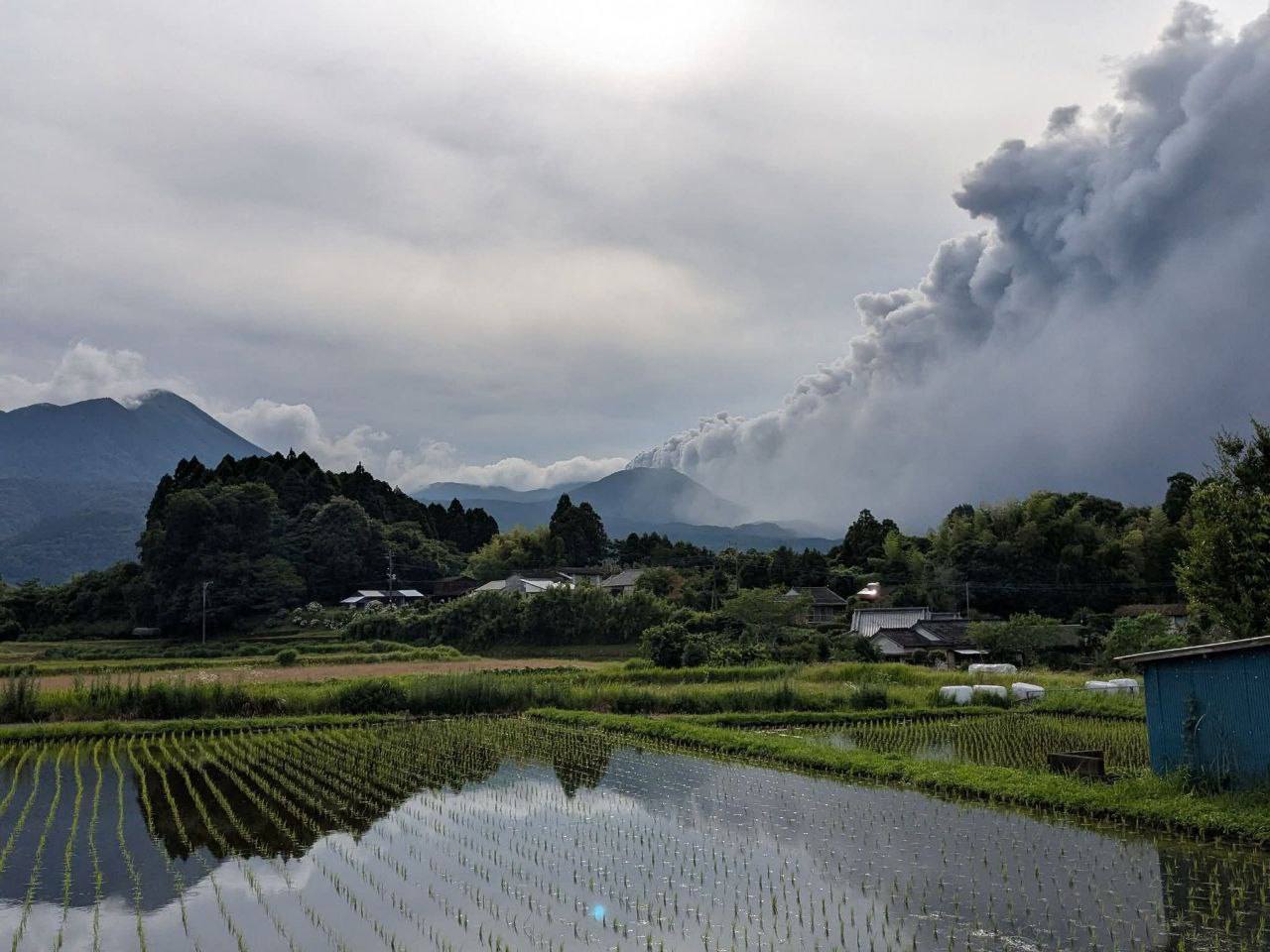
Japan , Miyakejima :
The Japan Meteorological Agency (JMA) reported that the number of small volcanic earthquakes at Miyakejima decreased after a peak on 17 June that led to an Alert Level change. On 17 June the number of small volcanic earthquakes with epicenters directly below the summit crater totaled 59, and uplift near the summit was detected in tiltmeter data. During 18-23 June the number of daily earthquakes decreased to 0-4 earthquakes per day and no changes in tilt were detected after 18 June. The Alert Level remained at 2 (on a 5-level scale) and the public was warned to be cautious in areas inside the Oyama Ring Road.
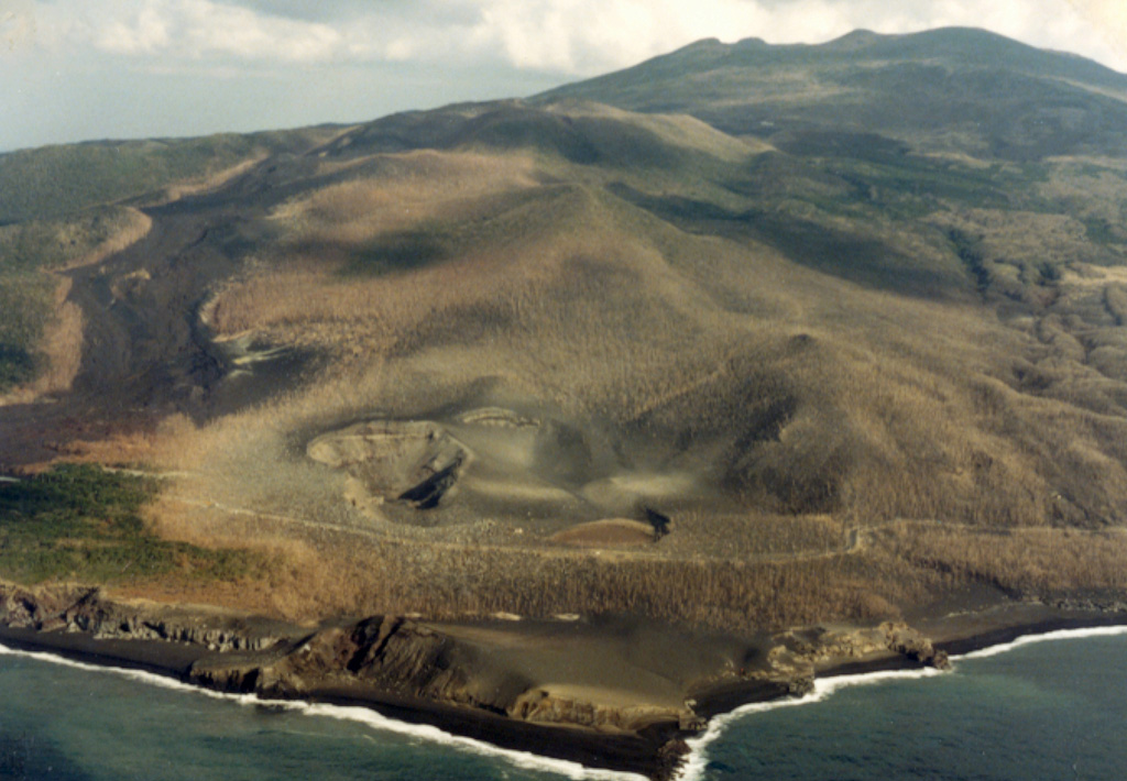
The craters in the foreground and the lava flow to the right erupted in 1983 from vents on the SW flank of Miyakejima. The 8-km-wide island rises about 1.1 km from the sea floor in the northern Izu Islands, about 200 km SSW of Tokyo. The summit cone of Oyama (upper right) lies within a caldera that formed about 3,000 years ago. Frequent eruptions have occurred since 1085 CE at vents ranging from the summit to below sea level.
The circular, 8-km-wide island of Miyakejima forms a low-angle stratovolcano that rises about 1,100 m from the sea floor in the northern Izu Islands about 200 km SSW of Tokyo. The basaltic volcano is truncated by small summit calderas, one of which, 3.5 km wide, was formed during a major eruption about 2,500 years ago. Numerous craters and vents, including maars near the coast and radially oriented fissure vents, are present on the flanks. Frequent eruptions have been recorded since 1085 CE at vents ranging from the summit to below sea level, causing much damage on this small populated island. After a three-century-long hiatus ending in 1469 CE, activity has been dominated by flank fissure eruptions sometimes accompanied by minor summit eruptions. A 1.6-km-wide summit crater was slowly formed by subsidence during an eruption in 2000.
Sources: Japan Meteorological Agency (JMA), GVP.
Photo : Ichio Moriya (Université de Kanazawa) / GVP .