June 12 , 2025.
Hawaii , Kilauea :
HVO/USGS Volcanic Activity Notice
Current Volcano Alert Level: WATCH
Current Aviation Color Code: ORANGE
Issued: Wednesday, June 11, 2025, 12:39 PM HST
Source: Hawaiian Volcano Observatory
Notice Number: 2025/H276
Location: N 19 deg 25 min W 155 deg 17 min
Elevation: 4091 ft (1247 m)
Area: Hawaii
Volcanic Activity Summary:
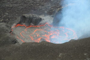
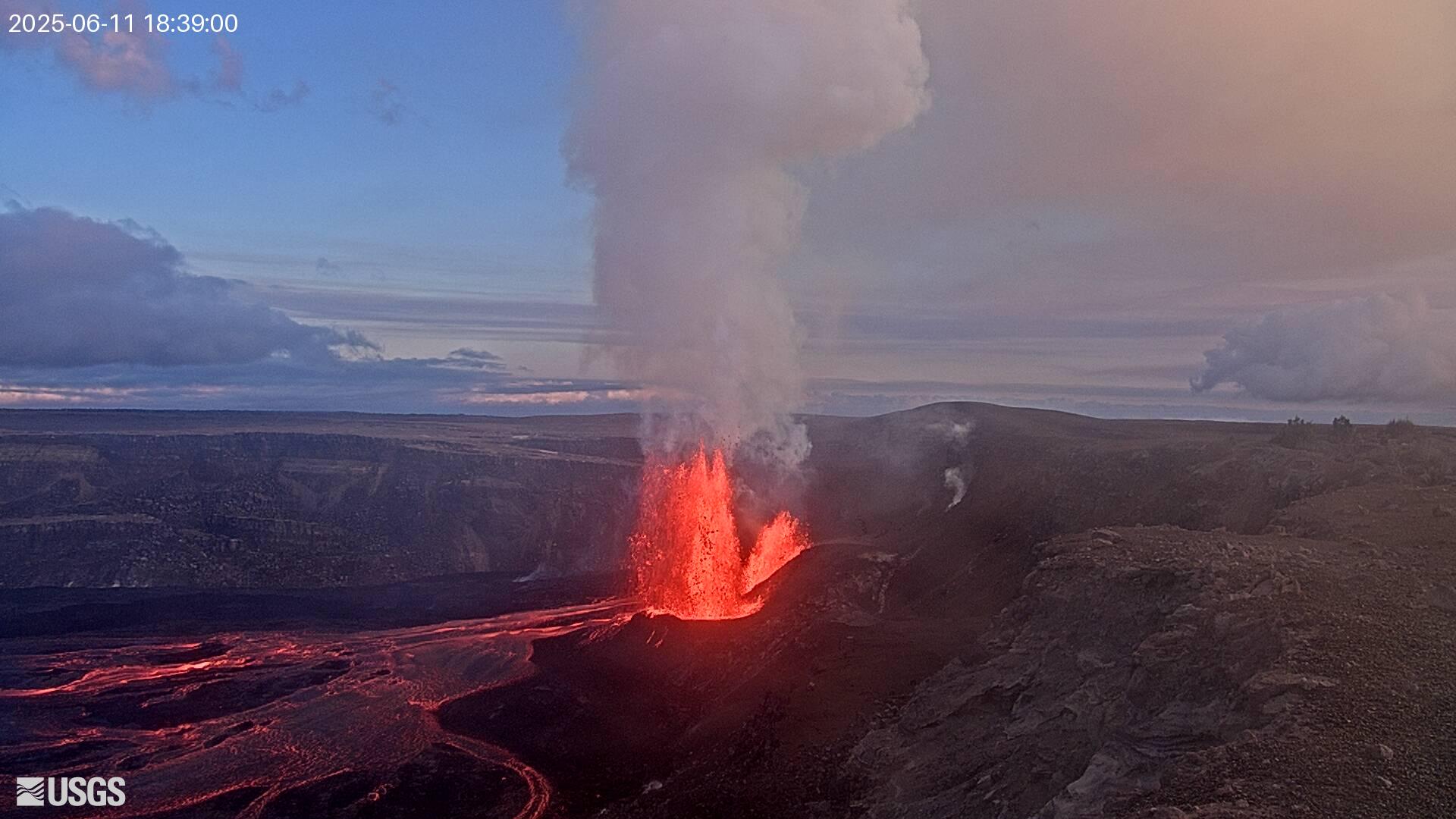
Episode 25 of the ongoing Halemaʻumaʻu eruption began at 11:57 a.m. HST on June 11, 2025, and the volume and vigor of lava fountains and flows has increased markedly as of 12:30 p.m. Lava is currently fountaining from the north vent, reaching heights of approximately 330 feet (100 meters).
Episode 25 was preceded by intermittent gas-pistoning in the north vent, with associated small spatter fountains and lava flows which began before dawn on June 10. This activity, which occurred at a rate of about 5-10 gas piston events per hour, continued to increase in intensity until 11:57 a.m. on June 11, when a small sustained dome fountain began to feed lava flows onto the crater floor. As of 12:30 p.m. HST, fountains from the north vent are reaching about 165 feet (50 meters) high and feeding multiple lava streams. Fountains heights are likely to increase in the coming hours.
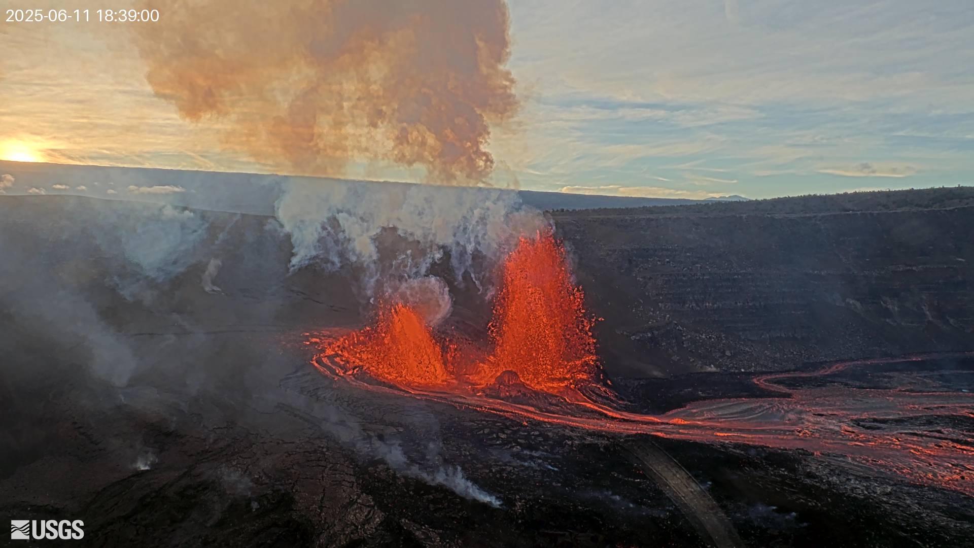
Inflationary tilt reached just over 15 microradians since the end of the last episode. Seismic tremor began increasing and tilt at UWD switched from inflation to deflation at about 12 p.m. HST, about the same time lava flows began erupting onto the crater floor.
Most episodes of Halemaʻumaʻu lava fountaining since December 23, 2024, have continued for around a day or less and have been separated by pauses in eruptive activity lasting generally at least several days.
No changes have been detected in the East Rift Zone or Southwest Rift Zone. A VAN/VONA will be issued when sustained lava fountaining ceases and the eruption is paused, or earlier if the situation warrants a further update.
Source et photos : HVO
Guatemala , Fuego :
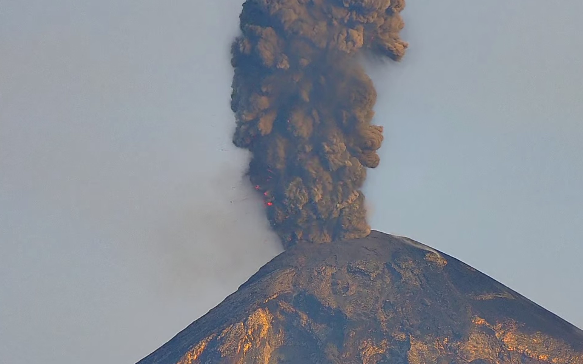
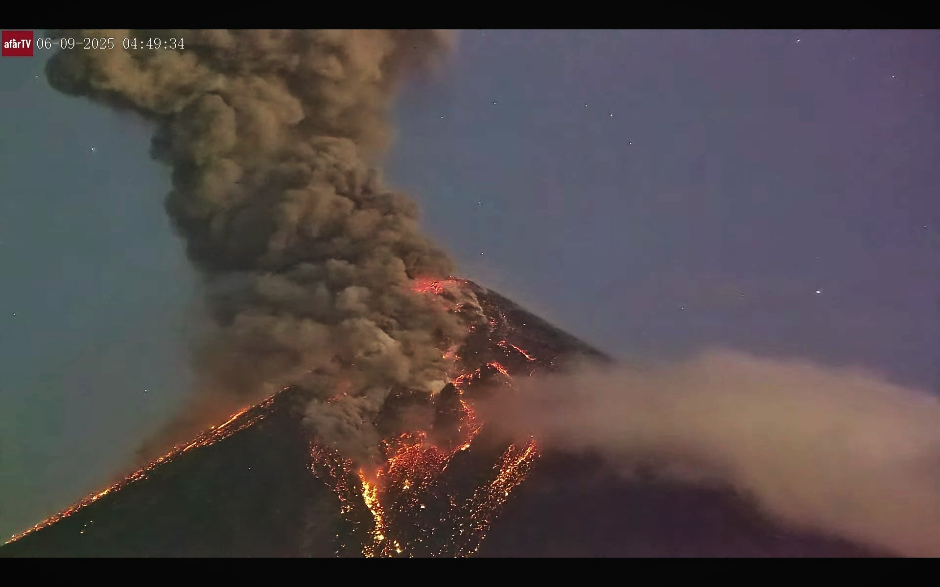
The Instituto Nacional de Sismología, Vulcanologia, Meteorologia e Hidrología (INSIVUMEH) reported that elevated activity at Fuego on 4 June was characterized by lava fountaining, dense ash plumes, and pyroclastic density currents (PDCs). In a statement issued at 20h30 on 4 June INSIVUMEH noted that there was a shift in eruption style to more effusive activity with abundant gas emissions and the ejection of incandescent material that covered the entire crater area and upper W flank. Lava fountaining became continuous, constant avalanches of material descended the flanks, and lava descended the Seca-Santa Teresa drainage (W) as far as 600 m. The activity continued through the night.
Just before 05h00 on 5 June weak-to-moderate PDCs descended the Seca, Ceniza (SSW), and Las Lajas (SE) drainages. During 05h00-11h05 several more moderate-to-strong PDCs mainly descended the Las Lajas drainage, but also the Seca and Ceniza drainages, to as far as 7 km. Ash plumes rose from the summit and rose several hundred meters along the PDC tracks and drifted SW, W, and NW. Ashfall was reported in the municipalities of Acatenango (8 km E) and San Pedro Yepocapa (8 km NW) according to the Coordinadora Nacional para la Reducción de Desastres (CONRED). The Ministry of Environment and Natural Resources (SE-CONRED) issued an Orange Alert for the municipality of San Juan Alotenango and the municipality of Gimnasio. Ash plumes drifted as far as 60 km W and SW. By 12h30 PDCs were also descending the La Trinidad (SSW) drainage.
. SE-CONRED announced that an Orange Alert was extended to the departments of Sacatepéquez, Chimaltenango, and Escuintla and classes were suspended at 43 schools in those departments. At around 15h25 lahars that were possibly hot descended the El Jute (ESE) and Las Lajas drainages carrying tree branches, trunks, and blocks possibly as large as 3 m in diameter. By 16h00 lahars were traveling down the Ceniza, Zarco, and Mazate rivers and again carried tree branches, trunks, volcanic material, and blocks possibly as large as 3 m in diameter. During the next hour additional lahars descended the Seca and Mineral (W) drainages, tributaries of the Pantaleón River. CONRED coordinated with Instituto Privado de Investigacio´n sobre Cambio Clima´tico (ICC) to evacuate about 600 residents in Panimaché I and II (8 km SW), El Rodeo (10 km SSE), Trinidad (21 km SE), and Morelia (9 km SW), though a news article noted that 700 had evacuated. A section of the National Route 14 (RN-14) was closed.
In a special report issued at 19h25 On 5 June INSIVUMEH reported that PDCs continued to travel up to 7 km down multiple drainages. Ash-and-gas plumes from the PDCs rose several hundred meters high and drifted NW, W, and SW. By 00h15 on 6 June a lava flow in the Ceniza drainage was 1.2 km long. Incandescent material on the SW flank was visible in webcam images. Ash from the descent of PDCs was not visible due to weather clouds around the volcano. Incandescent material was periodically ejected above the summit and landed on the flanks about 30 m from the crater rim. CONRED reported that activity significantly decreased during the early morning, after about 30 hours of the generation of lava flows, PDCs, and ash plumes. Incandescent material was no longer being ejected above the summit and ash was no longer suspended in the atmosphere based on webcam images.
During 6-7 June the seismic network recorded 4-6 explosions per hour. Ash-and-gas plumes rose as high as 1.1 km above the summit and drifted 10-30 km SW. Some explosions generated rumbling and shock waves. Incandescent material was ejected 200 m above the summit. Explosions during 8-9 June generated ash plumes that rose around 700 m above the summit and drifted 25 km W and SE. The explosions produced rumbling and shock waves, and generated block avalanches around the summit area and down various drainages. Weather clouds obscured views during 9-10 June, though infrasound instruments detected 2-8 explosions per hour. Faint sounds of blocks descending the flanks were reported and webcams captured incandescent blocks descending the Seca, Ceniza, and Las Lajas drainages. Ashfall was reported in several communities to the SW, including San Pedro Yepocapa, Panimaché I and II, Morelia, Santa Sofía (12 km SW), Los Yucales (12 km SW), and El Porvenir (8 km ENE).
Sources : Instituto Nacional de Sismologia, Vulcanologia, Meteorologia, e Hidrologia (INSIVUMEH), Coordinadora Nacional para la Reducción de Desastres (CONRED), TV Azteca Guate , GVP.
Photos : afar tv , 06/06/2025
Japan , Suwanosejima :
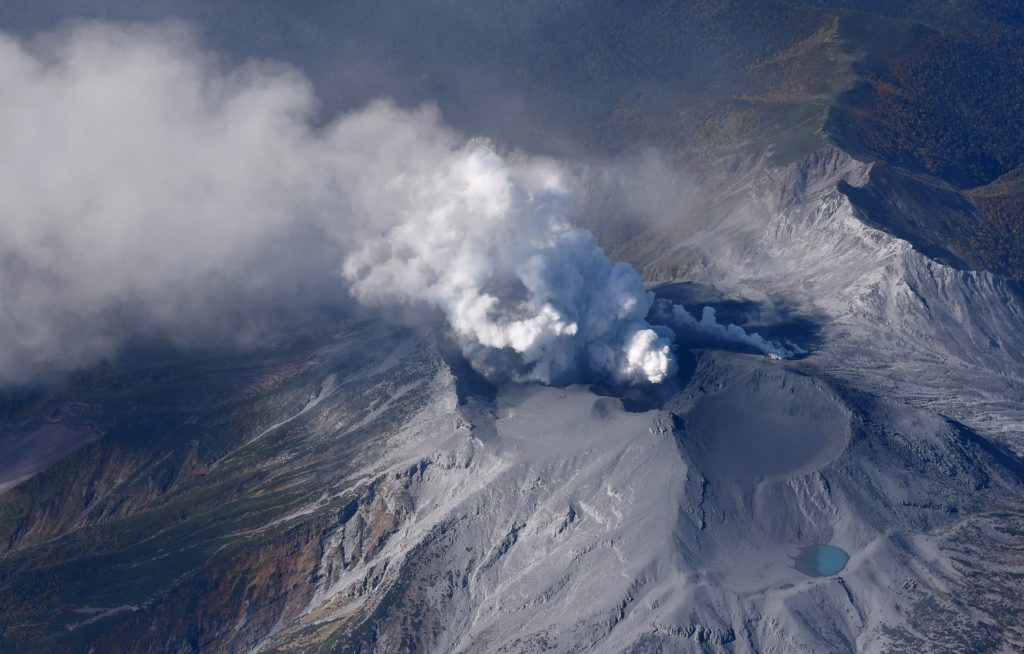
The Japan Meteorological Agency (JMA) reported that eruptive activity at Suwanosejima’s Ontake Crater continued during 2-9 June. Incandescence was observed nightly in webcam images. No explosions were detected, though ash-and-gas emissions were continuous during 4-7 June. The plumes rose as high as 1.3 km above the crater rim and blocks were ejected 300 m from the vent. Ashfall was reported by the Suwanosejima Branch of the Toshima Village Office (3.5 km SSW) on 5 June. The Alert Level remained at 2 (the second level on a five-level scale) and the public was warned to be cautious within 1.5 km of the crater.
The 8-km-long island of Suwanosejima in the northern Ryukyu Islands consists of an andesitic stratovolcano with two active summit craters. The summit is truncated by a large breached crater extending to the sea on the E flank that was formed by edifice collapse. One of Japan’s most frequently active volcanoes, it was in a state of intermittent Strombolian activity from Otake, the NE summit crater, between 1949 and 1996, after which periods of inactivity lengthened. The largest recorded eruption took place in 1813-14, when thick scoria deposits covered residential areas, and the SW crater produced two lava flows that reached the western coast. At the end of the eruption the summit of Otake collapsed, forming a large debris avalanche and creating an open collapse scarp extending to the eastern coast. The island remained uninhabited for about 70 years after the 1813-1814 eruption. Lava flows reached the eastern coast of the island in 1884. Only about 50 people live on the island.
Sources : Agence météorologique japonaise (JMA) , GVP .
Photo : Masanori Genko
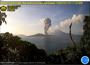
Indonesia , Raung :
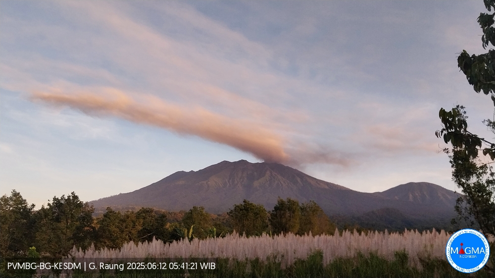
Mount Raung erupted on Thursday, June 12, 2025, at 5:41 a.m. Eastern Time. The observed ash column was ± 1,000 m above the summit (± 4,332 m above sea level). The ash column was white to gray, with moderate intensity, oriented toward the south. At the time of this report, the eruption was still ongoing.
The Pusat Vulkanologi dan Mitigasi Bencana Geologi (PVMBG) reported that ash was present in emissions at Raung during 5-7 June. Emissions became continuous around 06h00 on 5 June. The ash-bearing white to medium-gray plumes rose 600 m above the summit and drifted NE. Seismic energy did not increase and deformation data showed subsidence, suggesting that the source of the emissions was relatively shallow. Gray gas-and-ash plumes were continuous on 7 June, and possibly continuous at least through 23h29 on 8 June, rising to 400 m above the crater rim. Ashfall was reported in the Linggusar and Sumberwringin area, Bondowoso Regency, about 17 km NNW. The Alert Level remained at 2 (on a scale of 1-4) and the public was warned to stay 3 km away from the summit crater.
VOLCANO OBSERVATORY NOTICE FOR AVIATION – VONA
Issued : June 12 , 2025
Volcano : Raung (263340)
Current Aviation Colour Code : ORANGE
Previous Aviation Colour Code : orange
Source : Raung Volcano Observatory
Notice Number : 2025RAU014
Volcano Location : S 08 deg 07 min 30 sec E 114 deg 02 min 31 sec
Area : East java, Indonesia
Summit Elevation : 10662 FT (3332 M)
Volcanic Activity Summary :
Eruption with volcanic ash cloud at 22h41 UTC (05h41 local).
Volcanic Cloud Height :
Best estimate of ash-cloud top is around 13862 FT (4332 M) above sea level or 3200 FT (1000 M) above summit. May be higher than what can be observed clearly. Source of height data: ground observer.
Other Volcanic Cloud Information :
Ash cloud moving to south. Volcanic ash is observed to be white to gray. The intensity of volcanic ash is observed to be medium.
Remarks :
Tremor recorded on seismogram with maximum amplitude 4 mm. Seismic activity is characterized by continuous tremor.
Source et photo : PVMBG.
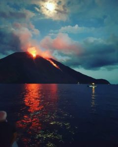
Tonga Islands , Home Reef :
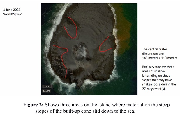
The Tonga Geological Services reported that the eruption at Home Reef continued during 24 May-7 June. Satellite images from 27 May showed explosive activity with an ash-and-gas plume rising from an enlarged crater and drifting around 20 km SE. Thermal data after that event showed a drop in heat output, and effusion and explosive activity stopped. Shadows created by the plume made crater size estimates difficult, but a clear satellite view on 1 June showed that it was about 110 x 245 m. There were also three landslide areas, on the E, NW, and SW coasts, originating from the flanks of the cone that may have occurred during the 27 May activity. The Aviation Color Code remained at Yellow (the second lowest level on a four-level scale, the Maritime Alert Level remained at Orange (the third level on a four-level scale) with advice to stay at least 2 nautical miles (3.7 km) from the island, and the Alert Level for residents of Vava’u and Ha’apai remained at Green (the first level on a four-level scale).
Home Reef, a submarine volcano midway between Metis Shoal and Late Island in the central Tonga islands, was first reported active in the mid-19th century, when an ephemeral island formed. An eruption in 1984 produced a 12-km-high eruption plume, large amounts of floating pumice, and an ephemeral 500 x 1,500 m island, with cliffs 30-50 m high that enclosed a water-filled crater. In 2006 an island-forming eruption produced widespread dacitic pumice rafts that drifted as far as Australia. Another island was built during a September-October 2022 eruption.
Source: Tonga Geological Services, Government of Tonga, GVP.