June 09 , 2025.
Hawaii , Kilauea :
Sunday, June 8, 2025, 9:06 AM HST (Sunday, June 8, 2025, 19:06 UTC)
19°25’16 » N 155°17’13 » W,
Summit Elevation 4091 ft (1247 m)
Current Volcano Alert Level: WATCH
Current Aviation Color Code: ORANGE
Activity Summary:
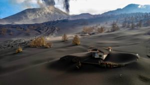
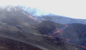
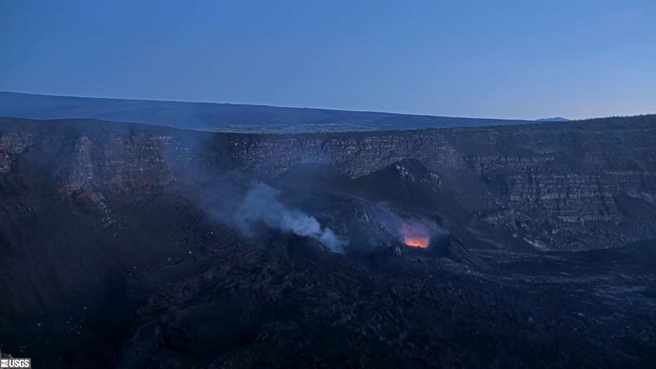
The ongoing Halema‘uma‘u eruption is currently paused. Episode 24 ended on June 5. Summit inflation has resumed, along with persistent, low level seismic tremor. Glow was visible from the south vent overnight.
Fountaining episodes have occurred approximately once per week since the start of the eruption on December 23, 2024. All eruptive activity remains within Hawaiʻi Volcanoes National Park. No significant activity has been noted along Kīlauea’s East Rift Zone or Southwest Rift Zone. Current hazards include volcanic gas emissions and windblown volcanic glass (Pele’s hair) and tephra that have impacted Hawaiʻi Volcanoes National Park and nearby communities.
Summit Observations:
Episode 24 ended at approximately 4:28 a.m. on June 4. Lava flows from this episode on the floor of Halemaʻumaʻu within the southern part of Kaluapele (Kīlauea caldera) may continue to exhibit slow movement or incandescence as the cool and solidify over the coming days.
Data analysis has confirmed that lava fountains from episode 24 reached heights of approximately 1,200 feet (365 meters), which were slightly higher than episode 23, and a new record for the current eruption. Several yards (meters) of tephra were deposited on the southwestern rim of Kaluapele, in a closed area of Hawaiʻi Volcanoes National Park, during the high fountaining of episode 24. As much as 2 feet (60 centimeters) of tephra were deposited at a location 1.5 miles (2.4 km) southwest of the eruptive vents.
A tiltmeter near Uēkahuna (UWD) has recovered about 9 microradians of inflationary tilt since the end of episode 24. As a result, the forecast window for episode 25 has shifted slightly since yesterday and is currently between Wednesday, June 11 and Saturday, June 14. This window is subject to change depending on changes in the rate of inflationary tilt.
The average sulfur dioxide (SO2) emission rate during inter-episode pauses is typically around 1,200 tonnes per day (t/d).
Source et photo : HVO
New Zealand , White Island :
No further detections of ash emissions at Whakaari/White Island.
Published: Mon Jun 9 2025 4:00 PM
Based on observations in recent weeks, including webcam and satellite imagery, no further ash emissions have been detected at Whakaari/White Island. The Volcanic Alert Level is lowered to 2 and the Aviation Colour Code to Yellow.
Since 17 April, Whakaari/White Island was undergoing a minor volcanic eruption. This was primarily based on satellite detections of volcanic ash from the island. Observations from GeoNet cameras in the Bay of Plenty and satellite imagery over the past four weeks and a monitoring flight today has confirmed the eruption has stopped, with no detectable ash emissions from the volcano.
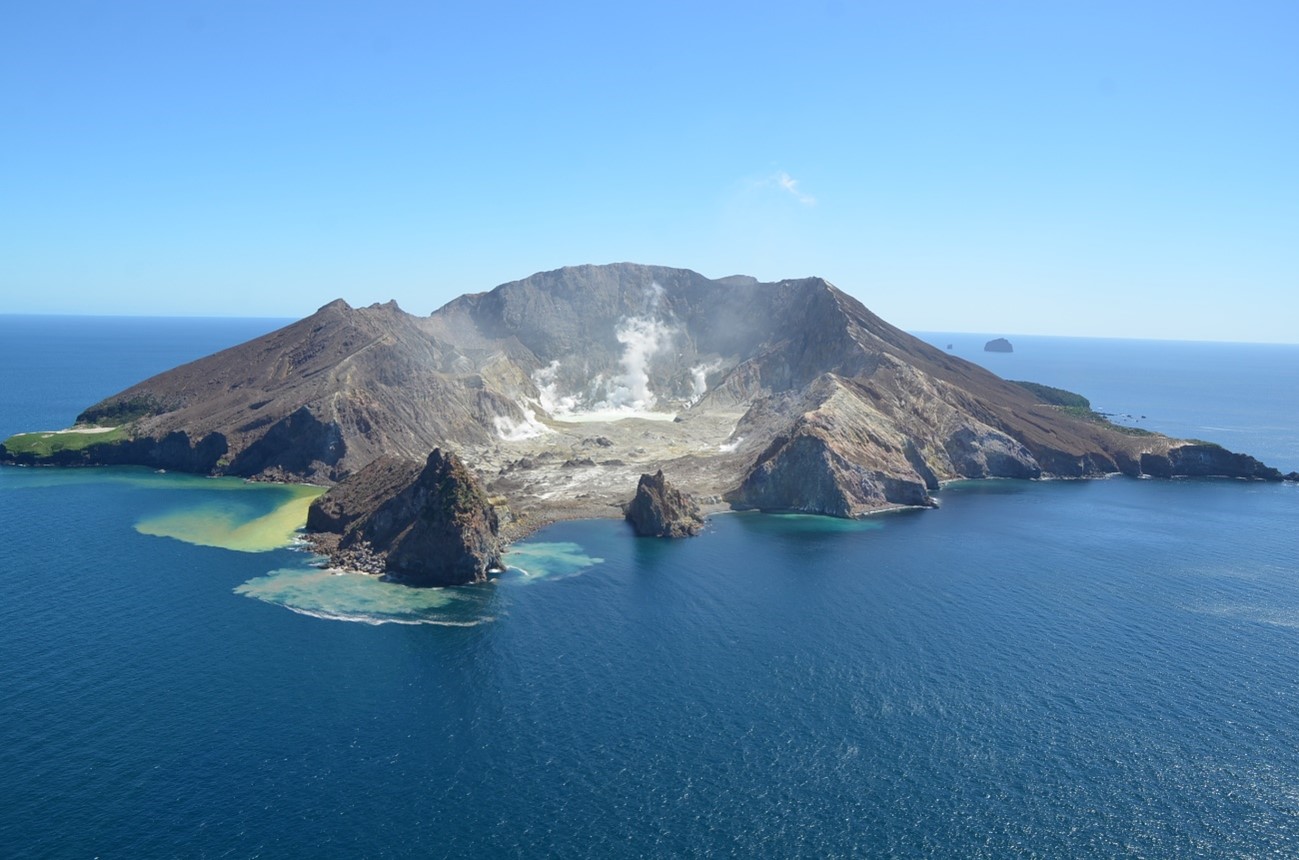
Observations from our cameras at Whakatāne and Te Kaha and a monitoring flight today have shown that the level of activity from the active vent area has decreased, with no indications of eruptive activity or ash emissions in the last four weeks. Over the same period, our colleagues at MetService have not detected any volcanic ash in the plume using satellite imagery.
We have carefully evaluated the level of volcanic activity and have lowered the Volcanic Alert Level to 2 (moderate-heightened unrest) and the Aviation Colour Code to Yellow. These levels acknowledge the current level of activity but also reflect the degree of uncertainty about the unrest level due to the current lack of real-time monitoring data from the island – volcanic activity could escalate with little or no warning. Further sudden, more explosive events could therefore affect the crater floor area and immediate vicinity of the island.
Source : Geonet / Oliver Lamb / Duty Volcanologist
Photo : Brad Scott, GNS Science.
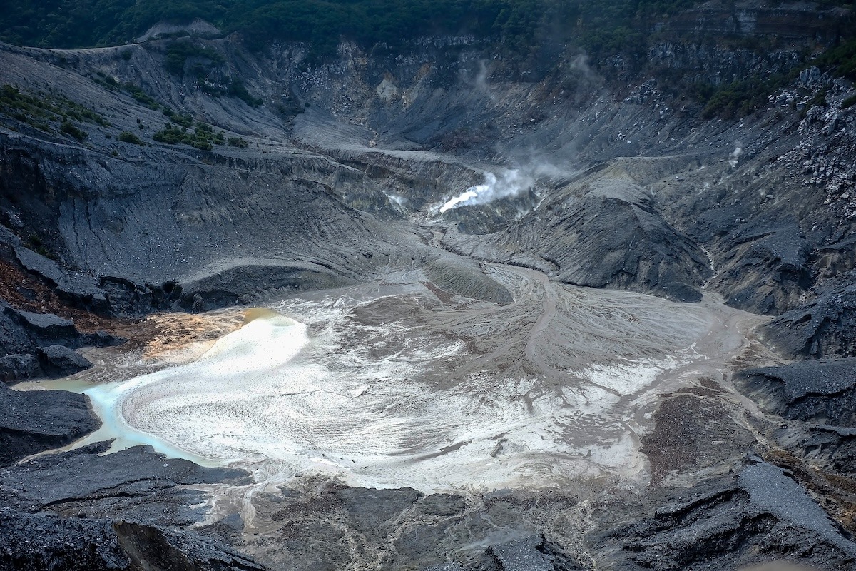
Indonesia , Tangkuban Parahu :
TANGKUBAN PARAHU VOLCANO ACTIVITY, WEST JAVA, JUNE 8, 2025.
Tangkuban Parahu is an active volcano located in the West Bandung and Subang districts of West Java province. It has nine craters, including two main summit craters: Ratu Crater and Upas Crater.
Visual observations have detected thin to moderate white smoke, ranging in height from 5 to 150 meters at the floor of Ratu Crater and from 5 to 10 meters at the floor of Ecoma Crater, with low to moderate pressure. Currently, mudflow activity is limited to Ratu Crater. Black mud deposits have been observed in the area surrounding this mud pool..
Thermal monitoring conducted by the Mavic Pro 3T drone at Ratu and Ecoma craters revealed no expansion of hotspots in these two craters, compared to thermal photos taken between June 5 and 7, 2025.
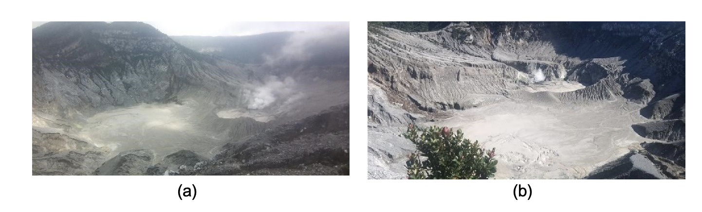
Visual conditions of the Ratu Crater of Mount Tangkuban Parahu on June 7, 2025 (a) and June 8, 2025 (b), with thin to moderate white smoke observed from Ratu Crater.
The formation of mud bubbles in Ratu Crater, according to seismic records, began on June 5, 2025, around 22:00 WIB, when continuous tremor vibrations began to be recorded. To date, the seismic activity of Mount Tangkuban Parahu remains dominated by continuous tremor vibrations. The recording from June 8, 2025, until 12:00 WIB, included three low-frequency (LF) earthquakes and continuous tremor with a maximum amplitude between 0.5 and 1.5 mm (dominant value at 1 mm). According to monitoring data from June 7, 2024, 16 low-frequency (LF) earthquakes were recorded, as well as continuous tremor vibrations with an amplitude of 0.5 to 2 mm.
EDM and GNSS observations of surface deformation continue to show an inflationary trend, indicating a buildup of pressure at shallow depths beneath the volcano. This phenomenon remains a concern, as phreatic eruptions can occur suddenly, without being preceded by obvious volcanic symptoms.
Until June 8, 2025, gas measurements taken by the permanent Multi-GAS station revealed no significant changes in the composition of volcanic gases, including the CO₂/SO₂, CO₂/H₂S, or SO₂/H₂S ratios. The gas concentration measured on June 8, 2025, at the western end of Ratu Crater using the portable Multi-GAS station also remained within normal limits.
Considering all of the above data, the activity level of Mount Tangkuban Parahu remains at Level I (normal). Communities around Mount Tangkuban Parahu and visitors are still advised to avoid the crater base, not to linger in the active area, and to move away immediately if the intensity of gusts increases or a strong smell of gas is detected. Although activity has decreased, vigilance remains essential. The regional government and the BPBD are requested to continue their coordination with the Tangkuban Parahu Volcano Observation Post, located in the village of Cikole, and the Bandung Volcanology and Geological Disaster Mitigation Center.
The activity level of Mount Tangkuban Parahu will be assessed periodically or at any time in the event of a significant change. The public is urged to remain calm, vigilant, and follow the authorities’ instructions for everyone’s safety.
Source : PVMBG
Photos : PVMBG , Agoda . Com .
Chile , Laguna del Maule :
Special Report on Volcanic Activity (REAV), Maule Regions, Laguna del Maule Volcanic Complex, June 8, 2025, 3:10 a.m. local time (Continental Chile)
The National Geology and Mining Service of Chile (SERNAGEOMIN) announces the following preliminary information, obtained using the monitoring equipment of the National Volcanic Monitoring Network (RNVV), processed and analyzed at the Southern Andean Volcano Observatory (OVDAS):
On Sunday, June 8, 2025, at 1:00 a.m. (05:00 UTC), monitoring stations installed near the Laguna del Maule volcanic complex recorded an increase in the occurrence of volcano-tectonic earthquakes (associated with rock fracturing within the volcanic system), reaching a total of 112 earthquakes in the last few hours, characterizing this episode. seismic as a swarm of volcano-tectonic type earthquakes.
The earthquake characteristics after analysis are as follows:
TIME OF ORIGIN: 02:23 local time (06:23 UTC)
LATITUDE: 36.109° S
LONGITUDE: 70.579° W
DEPTH: 6.0 km
LOCAL MAGNITUDE: 1.6 (ML)
Observation:
At the time of this report, volcano-tectonic seismicity continues with lower-energy and recurring events.
The Volcanic Technical Alert remains at GREEN.
Source : Sernageomin
Photo : Álvaro Vivanco – Volcán Domos del Maule.
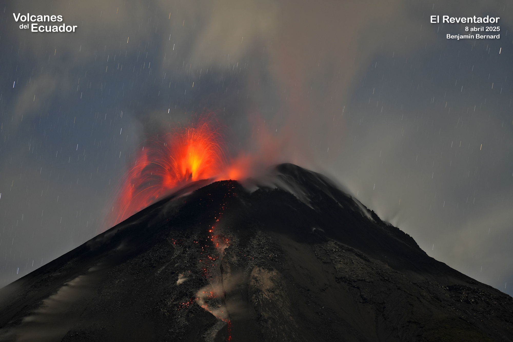
Ecuador , El Reventador :
DAILY STATUS REPORT OF REVENTADOR VOLCANO, Sunday, June 8, 2025.
Information Geophysical Institute – EPN.
Surface Activity Level: High, Surface Trend: No change
Internal Activity Level: Moderate, Internal Trend: No change
From June 7, 2025, 11:00 a.m. to June 8, 2025, 11:00 a.m.:
Seismicity:
Below is the count of seismic events recorded at the reference station.
Explosion (EXP) 66
Long Period (LP) 14
Emission Tremor (TREMI) 9
Harmonic Tremor (TRARM) 1
Rainfall/Lahars:
No rainfall was recorded in the region. **Heavy rainfall can remobilize accumulated material and generate debris-containing mudflows (lahars), which could cascade down the volcano’s flanks and flow into adjacent rivers.**
Emissions/Ash Plume:
Yesterday afternoon and early this morning, several gas and ash emissions were observed by the surveillance camera network at heights between 400 and 700 meters above the crater level, moving toward the west and northwest. Regarding this activity, the Washington-based VAAC agency published two reports of ash emissions reaching 800 meters above the crater level, oriented toward the west.
Other monitoring parameters:
The FIRMS satellite system detected two thermal anomalies, while the MIROVA-MODIS satellite system detected one.
Observation:
During the night and early morning, several episodes of incandescent material falling were observed on the flanks of the volcano, reaching 1,100 meters below the crater level. At the time of writing, the volcano remains entirely cloudy.
Alert Level – SGR: Orange
Source : IGEPN
Photo : Benjamin Bernard , Volcanes del Ecuador , 2/11/2024