June 08 , 2025.
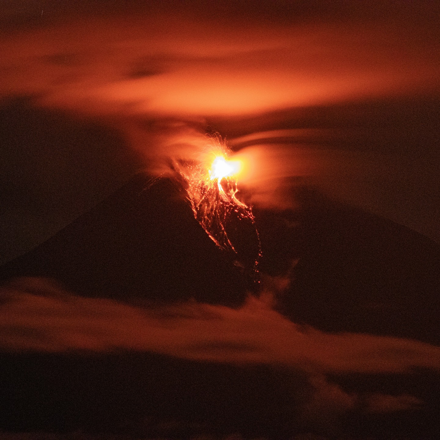
Guatemala , Fuego :
Atmospheric Conditions: Partly cloudy.
Wind: Northeast.
Precipitation: 26.2 mm.
Activity:
The Fuego Volcano Observatory reports rather favorable conditions for observing the crater due to cloud cover. Between four and six weak and moderate explosions are recorded per hour, projecting columns of grayish gas up to 4,400 to 4,800 meters above sea level. These columns move southwestward, driven by the wind, at distances of 10 to 30 km. Some of these explosions have generated weak to moderate rumbles and shock waves. Sounds similar to those of a locomotive have been heard due to the degassing. Incandescent material has been ejected 200 meters above the crater. Light ashfall is expected on Panimache I and II, Morelia, and the surrounding area. In the event of rain during the day, material deposited by the June 5 eruption could be carried away in the form of lahars, which may even be hot. It is recommended not to remain in or near these ravines in the event of rain on the volcanic edifice. Follow the recommendations in special bulletin BEFGO-013-2025.
The Directorate General of Civil Aeronautics informs: Due to recent rains, the main runway at La Aurora International Airport has been damaged, necessitating its temporary total closure, effective from 6:05 p.m. today, Saturday, until 3:00 a.m. Sunday, June 8.
During this period, several flights originally scheduled may be canceled or diverted to airports such as Mundo Maya and San Salvador International Airport, to avoid air traffic congestion when the airport reopens.
Sources : Insivumeh , DGAC .
Photo : Afar tv / FB , 07/06/2025
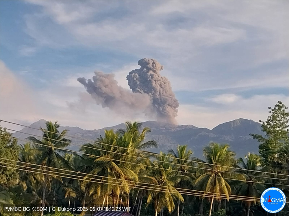
Indonesia , Dukono :
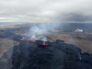
Mount Dukono erupted on Saturday, June 7, 2025, at 6:04 PM (local time). The observed ash column was ± 1,100 m above the summit (± 2,187 m above sea level). The ash column was white to gray, with a greater intensity, oriented toward the east. At the time of this report, the eruption was still ongoing.
Seismicity Observation:
292 eruption earthquakes with an amplitude of 6 to 34 mm and a duration of 31.45 to 71.04 seconds.
1 distant tectonic earthquake with an amplitude of 34 mm, an amplitude of 14.13 seconds, and a duration of 60.92 seconds.
1 continuous tremor with an amplitude of 2 to 4 mm, with a dominant value of 3 mm.
Recommendations
(1) Residents of Mount Dukono and visitors/tourists are advised not to engage in any activities, climb, or approach the Malupang Warirang Crater within a 4 km radius. (2) Since volcanic eruptions are periodic and the distribution of ash follows the direction and speed of the wind, the ash accumulation area is not fixed, it is recommended that residents of Mount Dukono always carry masks/nose and mouth covers to use when needed to avoid any risk of volcanic ash being projected onto the respiratory tract.
Source et photo : Magma Indonésie .
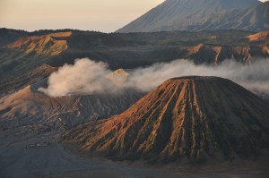
Chile , Planchon-Peteroa :
Seismology
Seismological activity during this period was characterized by:
238 VT-type earthquakes, associated with rock fracturing (volcano-tectonics). The most energetic earthquake, with a local magnitude (LM) of 2.1, was located 5.4 km east-northeast of the active crater, at a depth of 4.2 km.
47 LP-type earthquakes, associated with fluid dynamics within the volcanic system (Long Period). The magnitude of the strongest earthquake, evaluated using the reduced displacement (RD) parameter, was 16 cm².
One TR-type earthquake, associated with sustained fluid dynamics within the volcanic system (TRemor). The magnitude of the earthquake, evaluated using the reduced displacement (RD) parameter, was 2.5 cm².
Fluid Geochemistry
No atmospheric sulfur dioxide (SO2) emission anomalies have been reported near the volcanic complex, according to data published by the Tropospheric Monitoring Instrument (TROPOMI) and the Sulfur Dioxide Group of the Ozone Monitoring Instrument (OMI).
Geodesy
No changes in radar interferometry results were observed for interferograms whose images were available up to May 29, based on short-term (6 days) and medium-term (5 months) analyses.
Therefore, the system remains stable from a geodetic perspective.

Satellite Thermal Anomalies
In May, no thermal alerts attributable to volcanic activity were recorded, according to the Mid-Infrared Volcanic Activity Observation, reported by MIROVA. At the same time, no other thermal radiance anomalies were identified through analytical processing of Sentinel 2-L2A satellite images, using false-color band combinations.
Surveillance Cameras
Images provided by fixed cameras installed near the volcanic complex did not record any degassing plumes or variations related to surface activity.
Satellite Geomorphological Analysis
According to the analysis of Planet Scope and Sentinel 2 L2A satellite images, no morphological changes or recent activity features were identified. No morphological variations attributable to volcanic activity were recorded during this period. Activity remained at levels considered low, suggesting stability of the group.
The technical volcanic alert remains in effect:
GREEN TECHNICAL ALERT: Active volcano with stable behavior – No immediate risk.
Note: Given the characteristics of this volcanic system, sudden, unpredictable, low-magnitude explosions affecting the immediate vicinity of active craters cannot be ruled out. No such event has been recorded in the last four years, suggesting a low probability of occurrence within the context of a baseline activity level. Risks associated with this minor activity include the ejection of ballistic pyroclasts, ash emission, and the release of volcanic gases.
Source et photo : Sernageomin
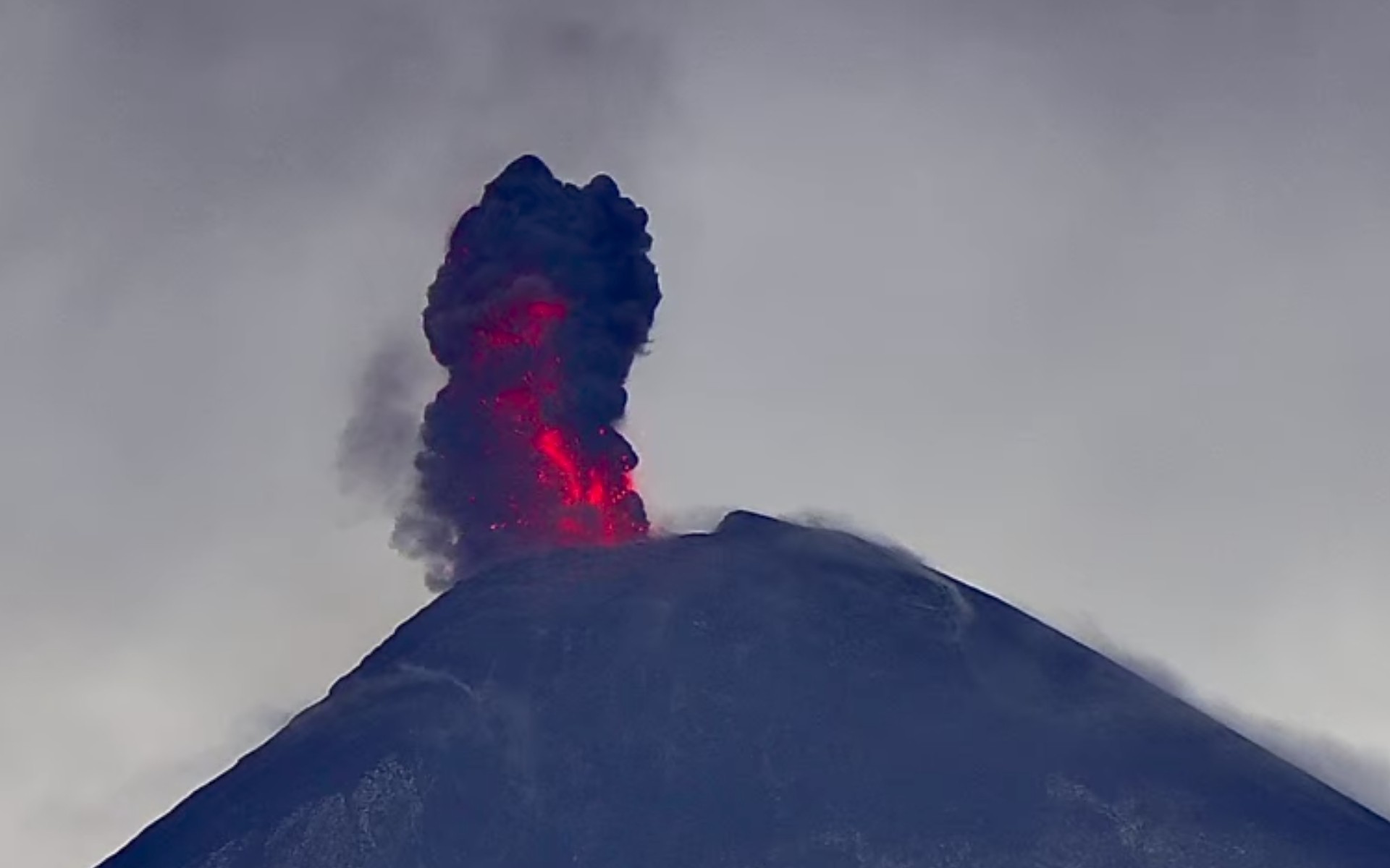
Ecuador , Sangay :
DAILY STATUS REPORT OF SANGAY VOLCANO, Saturday, June 7, 2025.
Information Geophysical Institute – EPN.
Surface Activity Level: High, Surface Trend: No Change
Internal Activity Level: Moderate, Internal Trend: No Change
Seismicity: From June 6, 2025, 11:00 a.m. to June 7, 2025, 11:00 a.m.:
Seismicity:
Below is the count of seismic events recorded at the reference station.
Explosion (EXP): 40
Rainfall/Lahars:
Since yesterday afternoon, no rain has been recorded in the volcano area. **Heavy rains could remobilize accumulated material, generating mud and debris flows that would cascade down the volcano’s flanks and flow into adjacent rivers**.
Emission/Ash Column:
Meteorological conditions did not allow for the observation of gas and/or ash emissions via the camera network. However, the GOES-19 satellite system observed an emission of gas and ash at a height of nearly 800 meters above the crater level, in a westerly direction. Regarding this activity, the Washington-based VAAC agency issued two reports of ash emissions at heights of 1,200 meters above the crater level, in a westerly direction.
Gas:
The MOUNTS satellite system detected 80.8 tons of sulfur dioxide (SO2), measured yesterday at 2:04 p.m. (local time).
Observation:
Due to cloud cover in the area, no incandescence could be observed at the volcano.
At the time of this report, the volcano remained entirely cloudy.
Alert Level: Yellow
Source : IGEPN
Photo : Cristopher Cárdenas
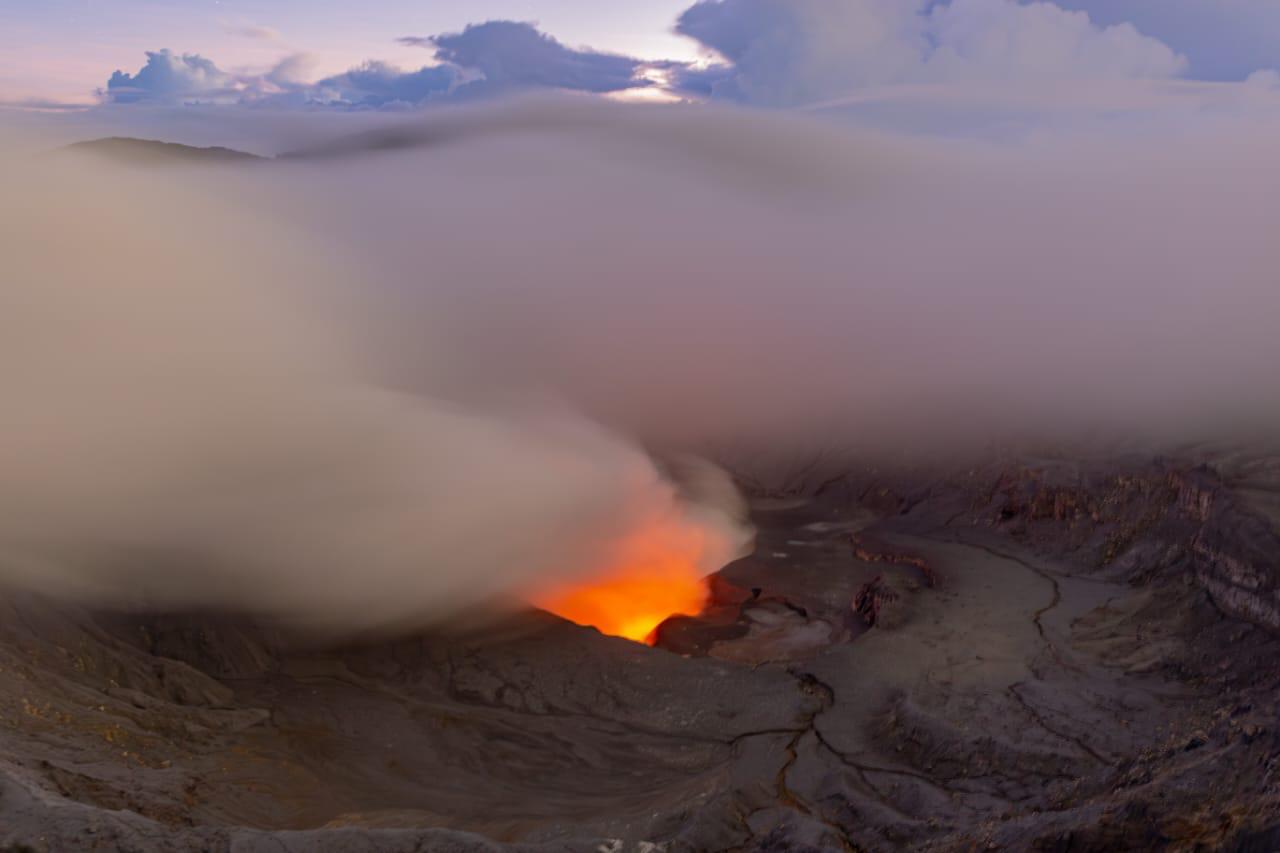
Costa Rica , Poas :
Latitude: 10.20°N;
Longitude: 84.23°W;
Altitude: 2,687 m;
Current Activity Level: Caution
Following the eruption on May 19, no further explosive events have been recorded. However, ash emissions were observed last week, particularly on June 1 and 2.
Since May 20, the amplitude of the continuous seismic tremor has remained relatively low and stable compared to previous weeks. The acoustic tremor has remained almost constant, although with some variations. An increase was notably observed on June 1, accompanying the ash emissions. The ash emissions observed this week did not exhibit a seismic signal. The number of long-period events has remained stable over the past two weeks. The number of high-frequency events decreased significantly this week. Three distal volcano-tectonic events were recorded. Geodetic monitoring has detected vertical uplift and extension of the crater crust since December 2024, with weekly variations in amplitude. Overall, ground uplift north of the crater reached 3 to 4 cm, comparable to that observed during the 2017 eruption. Last week, crater contraction was recorded without significant vertical movement.
The Poás volcano continues to emit significant quantities of magmatic gases, but a downward trend in emissions is observed. The average SO2 flux measured by the DOAS station decreased this week (230 ± 82 t/d) compared to the previous week (459 ± 46 t/d). DOAS drone transects on June 4 indicated a flux of 440 ± 70 t/d, a significant decrease compared to similar measurements made since April. The mass of SO₂ measured in the Costa Rican atmosphere by the TROPOMI sensor on the Sentinel-5P satellite showed a significant increase on May 31 and June 1, followed by a slow decrease for the remainder of the week.
Gas composition measurements are consistent with a surface magmatic source. The MultiGAS station near Boca A measured an average SO₂/CO₂ ratio of 1.7 ± 0.7, similar to the previous week. The H₂S/SO₂ ratio has been very low (< 0.1) in recent weeks. The gases are interpreted to be coming from a surface magmatic source, with no significant influence from the hydrothermal system.
Source : Ovsicori .
Photo : RSN