June 05 , 2025.
Italy / Sicily , Etna :
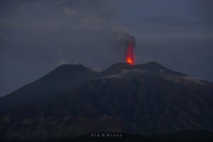
The Catania Section – Etneo Observatory (INGV) reported that the amplitude of tremors on Etna began to increase from about midnight on June 2 and reached high levels at 2:50. Infrasound activity increased slightly around 2:30 and 3:50. Strombolian activity at the Southeast Crater was visible on webcam images. The aviation color code changed to yellow (the second highest color on a four-color scale) at 3:23, to orange at 4:02, and to red at 8:39. Ash emissions at that time were limited to the summit area, although Strombolian activity intensified throughout the morning and became almost continuous. Lava overflowed the eastern rim of the crater and produced a small lava flow toward the Valle del Bove. A larger flow moved south. Infrasound activity was both frequent and intense. Lava fountaining began at the southeast crater around 10:00 a.m. and both lava flows advanced; the flows branched and reached 2 km in length. Ash plumes rose above the summit and drifted west. Minor ashfall was reported in the Piano Vetore area (6 km south-southwest) before 11:00 a.m.
Etna is often considered a « gentle » and « non-explosive » volcano, whose activity is characterized primarily by the emission of lava flows. Instead, it is an extremely versatile volcano, and especially over the last 25-30 years, the frequency of highly explosive events has increased significantly. These often manifest themselves in the form of short, very violent episodes, known as paroxysms or lava fountaining episodes, exclusively at the volcano’s summit craters, and particularly at the youngest of the four summit craters: the Southeast Crater.
For two months, from March 15 to May 12, 2025, the Southeast Crater presented us with the spectacle of small episodes of modest explosive (Strombolian) activity and lava flows. It then remained silent for three weeks, and on the morning of June 2, it erupted for the first time after a year and a half (starting on December 1, 2023).
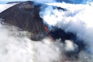
A fissure opened on the upper northeast flank of the Southeast Crater around 11:00 a.m. and produced a lava flow that advanced northward, according to the Italian Association of Vulcanology ETS (AIV ETS). Emissions of gas, ash, and white to reddish-brown steam rose from this same area. The emissions gradually intensified over a period of 20 minutes. INGV noted that at 11:24 a.m., a pyroclastic flow, likely generated by a collapse of material on the north side of the Southeast Crater cone, moved northeastward, reaching the north wall of the Valle del Leone (upper part of the Valle del Bove). The AIV ETS reported that the pyroclastic flow interacted explosively with buried snow and traveled 2 km in one minute. Ash rose along the pyroclastic flow to about 3 km above the summit and was visible throughout eastern Sicily.
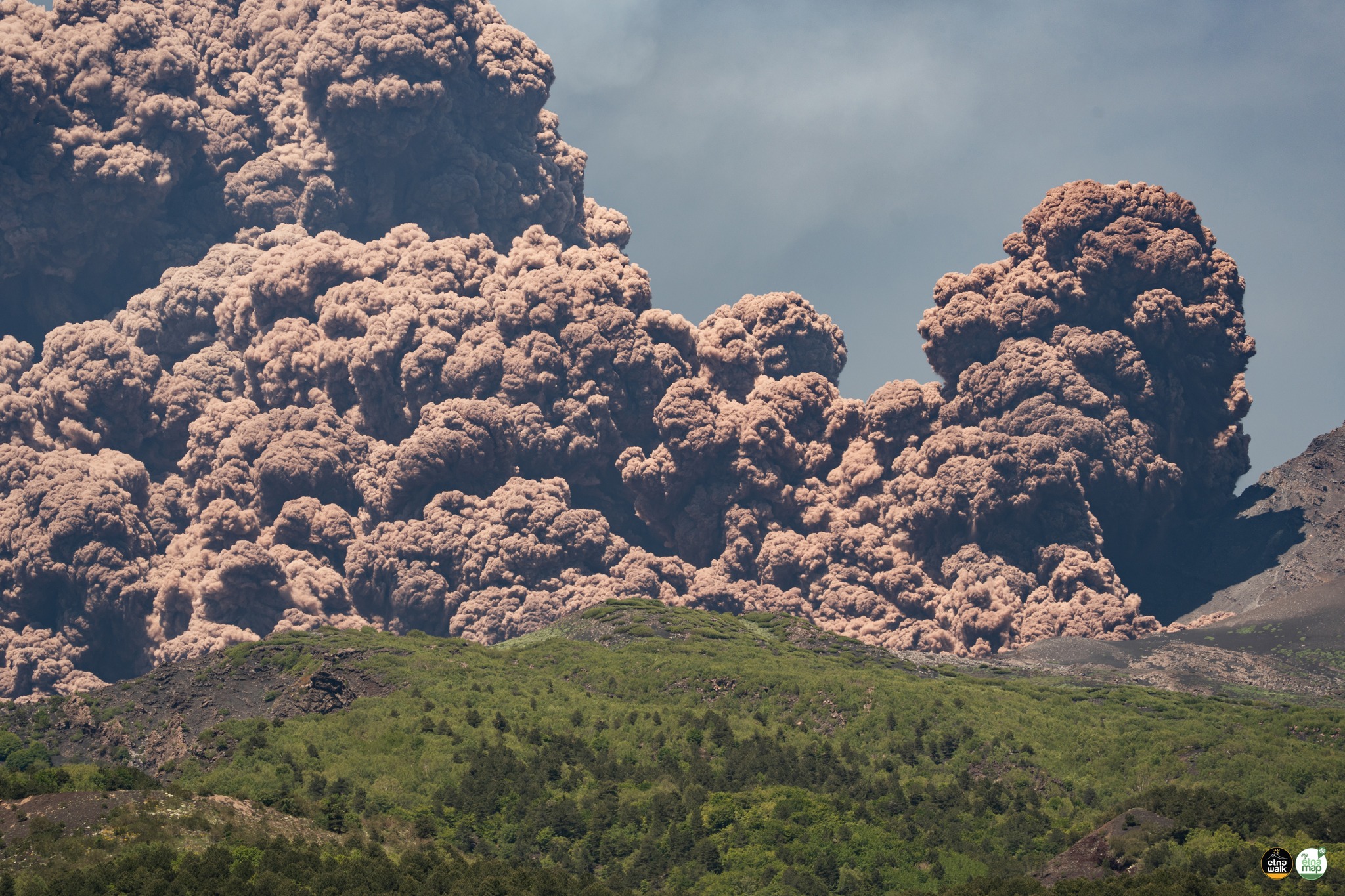
According to the INGV, fine reddish ash drifted west-northwest and fell at Cesarò (27 km west-northwest) and Bronte (15 km west-northwest). A lava flow from the base of the north flank of the southeast crater advanced northward. A press article reported that many tourists were on the flanks and were seen fleeing the pyroclastic flow; sightseeing tours of the volcano were suspended. About 20% of flights to Catania were delayed. Strombolian activity decreased in the afternoon, and at 4 p.m., the aeronautical color code was lowered to orange. Light ash emissions persisted but dispersed near the summit; The aeronautical color code was lowered to yellow at 16:56. Activity ceased and, at 20:11, the aeronautical color code was lowered to green.
Sources : Sezione di Catania – Osservatorio Etneo (INGV), Toulouse Volcanic Ash Advisory Center (VAAC), National Public Radio (NPR), New York Times, Associazione Italiana di Vulcanologia ETS (AIV ETS), GVP.
Photos : Gio Giusa , Etna Walk / Giuseppe Distefano / Marco Restivo / FB.
Commentaire : Boris Behncke / FB.
Japan , Sakurajima :
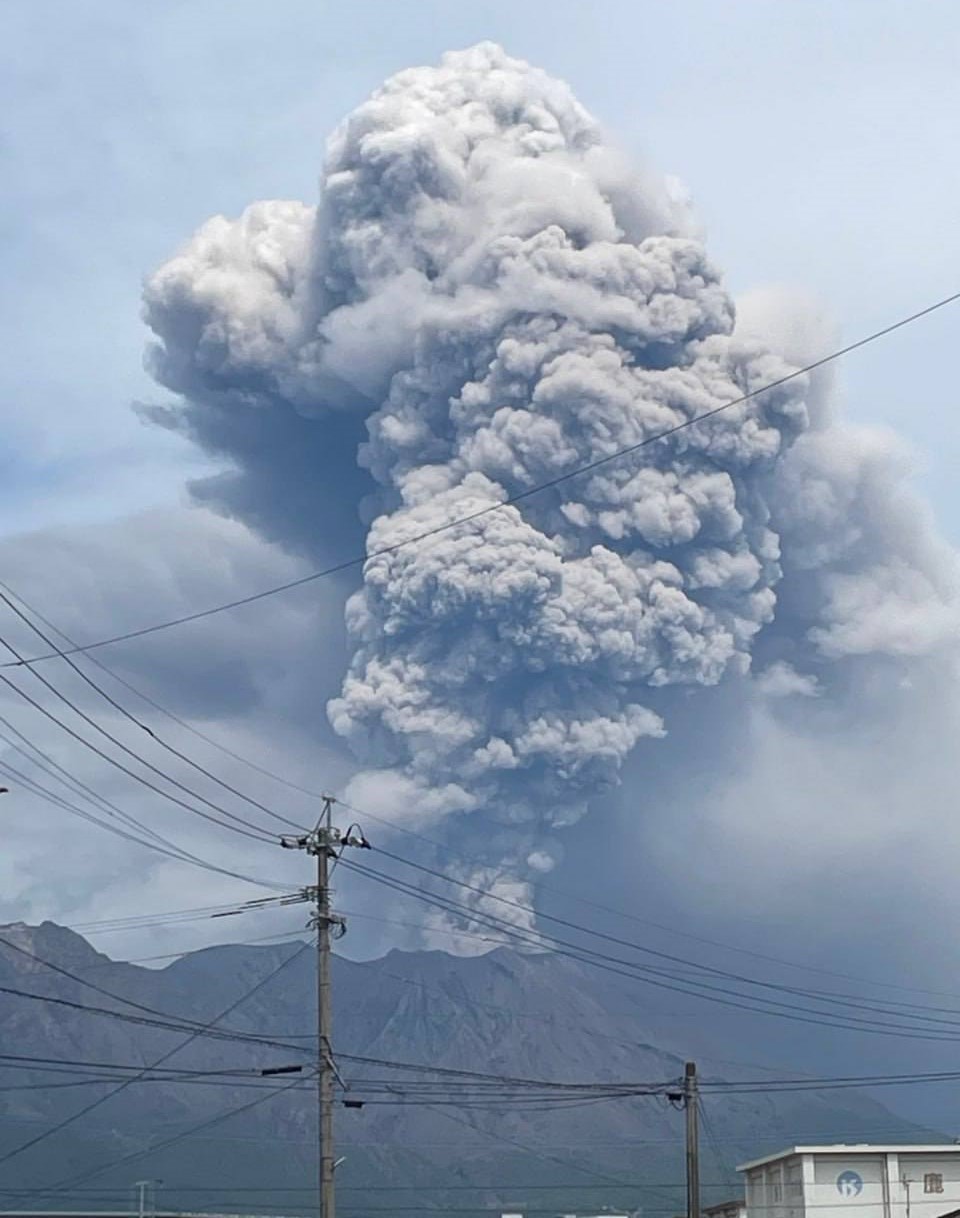
The Japan Meteorological Agency (JMA) reported ongoing eruptive activity at Minamidake Crater (Aira Caldera’s Sakurajima volcano) during 28 May-2 June. Very small eruptive events were recorded during 26-28 May. Sulfur dioxide emissions measured during a field survey on 28 May were extremely high, averaging 3,500 tons per day. An explosion at 15h37 on 29 May produced an ash plume that rose 1.5 km above the crater rim, going into weather clouds, and ejected large blocks 700 m from the rim. Nighttime crater incandescence was visible during 30 May-2 June. Explosions at 17h27 and 20h58 on 30 May and at 16h10 on 1 June generated ash plumes that rose 3-3.5 km above the crater rim and drifted S and SE and ejected large blocks as far as 1.1 km from the crater rim. An explosion at 23h41 on 2 June ejected large blocks as far as 1 km from the crater rim; details about any emissions were unknown. The Alert Level remained at 3 (on a 5-level scale), and the public was warned to be cautious within 2 km of both the Minimadake and Showa craters.
The Aira caldera in the northern half of Kagoshima Bay contains the post-caldera Sakurajima volcano, one of Japan’s most active. Eruption of the voluminous Ito pyroclastic flow accompanied formation of the 17 x 23 km caldera about 22,000 years ago. The smaller Wakamiko caldera was formed during the early Holocene in the NE corner of the caldera, along with several post-caldera cones. The construction of Sakurajima began about 13,000 years ago on the southern rim and built an island that was joined to the Osumi Peninsula during the major explosive and effusive eruption of 1914. Activity at the Kitadake summit cone ended about 4,850 years ago, after which eruptions took place at Minamidake. Frequent eruptions since the 8th century have deposited ash on the city of Kagoshima, located across Kagoshima Bay only 8 km from the summit. The largest recorded eruption took place during 1471-76.
Sources: Japan Meteorological Agency (JMA) , GVP.
Photo : via Alex Tor / FB.
Indonesia , Dieng Plateau :
INCREASE IN TEMPERATURE AND CO2 CONCENTRATION IN THE MOUNT DIENG CRATE, CENTRAL JAVA, JUNE 4, 2025.
The summit of the Dieng volcanic complex (2,565 m above sea level) is located at 7° 12′ LS and 109° 54′ BT and is administratively part of the Banjarnegara, Wonosobo, and Batang regency districts in Central Java province.
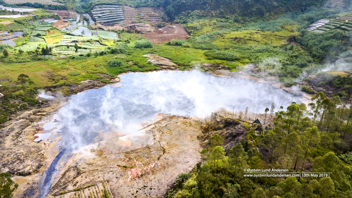
Although the seismic activity of Timbang Crater has not shown any increase, the temperature of Timbang Crater has increased for nearly a month, from 67.5 °C (May 9, 2025) to 71.5 °C on June 4, 2025. The CO2 concentration also has an increasing trend, from 0.2% on May 29, 2025 to 0.26% on June 4, 2025. Currently, the Center for Volcanology and Geological Disaster Mitigation (PVMBG), Geological Agency, continues to conduct intensive monitoring and track the development of Timbang Crater activity. In view of the increasing trend of Timbang Crater activity, PVMBG calls on the public/visitors and stakeholders to increase their vigilance and follow the current recommendations of Mount Dieng. It is also hoped that the public/farmers will become more aware of the potential flow of toxic CO2 into the valley from the Timbang crater.
Source : PVMBG
Photo : Sileri , Dieng-Plateau, Øystein Lund Andersen.
Costa Rica , Poas :
Latitude: 10.20°N; Longitude: 84.23°W; Altitude: 2,687 m
Current Activity Level: Caution
Following the May 19 eruption, no further events with ash emission or ballistic ejection have been recorded.
Since May 20, the amplitude of the continuous seismic tremor, with frequencies between 2 and 5 Hz, has remained relatively low compared to recent weeks. On May 29, harmonic tremor was observed with a dominant frequency around 1.3 Hz.
The acoustic tremor remained almost constant, with some variations, but overall of low intensity.
The number of long-period (LP) events has remained stable over the past two weeks. On May 28, six proximal volcano-tectonic (pVT) events were recorded on the northwest flank of von Frantzius cone, at a depth of approximately 5 km.
Geodetic monitoring has detected vertical uplift and extension of the crater crust since December 2024, with weekly amplitude variations. Overall, the uplift of the floor north of the crater reached 3 to 4 cm, comparable to that observed during the 2017 eruption. Last week, slight uplift and slight contraction of the crater were recorded.
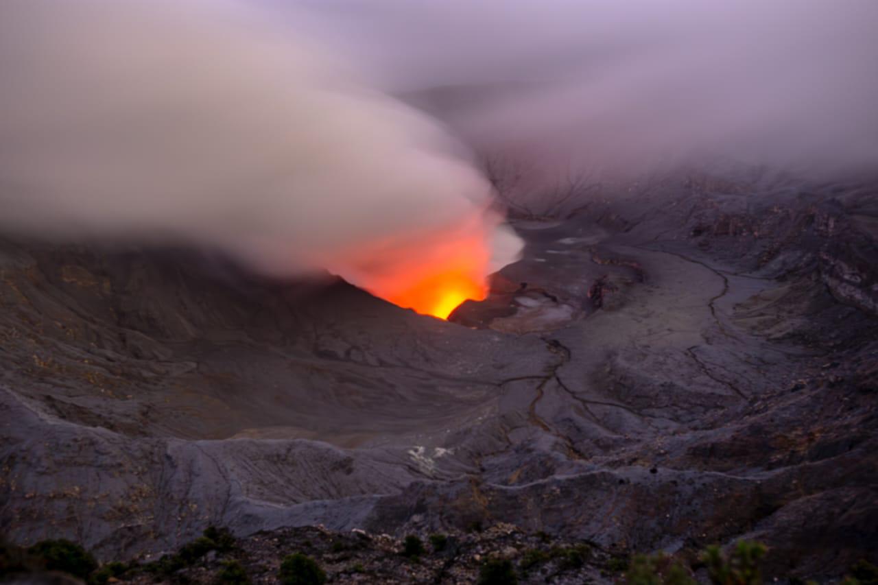
The Poás volcano continues to emit large quantities of magmatic gases, although less than during the peak degassing in late April. The average SO2 flux measured by the DOAS station increased this week (459 ± 46 t/d) compared to the previous week (309 ± 21 t/d). The Boca A gas plume is rich in SO2, as evidenced by its blue color. The mass of SO2 measured in the atmosphere of Costa Rica by the TROPOMI sensor on the Sentinel-5P satellite decreased significantly this week (approximately 89 tons on May 28, half the average compared to the previous week). Webcams continue to detect electromagnetic radiation in the infrared region (heat) and a reddish visible light at Bocas A and C. Gas composition measurements are consistent with a surface magmatic source. The MultiGAS station located near Boca A measured an average SO2/CO2 ratio of 2.2 ± 0.5, compositions very similar to those of the previous week. The H2S/SO2 ratio has been very low (< 0.1) for the past few weeks. The gases are interpreted as coming from a surface magmatic source, without significant influence from the hydrothermal system.
Source : Ovsicori .
Photo : RSN-UCR.
Hawaii , Kilauea :
Wednesday, June 4, 2025, 9:20 AM HST (Wednesday, June 4, 2025, 19:20 UTC)
19°25’16 » N 155°17’13 » W,
Summit Elevation 4091 ft (1247 m)
Current Volcano Alert Level: WATCH
Current Aviation Color Code: ORANGE
Activity Summary:
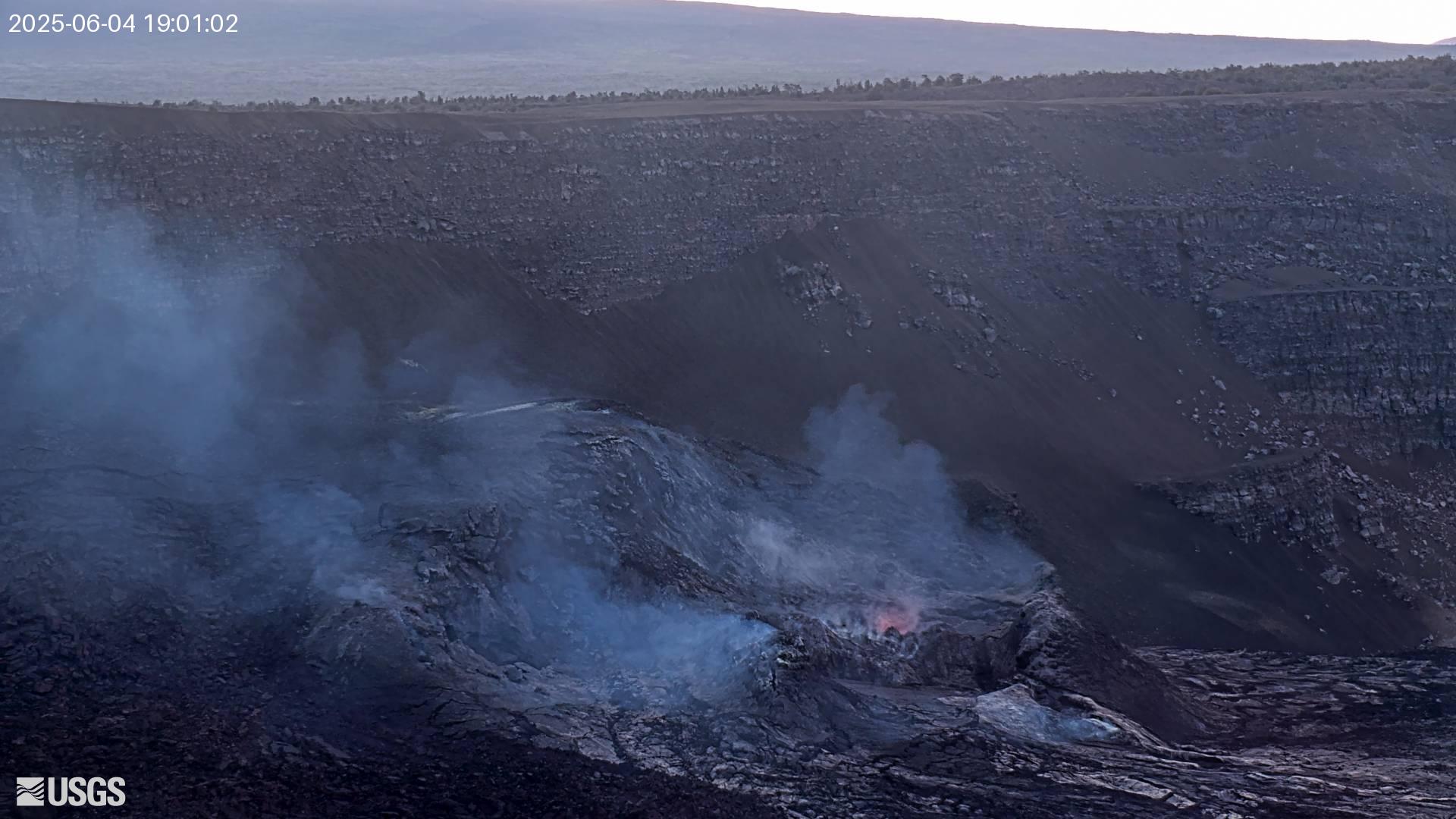
The ongoing Halema‘uma‘u eruption remains paused, but episode 24 precursory activity began yesterday morning, June 3. Summit inflation continues since the end of episode 23 on May 25, 2025. Episode 24 is most likely to begin today or tomorrow. The forecast window for the start of episode 24 began earlier this week, though it has been extended as summit inflation continues and forecast models are updated with new data. Vigorous degassing of sulfur dioxide (SO2), glow at night, and intermittent spatter indicate that magma remains close to the surface.
Fountaining episodes have occurred approximately once per week since the start of the eruption on December 23, 2024. All eruptive activity remains within Hawaiʻi Volcanoes National Park. No significant activity has been noted along Kīlauea’s East Rift Zone or Southwest Rift Zone. Current hazards include volcanic gas emissions and windblown volcanic glass (Pele’s hair) and tephra that have impacted Hawaiʻi Volcanoes National Park and nearby communities.
Summit Observations:
Episode 24 precursory low-level activity began yesterday morning. Bright glow, intermittent lava spattering, gas pistoning, and hydrogen flames were visible from the north vent overnight; though activity decreased in intensity through the night. Minimal glow was observed from the south vent. Vigorous degassing continues from both vents. The average sulfur dioxide (SO2) emission rate for inter-episode pauses is typically around 1,200 to 1,500 tonnes per day (t/d).
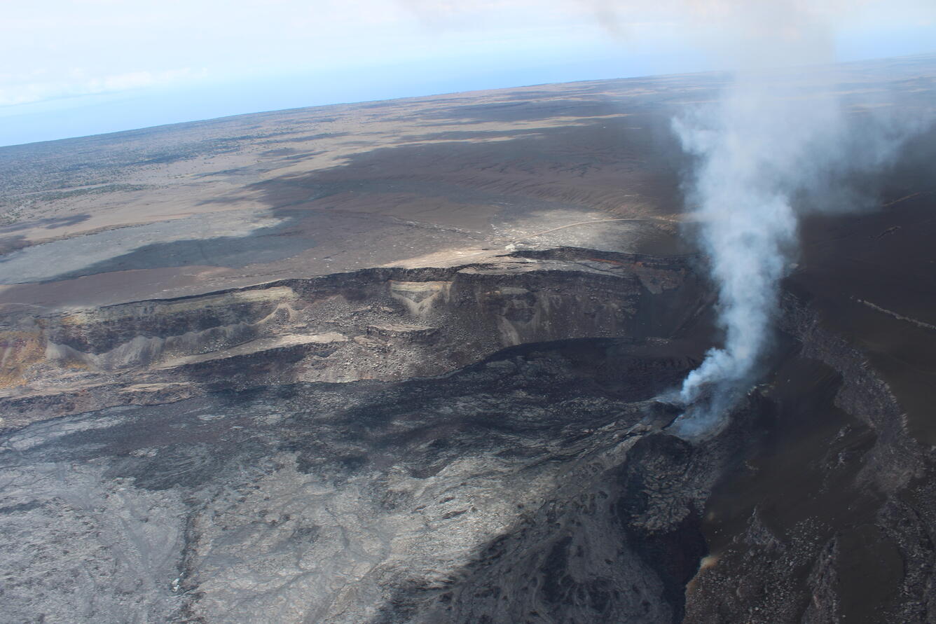
This view of the southwest portion of Halema‘uma‘u, looking to the south, was captured during a USGS Hawaiian Volcano Observatory monitoring helicopter overflight of Kīlauea volcano on Wednesday, May 28, 2025. The north and south vents are degassing on the right side of photo, with the south vent (further from the camera) degassing more strongly. Lava flows from episode 23 (silver appearance) cover most of the bottom left of the photo.
Summit inflation resumed upon cessation of fountaining on May 25. As of this morning, tiltmeters at Uēkahuna (UWD) and Sandhill (SDH) have recorded approximately 14 and 10 microradians of inflationary tilt, respectively, since the end of episode 23. This brings them back to about the same level they had at the start of episode 23. Low level seismic tremor continues beneath Halemaʻumaʻu crater.
Source : HVO.
Photo : USGS , USGS / R. Adams.