June 02 , 2025.
Italy / Sicily , Etna :
Etna Activity Report, June 2, 2025, 2:39 AM (00:39 UTC).
The National Institute of Geophysics and Volcanology, Osservatorio Etneo, reports a sudden change in monitored parameters.
June 2, 2025, 4:20 AM (02:20 UTC)
The National Institute of Geophysics and Volcanology, Osservatorio Etneo, reports that starting around 1:50 UTC, images from the monitoring system’s cameras show Strombolian activity in the southeast crater. The forecast model indicates that any eruptive clouds produced by the ongoing activity would disperse southwestward.
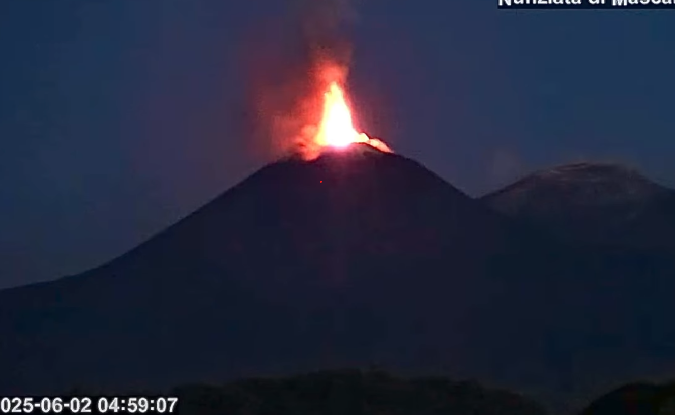
From approximately 22:00 UTC on 01/06/2025, the average amplitude of the volcanic tremor gradually increased, reaching high values around 00:50 UTC. Currently, the values are high and tend to increase. The centroid of the tremor sources is located near the southeast crater area, at an altitude of approximately 2,800 m above sea level. From approximately 00:30 UTC, a slight increase in infrasound activity is observed, localized in the area of the central craters.
No significant changes are currently observed in the deformation signals from the GNSS, inclinometer, and strainmeter networks.
Further updates will be provided shortly, and in any case within 3 hours of this press release.
Source : INGV
Photo : Capture d’écran / Weather Sicily .
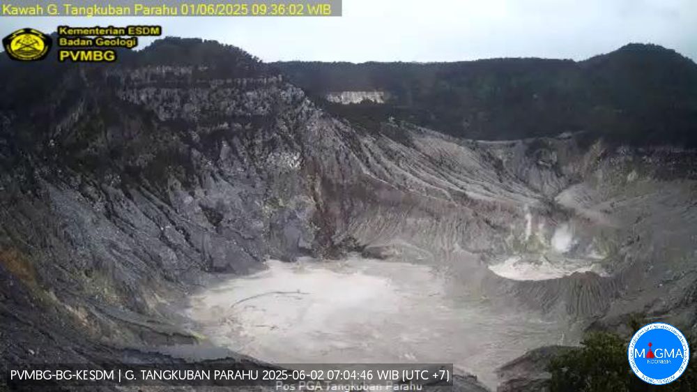
Indonesia , Tangkubanparahu :
Special Report on the Activity of Mount Tangkubanparahu, West Java, June 2, 2025.
The last eruptive activity of Mount Tangkubanparahu in 2019 began with a phreatic eruption from Ratu Crater on July 26, 2019, at 3:48 PM WIB. Until now, volcanic activity at Mount Tangkubanparahu has remained at Level I (normal), marked by white smoke escaping from Ratu Crater, of varying intensity, at a height of 5 to 110 meters above the crater base. Seismic recordings from May 30 to June 1, 2025, showed an increase in exhalation earthquakes, with a number ranging from 21 to 37, and low-frequency earthquakes, reaching 100.
Precipitation around Mount Tangkubanparahu remains high. Given the nature of the eruption at Mount Tangkubanparahu, it is more likely phreatic, caused by the contact between water and magma or hot materials within the volcano, without any magma rising to the surface. When water (groundwater, rainwater, or a crater lake) encounters hot volcanic material, very rapid heating occurs, producing high-pressure steam and triggering a phreatic eruption.
Volcanic activity at Mount Tangkubanparahu is currently dominated by low-frequency earthquakes, which indicate fluid movements at shallow depths or near the surface. The increase in low-frequency earthquakes is correlated with an increase in the intensity of gas emissions. This increase may be due to pressure variations (accumulation) at shallow depths, while no signs of pressure accumulation from deep magma have been observed.
It is important to be aware of the potential danger of a phreatic eruption, i.e., an eruption occurring without a clear or significant increase in volcanic symptoms. Phreatic eruptions, if they occur, may be accompanied by ash rain and ejections of material around the crater.
In this Level I (normal) situation, the community and visitors/tourists are advised to: (a) not approach the crater floor, not linger, and not spend the night in the area of active craters located on Mount Tangkubanparahu. (b) Immediately move away from the area around the crater if you observe an increase in the intensity or thickness of crater smoke and/or if you smell a strong odor of gas, to avoid any risk of exposure to toxic gases or phreatic eruptions.
The community around Mount Tangkubanparahu is urged to remain calm, continue their activities as usual, not be disturbed by issues related to the eruption of Mount Tangkubanparahu, and continue to monitor the progress of Mount Tangkubanparahu’s activity through the MAGMA Indonesia app.
An assessment of the activity level of Mount Tangkubanparahu will be conducted periodically or at any time in the event of a significant change. The public is urged to remain calm, vigilant, and follow the authorities’ instructions for everyone’s safety.
Source et photo : PVMBG.
Costa Rica , Rincon de la Vieja :
Latitude: 10.83°N; Longitude: 85.34°W; Altitude: 1,916 m
Current activity level: Warning.
No eruptions or exhalations were recorded this week. The frequency of tornillo-type earthquakes and long-period (LP) earthquakes continues. Since 2:00 PM yesterday, an increase in the number of low-frequency events has been recorded, and continues as of the date of this report. Some of these events have a tonal coda. The dominant frequency of tornillos in 2025 remains generally stable, with a slight downward trend over the past week. The background volcanic tremor remains of very low amplitude, with a frequency between 2.5 and 6.5 Hz; its amplitude continues to decrease compared to the past two weeks. Sporadic proximal volcano-tectonic (pVT) events and short-term tremors are recorded. Geodetic observations show a slight basal contraction. During the last week, the average SO2 flux was 83 ± 46 t/d, a level similar to that of the previous week (75 ± 35 t/d). The MultiGAS station continues to record low concentrations of volcanic gases.
Date: May 31, 2025, 3:46 PM
Plume Height (above crater):
3,000 m
Plume Observation Source: Infrasound Seismic Signal
Observed Activity:
An explosive eruption was recorded.
A white eruptive column was observed. The plume dispersed westward.
Activity Level: Caution
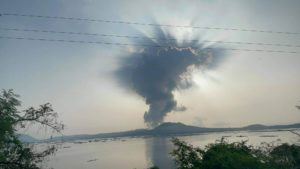
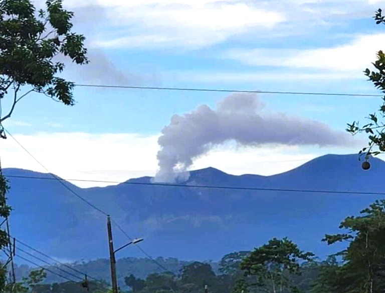
The Rincón de la Vieja volcano, located in Guanacaste, experienced an explosive eruption this Saturday afternoon, according to the Volcanological and Seismological Observatory of Costa Rica (OVSICORI-UNA).
According to the official report, the eruption occurred around 3:46 PM and produced a white column of gas and steam that reached a height of 3,000 meters above the crater (approximately 9,840 feet above sea level).
The plume dispersed towards the west, according to the official report from the authorities.
Sources : Ovsicori , Lajornadanet .
Photo : Ovsicori .
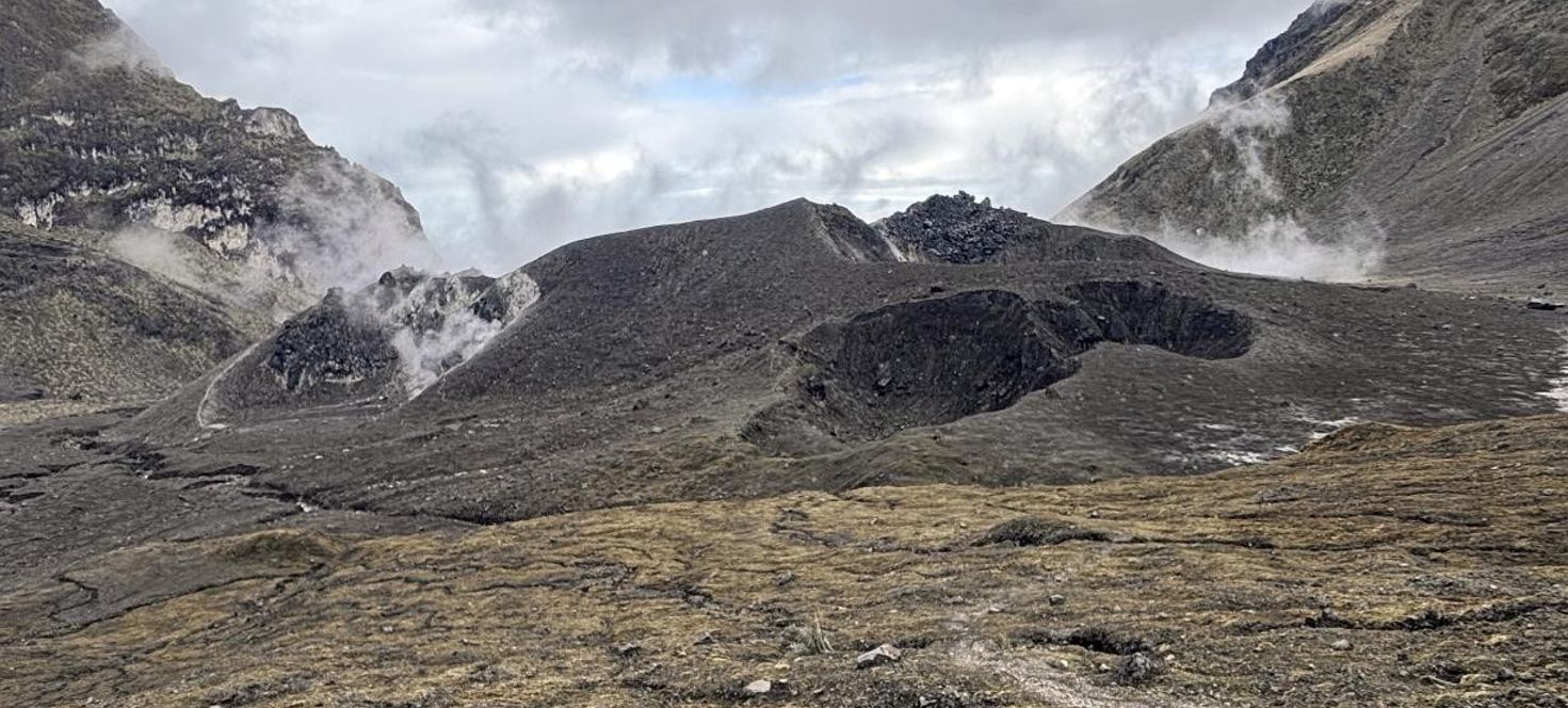
Ecuador , Guagua Pichincha :
Summary: What’s happening at the Guagua Pichincha volcano?
Since 2023, an increase in the number of seismic events has been observed at the volcano, without exceeding the levels recorded in previous periods, such as 2014 or 2016.
The inflation process at the crater floor has been ongoing since 2023 and has accumulated a deformation of approximately 6 centimeters to date. However, while this figure may seem high, it is not significantly different from the inflation rates detected in previous years.
The most striking feature is the increase in the height and intensity of gas emissions, from an average of 50 meters to over 250 meters. It is important to note that these events are not constant; these emissions are more energetic, as they can be heard from the crater rim, an area where new thermal anomalies have also appeared. These observations were already included in the 2024 annual report published in April 2025. However, on May 15, a technical team descended to the crater floor to conduct direct gas and temperature sampling and measurements. They also conducted drone overflights to obtain a comprehensive and detailed view of the volcano’s current situation.
The observed changes are slight and do not suggest an imminent eruption. We know that the processes at Guagua Pichincha are generally slow and could take several years to trigger an eruption. It is therefore important to remind the public that Guagua Pichincha is an active volcano. The continued presence of toxic gases, rockfalls, and the possibility of unpredictable phreatic explosions make access to the interior of the crater restricted.
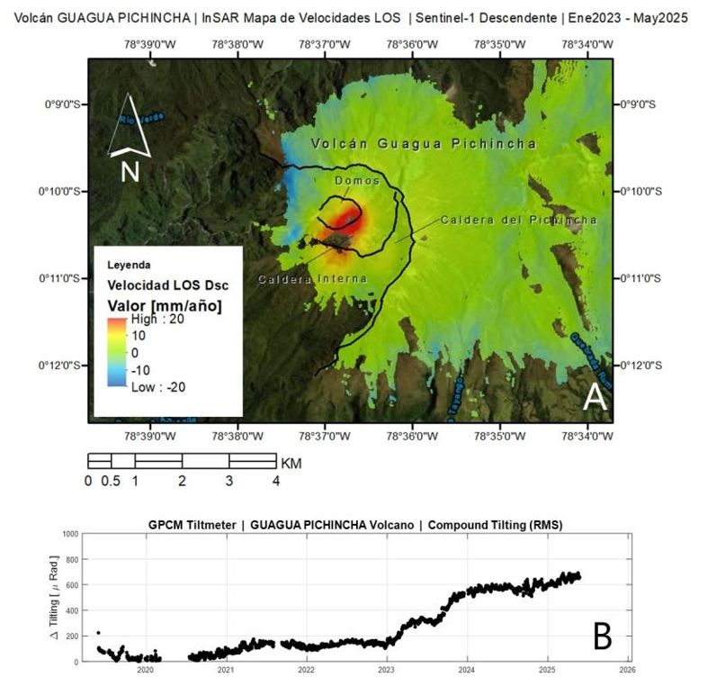
Geodesy
Using geodetic techniques, ground stations, and remote sensing, it was possible to detect deformation patterns within the volcanic crater. The deformed areas, observed by InSAR interferometry, are shown in red on the velocity map in Figure 2-A. In this area, velocities exceed 20 mm/year relative to the satellite observation line (LOS). Figure 2-B presents time series from the GPCM inclinometer sensor, located on the western rim of the GGP caldera. These data show a significant change in ground tilt starting in 2023. Between 2024 and 2025, the ascent rate slowed but continues to increase.
Recommendations
• Given the active nature of the volcano and the dangers it poses, the ban on descending to the bottom of the Guagua Pichincha volcano crater, decreed by the Ministry of Tourism and the Secretariat for Risk Management, remains in effect.
• The presence of gases potentially harmful to health, high temperature zones that can cause burns, and phreatic explosions (due to the heating and pressurization of the water) are sudden events that cannot be detected by the IG-EPN monitoring networks.
The Institute continues its ongoing monitoring and will report any relevant developments.
Source et photo : IGEPN
Guatemala , Santiaguito :
Weather Conditions: Clear sky.
Wind: Northeast.
Precipitation: 28.0 mm.
Activity:
During the night and early morning, incandescence was observed emanating from the Caliente Dome. The seismic and acoustic sensor monitoring network identified degassing pulses, forming thick gas columns, as well as weak explosions causing periods of increased incandescence and ash columns reaching up to 3,500 meters above sea level. This explosive activity was accompanied by avalanches in east, south, and southeast directions.

Ash may disperse 15 to 40 km to the west and southwest, causing fine ashfall on farms and communities near the volcano. The Santiaguito volcano remains very active; the occurrence of moderate to strong ash and boulder flows cannot be ruled out, as well as possible long-distance pyroclastic flows in different directions. Therefore, the recommendations of special bulletin BESAN-002-2025 should be followed. In the event of rain on the volcanic complex, lahars may occur; it is therefore recommended to consult the recommendations of special bulletin BESAN-012-2025.
Source : Insivumeh.
Photo : Explorandoguatemala .