May 30 , 2025.
Hawaii , Kilauea :
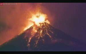
Episode 23 lava fountains erupted continuously for six hours and reached heights of about 1,150 feet (350 meters). These were the highest lava fountains observed so far during the current eruption, which began on December 23, 2024. An impressive blanket of tephra—volcanic rock fragments carried into the air—was deposited beneath and downwind of these fountains, primarily in the upper part of Kīlauea’s Southwest Rift Zone in the closed area of Hawaiʻi Volcanoes National Park.
This episode also had the highest gas plume seen thus far in this eruption sequence. The plume reached heights of more than 20,000 feet (6,100 meters)—and likely over 25,000 feet (7,600 meters)—above Kīlauea’s summit, which is at an elevation of about 4,000 feet (1,200 meters) above sea level. The plume contained high levels of water vapor (H2O), carbon dioxide (CO2), and sulfur dioxide (SO2).
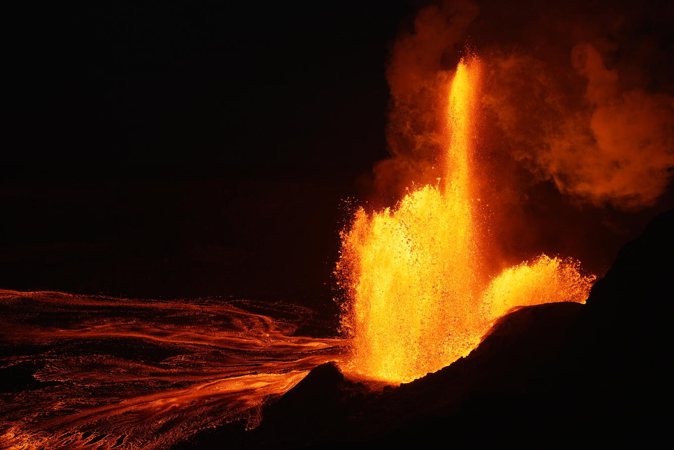
Episode 23 at the summit of Kīlauea included lava fountaining from both the south and north vents. The tall narrow finger of lava shown here, as well as the lower fountaining to the right, are both sourced from the south vent, while the wider fountain originates from the north vent.
These record-setting fountain and plume heights were reached quickly, less than one hour after episode 23 started. Following an extended period of gradual inflation and precursory low-level activity, episode 23 began at 4:15 p.m. with thin jets of lava erupting from the north vent. Fountaining became more vigorous around 4:25 and then escalated quickly and dramatically around 4:36 p.m. as tremor intensified and gradual inflation switched to rapid deflation. North vent fountains approached 1,000 feet (300 meters) in height by 5:00 p.m. and peaked just after 5:30 p.m. South vent fountaining began at 5:20 p.m. and reached heights of 600–800 feet (180–250 meters) by 6:30 p.m. that were sustained until the final hour of the episode.
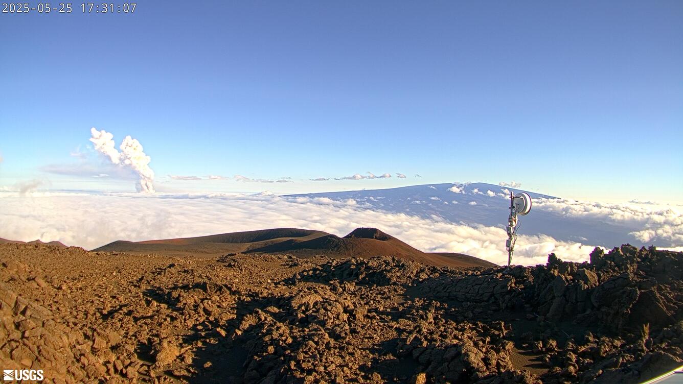
The Kīlauea plume from episode 23 reached heights of more than 20,000 feet (6,100 meters)— likely over 25,000 feet (7,600 meters)—above Kīlauea’s summit, which is at an elevation of about 4,000 feet (1,200 meters) above sea level. This photo, taken from Mauna Kea and looking south, shows Mauna Loa in the right side of the photo and the Kīlauea plume rising above the clouds in the left side of the photo. The plume contained high levels of water vapor (H2O), carbon dioxide (CO2), and sulfur dioxide (SO2).
Episode 24 will likely begin within the coming week. Kīlauea’s summit is currently reinflating and magma remains close to the surface within the north and south vent conduits. During a helicopter overflight on May 28, USGS Hawaiian Volcano Observatory (HVO) scientists could see lava churning away at a depth of a few tens of yards (meters) within the north vent conduit. Strong orange glow from the vents is visible at night on HVO webcams and from public viewing areas in Hawai’i Volcanoes National Park.
Source : HVO.
Photos : USGS / M. Patrick , webcam USGS.
Japan , Kirishimayama :
The Japan Meteorological Agency (JMA) reported that increased unrest at Shinmoedake (Shinmoe peak, a stratovolcano of the Kirishimayama volcano group) during March through early May had stabilized. Volcanic earthquakes with epicenters beneath Shinmoedake began to increase on 28 March and tiltmeter data indicated inflation on 30 March. During 22-26 April minor NW tilt was observed in inclinometer data and the number of earthquakes further increased. Volcanic tremor was detected on 27 April and during 1-2 May. During the first half of May seismicity remained high but did not significantly increase, and there were no changes detected in tiltmeter data. At 1100 on 27 May the Alert Level was lowered to 2 (on a 5-level scale) and the public was warned to exercise caution within 2 km from Shinmoedake Crater.
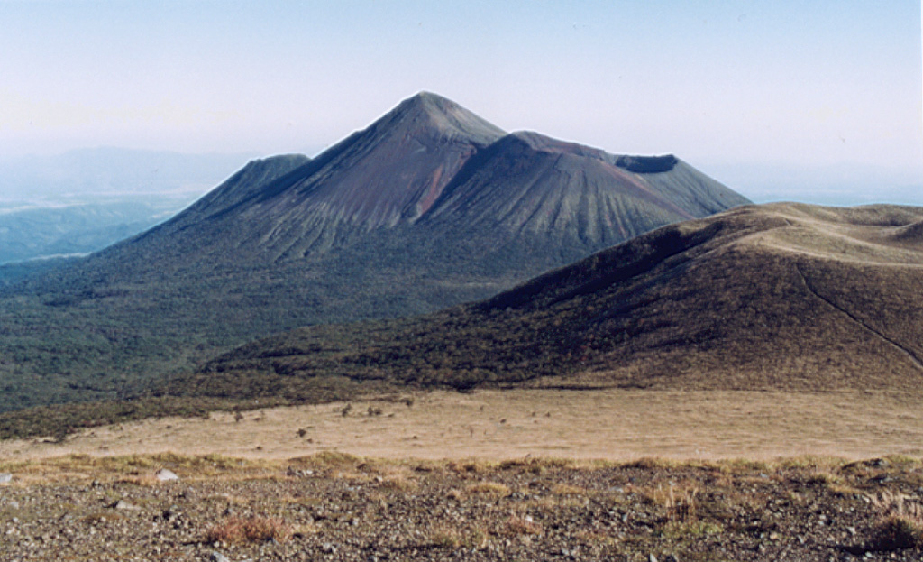
Kirishimayama is a large group of more than 20 Quaternary volcanoes located north of Kagoshima Bay. The late-Pleistocene to Holocene dominantly andesitic group consists of stratovolcanoes, pyroclastic cones, maars, and underlying shield volcanoes located over an area of 20 x 30 km. The larger stratovolcanoes are scattered throughout the field, with the centrally located Karakunidake being the highest. Onamiike and Miike, the two largest maars, are located SW of Karakunidake and at its far eastern end, respectively. Holocene eruptions have been concentrated along an E-W line of vents from Miike to Ohachi, and at Shinmoedake to the NE. Frequent small-to-moderate explosive eruptions have been recorded since the 8th century.
Sources: Japan Meteorological Agency (JMA) , GVP.
Photo : GVP ( Ichio Moriya (Kanazawa University).
Philippines , Kanlaon :
The Philippine Institute of Volcanology and Seismology (PHIVOLCS) reported continuing unrest at Kanlaon during 20-26 May. The seismic network recorded 1-31 daily volcanic earthquakes. Daily sulfur dioxide emissions ranged from 653 to 1,836 tonnes per day. Gas-and-steam emissions generally rose 75-700 m above the crater rim and drifted NW, W, SW, and SSW. According to Civil Defense PH, heavy rain on 22 May generated lahars that overflowed the Tamburong creek at the Tamburong Bridge in Barangay Biaknabato. The lahar deposits, consisting of mud and volcanic debris, blocked the Biaknabato Bridge and a portion of the Biaknabato Highway in La Castellana. The Alert Level remained at 3 (on a scale of 0-5); the public was warned to stay 6 km away from the summit and pilots were warned not to fly close to the volcano.
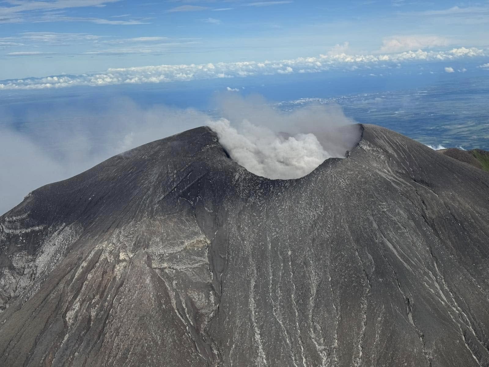
Kanlaon volcano (also spelled Canlaon) forms the highest point on the Philippine island of Negros. The massive andesitic stratovolcano is covered with fissure-controlled pyroclastic cones and craters, many of which are filled by lakes. The largest debris avalanche known in the Philippines traveled 33 km SW from Kanlaon. The summit contains a 2-km-wide, elongated northern caldera with a crater lake and a smaller but higher active vent, Lugud crater, to the south. Eruptions recorded since 1866 have typically consisted of phreatic explosions of small-to-moderate size that produce minor local ashfall
Sources: Philippine Institute of Volcanology and Seismology (PHIVOLCS), Office of Civil Defense, Republic of the Philippines , GVP
Photo : Gma news
Indonesia , Kelud :
SPECIAL REPORT, MAY 29, 2025.
On May 29, 2025, a video circulated on social media reporting an eruption of the Kelud Volcano in East Java, accompanied by lightning, around 6:30-7:30 PM WIB. The phenomenon was reportedly observed in Blitar Regency. According to the results of the verification conducted by the Kelud Volcano Observation Post, the seismic data from the seismograph did not record any eruptive activity from the Kelud Volcano, and even the lightning observed in the video was not recorded.
Visual monitoring from the volcano observation post showed a fairly thick cloud formation, accompanied by rain and lightning, to the north or northwest of the Kelud Volcano. Thus, the video recording circulated on social media from Blitar Regency was simply a meteorological phenomenon and had no connection to the activity of Mount Kelud. It is certain that the video announcing an eruption of Mount Kelud is fake or fraudulent.
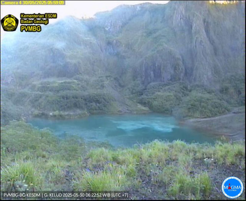
The activity level of Mount Kelud, located in East Java province, is currently Level I (normal). Seismic data recorded at the Kelud Volcano Observation Post last week (May 22–29, 2025) recorded one deep volcanic earthquake, two local tectonic earthquakes, and 16 distant tectonic earthquakes. The volcano is clearly visible until it is covered by fog. No smoke from the crater is observed. The weather is sunny to rainy, with light to strong winds.
Therefore, the public and stakeholders are advised not to pay attention to rumors regarding the eruption of Mount Kelud and to always coordinate with the Kelud PGA Post in Sugihwaras Village, Ngancar District, Kediri Regency, or the Volcanology and Geological Disaster Mitigation Center of the Bandung Geological Agency for information on the activity of Mount Kelud.
Source et photo : PVMBG.
Costa Rica , Poas :
Latitude: 10.2
Longitude: -84.233
Altitude: 2,687 meters
Observed Activity:
Background seismic and acoustic tremors are stable and of low amplitude.
Yesterday, several volcano-tectonic earthquakes were recorded in the northwest sector of the volcano.
Another low-frequency tremor signal (~1.3 Hz), not observed in previous days, was observed.
Long-period (LP) seismic events were recorded.
Infrared electromagnetic radiation was observed last night at Vent A (observed since mid-April).
Activity Level: Caution (3)
The Observatorio Vulcanológico y Sismológico de Costa Rica-Universidad Nacional (OVSICORI-UNA) reported continuing gas-and-steam emissions at Poás during 21-27 May; ash content of the plumes was either very low or not present. Sulfur dioxide gas emissions remained at high levels, though they had decreased compared to the previous week. The emissions detected in satellite data drifting SW on 20 May were estimated to be 598 tonnes per day (t/d).
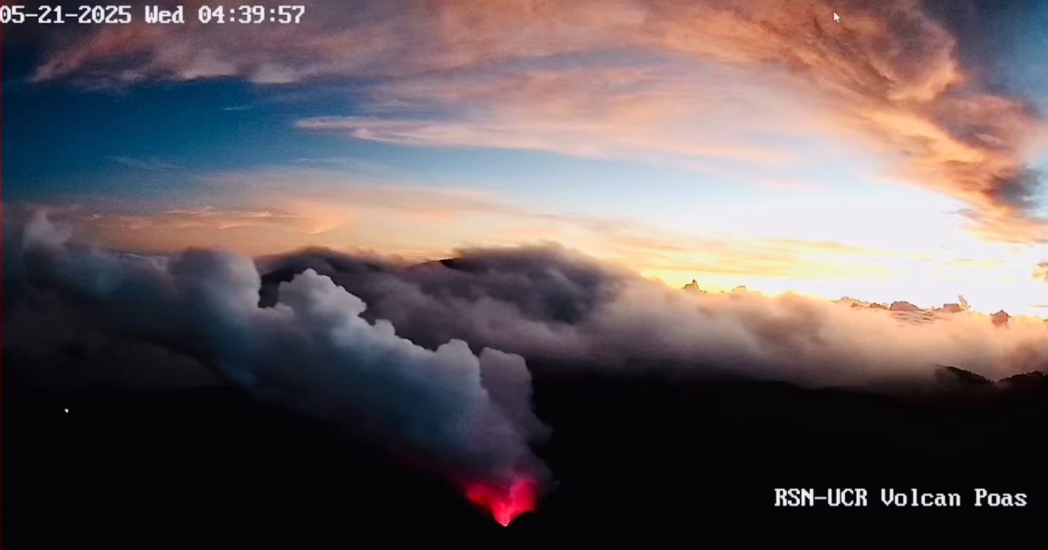
The fixed Differential Optical Absorption Spectroscopy (DOAS) station recorded slightly lower averages compared to the previous week, averaging around 309 t/d during 17-23 May, and a transect using a mobile DOAS instrument recorded 3,000 t/d on 22 May, similar to the previous week. Intense incandescence continued to be visible at both Boca A and Boca C vents. On 21 May the temperature at Boca A was measured with an infrared sensor mounted on a drone, revealing a maximum temperature of 470 degrees Celsius. Water continued pooling at Boca C. Pulses in acoustic data during 26-27 May likely originated from bubbling at Boca C. The volcano’s Alert Level remained at 3 (the second highest level on a four-level scale).
Sources : Observatorio Vulcanologico y Sismologico de Costa Rica-Universidad Nacional (OVSICORI-UNA), GVP.
Photo : RSN UNA.