May 17 , 2025 .
Hawaii , Kilauea :
Friday, May 16, 2025, 6:17 AM HST (Friday, May 16, 2025, 16:17 UTC)
19°25’16 » N 155°17’13 » W,
Summit Elevation 4091 ft (1247 m)
Current Volcano Alert Level: WATCH
Current Aviation Color Code: ORANGE
Activity Summary:
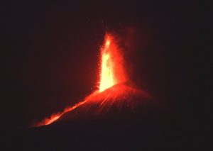
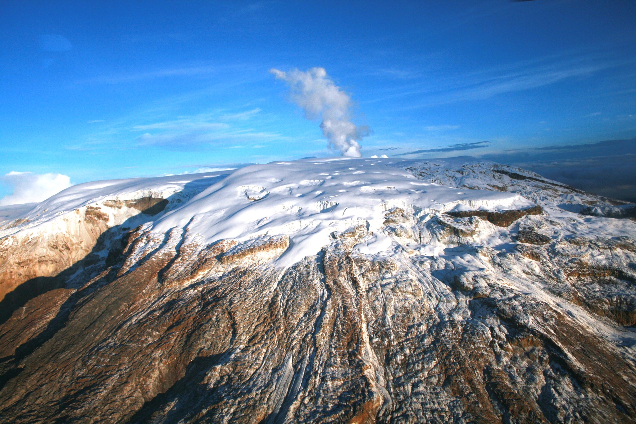
Eruption of episode 22 high fountains began at 5:13 a.m. HST on May 16, 2025. Fountains from the north vent have reached maximum heights of up to 300 meters (1000 feet).
Episode 22 was preceded by small, sporadic gas-piston events that produced spatter fountains and short lava flows that began at 10:45 p.m. HST on May 15. Five more gas piston overflows occurred in the early morning of May 16 (00:30; 1:00; 1:25; 1:54; 2:43 a.m. HST) until 4:40 a.m. when dome fountains overflowed the vent. By 5:13 sustained high fountaining began. Sustained fountains from the north vent peaked at 800-1000 feet (200-300 meters) high around 6:00 a.m. HST and began to oscillate in height around 328-492 feet (100-150 meters) after this time. Fountains are feeding multiple lava streams at 6:10 a.m. HST. At this time, approximately 30-40% of Halema‘uma‘u has been covered with lava flows.
Inflationary tilt reached just over 7 microradians since the end of the last episode. Seismic tremor began increasing and tilt at UWD switched from inflation to deflation at about 5:13 a.m. HST, about the same time that high fountains were sustained.
Most episodes of Halemaʻumaʻu lava fountaining since December 23, 2024, have continued for around a day or less and have been separated by pauses in eruptive activity lasting generally at least several days.
No changes have been detected in the East Rift Zone or Southwest Rift Zone. HVO continues to closely monitor Kīlauea and will issue an eruption update tomorrow morning unless there are significant changes before then.
Kīlauea Volcano Alert Level/Aviation Color Code remain at WATCH/ORANGE. All current and recent activity is within Hawaiʻi Volcanoes National Park.
Friday, May 16, 2025, 3:55 PM HST (Saturday, May 17, 2025, 01:55 UTC)
Activity Summary:
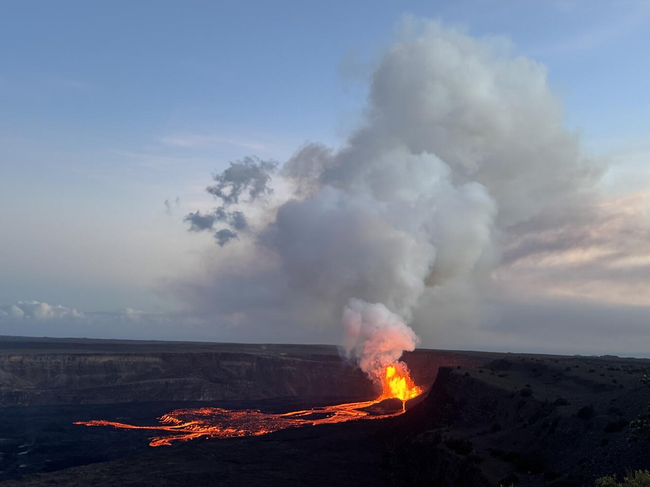
Episode 22 of the ongoing Halemaʻumaʻu eruption ended abruptly at 3:29 p.m. HST on May 16.
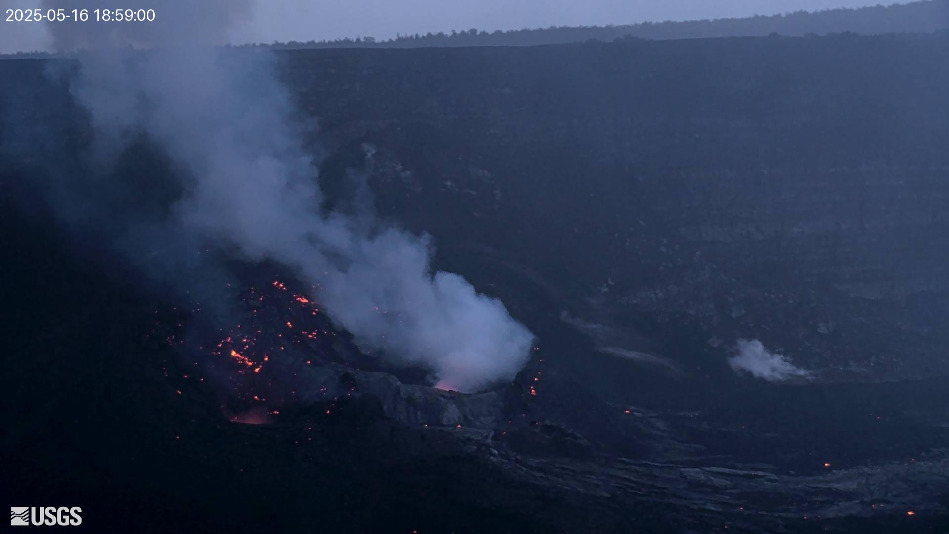
The north vent stopped erupting at 3:29 p.m. HST after 10 hours and 16 minutes of high fountains (10 hours of 46 minutes of continuous eruption). Lava flows from this episode covered about 40% of the floor of Halemaʻumaʻu within Kaluapele (Kīlauea caldera). The estimated volume of erupted lava is 3.8 million cubic meters (5 million cubic yards).
Deflationary tilt at the summit recorded about 10 microradians during this episode. The end of the eruption was coincident with a rapid change from deflation to inflation at the summit and a decrease in seismic tremor intensity.
Most episodes of Halemaʻumaʻu lava fountaining since December 23, 2024, have continued for around a day or less and have been separated by pauses in eruptive activity lasting generally at least several days.
Source : HVO
Photos : USGS / M. Patrick.
Alaska , Spurr :
Unrest continues at Mount Spurr. The level of unrest is still above background, but lower than observed in early 2025. The likelihood of an eruption has declined since March, but explosive eruptions like those in 1953 and 1992 are still possible. Should unrest escalate, we expect seismicity at higher levels than present, lasting weeks or months, more robust gas emissions, and higher deformation rates.
Earthquakes detected at the volcano are smaller than those caused by tectonic activity and cannot be felt. During the past week, 92 earthquakes were located with most of the quakes smaller than Magnitude 1. This is an increase in located earthquakes compared to the previous eight weeks. Smaller quakes that cannot be located also occur several times per hour. Ground deformation at Mount Spurr has slowed over the past month, like the pause that occurred for several weeks in November and December 2024. Although it has slowed over the past month, an increase in observed deformation over the past week is likely due to seasonal effects.
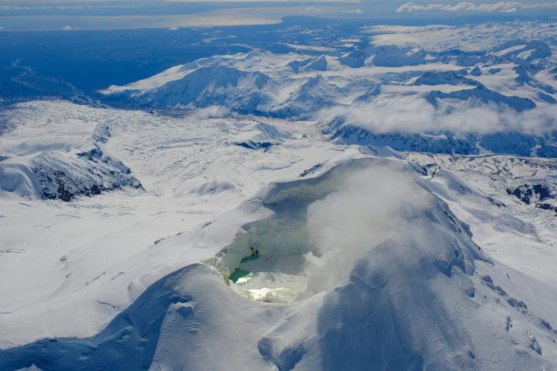
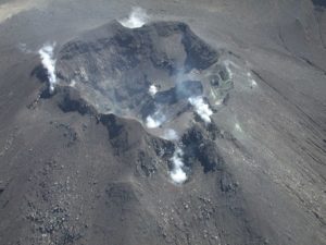
Views of the summit from local web cameras showed a vapor plume when viewing conditions were clear. No significant surface changes were observed at Crater Peak. Weak sulfur dioxide emissions were detected several times in satellite data this week when clouds did not obscure the volcano summit. An AVO field crew serviced multiple geophysical stations this week to clear snow and improve data transmission.
AVO continues to closely monitor activity at Mount Spurr for signals indicating the volcano is moving closer to an eruption using local seismic, infrasound, and GNSS (GPS) stations, web cameras, airborne and satellite gas measurements, regional infrasound, lightning networks, and satellite images. Based on previous eruptions, additional changes in earthquakes, ground deformation, the summit lake, and fumaroles would be expected if magma moves closer to the surface. Therefore, if an eruption occurred, it would be preceded by additional signals allowing advance warning.
Source : AVO.
Photo : Loewen, Matt / AVO/USGS
Kamchatka , Sheveluch :
VOLCANO OBSERVATORY NOTICE FOR AVIATION (VONA)
Issued: May 17 , 2025
Volcano: Sheveluch (CAVW #300270)
Current aviation colour code: ORANGE
Previous aviation colour code: orange
Source: KVERT
Notice Number: 2025-30
Volcano Location: N 56 deg 38 min E 161 deg 18 min
Area: Kamchatka, Russia
Summit Elevation: 3283 m (10768.24 ft), the dome elevation ~2500 m (8200 ft)
Volcanic Activity Summary:
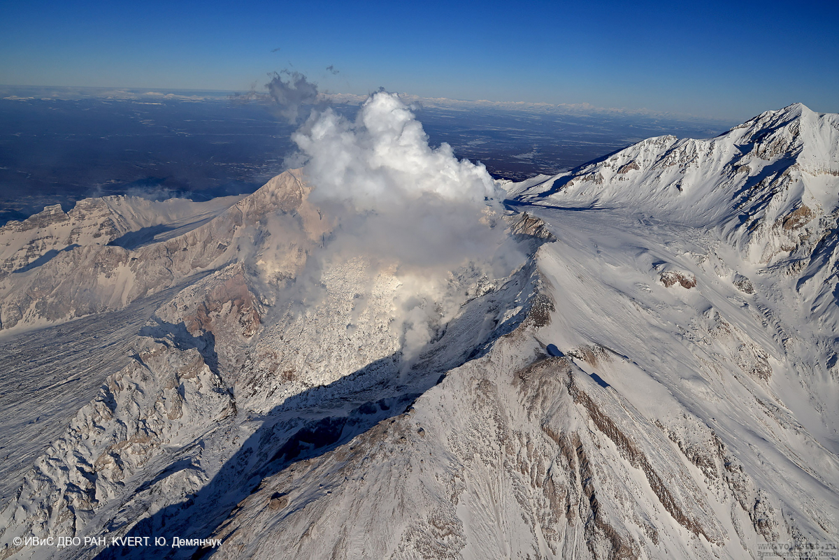
An extrusive-effusive eruption of the Young Sheveluch volcano continue. According to satellite data by KVERT, explosions sent ash up to 8.5 km a.s.l., and an ash cloud continues to move about 150 km (at 01:50 UTC) to the north-northwest of the volcano.
An extrusive-effusive eruption of the volcano continues. Ash explosions up to 10 km (32,800 ft) a.s.l. could occur at any time. Ongoing activity could affect international and low-flying aircraft.
Volcanic cloud height:
8500 m (27880 ft) AMSL Time and method of ash plume/cloud height determination: 20250517/0020Z – Himawari-9 14m15
Other volcanic cloud information:
Distance of ash plume/cloud of the volcano: 35 km (22 mi)
Direction of drift of ash plume/cloud of the volcano: NNE / azimuth 28 deg
Time and method of ash plume/cloud determination: 20250517/0020Z – Himawari-9 14m15
Source : Kvert
Photo : Yu. Demyanchuk. IVS FEB RAS, KVERT
Indonesia , Marapi :
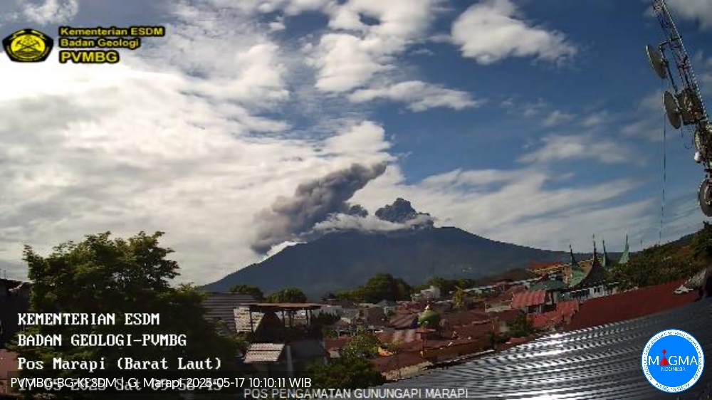
An eruption of Mount Marapi occurred on Saturday, May 17, 2025, at 09:54 WIB with an observed ash column height of ± 1000 m above the peak (± 3891 m above sea level). The ash column was observed to be gray in color with a thick intensity, oriented toward the northeast. This eruption was recorded on a seismograph with a maximum amplitude of 30.4 mm and a duration of 51 seconds.
VOLCANO OBSERVATORY NOTICE FOR AVIATION – VONA
Issued : May 17 , 2025
Volcano : Marapi (261140)
Current Aviation Colour Code : ORANGE
Previous Aviation Colour Code : yellow
Source : Marapi Volcano Observatory
Notice Number : 2025MAR044
Volcano Location : S 0 deg 22 min 52 sec E 100 deg 28 min 23 sec
Area : West Sumatra, Indonesia
Summit Elevation : 9251 FT (2891 M)
Volcanic Activity Summary :
Eruption with volcanic ash cloud at 02h54 UTC (09h54 local).
Volcanic Cloud Height :
Best estimate of ash-cloud top is around 12451 FT (3891 M) above sea level or 3200 FT (1000 M) above summit. May be higher than what can be observed clearly. Source of height data: ground observer.
Other Volcanic Cloud Information :
Ash cloud moving from north to northeast. Volcanic ash is observed to be gray. The intensity of volcanic ash is observed to be thick.
Remarks :
Eruption recorded on seismogram with maximum amplitude 30.4 mm and maximum duration 51 second.
Source et photo : Magma Indonésie .
Colombia , Nevado del Ruiz :
Manizales, May 13, 2025, 6:00 p.m.
Monitoring the activity of the Nevado del Ruiz volcano, the Colombian Geological Survey (SGC), an entity affiliated with the Ministry of Mines and Energy, reports that:
During the week of May 6 to 12, 2025, the volcano continued to exhibit unstable behavior. Compared to the previous week, the main variations in the monitored parameters were:
– Seismic signals related to fluid dynamics in volcanic conduits increased in the number of recorded earthquakes and in the seismic energy released.
The energy levels of the seismic signals ranged from low to moderate, with low values predominating. Using cameras (conventional or thermographic) used to monitor the volcano, it was possible to confirm some pulsed ash emissions or changes in the apparent temperature of the emitted material, linked to several of the observed seismic signals.
– Seismic activity associated with rock fracturing processes within the volcanic edifice decreased the number of recorded earthquakes and the seismic energy released. The earthquakes were located mainly in the Arenas crater and on the northeast and south-southwest flanks of the volcano, at distances less than 5 km from the crater. The depth of the earthquakes ranged from less than 1 km to 6 km from the volcanic summit. In general, the seismic events were of magnitude less than 1 (low energy level). – Seismicity related to the activity of the lava dome (protuberance or mound) located at the bottom of the crater has slightly increased in the number of events and maintained low energy levels.
The emission of water vapor and volcanic gases into the atmosphere, primarily sulfur dioxide (SO₂), through the Arenas crater varied throughout the week. Estimated values of the flux associated with SO₂ degassing were similar to those recorded the previous week. Atmospheric conditions (wind direction and speed) continued to favor data collection. Satellite monitoring, carried out to complement the evaluation of this parameter, also revealed significant SO₂ releases.
– The vertical height of the gas or ash column exhibited similar behavior to the previous week, reaching a maximum of 1,400 m. In terms of dispersion, the highest height reached was 2,000 m, observed during the ash emission recorded on May 9 at 4:19 p.m. Regarding the direction of gas column dispersion, it showed a preferential trend toward the northwest and west sides, and to a lesser extent toward the west and southwest sides. It is worth noting the ashfall reported in the municipalities of Chinchiná (Caldas Department) and Santuario (Risaralda Department) on May 9, associated with the aforementioned signal.
– When monitoring thermal anomalies at the floor of Arenas Crater using satellite monitoring platforms, detection was limited due to persistent cloudy atmospheric conditions in the area. Despite this, some reports of low energy levels were obtained.
Source et photo : SGC.