May 04 ,2025.
Alaska , Spurr :
Unrest continues at Mount Spurr volcano. Frequent small volcanic earthquakes were detected beneath the volcano over the last day. Most of the earthquakes that are occurring under the volcano are too small to be located. Nothing unusual was observed in partly cloudy satellite views, but weak steaming at the summit of the volcano was seen in clear webcam images.
Results from the most recent overflight on April 24 show that gas emissions are broadly unchanged from March and remain elevated above background levels.
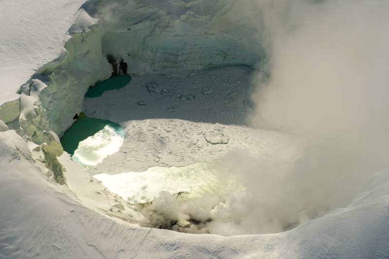
View of the Mount Spurr summit crater lake on an April 25 overflight and gas survey. The water is greenish blue to yellow, due to suspected sulfur precipitates in the water. Floating ice covers the southern half of the lake. The fumarole field on the north shoreline is visibly steaming (bottom of image).
Although unrest continues, there have been no changes observed in the monitoring data to indicate that the volcano is moving closer to an eruption. Based on previous eruptions, changes from current activity in the earthquakes, ground deformation, summit lake conditions, and fumarolic activity would be expected if magma began to move closer to the surface. Therefore, if an eruption occurred, it would be preceded by additional signals allowing warning.
The volcano is monitored using local seismic, infrasound, web camera, and GNSS (GPS) stations along with regional infrasound, lightning networks and satellite data.
Source : AVO
Photo : Loewen, Matt/ AVO/USGS .
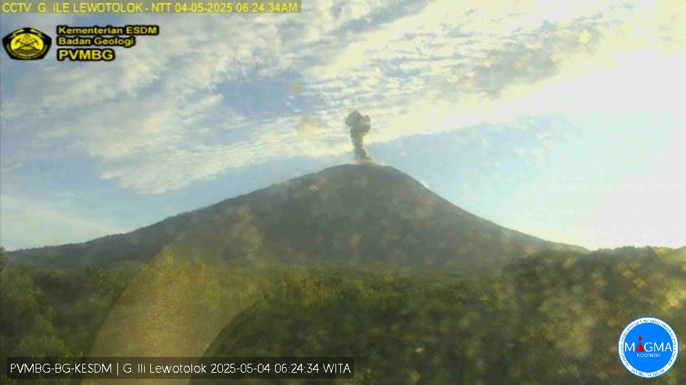
Indonesia , Ili Lewotolok :
An eruption of Mount Ili Lewotolok occurred on Sunday, 4 May 2025 at 01:30 UTC (09:30 local time) with an observed ash column height of ± 600 m above the peak (± 1,920 ft above sea level). The ash column was observed to be gray with moderate intensity, oriented west. This eruption was recorded on a seismograph with a maximum amplitude of 38.9 mm and a duration of 25 seconds.
VOLCANO OBSERVATORY NOTICE FOR AVIATION – VONA
Issued : May 04 , 2025
Volcano : Ili Lewotolok (264230)
Current Aviation Colour Code : ORANGE
Previous Aviation Colour Code : orange
Source : Ili Lewotolok Volcano Observatory
Notice Number : 2025LEW012
Volcano Location : S 08 deg 16 min 19 sec E 123 deg 30 min 18 sec
Area : East Nusa Tenggara, Indonesia
Summit Elevation : 4554 FT (1423 M)
Volcanic Activity Summary :
Eruption with volcanic ash cloud at 01h30 UTC (09h30 local).
Volcanic Cloud Height :
Best estimate of ash-cloud top is around 6474 FT (2023 M) above sea level or 1920 FT (600 M) above summit. May be higher than what can be observed clearly. Source of height data: ground observer.
Other Volcanic Cloud Information :
Ash cloud moving to west. Volcanic ash is observed to be gray. The intensity of volcanic ash is observed from medium to thick.
Remarks :
Eruption recorded on seismogram with maximum amplitude 38.9 mm and maximum duration 25 second
Source et photo : Magma Indonésie .
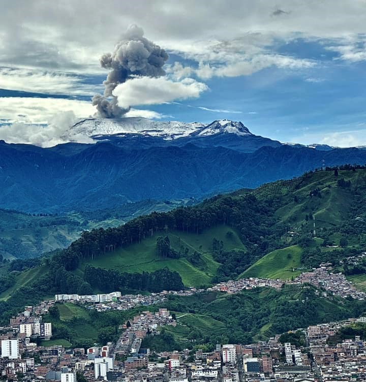
Colombia , Nevado del Ruiz :
Manizales, April 29, 2025, 5:30 p.m.
Monitoring the activity of the Nevado del Ruiz volcano, the Colombian Geological Survey (SGC), an entity affiliated with the Ministry of Mines and Energy, reports that:
During the week of April 22-28, 2025, the volcano continued to exhibit unstable behavior. Compared to the previous week, the main variations in the monitored parameters were:
– Seismic activity associated with rock fracturing processes within the volcanic edifice maintained similar levels in the number of recorded earthquakes and the seismic energy released. The earthquakes were located in the Arenas crater and, mainly, at distances less than 5 km from it, on the northeast, southeast, east, and south flanks of the volcano. The depth of the earthquakes ranged from less than 1 km to 8 km from the volcanic summit.
The recorded events had low energy levels (magnitudes less than 1).
– Seismic activity related to the lava dome (prominence or mound) located at the crater floor increased significantly in the number of events, despite exhibiting low energy levels. This seismic activity occurred particularly on April 27, the day with the highest number of events recorded so far this year.
– Seismic signals related to fluid dynamics in volcanic conduits increased in the number of recorded earthquakes and in the seismic energy released.
The energy levels of the seismic signals ranged from low to moderate. Some of these events were associated with pulsatile ash emissions or changes in the apparent temperature of the emitted material. Both phenomena were confirmed using cameras (conventional or thermographic) used to monitor the volcano.
The emission of water vapor and gases into the atmosphere, primarily sulfur dioxide (SO₂), through the Arenas crater varied throughout the week. Estimated SO₂ outgassing flux values decreased compared to previous weeks, largely because atmospheric conditions at the beginning of the week were not conducive to data collection. Satellite monitoring, which is being carried out to complement the assessment of this parameter, revealed significant SO₂ releases.
– The vertical height of the gas and water vapor column remained mainly below 1000 m, with a maximum of 1800 m (measured above the volcanic summit). During dispersal, the highest height reached was 2000 m during the ash emission recorded on April 26 at 10:51 p.m. The dispersion direction showed a preferential trend toward the northern flank, varying between northeast and north-northwest, with a predominance toward the northeast of the volcano.
– In monitoring thermal anomalies at the floor of Arenas Crater using satellite monitoring platforms, detection was limited due to the persistence of atmospheric conditions of high cloudiness in the area. However, some reports of low energy levels were obtained.
Source : SGC
Photo : Alex Jimenez Matiz ( 2023)
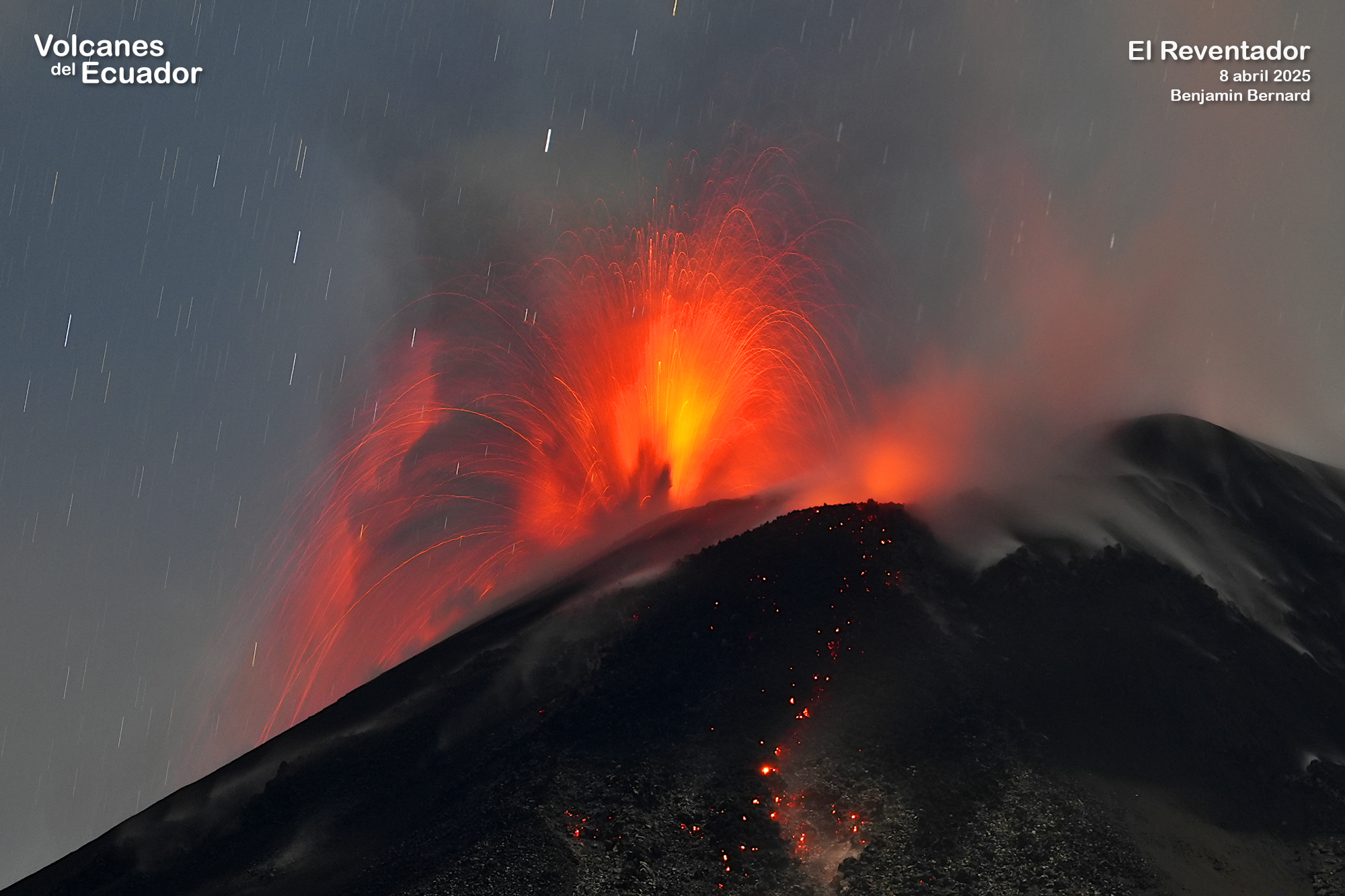
Ecuador , El Reventador :
DAILY STATUS REPORT OF REVENTADOR VOLCANO, Saturday, May 3, 2025.
Information Geophysical Institute – EPN.
Surface Activity Level: High, Surface Trend: No change
Internal Activity Level: Moderate, Internal Trend: No change
From May 2, 2025, 11:00 a.m. to May 3, 2025, 11:00 a.m.:
Seismicity:
Below is the count of seismic events recorded at the reference station.
Explosion (EXP) 82
Long Period (LP) 22
Emission Tremor (TREMI) 14
Harmonic Tremor (TRARM) 3
Rainfall/Lahars:
No rainfall has been recorded in the volcano area. No mud or debris flows have been reported. **Heavy rainfall could remobilize accumulated material, generating mud and debris flows that would cascade down the volcano’s flanks and flow into adjacent rivers.
Emission/Ash Column:
Yesterday afternoon, the surveillance camera system recorded several gas and ash emissions reaching heights of 500 to 1,000 meters above the crater in a northwest and west direction. Associated with this activity, the Washington VAAC agency issued a report of an ash cloud in a northwest direction with a height of 705 to 1,315 meters above the crater level.
Other monitoring parameters:
The MIROVA-MODIS satellite system recorded a weak thermal anomaly over the past 24 hours.
Observation:
Yesterday evening, the surveillance camera system observed the descent of incandescent material on the south and southeastern flanks, up to 1,100 meters below the crater level. As of the closing date of this report, the volcano remained cloudy most of the time.
Alert Level – SGR: Orange
Source : IGEPN
Photo : Benjamin Bernard via volcanes ecuador / FB. ( 08/04/2025)
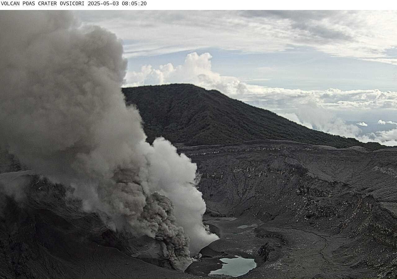
Costa Rica , Poas :
Poás Volcano Activity Report. Updated May 2, 2025
Summary:
OVSICORI-UNA observes continuity in eruptive activity, with variability in monitoring parameters. This week, the following were observed:
● An eruptive event more than 4 km above the crater level (April 27)
● The eruptions are phreatomagmatic in nature.
● Stable seismic parameters
● Ash emission is almost continuous, with dispersion mainly toward the western quadrant and sporadically toward the south-southwest.
● Slight deformation. ● High level of degassing
● Low to moderate juvenile material content
A high probability of eruptions remains in effect, which could impact areas of Poás Volcano National Park visited by tourists (bomb or rock fall, ash, gas, aerosols), as well as communities surrounding Poás Volcano (ash, gas, aerosols) in the coming days and weeks.
The volcano’s activity level is at WARNING level 3 out of 4.
Eruptive Activity
The eruptive phase that began on March 23rd is continuing at the time of writing. Although eruptive activity is nearly continuous, the energy and explosiveness of the eruptions vary, ranging from continuous ash emissions to explosions of varying amplitude. The most significant eruptive event of the past week occurred on Sunday, April 27th at 1:02 PM. This event was very similar to those of the 21st and 23rd: ejection from Vent A, primarily, with an eruptive column greater than 4 km above the crater level and a duration of more than 5 minutes. Another significant event occurred the previous evening, when ballistic projections of blocks to heights of up to approximately 500 m were observed for several minutes. Another minor pulse occurred in the early hours of the 30th at 4:20 AM.
Seismic and Acoustic Activity
This week, background tremor maintained a stable baseline with little variability. The only increases in seismic amplitude were related to eruptive events and isolated tremor episodes such as the one that occurred on the 27th, 17 hours before the major eruptive event. Approximately 10 long-period (LP) events are observed daily.
The number of volcano-tectonic events remains low, with two distal events and three proximal events.
As for acoustic activity, it remains virtually constant, reflecting the continuity of the eruption and its variability. The eruption on April 27th had an infrasound magnitude of 4.1, the same as that of April 23rd. Before the minor event on the 30th, a gradual decrease in acoustic tremor was observed until the signal disappeared completely for just over two hours before the eruption.
Source et photo : Ovsicori.