3 Mai 2025.
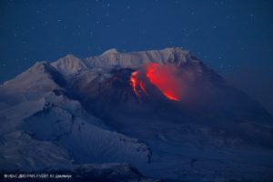
Hawaii , Kilauea :
Thursday, May 1, 2025, 10:32 PM HST (Friday, May 2, 2025, 08:32 UTC)
19°25’16 » N 155°17’13 » W,
Summit Elevation 4091 ft (1247 m)
Current Volcano Alert Level: WATCH
Current Aviation Color Code: ORANGE
Activity Summary:
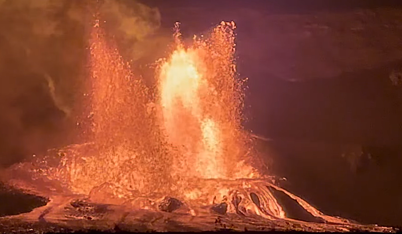
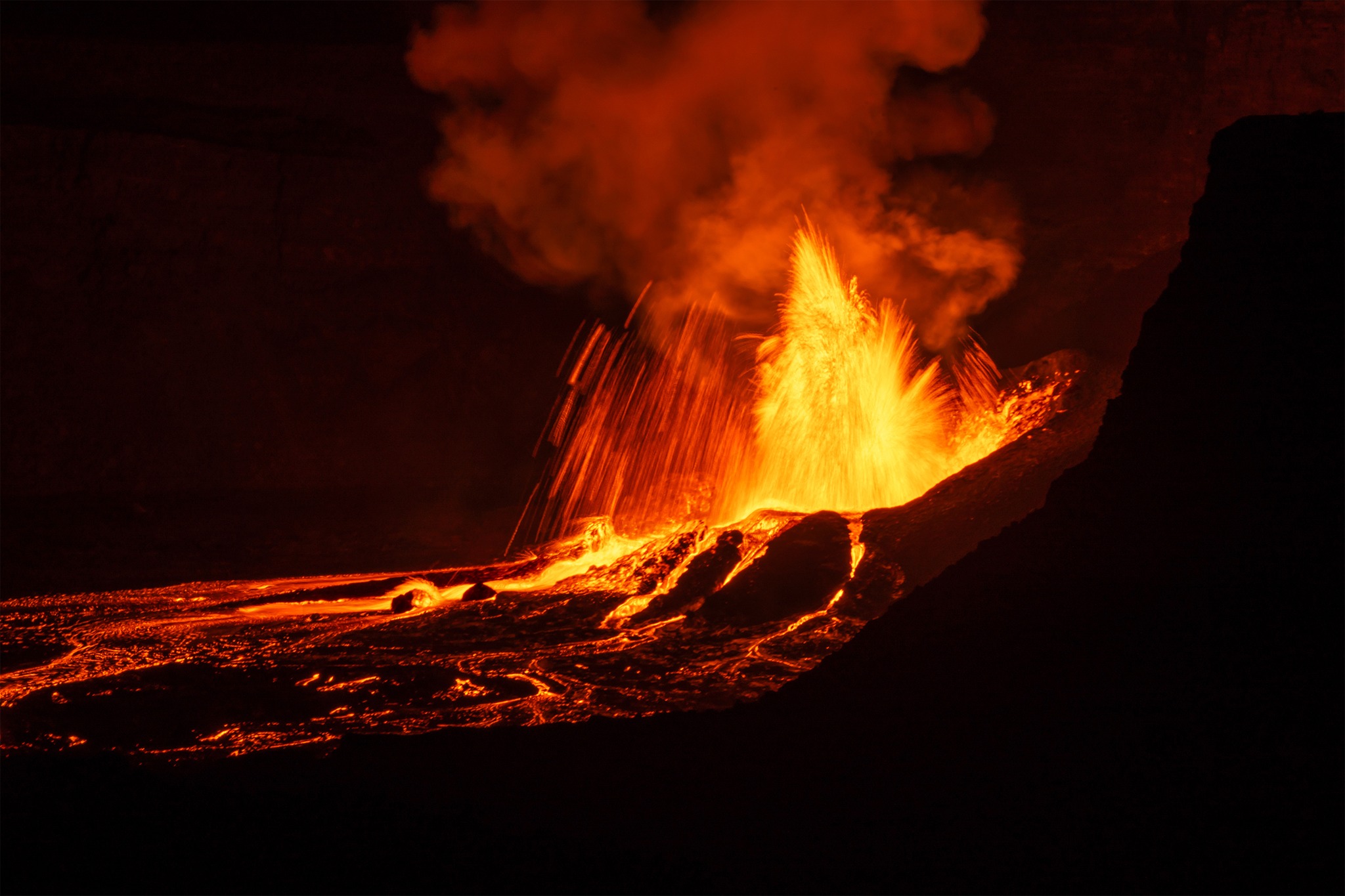
Episode 19 of the ongoing Halemaʻumaʻu eruption began at about 9:28 p.m. HST on May 1 with 200-300 foot (60-100 meter) high fountains from the north vent.
Episode 19 was preceded by 26 cycles of low dome fountaining and short overflows from the north vent followed immediately by lava draining back into the vent. Each cycle of fountaining lasted for about 10–15 minutes, separated by about 10 minutes of repose. These precursory fountaining cycles began at approximately 11:49 a.m. and increased in intensity around 6:45 p.m., less than 3 hours before sustained fountaining began. Fountains from the north vent are estimated to be about 330 feet (100 meters) high with multiple lava streams flooding the southwestern portion of the crater floor.
Inflationary tilt reached about 12 microradians since the end of the last episode. Seismic tremor began increasing and tilt at UWD switched from inflation to deflation at about 9:28 p.m. HST, about the same time fountain heights began to increase.
Each episode of Halemaʻumaʻu lava fountaining since December 23, 2024, has continued for 13 hours to 8 days and episodes have been separated by pauses in eruptive activity lasting less than 24 hours to 12 days.
No changes have been detected in the East Rift Zone or Southwest Rift Zone. HVO continues to closely monitor Kīlauea and will issue an eruption update tomorrow morning unless there are significant changes before then.
Friday, May 2, 2025, 6:18 AM HST (Friday, May 2, 2025, 16:18 UTC)
Activity Summary:
The main fountaining of episode 19 of the ongoing Halemaʻumaʻu eruption, which began at about 9:28 p.m. HST on May 1, ended at 5:20 a.m. HST on May 2 after erupting from the north vent for just under 8 hours.
Episode 19 was preceded by over 9 hours of cycles of low dome fountaining and short overflows from the north vent followed immediately by lava draining back into the vent, which started at 11:49 a.m. HST on May 1. Sustained fountaining from the north vent only, began at 9:28 p.m. HST on May 1 and lasted for 7 hours and 52 minutes with maximum estimated heights at about 330 feet (100 meters). The eruption produced just under 4 million cubic yards (3 million cubic meters) of lava and the flows covered about half of the Halema’uma’u crater floor.
.
About 7 microradians of deflationary tilt were recorded at UWD during the main fountaining of episode 19, and the tiltmeter began recording inflation as soon as the lava was draining in the vent at 5:20 a.m. HST this morning. Seismic tremor began decreasing as the tilt switched and lava fountaining stopped, with weak tremor still being recorded as typical during eruptive pauses.
Friday, May 2, 2025, 3:30 PM HST (Saturday, May 3, 2025, 01:30 UTC)
On Friday, May 2, 12:59 p.m. HST, a magnitude-3.6 earthquake occurred 4 mi (6 km) west-southwest of Laupāhoehoe on the Island of Hawaiʻi at a depth of 19 mi (31 km) below sea level. The earthquake had no apparent impact on either Mauna Loa or Kīlauea volcanoes.
The depth, location, and recorded seismic waves of the earthquake suggest a source due to bending of the oceanic plate from the weight of the Hawaiian island chain, a common source for earthquakes in this area. The event is likely related to stress from the weight of the island on the underlying ocean crust and was not directly related to volcanic processes.
The USGS Hawaiian Volcano Observatory continues to monitor Hawaiian volcanoes for any changes.
Source : HVO
Photos : Andrew Gaspar / Capture d’écran 2/05/2025 , Janice Wei / FB.
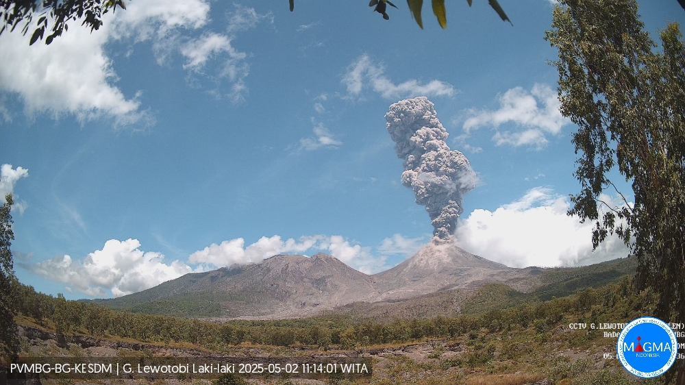
Indonesia , Lewotobi Laki-laki :
An eruption of Mount Lewotobi Laki-laki occurred on Friday, May 2, 2025, at 11:07 WITA with an observed ash column height of ± 3,500 m above the peak (± 5,084 m above sea level). The ash column was observed to be gray to brown in color, with a thick intensity, oriented toward the north and northeast. This eruption was recorded on a seismograph with a maximum amplitude of 47.3 mm and a duration of 79 seconds.
VOLCANO OBSERVATORY NOTICE FOR AVIATION – VONA
Issued : May 02 , 2025
Volcano : Lewotobi Laki-laki (264180)
Current Aviation Colour Code : ORANGE
Previous Aviation Colour Code : orange
Source : Lewotobi Laki-laki Volcano Observatory
Notice Number : 2025LWK307
Volcano Location : S 08 deg 32 min 20 sec E 122 deg 46 min 06 sec
Area : East Nusa Tenggara, Indonesia
Summit Elevation : 5069 FT (1584 M)
Volcanic Activity Summary :
Eruption with volcanic ash cloud at 03h07 UTC (11h07 local).
Volcanic Cloud Height :
Best estimate of ash-cloud top is around 16269 FT (5084 M) above sea level or 11200 FT (3500 M) above summit. May be higher than what can be observed clearly. Source of height data: ground observer.
Other Volcanic Cloud Information :
Ash cloud moving from north to northeast. Volcanic ash is observed to be gray to brown. The intensity of volcanic ash is observed to be thick.
Remarks :
Eruption recorded on seismogram with maximum amplitude 47.3 mm and maximum duration 79 second.
Source et photo : Magma Indonésie .
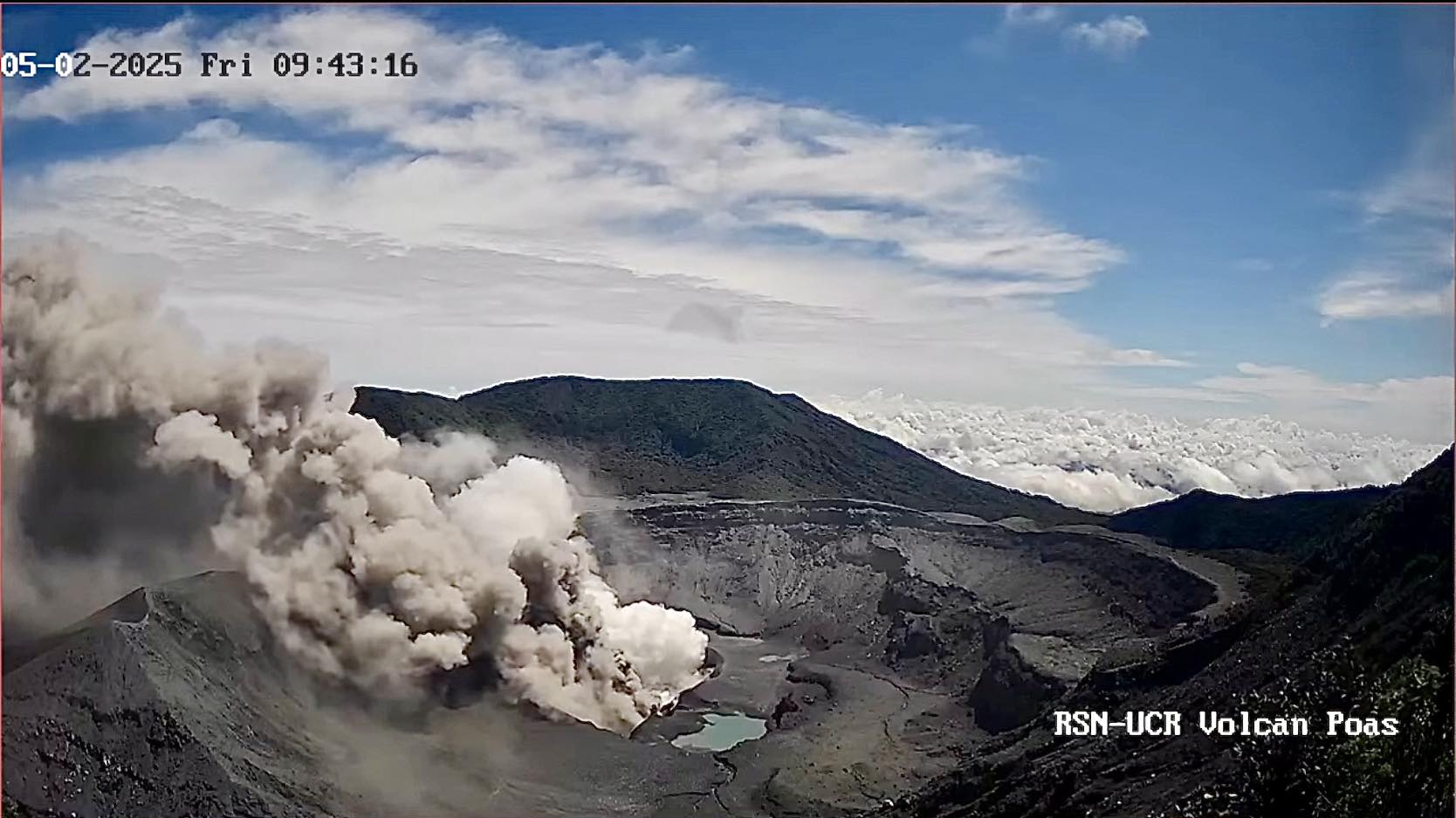
Costa Rica , Poas :
Poás Volcano Activity Statement, Updated May 2, 2025
Summary:
OVSICORI-UNA observes continuity in eruptive activity, with variability in monitoring parameters. This week, the following were observed:
● An eruptive event more than 4 km above the crater level (April 27)
● The eruptions are phreatomagmatic in nature.
● Stable seismic parameters
● Ash emission is almost continuous, with dispersion mainly toward the western quadrant and sporadically toward the south-southwest.
● Slight deformation.
● High level of degassing
● Low to moderate content of juvenile material
OVSICORI-UNA raised the Volcanic Alert Level to Level 3 (WARNING) on March 7, 2025, following an increase in monitored geophysical and geochemical parameters (seismic activity, crustal deformation, gas and ash composition).
Since Sunday, March 23, a new phase of this eruptive cycle characterized by almost continuous phreatomagmatic eruptions of moderate energy has been observed.
A high probability of eruptions remains in effect, which could impact areas of Poás Volcano National Park visited by tourists (bomb or rock fall, ash, gas, aerosols), as well as the populations surrounding the Poás Volcano (ash, gas, aerosols) in the coming days and weeks.
The volcano’s activity level is at WARNING level 3 out of 4.
Eruptive Activity
The eruptive phase, which began on March 23, is continuing at the time of writing.
Although eruptive activity is nearly continuous, the energy and explosiveness of the eruptions vary, ranging from continuous ash emissions to explosions of varying amplitude. The most significant eruptive event of the past week occurred on Sunday, April 27, at 1:02 p.m. This event was very similar to those of April 21 and 23: ejection primarily from Vent A, with an eruptive column greater than 4 km above the crater level and a duration of more than 5 minutes. Another significant event occurred the previous evening, when ballistic projections of blocks to heights of up to approximately 500 m were observed for several minutes. Another minor pulse occurred in the early hours of the 30th at 04:20.
Source : Ovsicori
Photo : RSN-UCR.
La Martinique , Mount Pelée :
Weekly Report, Paris Institute of Earth Physics, Martinique Volcanological and Seismological Observatory
Saint-Pierre, May 2, 2025 at 4:00 PM (GMT-4)
Volcanic activity remained high this week, with 137 earthquakes of volcanic origin observed.
Between April 25, 2025 at 4:00 PM (UTC) and May 2, 2025 at 4:00 PM (UTC), the OVSM recorded:
• 107 low-energy volcano-tectonic earthquakes. These earthquakes were clearly identified as originating from one of the well-known seismically active zones on Mount Pelée,
located between 1.0 and 1.4 km deep below the volcano’s summit. The shallow volcano-tectonic seismicity is associated with microfracturing within the volcanic edifice, linked to the overall reactivation of the volcano observed since late 2018.
• 22 long-period earthquakes. 18 of these earthquakes were located, ranging in depth from 17 to 40 km. Their magnitude ranges from Mlv = 0.4 to Mlv = 1.2. Deep long-period earthquakes contain only low frequencies and are associated with the circulation of magmatic fluids deep within the volcanic system of Mount Pelée.
• 8 deep hybrid earthquakes located at depths between 22 and 37 km and with magnitudes between Mlv = 0.6 and Mlv = 2.15. Hybrid seismic signals are enriched at low frequencies and are also generally associated with the circulation of magmatic fluids deep within the volcanic system of Mount Pelée.
The preliminary hypocenters of the localized long-period and deep hybrid earthquakes are concentrated mainly in two areas: the first located southwest of Mount Pelée between 17 and 23 km deep, and the second located southeast of Mount Pelée between 30 and 40 km deep.
No earthquakes were felt by the population.
The previous week, the OVSM recorded 201 earthquakes of volcanic origin. As of May 2, 2025, and over the past four weeks, the OVSM has observed a total of 388 volcanic earthquakes, an average of 97 earthquakes per week.
During phases of volcanic reactivation in volcanoes similar to Mount Pelée, seismic activity of varying intensity and frequency is commonly observed.
The alert level is currently YELLOW: vigilance.
Source : Direction de l’OVSM-IPGP
Photo : OVSM
Guatemala , Santiaguito :
Atmospheric Conditions: Cloudy.
Wind: Southeast.
Precipitation: 10.0 mm.
Activity:
The Santa María-Santiaguito Volcanic Complex Observatory reports unfavorable atmospheric conditions for observing Dome Caliente. Degassing is occurring, raising columns of magmatic gas. Between one and two weak to moderate explosions per hour are reported, also generating columns of gas accompanied by ash, which can reach heights of 800 meters above the crater level. These columns are being displaced westward and northwestward by the wind direction, so light ashfall is expected on Monte Bello, Loma Linda, Monte Maria, and the surrounding areas.
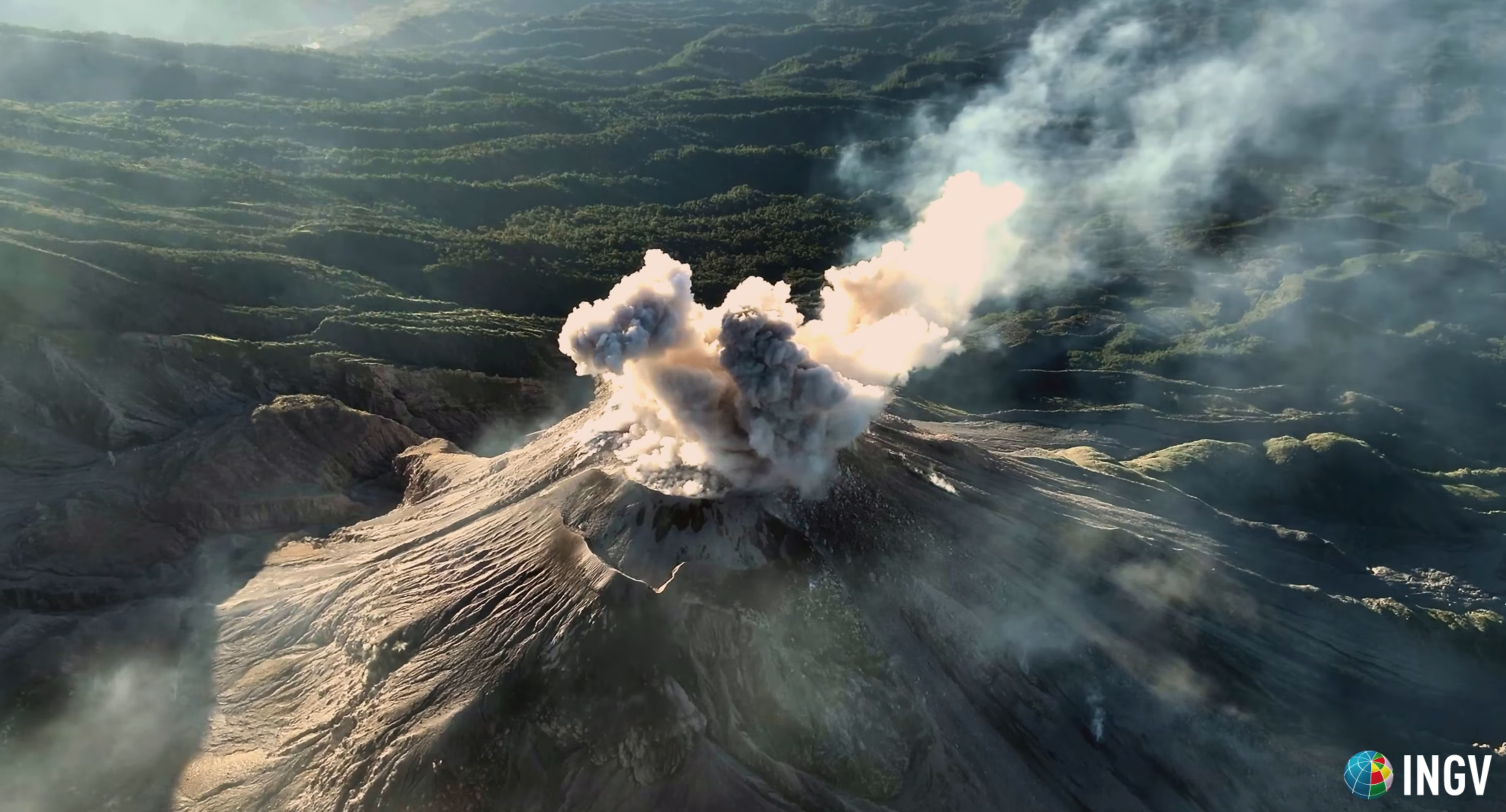
Activity remains high, so it is possible that due to explosions or the effects of gravity, some of the accumulated material could collapse and generate large-scale pyroclastic flows towards the southwest, south, and southeast. For these reasons, follow the recommendations described in special bulletin BESAN-002-2025.
Source : Insivumeh
Photo : capture d’écran INGV Dr. Riccardo Civico