May 2 , 2025.
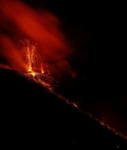
Hawaii , Kilauea :
The 10th cycle of the episode 19 precursory pistoning activity at the north vent began at 3:07 pm HST. Lava from the low dome fountains filled the cone and produced short overflows of the rim. The lava started to drain back at 3:20 pm HST.
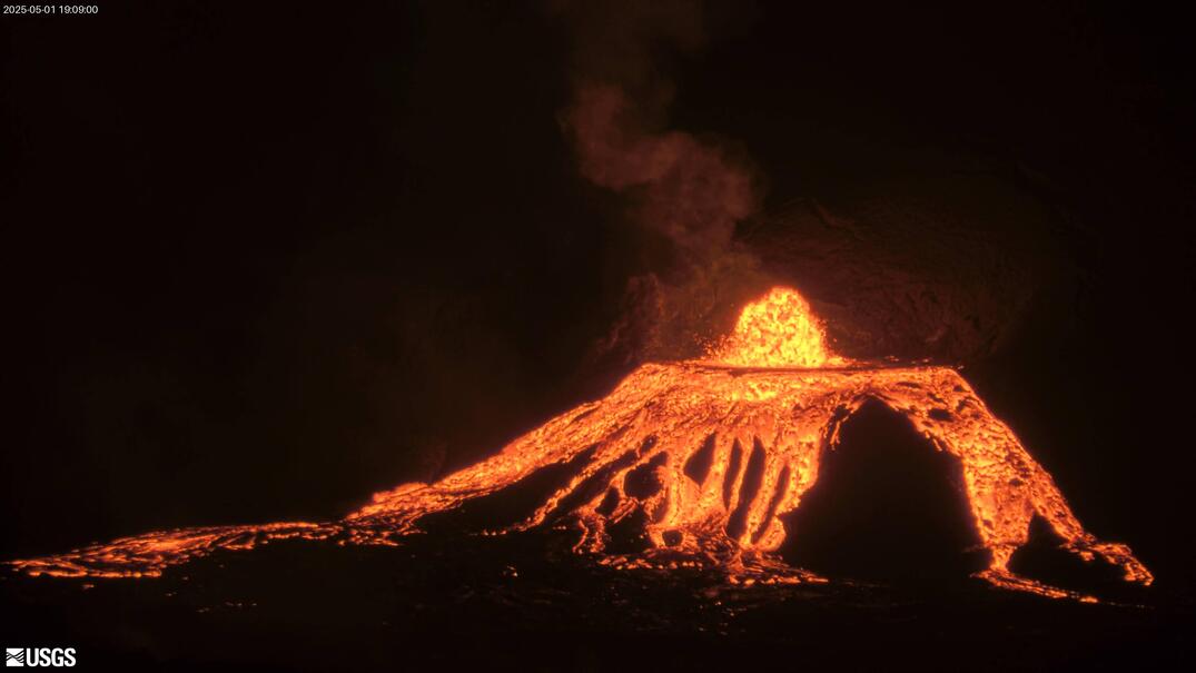
The pause in the ongoing Kilauea summit eruption continues, although the next episode of activity could begin at any moment.
On Wednesday night, nearly continuous lava spattering and flames were observed at the north vent within Halemaʻumaʻu crater.
“Spatter bursts continue to increase with heights just over 30 feet (10 meters) at 8:30 pm HST,” the USGS Hawaiian Volcano Observatory wrote in a short update. “The flames are likely due to burning of hydrogen gas.”
By morning, the activity at the vent had once again settled down, although occasional spattering could still be seen.
Source : HVO , Big island video news .
Photo : Webcam
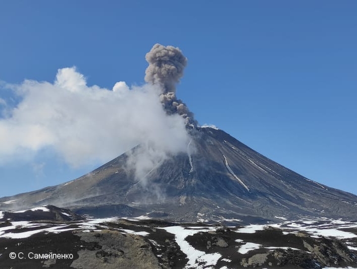
Kamchatka , Karymsky :
VOLCANO OBSERVATORY NOTICE FOR AVIATION (VONA)
Issued: April 30 , 2025
Volcano: Karymsky (CAVW #300130)
Current aviation colour code: ORANGE
Previous aviation colour code: yellow
Source: KVERT
Notice Number: 2025-27
Volcano Location: N 54 deg 2 min E 159 deg 26 min
Area: Kamchatka, Russia
Summit Elevation: 1486 m (4874.08 ft)
Volcanic Activity Summary:
A moderate explosive activity of the volcano resumed on 29 April, 2025, after a pause that lasted since 12 November, 2024. Satellite data by KVERT show two ash clouds continue to move for about 120 km to the east and northeast of the volcano from an explosion at 13:20 UTC on 30 April, 2025; and from an explosion at 18:30 UTC on 30 April, 2025. KVERT continues to monitor the Karymsky volcano.
A moderate activity of the volcano continues. Ash explosions up to 10 km (32,800 ft) a.s.l. could occur at any time. Ongoing activity could affect international and low-flying aircraft.
Volcanic cloud height :
3500-4000 m (11480-13120 ft) AMSL Time and method of ash plume/cloud height determination: 20250430/1830Z – Himawari-9 14m15
Other volcanic cloud information:
Distance of ash plume/cloud of the volcano: 10 km (6 mi)
Direction of drift of ash plume/cloud of the volcano: ENE / azimuth 76 deg
Time and method of ash plume/cloud determination: 20250430/1830Z – Himawari-9 14m15
Source : Kvert
Photo : S. Samoylenko ( 2022 )
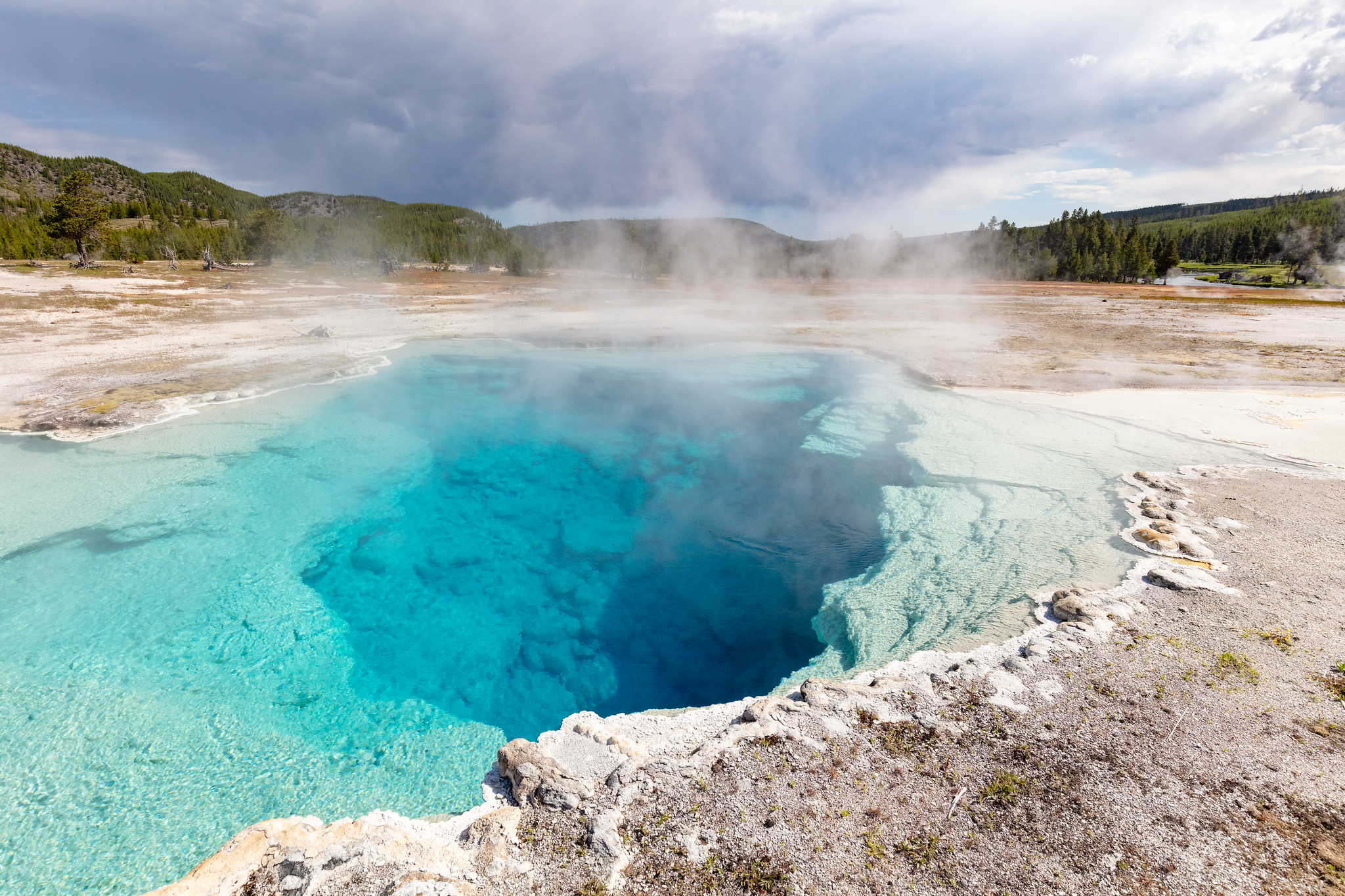
United – States , Yellowstone :
Thursday, May 1, 2025, 10:50 AM MDT (Thursday, May 1, 2025, 16:50 UTC)
44°25’48 » N 110°40’12 » W,
Summit Elevation 9203 ft (2805 m)
Current Volcano Alert Level: NORMAL
Current Aviation Color Code: GREEN
Summary
Yellowstone Caldera activity remains at background levels, with 46 located earthquakes in April (largest = M1.8). Deformation measurements indicate a small amount of caldera subsidence since early October.
Recent Work and News
Steamboat Geyser erupted for the second time of 2025 on April 14. Since then, the geyser has been quiet, but minor activity will probably resume in early May if the geyser starts to build to a new major eruption in the weeks to come.
May means the start of the field season in Yellowstone National Park! Geologists are currently in the park collecting geophysical and geochemical data from the Mud Volcano area and will also be deploying semi-permanent GPS stations in the region to track surface deformation. These stations are set up every spring to densify the continuous GPS network, and they are recovered in the fall before they are buried by snow. Additional work later in May will include maintenance of monitoring stations and scouting locations for a new monitoring station in the Biscuit Basin area, where a hydrothermal explosion occurred on July 23, 2024.
Seismicity
During April 2025, the University of Utah Seismograph Stations, responsible for the operation and analysis of the Yellowstone Seismic Network, located 46 earthquakes in the Yellowstone National Park region. The largest event of the month was a micro earthquake of magnitude 1.8 located about 13 miles north-northeast of Pahaska Tepee, Wyoming, on April 27 at 11:10 AM MDT.
There were no swarms identified during the month of April.
Yellowstone earthquake activity remains at background levels.
Ground Deformation
Continuous GPS stations in Yellowstone Caldera recorded a small amount (about 3 centimeters, or 1.2 inches) of subsidence since October. This pattern and rate of subsidence continues a trend that started in 2015–2016. Minor subsidence (about 1 centimeter, or about half an inch) was also measured by a continuous GPS station near Norris Geyser Basin since the end of last summer.
Source : YVO
Photo : Sapphire pool / National Park Service / Jacob W. Frank, July 20, 2020.
Indonesia , Ibu :
Mount Ibu, West Halmahera, will be downgraded from Level III (SIAGA) to Level II (WASPADA) on May 1, 2025, at 5:00 PM WIT.
On May 1, 2025, at 5:00 PM WIT, the activity level of Mount Ibu in Ibu District, West Halmahera Regency, North Maluku Province, was officially downgraded from Level III (Siaga) to Level II (Waspada). Mount Ibu (1,340 m above sea level) is being closely monitored from the Volcano Observation Post (PGA) in Gam Ici Village.
This decrease in activity level is based on the results of visual observations and data from monitoring equipment since February 2025. Seismic activity has decreased, eruptions are still occurring but with a lower eruption column height, and the ejection of incandescent lava now reaches a distance of only about 200 meters from the crater rim. Surface measurement data from the mountain show some signs of reduced pressure inside the volcano.
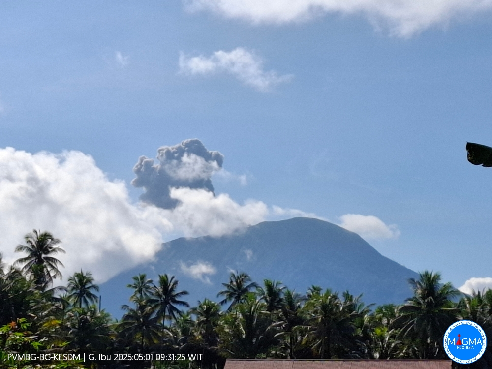
An eruption of Mount Ibu occurred on Thursday, May 1, 2025, at 9:30 a.m. WIT, with an observed ash column height of ± 400 m above the peak (± 1,725 m above sea level). The ash column was observed to be gray in color with a thick intensity, oriented northeast. This eruption was recorded on a seismograph with a maximum amplitude of 28 mm and a duration of 38 seconds.
Communities around Mount Ibu should remain vigilant regarding volcanic activity on Mount Ibu. Potential hazards that may still occur include volcanic ash rain during explosive eruptions, ejections of incandescent lava, hot clouds, and lahar flows in rivers that originate at the summit of Mount Ibu.
The public is advised not to carry out any activities within the danger zone and to always follow the instructions of the authorities. Official information regarding activities at Mount Ibu will continue to be provided by the relevant agencies to ensure everyone’s safety.
Source et photo : PVMBG , Magma Indonésie.
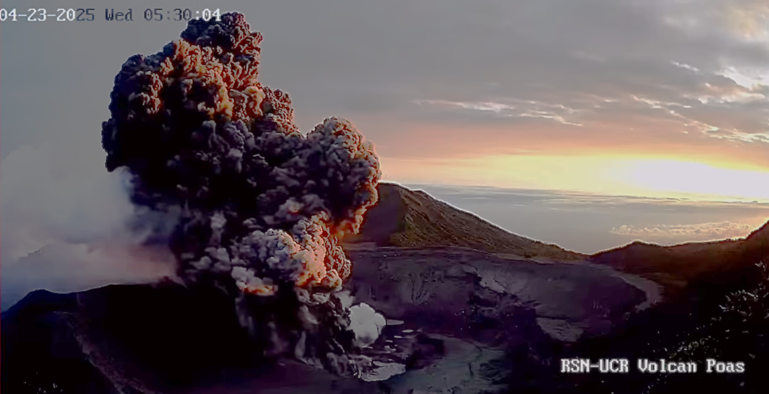
Costa Rica , Poas :
Daily Volcano Status Report. May 1, 2025
Updated at: 8:27:00 PM.
Latitude: 10.2
Longitude: -84.233
Height: 2,687 meters
Observed Activity:
The volcano continues to erupt, constantly emitting abundant ash and gases. Seismographs and infrasound sensors continuously record seismic-acoustic signals of a continuous eruption, with frequent pulses of more intense signals, such as the one recorded this morning, May 1st, at 3:15 a.m., associated with an eruptive pulse with a plume approximately 500 meters high. The GPS network measuring crustal deformation continues to detect horizontal and vertical expansion movements, suggesting the presence of a magmatic body pushing the crust. Early today, May 1st, 2025, around 3:00 a.m., a group of scientists from Canada and OVSICORI-UNA remotely measured the heat flow and temperature using a drone, obtaining a temperature of 180 degrees Celsius. This temperature indicates that there is no lava near the surface.
Environmental Conditions:
The summit wind is west-southwest. The volcano is cloudy.
Activity Level: Caution (3)
Source : Ovsicori
Photo : RSN UCR Capture d’écran 24 Avril 2025