May 1 , 2025.
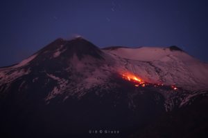
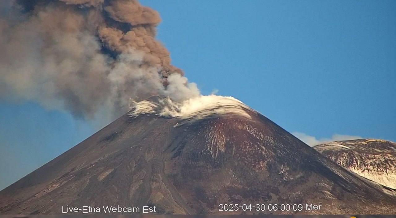
Italy / Sicily , Etna :
Etna Activity Report, April 30, 2025. 2:36 PM (12:36 UTC).
The National Institute of Geophysics and Volcanology, Osservatorio Etneo, reports that surveillance cameras show that the eruptive activity at the Southeast Crater, reported in previous reports, gradually subsided during the morning.
The explosive activity has ended, and the lava flows are no longer being fed and are cooling. From a seismic perspective, the average amplitude of the volcanic tremor ended its upward trend at 00:00 UTC, when it reached the maximum value for the episode. Subsequently, starting around 03:00 UTC, a sudden decrease in amplitude was observed, reaching medium-low values, where it persists to this day.
The centroid of the tremor sources is currently located in an area between the Southeast Crater and the Northeast Crater at an altitude of approximately 2,000 m above sea level. Infrasound activity has decreased to pre-volcanic levels, and infrasound events are currently located in the Northeast Crater area with medium to low amplitudes.
Over the past few hours, observation systems monitoring ground deformation have not shown any significant variations.
Further updates will be provided shortly.
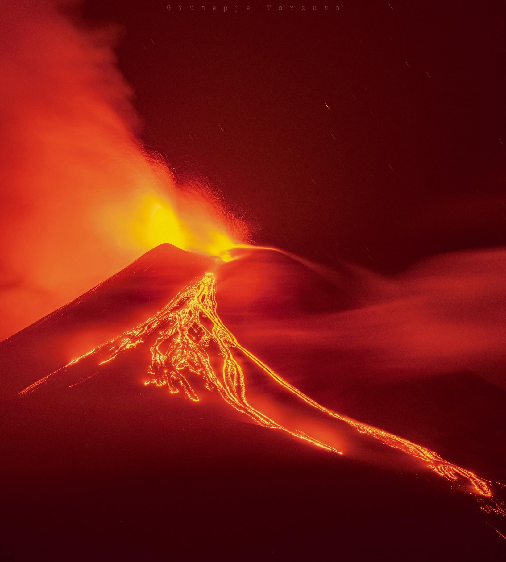
The Sezione di Catania – Osservatorio Etneo (INGV) reported continuing activity at Etna during 21-27 April, characterized by Strombolian activity with lava overflows at SE Crater and gas emissions at Bocca Nuova Crater, NE Crater, and Voragine. Strombolian activity at SE Crater began at 2000 on 22 April that involved at least three vents and was followed by lava overflowing onto the SE flank. At 2145 a second lava flow descended the S flank. The activity ceased at around 0300 on 23 April. Satellite data from 27 April was used to map the flows. The SE-flank flow covered an area of about 34,000 square meters and was about 700 m long, reaching 2,940 m elevation. The S-flank flow covered about 6,000 square meters and was about 200 m long, reaching 3,170 m elevation.
Source : INGV , GVP.
Photos : webcam , Giuseppe Tonzuzo , via Boris Behncke / FB.
Tonga Archipelago , Home Reef :
The Tonga Geological Services reported continuing activity at Home Reef. Satellite imagery from 4 April captured a series of small low-level ash plumes generated by explosions. Surface changes at the vent, including new tephra deposits and lava textures, were identified in a 5 April satellite image. A satellite image from 11 April indicated that the vent had the same dimensions as previously reported, 125 m N-S and 110 m W-E. The dome in the vent had grown, mainly to the SW, and spalled or ejected material that rolled down to the shoreline. In both 11 and 26 April images steam plumes rose from the vent and water around the island was discolored. Moderate thermal anomalies were detected by the Middle InfraRed Observation of Volcanic Activity (MIROVA) system during 8-28 April.
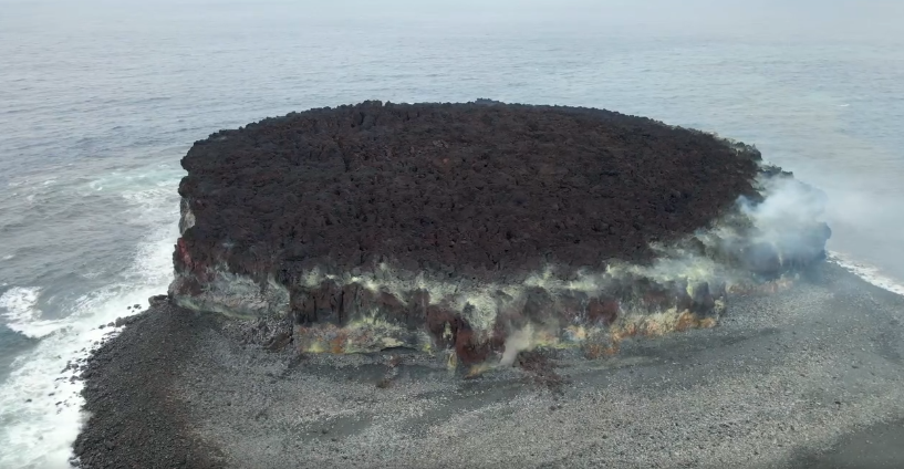
A sulfur dioxide emission was identified in a 22 April satellite image. Ash emissions were visible in satellite data at around 1400 on 26 April, prompting Tonga Geological Services to raise the Aviation Color Code to Orange (the second highest level on a four-level scale) that same day. According to the Wellington VAAC intermittent, low-level ash plumes were visible in satellite images during 26-27 and 29 April rising 0.9-1.2 km (3,000-4,000 ft) a.s.l. and drifting W and NW. The Maritime Alert Level remained at Orange (the third level on a four-level scale), and mariners were advised to stay at least 2 nautical miles (3.7 km) away from the island. The Alert Level for residents of Vava’u and Ha’apai remained at Green (the first level on a four-level scale).
Sources: Tonga Geological Services, Government of Tonga, Wellington Volcanic Ash Advisory Center (VAAC), GVP.
Photo : Lacelid Productions ( capture d’écran , 2024)
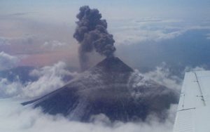
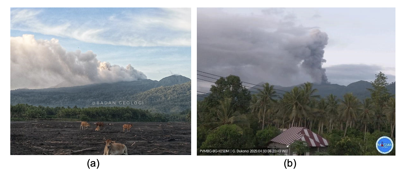
Indonesia , Dukono :
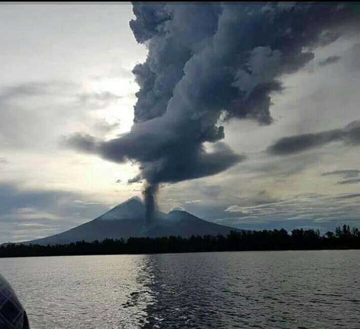
Eruption of Mount Dukono, North Maluku, on April 30, 2025.
Mount Dukono is an active volcano located on Halmahera Island. Currently, Dukono’s volcanic activity is centered in the Malupang Warirang crater at an altitude of 1,086 meters above sea level. The current intense eruptions are explosive magmatic eruptions.
In 2025, the level of volcanic activity at Mount Dukono was quite high. This was measured by the relatively high number of eruption events, ranging from 60 to 394, or an average of 227 events per day, with the height of the eruption column ranging from 200 to 2,500 meters above the peak. From March 27 to April 30, 2025 until 18:32 WIT, an eruption occurred with an eruption column height ranging from 1,000 to 1,400 m above the summit. The eruption column was observed to be gray in color with a thick intensity oriented towards the East, West and Northwest, namely mainly towards the town of Tobelo, so that volcanic ash will fall heavily towards residential areas and the town.
Based on the assessment of the Volcanology and Geological Disaster Mitigation Center (PVMBG), the Geological Agency, and the Ministry of Energy and Mineral Resources, Mount Dukono is currently still at Activity Level II (WASPADA), with a safety distance recommendation outside a 4 (four) km radius around the activity center.
The potential hazards posed by Mount Dukono around the crater at this time include rock throwing around the summit and ash rain in villages located in the western and eastern sectors, depending on the wind direction and speed around the summit of Mount Dukono. In addition, secondary hazards in the form of lahars can occur during the rainy season along the Mamuya River (northern sector). The Mede and Tauni Rivers (northeast sector), which originate at the summit of Mount Dukono, should also be alerted to the risk of lahars.
Source et photo : PVMBG
Hawaii , Kilauea :
Wednesday, April 30, 2025, 8:51 AM HST (Wednesday, April 30, 2025, 18:51 UTC)
19°25’16 » N 155°17’13 » W,
Summit Elevation 4091 ft (1247 m)
Current Volcano Alert Level: WATCH
Current Aviation Color Code: ORANGE
Activity Summary:
Episode 18 of the ongoing Halemaʻumaʻu eruption ended on April 22. Episode 19 is likely to start in the next four days, with the highest probability of beginning this evening.
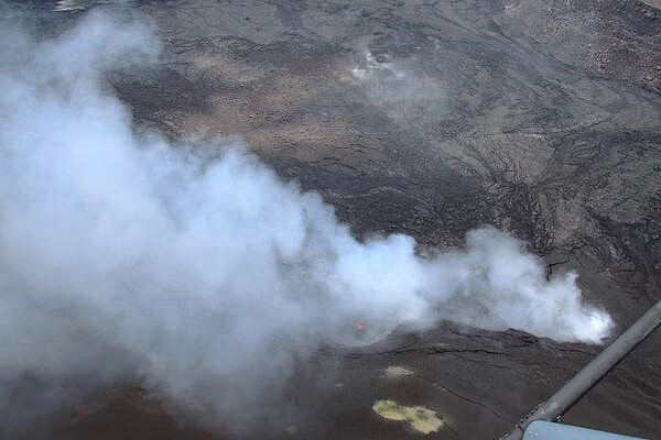
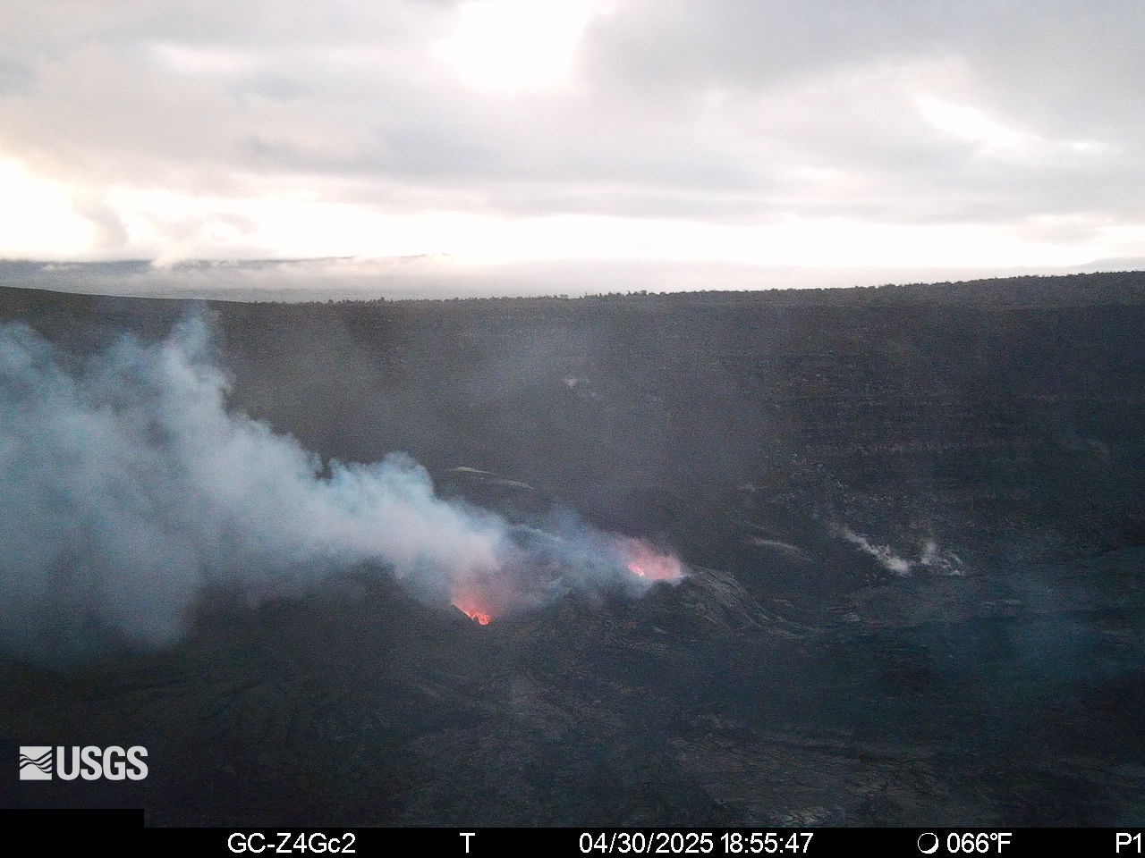
On April 29, the USGS Hawaiian Volcano Observatory undertook a helicopter surveillance flight over Halema‘uma‘u at the summit of Kīlauea volcano. At the time, the ongoing eruption was between eruptive episodes (episode 18 ended on April 22). In this photo looking down towards the east, lava is seen within north vent. The south vent is located to the right of the north vent in this photo. Lava flows from recent episodes cover most of the upper half of the photo, and tephra from recent eruptive episodes blankets the bottom part of the photo, with a patch of discoloration caused by sulfur.
Kīlauea’s current eruption in Halemaʻumaʻu crater within Kaluapele (the summit caldera) began on December 23, 2024. There have now been 18 episodes separated by pauses in activity. All eruptive activity remains within Hawaiʻi Volcanoes National Park. No significant activity has been noted along Kīlauea’s East Rift Zone or Southwest Rift Zone. Current hazards include volcanic gas emissions and windblown volcanic glass (Pele’s hair) and tephra that have impacted Hawaiʻi Volcanoes National Park and nearby communities.
Summit Observations:
Strong glow was visible last night from the north and south vents in the S2cam and V1cam webcams. Spattering and occasional flaming were seen from the north vent, along with a tiny pool of lava within the south vent. The UWD tiltmeter has recorded over 10 microradians of inflation since the end of episode 18. The last sulfur dioxide (SO2) emission rate measured on April 10 was approximately 1,200 tonnes per day. Strands of volcanic glass known as Pele’s hair from previous episodes are still present throughout the summit area of Hawaiʻi Volcanoes National Park and surrounding communities, and can be remobilized by wind.
Rift Zone Observations:
Rates of seismicity and ground deformation remain very low in the East Rift Zone and Southwest Rift Zone with no significant earthquake activity in the past 24 hours. Sulfur dioxide (SO2) emissions from the East Rift Zone remain below detection limit.
Source : HVO
Photo : USGS / N. Deligne , Webcam.
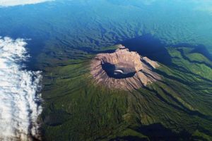
Papua New Guinea , Ulawun :
The Rabaul Volcano Observatory (RVO) reported that activity at Ulawun was low during 7-25 April. Summit emissions were white and had variable densities. On some days there were no emissions. Brief low rumbling sounds were heard during 15-16 and 19 April. In general seismicity was low, though slightly higher that background (RSAM values of 100-200). Data from the seismic station (UULA), 2.8 km from the summit on the lower WSW flank, was characterized by both low- and high-frequency volcanic earthquakes, with low-frequency earthquakes being the dominant signal. Brief surges in seismicity activity occasionally occurred and consisted of changes from discrete low- and high-frequency earthquakes to low-level, continuous volcanic tremors that lasted between several minutes and less than few hours. The Alert Level was at Stage 1 (the lowest level of a four-stage scale).
The symmetrical basaltic-to-andesitic Ulawun stratovolcano is the highest volcano of the Bismarck arc, and one of Papua New Guinea’s most frequently active. The volcano, also known as the Father, rises above the N coast of the island of New Britain across a low saddle NE of Bamus volcano, the South Son. The upper 1,000 m is unvegetated. A prominent E-W escarpment on the south may be the result of large-scale slumping. Satellitic cones occupy the NW and E flanks. A steep-walled valley cuts the NW side, and a flank lava-flow complex lies to the south of this valley. Historical eruptions date back to the beginning of the 18th century. Twentieth-century eruptions were mildly explosive until 1967, but after 1970 several larger eruptions produced lava flows and basaltic pyroclastic flows, greatly modifying the summit crater.
Sources: Rabaul Volcano Observatory (RVO), GVP.
Photo : Auther A Balisi ( 2023)