April 27 , 2025.
Alaska , Atka Volcanic Complex :
AVO/USGS Volcanic Activity Notice
Current Volcano Alert Level: ADVISORY
Previous Volcano Alert Level: NORMAL
Current Aviation Color Code: YELLOW
Previous Aviation Color Code: GREEN
Issued: Friday, April 25, 2025, 1:47 PM AKDT
Source: Alaska Volcano Observatory
Notice Number: 2025/A262
Location: N 52 deg 19 min W 174 deg 8 min
Elevation: 5030 ft (1533 m)
Area: Aleutians
Volcanic Activity Summary:
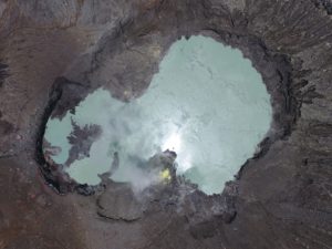
A small, short-lived explosion was detected at the Atka volcanic complex this morning at 10:34 AKDT April 25 (18:34 UTC April 25) in local infrasound and seismic data. Processing of the local infrasound data indicates the explosion originated from the summit crater of Korovin, one of several volcanoes within the Atka volcanic complex. AVO is increasing the Aviation Color Code to YELLOW and the Volcano Alert Level to ADVISORY.
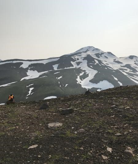
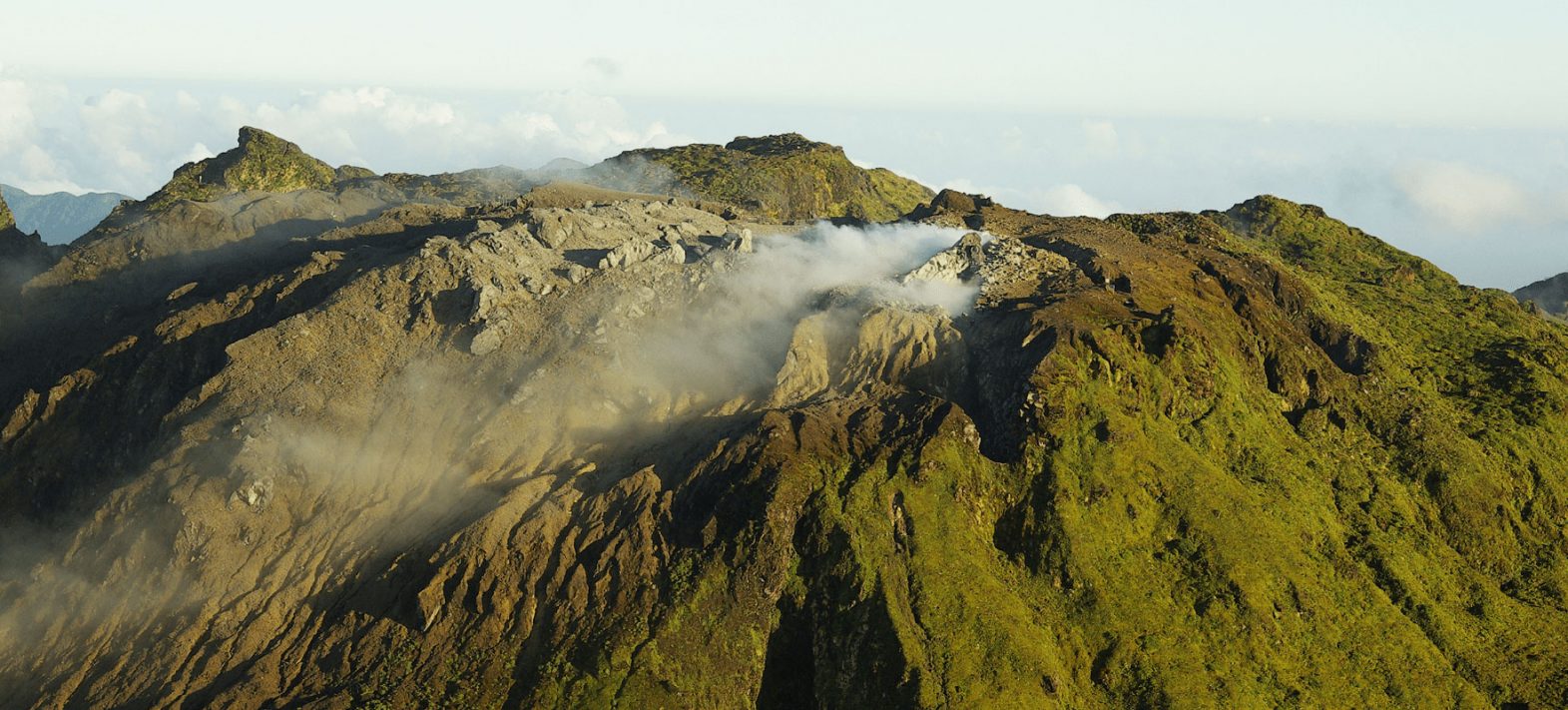
View of west flank of Kliuchef volcano, part of the Atka volcanic complex; photo taken from mid-way down the ridge line on « Big Pink ». Station 19AAJRS016. Geologist in photo is Michelle Coombs (USGS/AVO).
High clouds blocked the area at the time of the explosion, preventing satellite observations. Similar past events at the Atka volcanic complex did not result in a noticeable ashfall or ash cloud or other impacts.
Remarks:
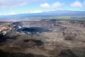
The Atka volcanic complex forms the northern part of Atka Island, located about 16 km north of the community of Atka and 1,761 km southwest of Anchorage. The Atka volcanic complex includes a possible older caldera and several younger vents, including Korovin Volcano, Mount Kliuchef, and Sarichef Volcano. Korovin Volcano, a 1553-m-high (5030 ft) stratovolcano, has been the site of most historical volcanic activity, and has a small, roiling crater lake that occasionally produces energetic steam emissions. Korovin has erupted several times in the past 200 years, including 1973, 1987, and 1998, and has likely had small ash emissions as recently as 2005. Typical recent Korovin eruptions produce minor amounts of ash and occasional but small lava flows. Reports of the height of the ash plume produced by the 1998 eruption ranged as high as 10,600 m (35,000 feet) above sea level. Mount Kliuchef is composed of a series of five vents aligned northeast–southwest. The two main summit vents of Kliuchef appear relatively young and the easternmost was probably the source of an 1812 eruption that is sometimes attributed to Sarichef.
Source : AVO
Photo : Schaefer, Janet / Alaska Volcano Observatory / Alaska Division of Geological & Geophysical Surveys
Kamchatka , Bezymianny:
VOLCANO OBSERVATORY NOTICE FOR AVIATION (VONA)
Issued: April 24 , 2025
Volcano: Bezymianny (CAVW #300250)
Current aviation colour code: ORANGE
Previous aviation colour code: red
Source: KVERT
Notice Number: 2025-25
Volcano Location: N 55 deg 58 min E 160 deg 35 min
Area: Kamchatka, Russia
Summit Elevation: 2882 m (9452.96 ft)
Volcanic Activity Summary:
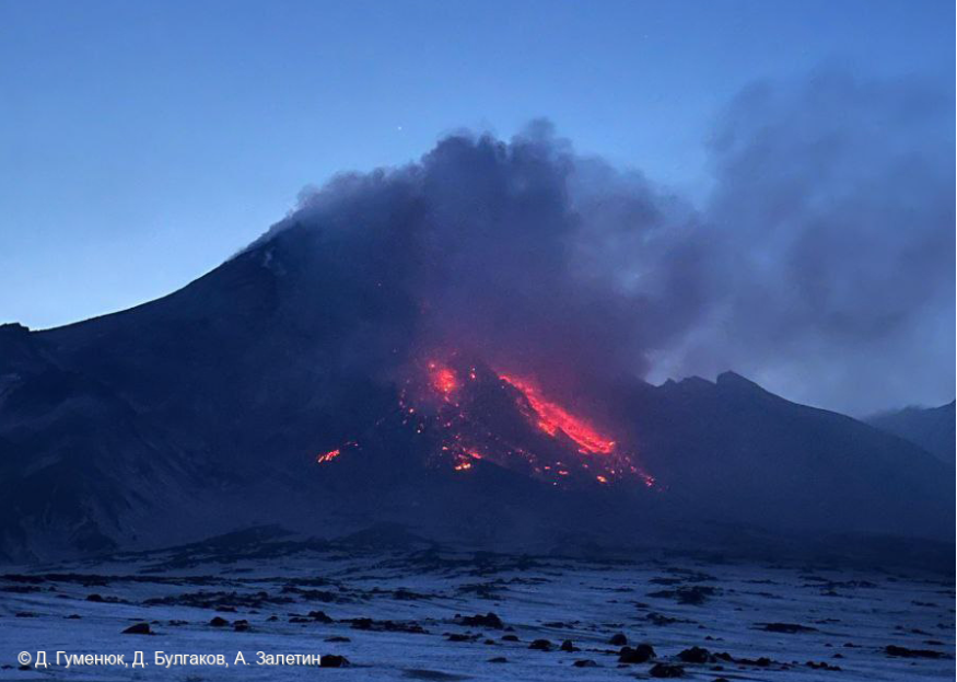
The strong explosive eruption of the Bezymianny volcano began at 23:10 UTC on 23 April, and ended about 03:00 UTC on 24 April. The explosions sent ash up to 11 km a.s.l., and ash plume extended for about 232 km from the volcano. Ashfalls were noted at Atlasovo, Lazo, Milkovo Villages. At now, no ash explosions observed at the volcano, but a large ash cloud 110×175 km in size continues to move to the southwest of the volcano. Ash cloud was noted at 7-7,5 km a.s.l., in the distance about 320 km of the volcano at 05:10 UTC on 24 April. KVERT continues to monitor the Bezymianny volcano.
The activity of the volcano continues. Ongoing activity could affect international and low-flying air craft.
Volcanic cloud height: NO ASH CLOUD PRODUSED
Other volcanic cloud information: NO ASH CLOUD PRODUSED
Source : Kvert ,
Photo : D. Gumenyuk, D. Bulgakov, A. Zaletin .
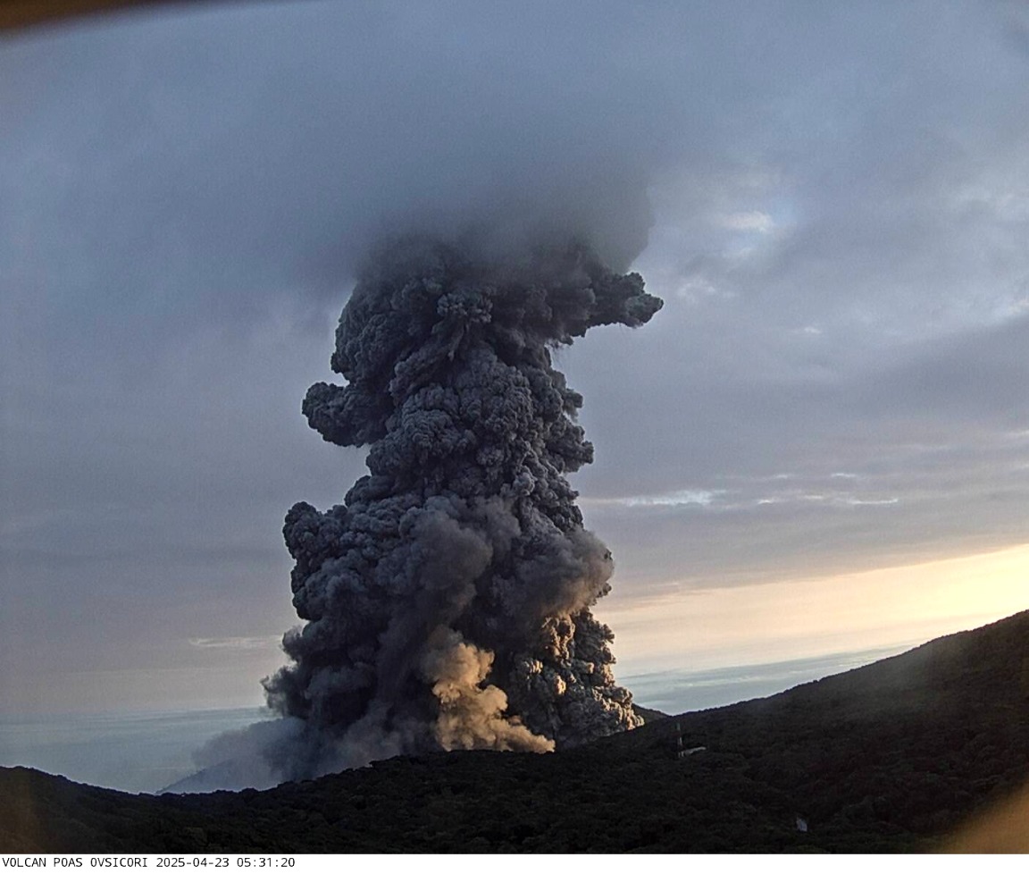
Costa Rica , Poas :
OVSICORI-UNA Weekly Volcano Monitoring Bulletin, April 25, 2025.
Lat.: 10.20°N;
Long.: 84.23°W;
Altitude: 2,687 m a.s.l.
Current Activity Level: Caution
A change in seismic patterns has been observed since April 17. Background tremor has decreased and remained at a stable baseline, with little variability to date. The only increases in tremor amplitude were related to the eruptive events of April 21 and 23, as well as an exceptional tremor on April 22, associated with minor eruptive activity at Boca C. Along with the decrease in background tremor, an increase in the number of long-period (LP) events was observed. The number of volcano-tectonic events was low, but two deep events (approximately 30 km depth) were recorded on April 21 and 23. Since April 21, occasional episodes of harmonic tremor have been recorded, the most energetic and longest-lasting being on April 23.
Acoustic activity remains virtually constant, reflecting the continuity and variability of the eruption. The eruptions of April 21 and 23 recorded the highest magnitudes recorded since 2023, 4.3 and 4.0, respectively.
The short-term variations observed in the seismic and acoustic signals prior to this week’s major eruptions are described below. On April 21, from 00:07 to 14:00, a sudden decrease in the tremor signal was observed, primarily acoustic but also seismic. During the night of April 22, an increase in seismic and acoustic tremor was observed, along with frequent acoustic pulses associated with small explosions in Mouth C. This activity abruptly ceased.
Subsequently, starting at midnight, a harmonic tremor lasting at least one hour occurred. The background tremor gradually decreased until the eruption on April 23 at 05:29.
Geodetic monitoring has detected vertical uplift and extension of the crater since December 2024, with amplitude varying weekly. Overall, the uplift of the floor north of the crater reached 3 to 4 cm, a level comparable to that observed during the 2017 eruption. In recent days, a decrease in vertical movement and extension has been recorded.
The SO2 flux measured by the DOAS station decreased this week (290 ± 122 t/d) compared to the previous week (377 ± 392 t/d). However, the wind speed and direction were not optimal for calculating this flux. Mobile DOAS measurements indicate high SO2 fluxes, ranging from 2,000 t/d to 10,000 t/d. The TROPOMI instruments on the SENTINEL satellite continue to detect significant quantities of SO2 daily. A peak was recorded on April 21 before the afternoon eruption, with values exceeding 1,000 tons of SO2. The ash emitted this week shows an increased proportion of juvenile material (fresh magma glass fragments) compared to before Easter. Ballistic projections were observed outside the crater after the April 21 eruption; the temperature of these blocks is still low. Incandescence was observed in several places each night due to sulfur combustion.
Source et photo : Ovsicori
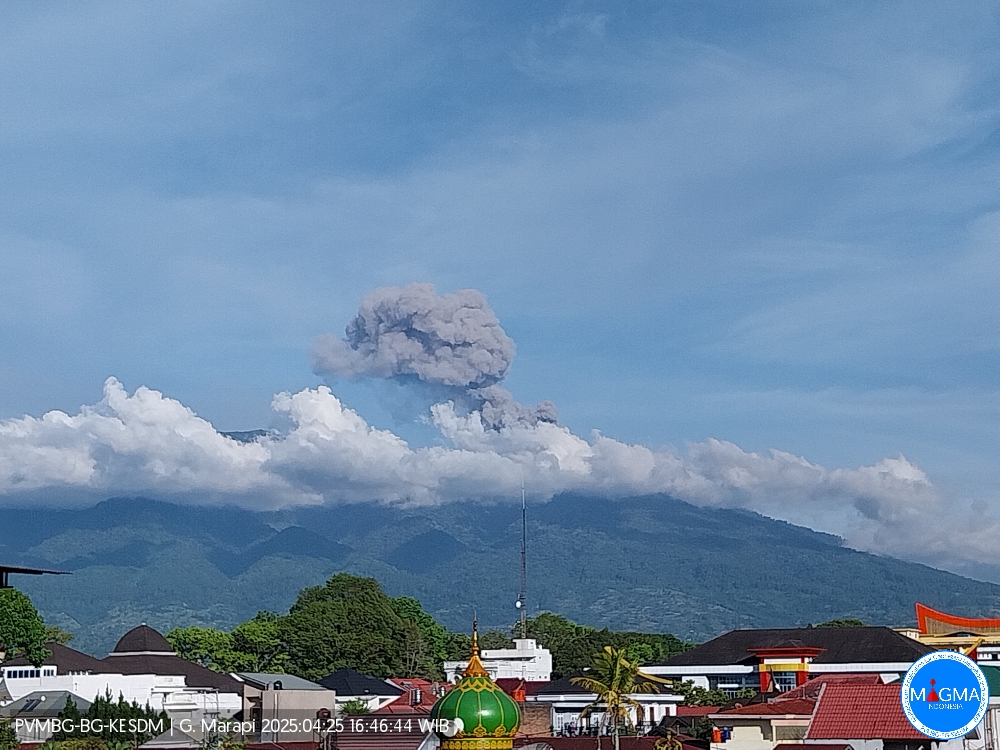
Indonesia , Marapi :
Mount Marapi erupted on Friday, April 25, 2025, at 4:41 PM WIB. The observed ash column was ± 350 m above the summit (± 3,241 m above sea level). The ash column was gray and of moderate intensity, oriented towards the north. This eruption was recorded by seismograph with a maximum amplitude of 1.2 mm and a duration of 155 seconds.
VOLCANO OBSERVATORY NOTICE FOR AVIATION – VONA
Issued : April 25 , 2025
Volcano : Marapi (261140)
Current Aviation Colour Code : YELLOW
Previous Aviation Colour Code : yellow
Source : Marapi Volcano Observatory
Notice Number : 2025MAR033
Volcano Location : S 0 deg 22 min 52 sec E 100 deg 28 min 23 sec
Area : West Sumatra, Indonesia
Summit Elevation : 9251 FT (2891 M)
Volcanic Activity Summary : Increasing in volcanic activity.
Volcanic Cloud Height :
Best estimate of ash-cloud top is around 10371 FT (3241 M) above sea level or 1120 FT (350 M) above summit. May be higher than what can be observed clearly. Source of height data: ground observer.
Other Volcanic Cloud Information :
Ash cloud moving to north. Volcanic ash is observed to be gray. The intensity of volcanic ash is observed to be medium.
Remarks :
Eruption recorded on seismogram with maximum amplitude 1.2 mm and maximum duration 155 second.
Source et photo : Magma Indonésie .
La Guadeloupe , La Soufrière :
Press release from the Paris Institute of Earth Physics / Guadeloupe Volcanological and Seismological Observatory.
Saturday, April 26, 2025 – 4:00 PM local time – 8:00 PM UTC
Earthquake sequence in the La Soufrière area of Guadeloupe – Basse-Terre
The volcanic earthquake sequence that began on Monday, April 21, 2025, at 7:00 PM local time (11:00 PM Universal Time, UT*) in the La Soufrière volcano area ended on Friday, April 25, 2025, at 5:00 AM local time (9:00 AM Universal Time, UT*).
During this sequence, the OVSG-IPGP networks recorded 563 very low magnitude earthquakes (M < 1). No felt earthquakes were reported. The events were located at a depth of < 2.5 km below the summit of the La Soufrière dome.
The alert level remains: yellow, vigilance.
Source et photo : Direction de l’OVSG-IPGP
* local time = TU – 4:00