April 04 , 2025 .
Italy / Sicily , Etna :
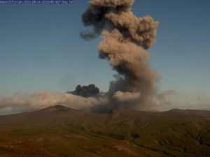
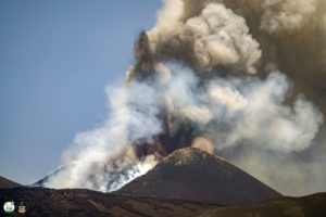
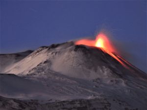
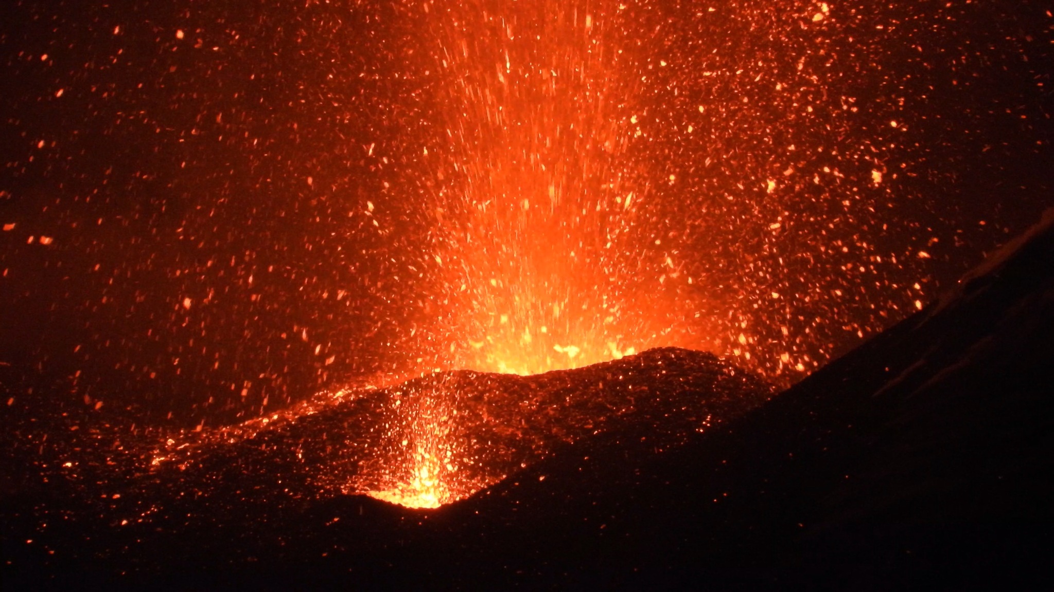
ETNA Activity Statement, March 2, 2025, 11:02 PM (9:02 PM UTC).
The National Institute of Geophysics and Volcanology, Osservatorio Etneo, reports that, starting at 8:00 PM UTC, Strombolian activity is visible in images from the INGV-OE surveillance cameras of the Southeast Crater. The forecast model indicates that any eruption clouds would disperse in an east-southeast direction.
From a seismic perspective, starting around 1:30 PM UTC, the average amplitude of volcanic tremor shows an increase, reaching the high range around 8:00 PM UTC. Currently, the values are high, with a tendency to increase further.
The centroid of the tremor sources is located in the southeast crater area at an altitude of approximately 2,800 m above sea level. Infrasound activity has also increased, and since approximately 19:30 UTC, events have been located in the southeast crater area, with amplitudes currently at high values.
Ground deformation monitoring networks are not currently showing any significant variations.
Further updates will be provided shortly.
Source : INGV
Photo : INGV Vulcani
Iceland , Reykjanes Peninsula :
Brief eruption comes to an end, but seismicity continues . Subsidence in Svartsengi has ceased
Updated April 3, at 15:25 UTC
The event is not over, as a number of small earthquakes are still being measured along the northern part of the magma intrusion.
The likelihood of a new vent opening in the northeastern part of the intrusion decreases with time.
Significant uncertainty remains regarding the continuation of this event, as a high number of small earthquakes are still detected at the northern end of the dike.
Magma flow from beneath Svartsengi into the Sundhnúkur crater row has stopped.
Deformation measurements over the coming days and weeks will shed a light on how magma accumulation beneath Svartsengi is evolving.
Deformation data indicate that the northernmost part of the dike has reached a region just under 4 km north of Keilir.
Analysis of webcam footage, drone videos, and gas measurements show that the eruption, which began at 9:44 AM on April 1st, ended around 4:45 PM the same day. The eruption lasted just over 6 hours, making it the shortest eruption in the current eruption cycle at the Sundhnúkur crater row.
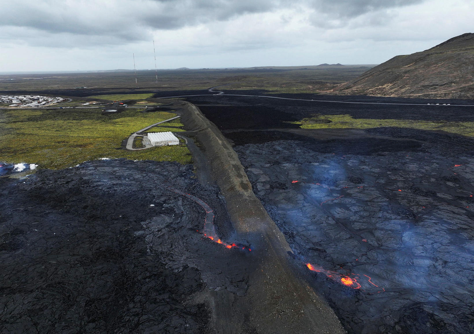
No activity has been seen at the volcanic fissure on the Sundhnúkagígaróði since midday yesterday.
However, the event is not yet over, as small earthquakes continue to be measured along the dike, particularly north of Stóra-Skógfell, although seismic activity has decreased over the past 12 hours. Little earthquake activity is recorded in the southern part of the dike.
Seismic activity has also decreased in areas such as Reykjanestá, Eldey, and Trölladyngja, where triggered seismicity has occurred in recent days.
New graben formed at the northern end of the new dike
Deformation measurements show that the northernmost part of the dike lies in an area just under 4 km north of Keilir. Satellite imagery and modeling indicate that the magma intrusion came closest to the surface about 5 km northeast of Stóra-Skógfell, where its uppermost section lies at a depth of around 1.5 km.
Satellite images also show fault movements above the northern section of the dike, in the area northeast of Litla-Skógfell, where a new graben (subsidence valley) has formed.
Fault movements have also been observed within the town of Grindavík, although to a lesser extent than those seen during the January 2024 eruption. Additionally, faulting was recorded at Reykjanestá following a magnitude 5.3 earthquake that occurred in the afternoon of April 1st.
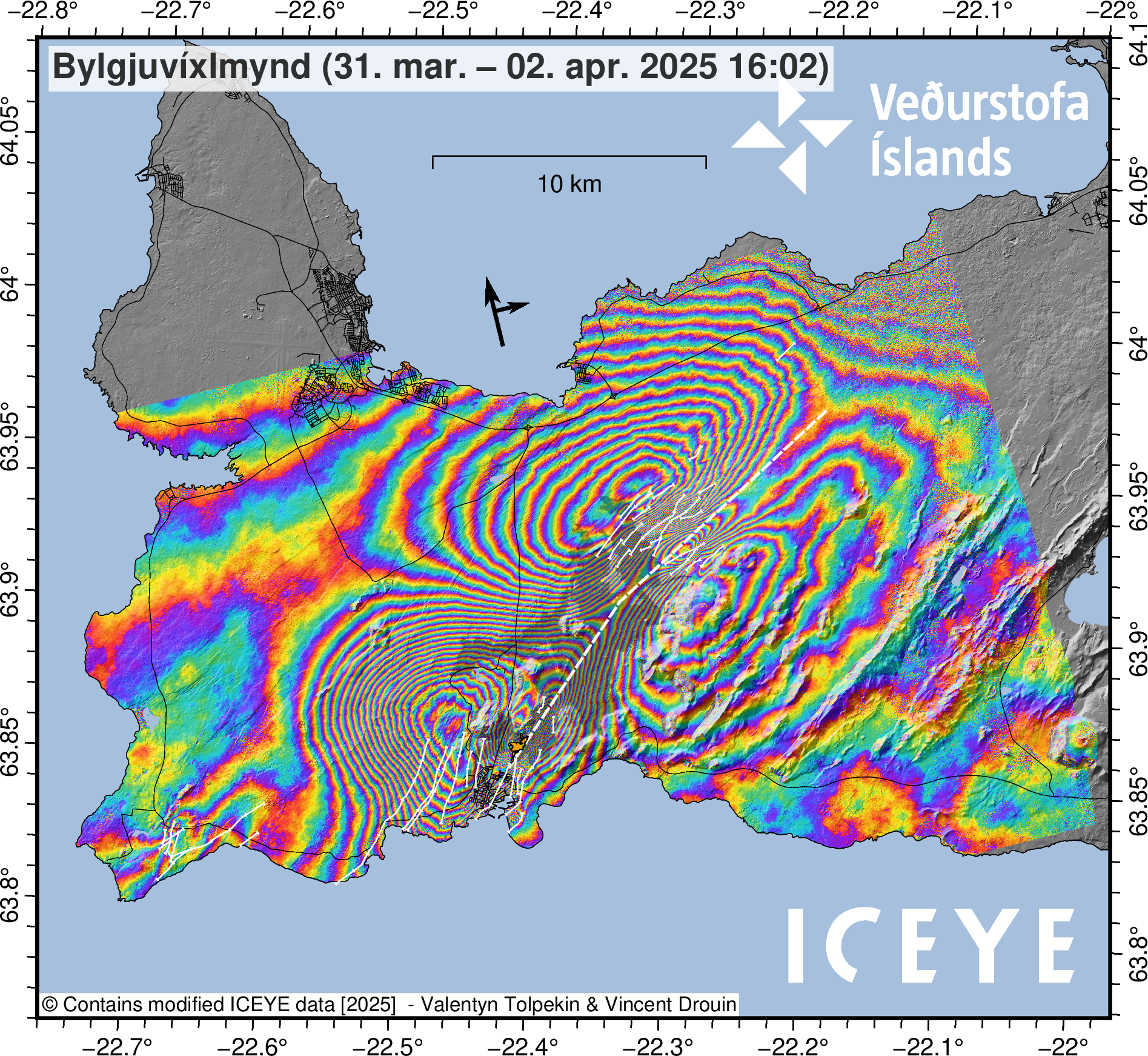
The interferogram illustrates surface deformation that occurred between March 31 and April 2. The white fault line marks the estimated location of the magma intrusion that formed on April 1. Additional white lines indicate where surface fault movements were detected. The greatest deformation has been measured in areas where the colored fringes are most tightly spaced. This includes the Svartsengi area, where the land subsided by approximately 25 cm, and on both sides of the northern part of the dike. The gray overlay shows the extent of lava flows formed since the beginning of the eruption episode in December 2023, while the orange overlay shows the lava field produced by the April 1 eruption.
Source : IMO
Photos : mbl.is/Eggert Jóhannesson , ICEYE.
Hawaii , Kilauea :
Thursday, April 3, 2025, 9:52 AM HST (Thursday, April 3, 2025, 19:52 UTC)
19°25’16 » N 155°17’13 » W,
Summit Elevation 4091 ft (1247 m)
Current Volcano Alert Level: WATCH
Current Aviation Color Code: ORANGE
Activity Summary:
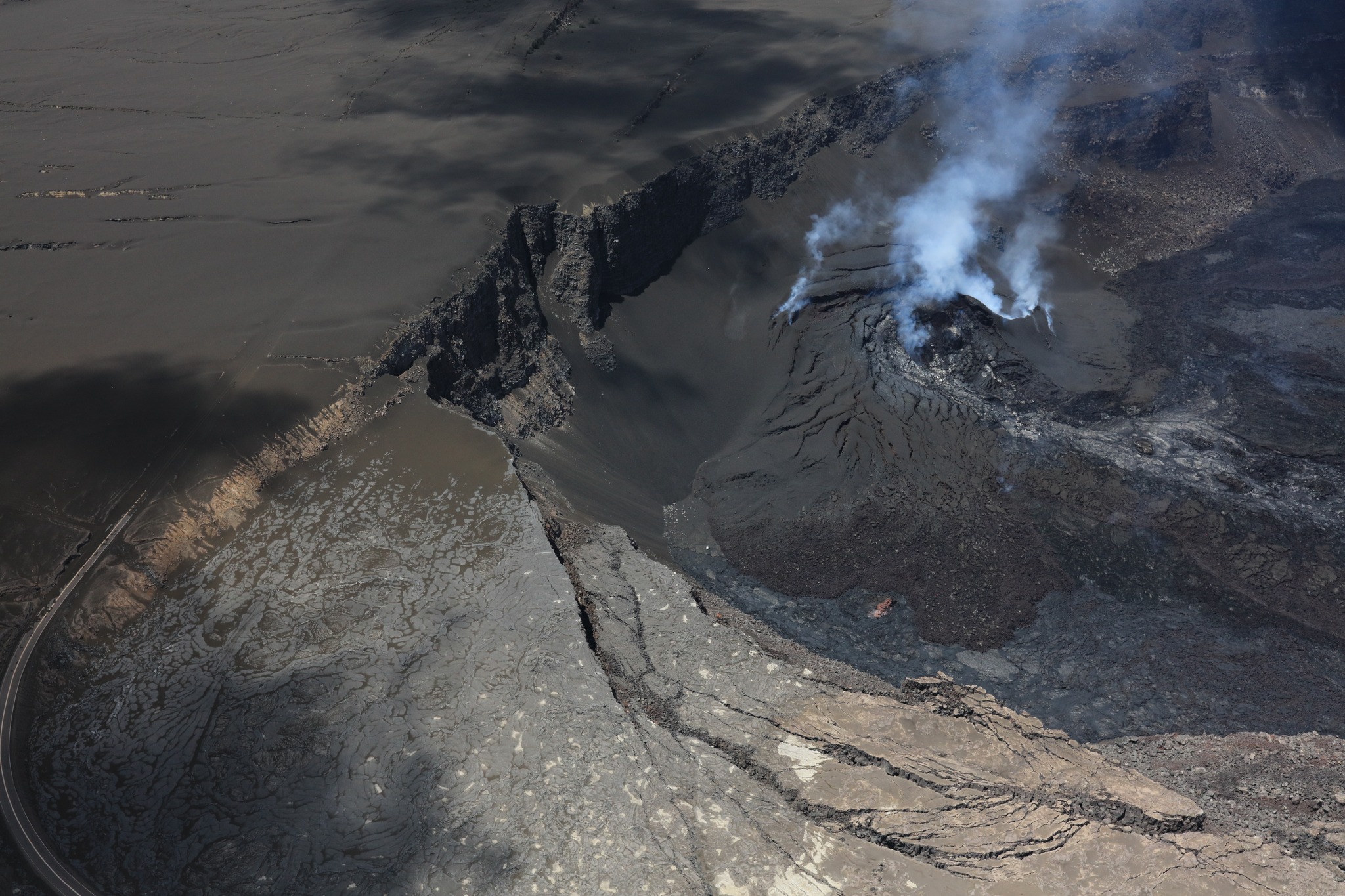
Episode 16 of the ongoing Halemaʻumaʻu eruption ended yesterday April 2 at noon HST with the end of lava fountaining. The summit magma reservoir is now reinflating suggesting that another lava fountaining episode is likely to begin later next week.
Kīlauea’s current eruption in Halemaʻumaʻu crater within Kaluapele (the summit caldera) began on December 23, 2024. There have now been 16 episodes of various degrees of fountaining separated by pauses in activity. All eruptive activity remains within Hawai’i Volcanoes National Park. No significant activity has been noted along Kīlauea’s East Rift Zone or Southwest Rift Zone.
Current hazards include volcanic gas emissions and windblown volcanic glass (Pele’s Hair) and tephra that have impacted Hawai’i Volcanoes National Park and nearby communities.
USGS Hawaiian Volcano Observatory geologists captured this view during a monitoring overflight just after noon on April 2, 2025, following the end of episode 16 of the ongoing eruption in Halemaʻumaʻu. The closed portion of Crater Rim Drive in Hawaiʻi Volcanoes National Park is visible in the lower left part of the image, and by following the road path, you can see how tephra in the ongoing eruption has buried it. The degassing north and south vent are visisble in the right center area of the image, and they have built an impressive cone feature within Halemaʻumaʻu crater.
Summit Observations:
Lava fountaining began diminishing yesterday morning at about 9:50 a.m. HST, stopping completely at 12:03 p.m. HST ending episode 16. A thick, white plume of gas has been present at the vent craters since then. Glow was also visible overnight from the south vent and seismic tremor remains elevated, similar to earlier pauses. Small spatter events in the south vent were observed late yesterday afternoon after fountaining ended. Similar events have not prevously been reported after fountaining episodes but suggest that magma remains high in the vent conduit. This morning, bright sulfur deposits are visible on the vent cones. Additionally, weak, residual lava flows continue to be active on the eastern crater floor overnight as small ooze-outs.
The UWD and SDH tiltmeters recorded an abrupt switch to inflationary tilt just after noon, when the fountaining ceased. Tilt increased by 1.5 to 2 microradians indicating repressurization of the summit magma reservoir is taking place.
Volcanic gas emissions remain elevated, though reduced from the levels associated with lava fountaining. SO2 emission rates during earlier pauses have been approximately 1000 t/d. This morning, the plume is being carried towards the north, similar to the wind direction of yesterday.
Strands of volcanic glass known as Pele’s Hair from previous episodes are still present throughout the summit area of Hawai’i Volcanoes National Park and surrounding communities and can be remobilzed by wind if present.
Source : HVO
Photo : USGS / K. Lynn.
Indonesia , Marapi :
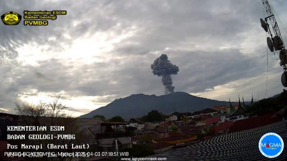
ERUPTION OF MOUNT MARAPI, WEST SUMATRA, APRIL 3, 2025 AT 07:12 WIB.
Mount Marapi erupts frequently. Since 1807, the eruption has had the shortest dormant period of less than a year and the longest of 17 years (average dormant period of 3.5 years). Since 1987, eruptions have been explosive, originating from the Verbeek crater. Eruptive activity is usually accompanied by a rumbling or roaring sound, with eruption products in the form of ash and lapilli, sometimes also followed by the ejection of incandescent material and volcanic bombs.
Discontinuous eruptions continue to this day due to the dynamics of fluid/magma inflow from deep within Mount Marapi. On April 3, 2025 at 07:12 WIB, an eruption occurred, which was recorded on a seismograph with a maximum amplitude of 30.4 mm and a duration of 1 minute 9 seconds. The ash and smoke column from the eruption was observed from the observation post at a height of 1,500 meters above the summit. Before this eruption occurred, observation data showed an influx of fluid/magma from the depths, as indicated by the recording of 4 deep volcanic earthquakes on March 27, 2025, and 15 shallow volcanic earthquakes on April 1, 2025.
The eruptions of Mount Marapi are thought to have occurred due to the opening and closing of the vent at the bottom of Verbeek Crater. As the lava hardens due to the cooling process (which may be accelerated by the inflow of meteoric water), the vent closes, preventing magmatic gas from escaping into the atmosphere. This leads to a buildup of pressure in the shallow part near the surface. Then, when the pressure saturation limit is exceeded, an eruption (energy release) occurs, and the vent reopens. Such processes are repeated, and as long as the dynamics of fluid/magma inflow from the depths continue, eruptions can occur again.
Current seismic velocity variation and coherence data are decreasing again, indicating that the stress on the volcanic body is increasing again and that the state of the environment near the volcano’s surface is unstable. Therefore, the potential for an eruption still exists and could occur at any time in the form of energy release, with a potential hazard of ejection of eruption material estimated within a 3 km radius of the activity center (Verbeek Crater) of Mount Marapi.
Based on the analysis and evaluation of comprehensive monitoring data, the activity level of Mount Marapi remains at Level II (WASPADA).
Source et photo : PVMBG
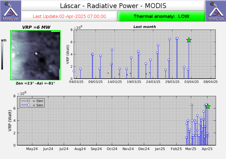
Chile , Lascar :
Special Volcanic Activity Report (REAV), Antofagasta region, Láscar Volcano. April 2, 2025, 6:30 a.m. local time (Continental Chile)
The National Geology and Mining Service of Chile (Sernageomin) publishes the following information, obtained using monitoring equipment from the National Volcanic Monitoring Network (RNVV), processed and analyzed at the Southern Andean Volcanological Observatory (OVDAS).
On Wednesday, April 2, 2025, the MIROVA platform ( www.mirovaweb.it) reported a 6.2 MW satellite thermal anomaly, detected by the MODIS sensor, originating from the active crater. Meanwhile, Sentinel 2-L2A satellite images updated through March 28, 2025, continue to record three areas of thermal radiation within the active crater, a pattern that has been occurring since February 6 of this year.
Surveillance cameras installed around the volcano recorded a slight incandescence during the night. However, the seismological network installed on the volcano has recorded a decrease in Long Period (LP) activity since early February.
The current dynamics of the Láscar volcano present a state of instability in its surface activity, which could eventually lead to the occurrence of minor explosions with an impact limited to the proximal area of the active crater, and to the emission of pyroclastic material from low-energy eruptive columns.
The technical alert for this volcanic system remains at yellow.
Source : Sernageomin