April 01 , 2025.
Costa Rica , Poas :
Daily Volcano Status Report. OVSICORI-UNA, Date: March 31, 2025, Updated at: 12:00:00.
Latitude: 10.2
Longitude: -84.233
Height: 2,687 meters above sea level
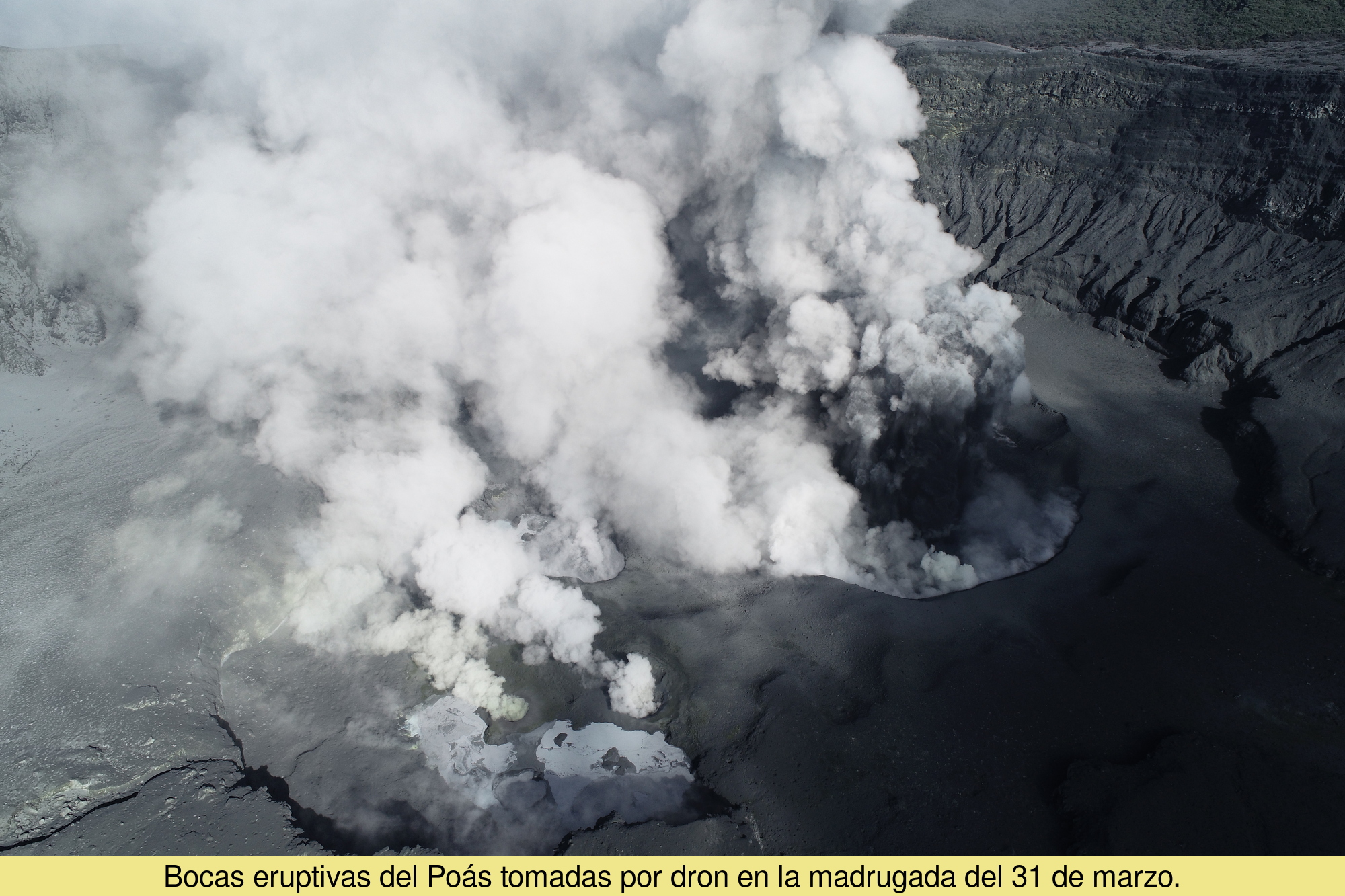
Observed Activity:
Eruptions are continuing, with a steady emission of dry ash.
An explosion occurred at 12:50 a.m., projecting material to a height of over 600 meters.
The ash is being deposited mainly towards the southwest. Yesterday, more than half a centimeter of ash was found at the Visitor viewpoint.
The VT-type events recorded yesterday have diminished.
The outgassing is still very strong. Yesterday, due to the midnight eruption, a very high peak of SO2 accumulation in the atmosphere over the country was recorded (2,200 tons).
Environmental Conditions:
The sky became cloudy during the morning. The wind is light.
Activity Level: Caution (3)
Source : Ovsicori.
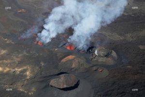
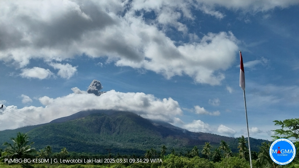
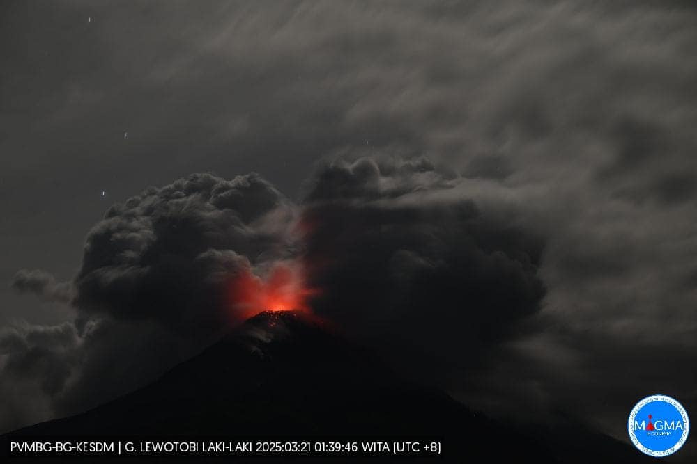
Indonesia , Lewotobi Laki – Laki :
Results of visual and seismic observations of Lewotobi Laki-Laki from March 22 to 30, 2025:
Seismicity recorded during the period from March 22 to 30, 2025:
2 eruption earthquakes,
102 emission earthquakes,
88 harmonic tremors,
2 low-frequency earthquakes,
11 deep volcanic earthquakes,
8 local tectonic earthquakes,
37 distant tectonic earthquakes.
Visual observations for the period from March 22 to 30, 2025, show that volcanic activity at Lewotobi Laki-Laki experienced a very significant decrease. The average height of the eruption columns was not visible, and according to the data, it decreased significantly compared to the previous period, which reached 1,000 to 8,000 meters. Incandescence is still faintly visible around the summit, indicating the possibility that incandescent material may still be present at shallow depths.
There are deposits of material that could potentially become lahars in the west-northwest and north-northeast areas of the Lewotobi Laki-Laki crater.
During this period, the seismic burst dropped quite significantly, indicating that there is still internal pressure capable of erupting. Smoke is erupting around the crater with low, visible pressure.
The length of the flow deposits in the northwest direction is still stable at a distance of approximately 3.8 km, while the length of the lava flow in the northeast direction is 4.2 km from the summit. The influence of the slope still allows the lava to move.
Seismic tremor during this period has decreased quite significantly, indicating a reduction in pressure that is forcing material out of the crater. If an eruption occurs in the future, the potential will be dominated by eruptions of ash-like material.
Harmonic tremor still fluctuates regularly, as in the previous period, indicating that there are vibrations due to fluid movement (magma/gas/water vapor) beneath Lewotobi Laki-Laki. Fluid movement or gas release from the magma tends to be the same but is still moving shallower toward the surface. During this period, no Tornillo-type earthquakes were recorded compared to the previous period. This indicates that the fluid filling the fracture in the fault zone is decreasing, so the eruption intensity is likely to decrease in the future.
Low-frequency earthquakes tend to decrease, indicating that the flow of magmatic fluid from the conduit to the surface at medium to shallow depths is decreasing.
No shallow volcanic earthquakes were recorded during this period, indicating that the intensity of magmatic activity in the magma chamber of Lewotobi Laki-laki volcano has decreased, so the eruption potential will be lower than before.
The number of volcanic tremors has decreased significantly, indicating that the intensity of magmatic activity in the magma chamber of Lewotobi Laki-laki volcano has decreased.
Local tectonic earthquakes have decreased significantly compared to the previous period, consistent with the reduction in volcanic tremor at Mount Lewotobi Laki-laki. The local tectonic hypocenter around Mount Ile Muda likely indicates that there is still input from the interior, which is still far from the body of Mount Lewotobi Laki-laki. Both local and distant tectonic earthquakes affect the activity of Mount Lewotobi Laki-laki. Therefore, it is necessary to be vigilant if there is a sudden increase in the number of these two types of tectonic earthquakes, particularly local tectonic earthquakes, which will affect the height of the eruption or the activity of Mount Lewotobi Laki-laki.
Flood vibrations were no longer recorded as the rainfall intensity decreased around Mount Lewotobi Laki-laki. It is important to be aware that the material released by the eruption and deposited around Mount Lewotobi Laki-laki can potentially become lahars during heavy rainfall.
Based on the results of a thorough analysis and evaluation of visual and instrumental monitoring, the activity level of Lewotobi Laki-laki is upgraded from Level IV (AWAS) to Level III (SIAGA) as of March 30, 2025 at 12:00 WITA
Source : PVMBG
Photos : Magma Indonésie .
Alaska , Katmai :
AVO Information Statement , Monday, March 31, 2025, 12:22 PM AKDT
Current Volcano Alert Level: NORMAL
Current Aviation Color Code: GREEN
Strong northwesterly winds in the vicinity of Katmai and the Valley of Ten Thousand Smokes have picked up loose volcanic ash erupted during the 1912 Novarupta-Katmai eruption and are carrying it to the southeast toward Kodiak Island. This phenomenon is NOT related to Mount Spurr. The National Weather Service has issued a SIGMET for this low-level event and suggests that the maximum cloud height is 4,000 ft (1.2 km) above sea level.
Novarupta dome, the site of the 1912 eruption that created the Valley of Ten Thousand Smokes. June 2006
This phenomenon is not the result of recent volcanic activity and occurs during times of high winds and dry snow-free conditions in the Katmai area and other young volcanic areas of Alaska. No eruption is in progress. All of the volcanoes of the Katmai area (Griggs, Katmai, Novarupta, Mageik, Martin, Snowy and Trident) remain at Aviation Color Code GREEN and Alert Level NORMAL. Resuspended volcanic ash should be considered hazardous and could be damaging to aircraft and health.
Source : AVO
Photo : P. Izbekov, AVO/UAF-GI. USGS, DGGS .
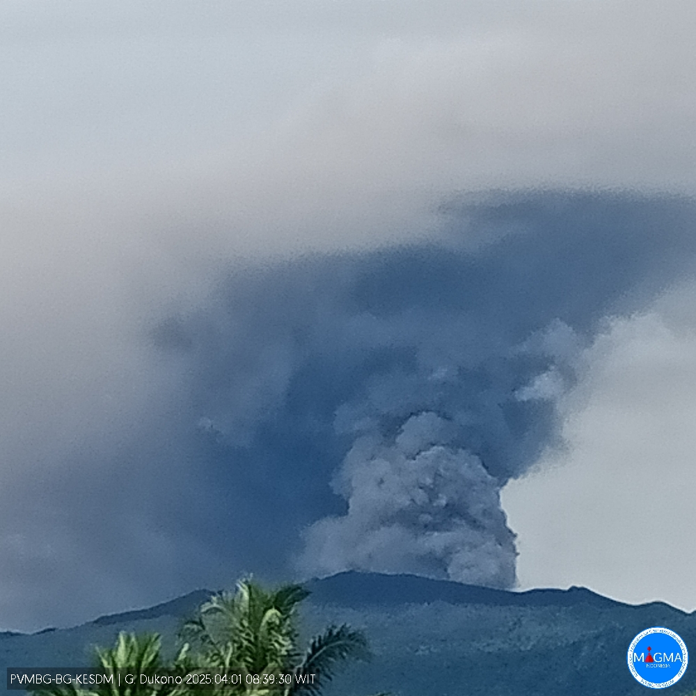
Indonesia , Dukono :
An eruption of Mount Dukono occurred on Tuesday, April 1, 2025, at 08:10 WIT with an observed ash column height of ± 1000 m above the peak (± 2087 m above sea level). The ash column was observed to be white to gray in color with a thick, south-facing intensity. At the time of writing, the eruption was still ongoing.
VOLCANO OBSERVATORY NOTICE FOR AVIATION – VONA
Issued : April 01 , 2025 .
Volcano : Dukono (268010)
Current Aviation Colour Code : ORANGE
Previous Aviation Colour Code : orange
Source : Dukono Volcano Observatory
Notice Number : 2025DUK049
Volcano Location : N 01 deg 41 min 35 sec E 127 deg 53 min 38 sec
Area : North Maluku, Indonesia
Summit Elevation : 3478 FT (1087 M)
Volcanic Activity Summary :
Eruption with volcanic ash cloud at 23h10 UTC (08h10 local).
Volcanic Cloud Height :
Best estimate of ash-cloud top is around 6678 FT (2087 M) above sea level or 3200 FT (1000 M) above summit. May be higher than what can be observed clearly. Source of height data: ground observer.
Other Volcanic Cloud Information :
Ash cloud moving to south. Volcanic ash is observed to be white to gray. The intensity of volcanic ash is observed to be thick.
Remarks :
Eruption and ash emission is continuing. Eruption recorded on seismogram with maximum amplitude 24 mm. Tremor recorded on seismogram with maximum amplitude 4 mm.
Source et photo : Magma Indonésie.
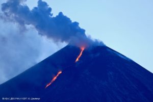
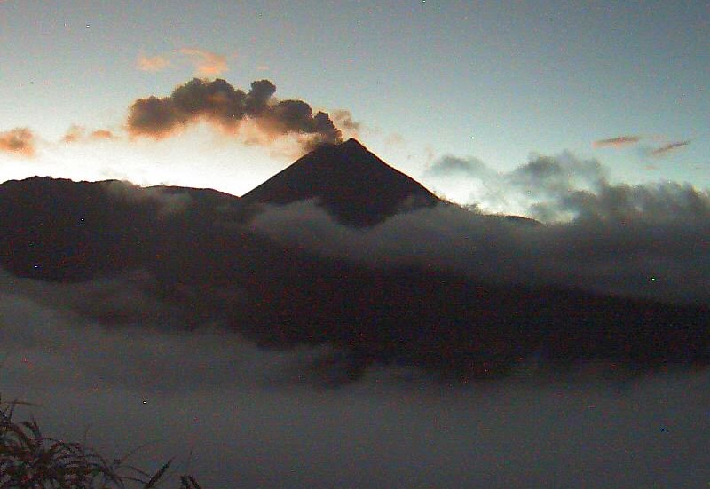
Ecuador , El Reventador .
DAILY STATUS REPORT OF REVENTADOR VOLCANO, Monday, March 31, 2025.
Information Geophysical Institute – EPN.
Surface Activity Level: High, Surface Trend: Descending
Internal Activity Level: Moderate, Internal Trend: No change
From March 30, 2025, 11:00 a.m. to March 31, 2025, 11:00 a.m.:
Seismicity:
Below is the count of seismic events recorded at the reference station.
Explosion (EXP) 100
Long Period (LP) 11
Emission Tremor (TREMI) 20
Harmonic Tremor (TRARM) 0
Rainfall/Lahars:
From yesterday until this morning, according to meteorological sources, no rain was recorded on the volcano and its surroundings, and no mud or debris flows were generated. **In the event of more intense rainfall in the area, it could remobilize the accumulated material and generate mud and debris flows that would descend the flanks of the volcano and flow into adjacent rivers.
Emission/Ash Column:
From yesterday afternoon until this morning, surveillance cameras and satellite monitoring recorded several gas and ash emissions ranging from 400 to 1,000 meters above the crater, toward the west, northwest, and southwest.
Similarly, the Washington-based VAAC agency has published three reports reporting this activity.
Other monitoring parameters:
The FIRMS and MIROVA-VIIRS satellite systems recorded three thermal anomalies and two low thermal anomalies, respectively, over the past 24 hours.
Observation:
Over the past 24 hours, several episodes of incandescent material were observed descending the volcano’s flanks, reaching 500 to 800 meters below the crater level. However, the volcano remained partly cloudy to completely cloudy.
Alert Level – SGR: Orange
Source : IGEPN
Photo : archive igepn