March 24 , 2025.
Indonesia , Merapi :
MERAPI ACTIVITY REPORT, March 14–20, 2025
OBSERVATION RESULTS
Visual
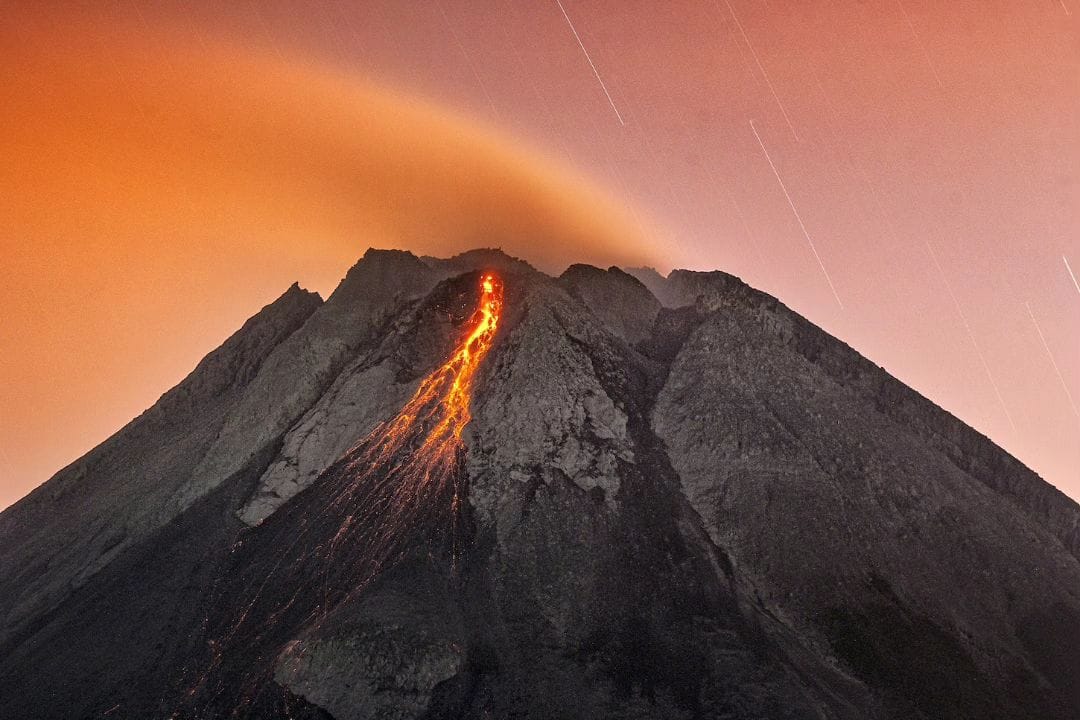
The weather around Mount Merapi is generally sunny in the morning and evening, while it is hazy during the day. White smoke, thin to thick, with low to moderate pressure, with a smoke height of 150 m was observed from the Mount Merapi observation post in Kaliurang on March 15, 2025, at 05:30 WIB.
This week, there were two warm cloud avalanches to the southwest (upstream of the Krasak River) with a maximum sliding distance of 1,800 m. Lava avalanches were observed 31 times upstream of the Bebeng River up to a maximum of 1,800 m, 29 times upstream of the Krasak River over 1,800 m, 29 times westward of the Sat/Putih River up to a maximum of 1,900 m, and once upstream of the Boyong River up to 1,200 m.
The morphology of the southwest dome has undergone slight changes due to hot cloud activity and lava flows. No significant morphological changes were observed for the central dome. According to an analysis of aerial photos dated March 11, 2025, the volume of the southwest dome is 3,626,200 m3. Meanwhile, the volume of the central dome is measured at 2,368,800 m3.
Seismicity:
This week, Mount Merapi’s seismic activity recorded:
2 Warm Cloud Avalanche (WCA) earthquakes,
8 Shallow Volcanic Earthquakes (SV),
692 Multiphase Earthquakes (MP),
996 Avalanche Earthquakes (RF),
9 Tectonic Earthquakes (TT).
The intensity of the earthquakes this week remains quite high.
Deformation
The deformation of Mount Merapi, monitored using EDM and GPS this week, showed no significant changes.
Rainfall and Lahars
This week, it rained at the Mount Merapi observation post, with the highest rainfall intensity of 27 mm/hour for 122 minutes at the Kaliurang observation post on March 17, 2025. There were no reports of additional discharge or lahars in rivers originating from Mount Merapi.
Conclusion
Based on the results of visual and instrumental observations, it is concluded that:
Mount Merapi’s volcanic activity is still quite high in the form of effusive eruptions. The activity status is defined as « SIAGA » level.
Source : BPPTKG
Photo : Merapi news / FB ( 12/07/2024)
Chile , Tupungatito :
Special Report on Volcanic Activity (REAV), Metropolitan Region of Santiago, Tupungatito Volcano, March 23, 2025, 11:35 PM local time (Continental Chile).
The National Geology and Mining Service of Chile (SERNAGEOMIN) publishes the following preliminary information, obtained using the monitoring equipment of the National Volcanic Monitoring Network (RNVV), processed and analyzed at the Southern Andean Volcanological Observatory (OVDAS):
On Sunday, March 23, 2025, at 11:17 PM local time (March 24, 02:17 UTC), monitoring stations installed near the Tupungatito Volcano recorded an earthquake associated with rock fracturing (volcano-tectonic type).
The earthquake characteristics after analysis are as follows:
TIME OF ORIGIN: 23:17 local time (24/03/2025 – 02:17 UTC)
LATITUDE: 33.258° S
LONGITUDE: 69.782° W
DEPTH: 1.2 km
LOCAL MAGNITUDE: 3.6 (ML)
OBSERVATIONS:
At the time of this report, no other earthquakes had been recorded.
The Volcanic Technical Alert remains at Green.
Source et photo : Sernageomin
Hawaii , Kilauea :
Sunday, March 23, 2025, 9:55 AM HST (Sunday, March 23, 2025, 19:55 UTC)
19°25’16 » N 155°17’13 » W,
Summit Elevation 4091 ft (1247 m)
Current Volcano Alert Level: WATCH
Current Aviation Color Code: ORANGE
Activity Summary:
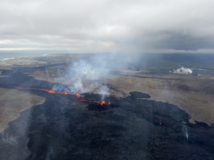
Episode 14 of the ongoing Halemaʻumaʻu eruption at Kīlauea’s summit ended at 1:49 p.m. HST on March 20 and the eruption is currently paused. Episode 15 is likely to begin late today or tomorrow in Hawai’i Volcanoes National Park.
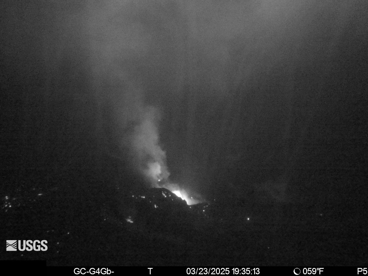
Summit Observations:
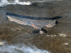
Episode 14 lasted 28 hours and 23 minutes with the last 7 hours and 19 minutes consisting of fountains up to 600 feet (180 meters) high predominantly from the south vent. Lava flows and fountains stopped erupting from the south vent within Halemaʻumaʻu crater at 1:49 p.m. HST on March 20. Fountains from the north vent ceased 11 minutes earlier. Lava flows from episode 14 covered 75% of the Halemaʻumaʻu crater floor. Spots of orange glow can still be seen on the crater floor at night as the erupted lava continues to cool. The vents continue to degas and glow at night, indicating magma remains at shallow levels in the vent. A detailed account of the eruption can be found in the Kīlauea update and the Status Report from March 20.
Deflationary tilt at the summit recorded about 6 microradians lost during this episode using the the Uēkahuna (UWD) tiltmeter. The UWD tiltmeter has since experienced instrument malfunction and is not accurately recording tilt. The Sandhill (SDH) tiltmeter is now being used to track summit deformation. The SDH tiltmeter has recorded inflationary tilt that is about 75% of the tilt lost during episode 14. Seismic tremor decreased significantly at the end of episode 14 but remains above background.
Volcanic gas emissions remain elevated. A maximum sulfur dioxide (SO2) emission rate measured in the morning on March 20 reached approximately 50,000 t/d. Based on measurements made during earlier episodes and pauses, SO2 emission rates are likely to be approximately 1,000 t/d during the current pause. An SO2 emission rate of 1,500 t/d was measured on March 20 at 5:00 p.m. HST.
Source et photo : HVO
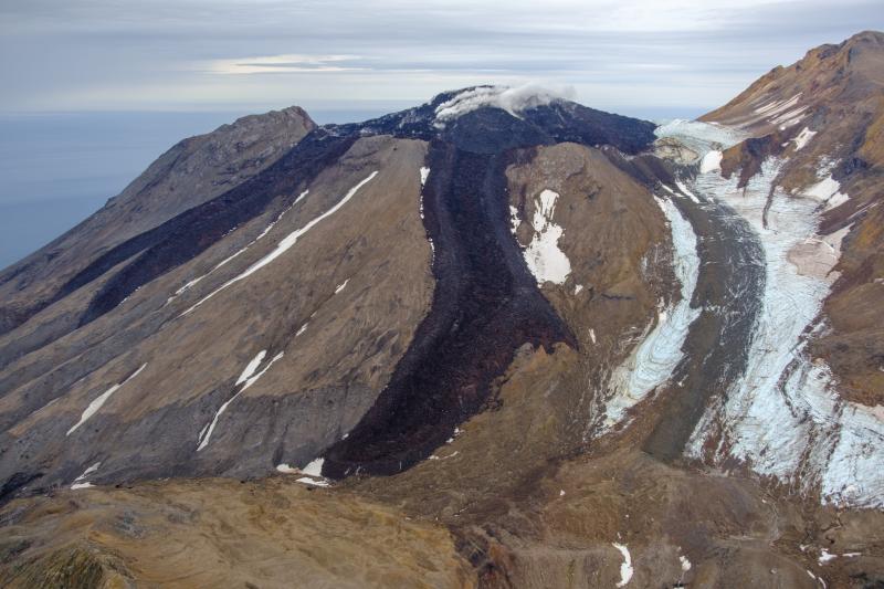
Ecuador , El Reventador .
DAILY STATUS REPORT OF REVENTADOR VOLCANO, Sunday, March 23, 2025.
Information Geophysical Institute – EPN.
Surface Activity Level: High, Surface Trend: No change
Internal Activity Level: Moderate, Internal Trend: No change
From March 22, 2025, 11:00 a.m. to March 23, 2025, 11:00 a.m.:
Seismicity:
Below is the count of seismic events recorded at the reference station.
Explosion (EXP) 60
Long Period (LP) 11
Emission Tremor (TREMI) 32
Harmonic Tremor (TRARM) 0

Rainfall/Lahars:
Last night and this morning, according to meteorological media, rainfall was recorded on the volcano and its surroundings, but it did not generate mudflows or debris flows. **If more intense rainfall occurs in the region, it could remobilize accumulated material and generate mud and debris flows that would descend the volcano’s flanks and drain into adjacent rivers.
Emission/Ash Column:
Yesterday, gas and ash emissions were observed using surveillance cameras and satellite images at altitudes between 300 and 700 meters above the crater in a southwesterly direction. Furthermore, the VAAC agency in Washington has not published any reports in the last 24 hours.
Observation:
Over the past 24 hours, several episodes of incandescent material falling on the volcano’s flanks have been observed, reaching 800 meters below the crater. However, the volcano remained cloudy.
Alert Level – SGR: Orange
Source : IGEPN
Photo : 02/11/2024 04:29, Benjamin Bernard / volcanesdelecuador
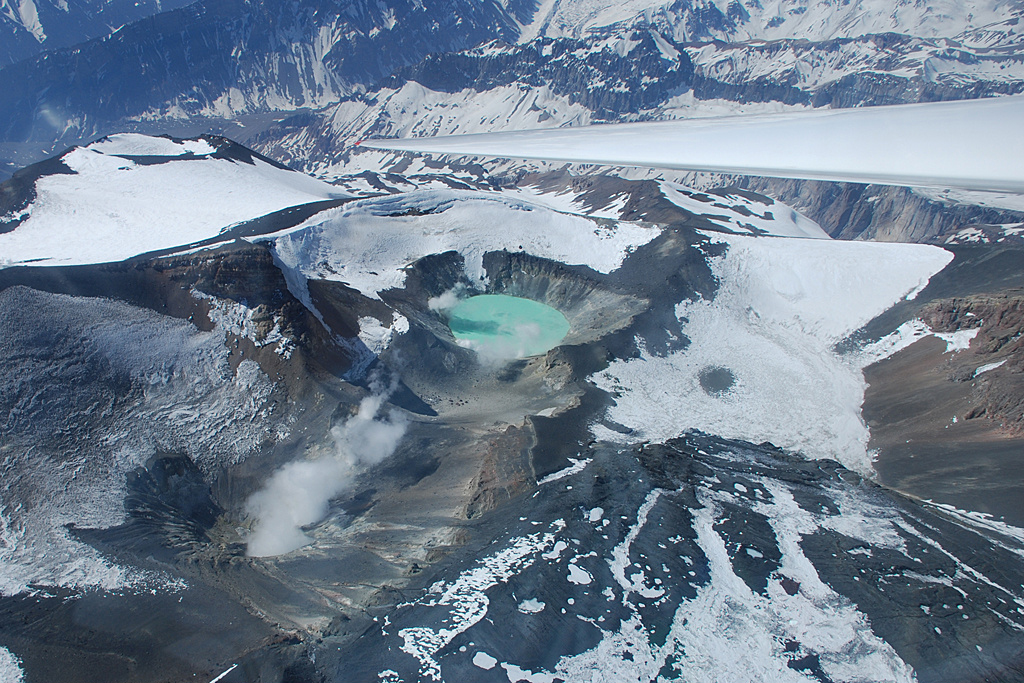
Alaska , Great Sitkin :
52°4’35 » N 176°6’39 » W,
Summit Elevation 5709 ft (1740 m)
Current Volcano Alert Level: WATCH
Current Aviation Color Code: ORANGE
Activity at Great Sitkin Volcano continued over the past week, characterized by the slow eruption of lava in the summit crater. Satellite radar data through March 18 shows ongoing slow growth of the lava flow. Intermittent, small volcanic earthquakes continue to occur. The volcano has been obscured by clouds in satellite and web camera views all week.
Since the May 2021 explosion, there have been no other explosions at Great Sitkin Volcano. The lava eruption that began in July 2021 is ongoing. It has filled most of the summit crater and advanced into valleys below. The volcano is monitored using local seismic and infrasound sensors, satellite data and web cameras, and regional infrasound and lightning networks.
Great Sitkin Volcano is a basaltic andesite volcano that occupies most of the northern half of Great Sitkin Island, a member of the Andreanof Islands group in the central Aleutian Islands. It is located 26 miles (42 km) east of the community of Adak. The volcano is a composite structure consisting of an older dissected volcano and a younger parasitic cone with a ~1 mile (1.6 km)-diameter summit crater. A steep-sided lava dome, emplaced in the crater during an eruption in 1974, has been mostly buried by the ongoing eruption. The 1974 eruption produced at least one ash cloud that likely exceeded an altitude of 25,000 ft (7.6 km) above sea level. A poorly documented eruption also occurred in 1945, producing a lava dome that was partially destroyed in the 1974 eruption. Within the past 280 years a large explosive eruption produced pyroclastic flows that partially filled the Glacier Creek valley on the southwest flank.
Source : AVO
Photo : Loewen, Matt / Alaska Volcano Observatory / U.S. Geological Survey