March 19 , 2025.
Italy / Sicily , Etna :
WEEKLY BULLETIN, from March 10, 2025 to March 16, 2025 (issue date March 18, 2025)
ACTIVITY SUMMARY
Based on monitoring data, the following are highlighted:
1) VOLCANOLOGICAL OBSERVATIONS: Variable rate degassing activity from the summit craters. Strombolian activity at the Southeast crater.
2) SEISMOLOGICAL OBSERVATIONS: No seismic activity due to fracturing with Ml>=2.0; tremor amplitude remained mainly at average levels.
3) INFRASOUND: Low infrasound activity.
4) GROUND DEFORMATION: Over the past week, ground deformation monitoring networks have not recorded any significant changes. 5) GEOCHEMISTRY: SO2 flux at a medium level and increasing towards a medium-high level.
Soil CO2 flux (Etna Gas Network) decreasing while remaining within average values.
The partial pressure of dissolved CO2 in the aquifer (Ponteferro) shows values within seasonal variability.
Helium isotope ratio at peripheral sites: Latest data (11/03/2025) show medium-high values.
6) SATELLITE OBSERVATIONS: Thermal activity observed by satellite in the summit area was generally low, with some isolated moderate thermal anomalies.
7) OTHER OBSERVATIONS: Whole-rock analysis of samples collected from February 10 to 24, 2025, indicates that the composition of the magma has changed slightly over time.
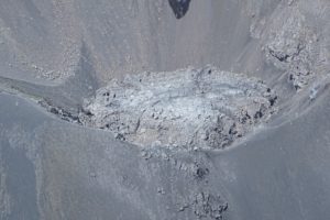
VOLCANOLOGICAL OBSERVATIONS
During the observation period in question, monitoring of Etna’s volcanic activity was carried out by analyzing images from the INGV surveillance camera network, Osservatorio Etneo (INGV-OE).
Due to cloud cover, observation of volcanic activity by the cameras was severely limited and intermittent.
Overall, during periods of visibility, Etna’s activity was observed to be characterized by continuous degassing of varying intensity and regime within individual craters.
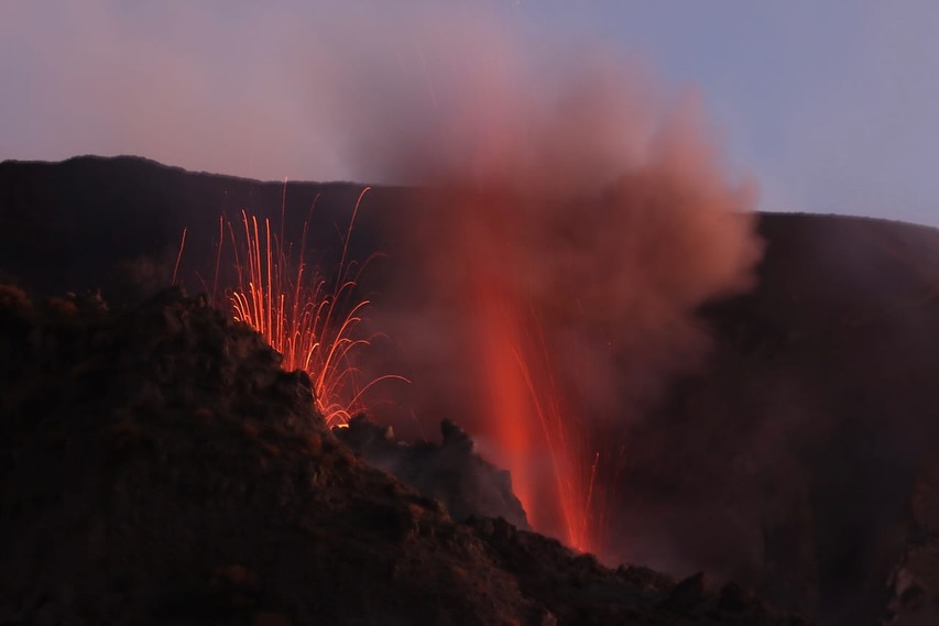
On the evening of Saturday, March 15, starting at 19:18 UTC, a resumption of Strombolian activity was observed in the Southeast Crater. In its initial phases, the activity remained confined to the crater, with fragments ejected within it. Beginning around 23:00 UTC, the activity gradually increased in intensity and explosion frequency, with repeated projections of incandescent material beyond the crater rim and along the sides of the cone, all the way to its base.
The activity peaked around 00:05 UTC on Sunday, March 16, then gradually decreased from 01:15 UTC and ceased completely at 02:20 UTC.
Source : INGV
Photo : Dario Lo Scavo ( 10/03/2025)
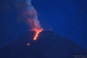
Italy , Stromboli :
WEEKLY BULLETIN, from March 10, 2025 to March 16, 2025 (issue date March 18, 2025)
ACTIVITY STATUS SUMMARY
Based on monitoring data, the following is highlighted:
1) VOLCANOLOGICAL OBSERVATIONS: During this period, ordinary eruptive activity was observed. The total hourly frequency ranged between average values (5-13 events/h). The intensity of the explosions was low and medium in the North and South-Central crater areas.
2) SEISMOLOGY: The monitored seismic parameters do not show any significant variations.
3) GROUND DEFORMATION: Ground deformation monitoring networks did not show any significant variations over the past week. 4) GEOCHEMISTRY: SO2 flux at an average level
The soil CO2 flux in the Pizzo area (STR02) remains at very high values.
CO2/SO2 ratio in the plume (Stromboli Plume Network) No updates, the latest data (17/03) show very high values.
Dissolved helium isotope ratio (R/Ra) in the thermal aquifer: The data from March 4, 2025, show high values.
Soil CO2 flux in the San Bartolo area is at low values.
Soil CO2 flux in the Scari area is at average values.
5) SATELLITE OBSERVATIONS: The thermal activity observed by satellite in the summit area was generally low.
VOLCANOLOGICAL OBSERVATIONS
During the observation period, Stromboli’s eruptive activity was characterized by analyzing images recorded by INGV-OE surveillance cameras located at an altitude of 190 m (SCT-SCV) and at Punta dei Corvi (SPCT). Explosive activity was produced mainly by four eruptive vents located in the northern area of the crater and two vents located in the central-southern area.
Observations of explosive activity captured by surveillance cameras
In the northern (N) crater area, four active vents were observed, producing low-intensity explosive activity (less than 80 m in height) and sometimes medium-intensity explosive activity (less than 150 m in height). The ejected products consisted mainly of coarse materials (bombs and lapilli). The average explosion frequency ranged from 4 to 9 events/h. In the South-Central (SC) area, explosive activity was produced by at least two vents. The explosions were of low and medium intensity, emitting fine materials (ash) sometimes mixed with coarse materials (lapilli and bombs). The average explosion frequency ranged from 1 to 4 events/h.
Source : INGV
Photo : Stromboli stati d’animo / Sebastiano Cannavo.
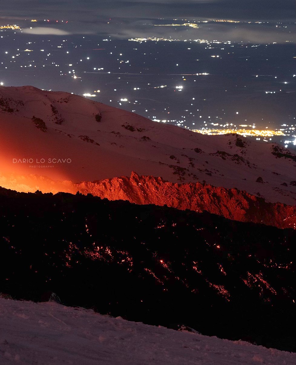
Iceland , Reykjanes Peninsula :
No sign of subsidence around Svartsengi
Eruption at the Sundhnúkur crater row remains likely
Updated 18 March at 13:00 UTC
Magma continues to accumulate, and its volume beneath Svartsengi has never been greater since the eruption sequence began in December 2023
The most likely scenario is that this magma accumulation phase will end with a magma intrusion and an eruption, initially occurring in the area between Sundhnúkur and Stóra-Skógfell
Seismic activity has been gradually increasing over the past few weeks, indicating that pressure at the eruption site is rising
An eruption could begin with very little warning
The hazard assessment remains unchanged and is valid until March 25
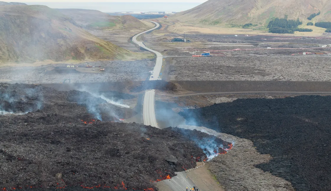
There has been a clear increase in seismic activity near the Sundhnúkur crater row on a weekly basis, except for the last week of February, which was likely due to weather conditions. The seismic station that previously caused measurement disturbances has been corrected. Earthquake activity continues in the same location as in the lead-up to previous eruptions—between Sundhnúkur and Stóra-Skógfell—where magma first reached the surface in six of the seven eruptions since December 2023.

The image shows earthquake activity around the Sundhnúkur crater row from the last eruption on December 8, 2024, until today, March 18. The map displays the location of earthquakes during this period. Note that the positioning of earthquakes east of the Sundhnúkur crater row still needs to be corrected. The lava field from the last eruption is shown in gray, while dark red lines indicate the location of eruption fissures from eruptions since December 2023. The upper graph shows earthquake magnitudes over time, while the lower graph illustrates the weekly earthquake count, which has been increasing recently.
Deformation measurements indicate continued uplift
Deformation measurements (GPS measurements) indicate that uplift continues, although at a slightly reduced rate. There are no signs of subsidence in the area around Svartsengi, according to GPS data and InSAR observations. Magma continues to accumulate beneath Svartsengi, and its volume has never been greater since the eruption sequence at the Sundhnúkur crater row began in December 2023.
Source : IMO
Photo : RÚV – Ragnar Visage (06 /2024)
Colombia , Puracé – Los Coconucos volcanic chain :
Popayán, March 18, 2025, 3:30 p.m.
According to monitoring of the activity of the Puracé Volcano – Los Coconucos Volcanic Chain, the Colombian Geological Survey (SGC), an entity affiliated with the Ministry of Mines and Energy, reports that:
During the week of March 11-17, seismic activity associated with rock fracturing was mainly located beneath the Puracé volcanic edifice, at depths ranging from 1 to 3 km, with a maximum recorded magnitude of 0.9. Fluid dynamic events were located at depths less than 2 km, particularly beneath the crater of the Puracé Volcano. Furthermore, seismic signals were recorded associated with the remobilization of ash deposited in the upper part of the volcanic chain on January 20. This caused an increase in flow, turbidity, and a change in water color in the Cocuy and Rio Blanco streams, which originate on the north and south flanks of the chain, due to the heavy rains that occurred in this area.
Moderate sulfur dioxide (SO2) emissions were recorded using field and satellite instruments. The slow deformation process is maintained between the volcanic structures of Puracé, Piocollo, and Curiquinga.
Images captured by visible and infrared webcams showed degassing processes in the lateral fumarole and inside the crater of the Puracé volcano.
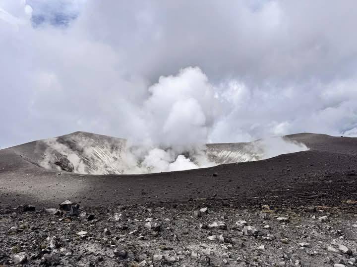
It is concluded that degassing continues in the lateral fumarole and in the crater of Puracé Volcano, accompanied by seismic activity beneath the volcano itself, slow deformation changes, surface thermal anomalies, and the appearance of secondary flows associated with the remobilization of materials deposited in the upper part of the volcanic chain.
Under Yellow alert status, phenomena such as sporadic ash emissions (minor eruptions of limited magnitude and effects, whose dispersion depends on wind direction), the presence of incandescence, small explosions in the crater, low-energy thermal anomalies, noise, felt earthquakes, odors, precipitation of elemental sulfur near the crater and in hot springs and fumaroles, as well as degassing in areas other than the crater, may occur. Fissure formation and minor lahars, among other things, are also being observed.
Based on the above, the SGC recommends closely monitoring the evolution of volcanic activity through weekly bulletins and other information published on official channels, as well as heeding the instructions of local and departmental authorities and the National Disaster Risk Management Unit (UNGRD).
The alert status for volcanic activity remains at yellow alert: active volcano with changes in the behavior of the baseline of monitored parameters and other manifestations.
Source : SGC
Photo : Carlos Carillo via Wulkany swiati / FB
Indonesia , Ili Lewotolok :
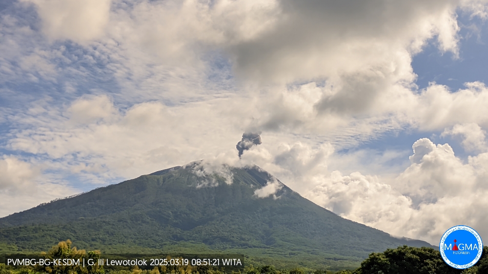
An eruption of Mount Ili Lewotolok occurred on Wednesday, March 19, 2025, at 08:50 WITA with an observed ash column height of ± 700 m above the peak (± 2123 m above sea level). The ash column was observed to be gray to black in color with a thick intensity, oriented toward the east. This eruption was recorded on a seismograph with a maximum amplitude of 21.9 mm and a duration of 29 seconds.
Seismicity Observations:
49 eruption earthquakes with an amplitude of 6.2 to 34.6 mm and a duration of 32 to 62 seconds.
81 emission earthquakes with an amplitude of 1.1 to 14.9 mm and a duration of 18 to 56 seconds.
42 deep volcanic earthquakes with an amplitude of 1.2 to 22.2 mm and a duration of 6 to 20 seconds.
1 earthquake was felt, MMI scale II with an amplitude of 38.9 mm, and the earthquake lasted 251 seconds.
4 distant tectonic earthquakes with an amplitude of 1.2 to 11.7 mm and an earthquake duration of 47 to 251 seconds.
Recommendation
At Activity Level II (Alert), it is recommended:
(1) The community around Mount Ili Lewotolok and visitors/climbers/tourists should not enter or conduct activities within a 2 km radius of the Mount Ili Lewotolok activity center, and the community of Lamatokan Village and Jontona Village should always be aware of the potential threat of lahars/landslides originating from the eastern part of the peak/crater of Mount Ili Lewotolok. (2) The community around Mount Ili Lewotolok, as well as visitors/climbers/tourists and the community of Jontona Village and Todanara Village shall not enter and carry out activities in the South and South-East sectoral areas within 2.5 km around the activity center of Mount Ili Lewotolok, and shall be aware of the potential threat of avalanche/landslide/lahar danger from the South and South-East parts of the peak/crater of Mount Ili Lewotolok.
Source et photo : Magma Indonésie .