March 12 , 2025 .
Hawaii , Kilauea :
HAWAIIAN VOLCANO OBSERVATORY STATUS REPORT , U.S. Geological Survey
Tuesday, March 11, 2025, 3:35 AM HST (Tuesday, March 11, 2025, 13:35 UTC)
19°25’16 » N 155°17’13 » W,
Summit Elevation 4091 ft (1247 m)
Current Volcano Alert Level: WATCH
Current Aviation Color Code: ORANGE
Activity Summary:
Episode 13 of the ongoing Halemaʻumaʻu eruption began at 2:36 a.m. HST on March 10. Fountains reached heights of 400-500 feet (120-150 m) by 3:30 a.m.
Episode 13 was preceded by small, sporadic spatter fountains 15-30 feet high (5-10 m) that began at approximately 1:30 p.m. HST on March 10 within the north vent and continued to increase in intensity until 6:35 p.m. HST when spattering could be seen on the streaming webcam (V1). Spattering continued to increase during the night and into the early morning hours of March 11. Lava erupted from the north vent at 2:36 a.m. HST and high fountains began about 10 minutes later. Fountains from the north vent are now 400-500 feet (120-150 meters) by 3:30 a.m. HST. Lava flows from the north vent have covered 20-30% of Halemaʻumaʻu crater floor.
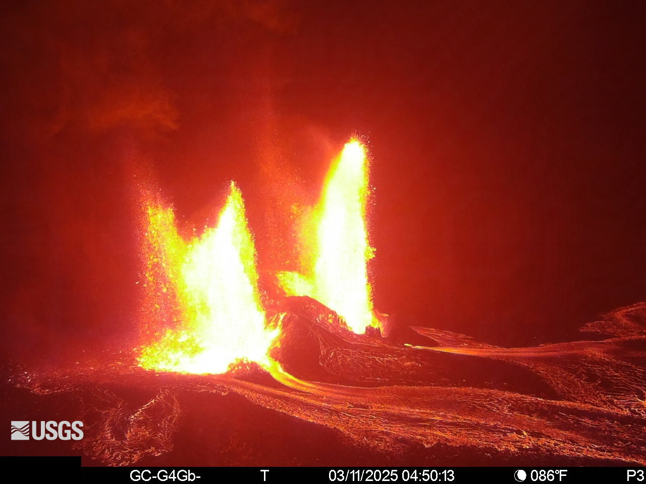
Inflationary tilt reached just over 11 microradians during the pause, recovering nearly all the deflationary loss during episode 12. Seismic tremor began increasing just before 2:30 a.m. HST when fountains within the north vent picked up and tilt at UWD switched from inflation to deflation at about 2:36 a.m. HST, about the same time lava flows began erupting onto the crater floor.
Each episode of Halemaʻumaʻu lava fountaining since December 23, 2024, has continued for 13 hours to 8 days and episodes have been separated by pauses in eruptive activity lasting less than 24 hours to 12 days.
No changes have been detected in the East Rift Zone or Southwest Rift Zone. HVO continues to closely monitor Kīlauea and will issue an eruption update tomorrow morning unless there are significant changes before then.
Kīlauea Volcano Alert Level/Aviation Color Code remain at WATCH/ORANGE. All current and recent activity is within Hawaiʻi Volcanoes National Park.
Tuesday, March 11, 2025, 3:42 PM HST (Wednesday, March 12, 2025, 01:42 UTC)
Activity Summary:
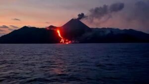
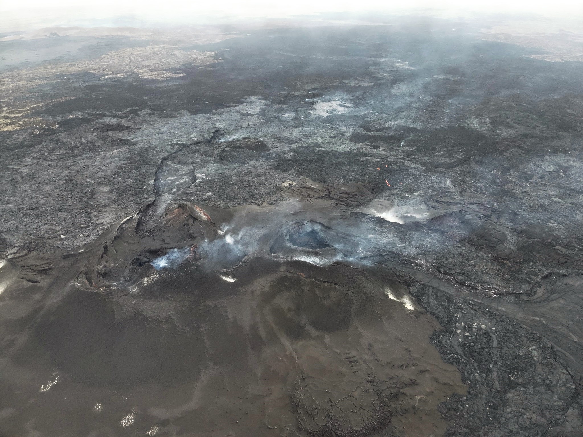
Episode 13 of the ongoing Halemaʻumaʻu eruption ended at 3:13 p.m. HST on March 11. The north vent ceased fountaining abruptly at 3:11 p.m. HST. Subsequently, the south fountain became unsteady and also ceased activity by 3:13 p.m. HST. Episode 13 fountaining lasted for 12 hours and 37 minutes, and lava flows have covered more than 60% of Halemaʻumaʻu crater floor.
Deflationary tilt reached 13 microradians lost during episode 13 before resuming inflationary tilt at 3:13 p.m. HST after fountaining ceased.

On March 11, HVO geologists observed episode 13 of the ongoing Kīlauea summit eruption from the western caldera rim. Lava fountains from the north vent (left) and south vent (right) were feeding channelized flows across the floor of Halema‘uma‘u crater.
Measurements of SO2 emission rates were approximately 40,000 tonnes per day this morning during high fountaining. Peleʻs hair was reported falling this morning in the town of Pahala about 25 miles (40 kilometers) downwind to the southwest of Halemaʻumaʻu. Each episode of Halemaʻumaʻu lava fountaining since December 23, 2024, has continued for 13 hours to 8 days and episodes have been separated by pauses in eruptive activity lasting less than 24 hours to 12 days.
No changes have been detected in the East Rift Zone or Southwest Rift Zone. HVO continues to closely monitor Kīlauea and will issue an eruption update tomorrow morning unless there are significant changes before then.
Kīlauea Volcano Alert Level/Aviation Color Code remain at ATTENTION/ORANGE. All current and recent activity is within Hawaiʻi Volcanoes National Park.
Source : HVO
Photos : USGS , USGS/ M. Patrick.
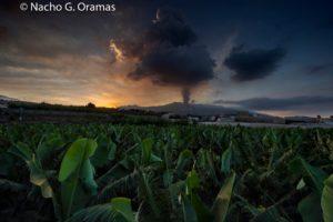
Iceland , Reykjanes Peninsula :
Expectation of a New Eruption in the Sundhnúkur Crater Row is Ongoing . Updated 11 March at 16:20 UTC .
Magma accumulation continues at a similar rate.
The volume of magma beneath Svartsengi is at its highest level since the series of eruptions began in December 2023.
Seismic activity has increased in recent days.
The most probable outcome is that this period of magma accumulation will culminate in a dike intrusion and eruption.
An eruption could begin with very little warning.
The hazard assessment remains unchanged and is valid until March 18.
Deformation measurements show that land uplift continues at the same rate as in recent weeks. Magma continues to accumulate beneath Svartsengi, and its volume has reached the highest level recorded since the eruptive series began at the Sundhnúkur crater row in December 2023.
Seismic activity in the Sundhnúkur crater row has been gradually increasing alongside magma accumulation, following a pattern similar to that observed before the November eruption.
Since the last eruption ended, seismic activity has been located slightly further east compared to the activity leading up to the eruption that began on November 20, 2024. The earthquakes east of the Sundhnúkur crater row are likely tectonic earthquakes caused by increased pressure in the region due to magma accumulation. Therefore, these earthquakes are not necessarily an indication of the likely eruption site, although this cannot be ruled out. Further analysis of the seismic data is currently underway and may shed more light on the cause of this shift in the earthquake location.
Considering the increasing seismic activity alongside continued land uplift and magma accumulation, the most likely scenario is that this period of magma accumulation will result in a dike intrusion towards the Sundhnúkur crater row. It is likely that this will result in a volcanic eruption, marking the eighth eruption since the end of 2023.

Image displaying seismic activity around the Sundhnúkur crater row from September 8, 2024, to today, March 11, 2025. The data therefore includes seismic activity between the eruption that ended on September 8 and the one that began on November 20, as well as the period from the end of the last eruption to today. Green circles on the map indicate the location of earthquakes before the eruption that began on November 20, 2024, while red circles represent earthquakes in recent weeks. The extent of the lava field created in the last eruption is depicted by the gray overlay, and dark red lines indicate the location of eruptive fissures that opened during the eruptions that occurred in the area since December 2023.
The next eruption could be larger than previous ones
Three months have passed since the most recent eruption concluded, lasting 18 days and ending on December 8. This is the longest period of magma accumulation that has been observed during this eruptive series on the Sundhnúkur crater row, with today marking 111 days since the last eruption began on November 20, 2024.
The volume of magma that has accumulated beneath Svartsengi during this period is the highest estimated since the beginning of this eruptive series in December 2023. Therefore, it is possible that, if an eruption occurs in the coming days or weeks, it could be comparable to or larger than the eruption in August 2024, which was the largest so far in terms of volume. Based on past events, the size of the possible eruption will depend on how much magma is released from the magma chamber when the eruption begins. Currently, it is difficult to predict the size of the next event with certainty.
Source : IMO
Photo : Ljósmynd: Almannavarnir/Björn Oddsson ,
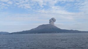
Italy / Sicile , Etna :
WEEKLY BULLETIN, from March 3, 2025 to March 9, 2025. (Issue date March 3, 2025)
ACTIVITY STATUS SUMMARY
Based on monitoring data, the following is highlighted:
1) VOLCANOLOGICAL OBSERVATIONS: Variable rate degassing activity from summit craters.
2) SEISMOLOGICAL: Low seismic activity due to fracturing; medium amplitude of volcanic tremor at mid-level.
3) INFRASOUND: Low infrasound activity.
4) GROUND DEFORMATION: Over the past week, ground deformation monitoring networks have not recorded any significant changes. 5) GEOCHEMISTRY: SO2 flux decreasing toward an average level
Soil CO2 flux (Etna Gas Network) increasing while remaining within average values.
The partial pressure of dissolved CO2 in the aquifer (Ponteferro) shows values within seasonal variability.
Isotope ratio of peripheral sites: Latest data (19/02/2025) on medium-high values.
6) SATELLITE OBSERVATIONS: Thermal activity observed by satellite in the summit area was generally low, with some isolated moderate thermal anomalies.
7) OTHER OBSERVATIONS: The morphostructural analysis of the summit area was made possible thanks to data obtained from numerous drone surveys. In summary, craters BN1 and 2 have reformed, numerous fractures and a pit crater on the southern flank of the Bocca Nuova have been observed and quantified.
VOLCANOLOGICAL OBSERVATIONS
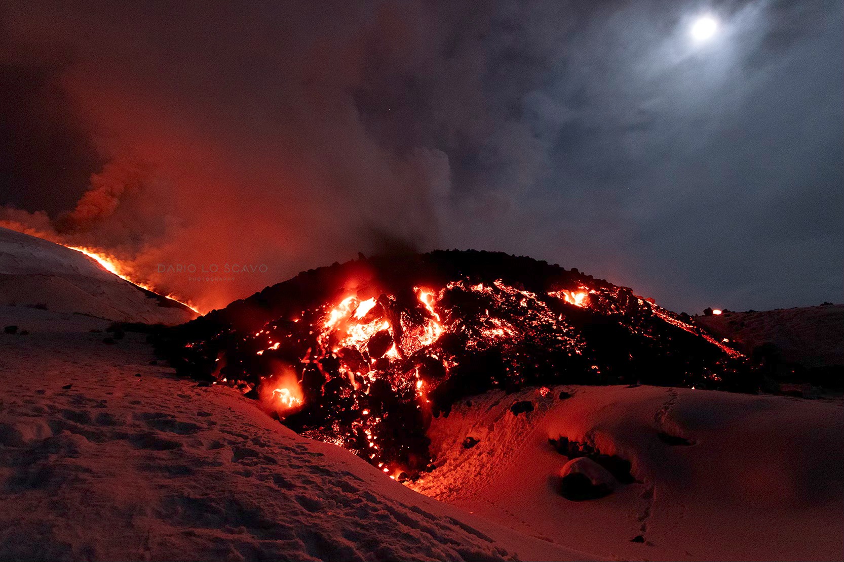
During the month in question, monitoring of Mount Etna’s volcanic activity was carried out through the analysis of images from the INGV-Etneo Observatory’s surveillance cameras and through an inspection carried out on March 6 in the summit area. Following the end of lava emission from the eruptive fissure, which opened at an altitude of 3,050 m, on March 2,
from March 3 onwards, observation of the summit area and craters was partially discontinuous due to cloud cover. Overall, during periods of visibility, it was observed that Etna’s activity was characterized by continuous degassing of varying intensity and regime in individual craters.
In particular, the Voragine and Bocca Nuova craters exhibit intense degassing, primarily affecting the western sector of Bocca Nuova. The southeast crater is affected by impulsive degassing, while the northeast crater is characterized by degassing generated by a vent located on the floor.
Source : INGV
Photo : Dario Lo Scavo .
Italy , Stromboli :
WEEKLY BULLETIN, from March 3, 2025 to March 9, 2025. (Issue date March 3, 2025)
ACTIVITY STATUS SUMMARY
Based on monitoring data, the following is highlighted:
1) VOLCANOLOGICAL OBSERVATIONS: During this period, ordinary eruptive activity was observed. The total hourly frequency ranged from average values (5-13 events/h). The intensity of the explosions was low to average in the North and South-Central crater areas.
2) SEISMOLOGICAL: The monitored seismic parameters do not show any significant variations.
3) GROUND DEFORMATION: Ground deformation monitoring networks did not show any significant variations over the past week. 4) GEOCHEMISTRY: SO2 flux at an average level
The soil CO2 flux in the Pizzo area (STR02) remains at very high values.
CO2/SO2 ratio in the plume (Stromboli Plume Network) No update, the latest data (28/02) show very high values.
Dissolved helium isotope ratio (R/Ra) in the thermal aquifer: The data from March 4, 2025, show high values.
Soil CO2 flux in the San Bartolo area is at low values.
Soil CO2 flux in the Scari area is at average values.
5) SATELLITE OBSERVATIONS: The thermal activity observed by satellite in the summit area was generally low.
VOLCANOLOGICAL OBSERVATIONS
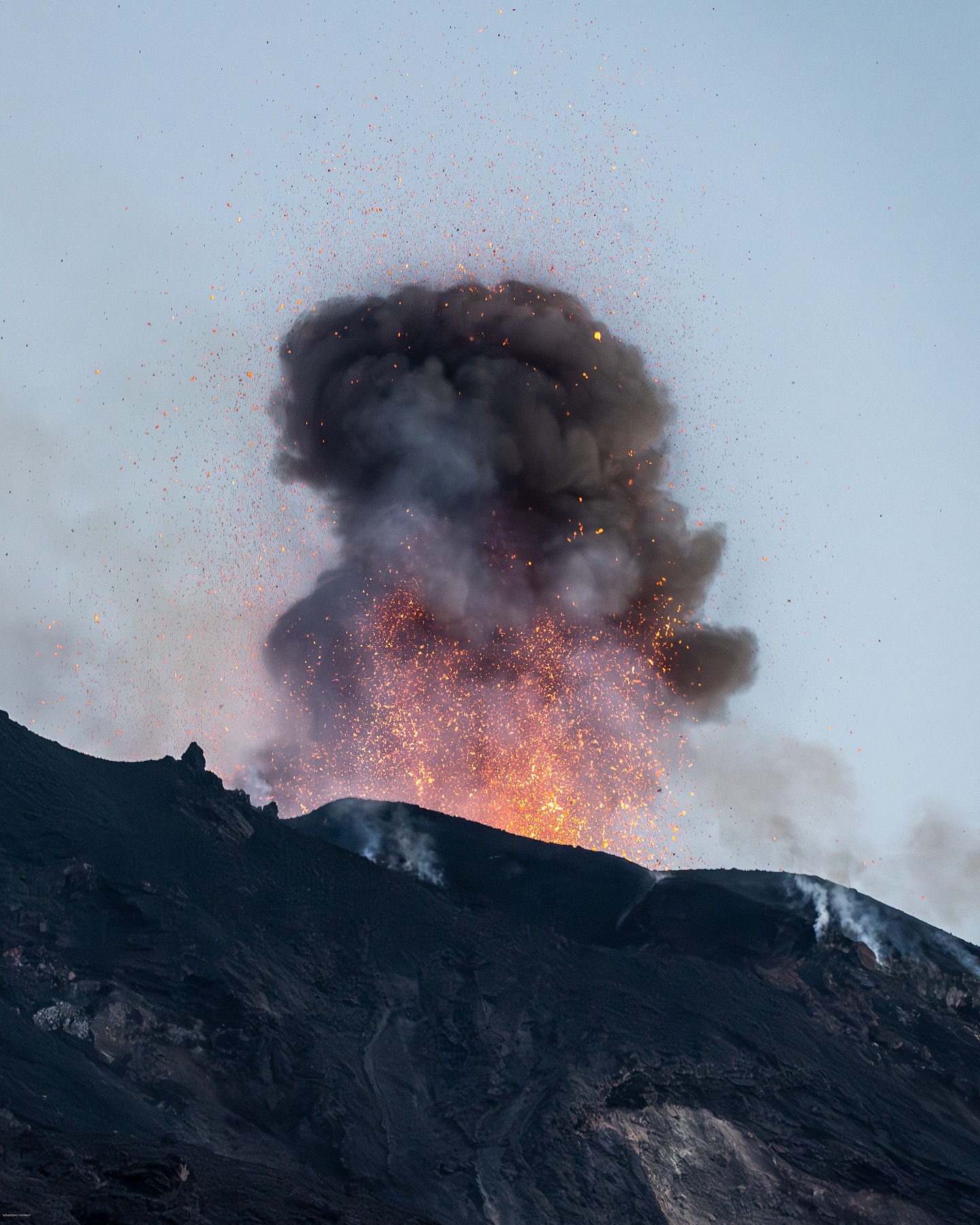
During the observation period, Stromboli’s eruptive activity was observed through the analysis of images recorded by INGV-OE surveillance cameras located at an altitude of 190 m (SCT-SCV) and at Punta dei Corvi (SPCT). The explosive activity was produced mainly by four eruptive vents located in the northern area of the crater and by two vents located in the central-southern area.
Due to adverse weather conditions, visibility of the crater terrace on March 7 was insufficient for an accurate description of the eruptive activity.
Observations of explosive activity captured by surveillance cameras
In the northern crater area, four active vents were observed, producing explosive activity of low intensity (less than 80 m in height) and sometimes of medium intensity (less than 150 m in height). The emitted products were mainly coarse materials (bombs and lapilli). The average explosion frequency ranged from 3 to 9 events/h.
In the South-Central (SC) zone, explosive activity was produced by at least two vents. The explosions were of low and medium intensity, emitting fine materials (ash) sometimes mixed with coarse materials (lapilli and bombs). The average explosion frequency ranged from 2 to 6 events/h.
Source : INGV
Photo : Stromboli stati d’animo / Sebastiano Cannavo
Guatemala , Fuego :
Weather conditions: Clear.
Wind: Southwest.
Precipitation: 0.0 mm.
Activity:
The effusive eruption of Fuego Volcano continues, producing an incandescent fountain 500 meters above the crater, as well as dense columns of gas and ash reaching 6,000 meters above sea level (19,685 feet). The ash is dispersed northwest and west, covering distances of between 100 and 120 km. Furthermore, due to recent pyroclastic flows generated in the volcano’s various ravines, ash is present at low altitudes, remobilized by the southwest wind.
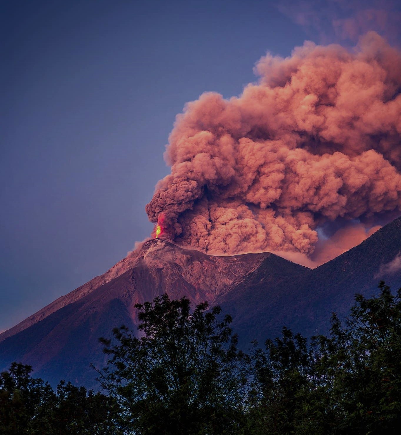
This eruptive activity could persist in the coming hours or days, which does not exclude the possibility of new pyroclastic flows, particularly towards the Seca ravine, as well as the continuation of fine ashfall on the surrounding communities. The explosions generate rumbling sounds and shock waves. It is recommended to follow the instructions in special bulletin BEFGO-006-2025 and to stay tuned for special bulletins and ash dispersal maps issued by INSIVUMEH.
Source : Insivumeh
Photo : David Rojas.