March 10 , 2025.
Indonesia , Dukono :
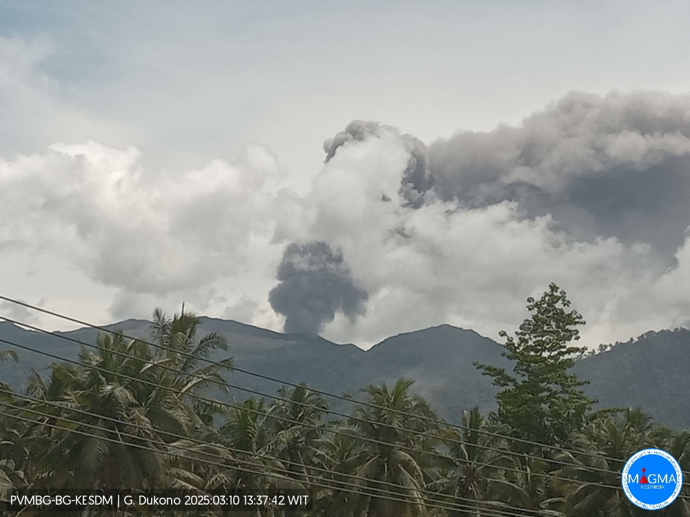
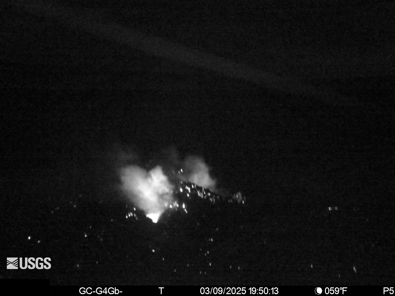
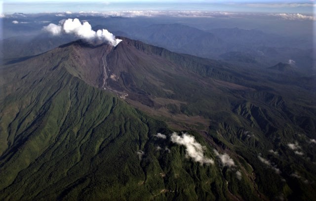
An eruption of Mount Dukono occurred on Sunday, 9 March 2025 at 14:18 WIT with an observed ash column height of ±2000 m above the peak (±3087 m above sea level). The ash column was observed to be grey to black in colour with a thick intensity, oriented towards the northwest. At the time of writing, the eruption was still ongoing.
VOLCANO OBSERVATORY NOTICE FOR AVIATION – VONA
Issued : March 09 , 2025
Volcano : Dukono (268010)
Current Aviation Colour Code : ORANGE
Previous Aviation Colour Code : orange
Source : Dukono Volcano Observatory
Notice Number : 2025DUK024
Volcano Location : N 01 deg 41 min 35 sec E 127 deg 53 min 38 sec
Area : North Maluku, Indonesia
Summit Elevation : 3478 FT (1087 M)
Volcanic Activity Summary :
Eruption with volcanic ash cloud at 05h18 UTC (14h18 local).
Volcanic Cloud Height :
Best estimate of ash-cloud top is around 9878 FT (3087 M) above sea level or 6400 FT (2000 M) above summit. May be higher than what can be observed clearly. Source of height data: ground observer.
Other Volcanic Cloud Information :
Ash cloud moving to northwest. Volcanic ash is observed to be gray. The intensity of volcanic ash is observed to be thick.
Remarks :
Eruption and ash emission is continuing. Eruption recorded on seismogram with maximum amplitude 34 mm.
Source et photo : Magma Indonésie .
Hawaii , Kilauea :
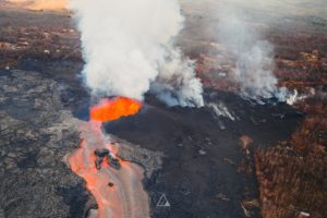
Both the north and south vents continued to glow last night, with a noticeable increase on the V1 camera in the early morning hours. Glow from the north vent illuminated the back wall of the cone, indicating magma continues to rise in the conduit. Lava flows unrelated to the episode 12 eruption continue to slowly spread out on the down-dropped block on the eastern side of Halemaʻumaʻu. These are fed from by older stored lava from beneath the crater floor.
Summit tilt continues in an inflationary direction and has recovered nearly 9 microradians (at Uēkahuna bluff) as of March 9, since the end of episode 12. Three earthquakes were located within Kīlauea’s summit region yesterday, all below magnitude-2.0. Volcanic tremor decreased significantly with the end of episode 12. Rates of SO2 emissions have dropped since the end of the episode and were measured at 1,000 tonnes/day on Friday, which is in the typical range for eruption pauses.
Episodes of Halemaʻumaʻu lava fountaining since December 23, 2024, have continued for 13 hours to 8 days and episodes have been separated by pauses in eruptive activity lasting from less than 24 hours to 12 days. While episode 12 began with intermittent eruption at 7:30 a.m. HST, continuous eruption did not begin until 12:45 p.m. HST and lasted for just under 22 hours.
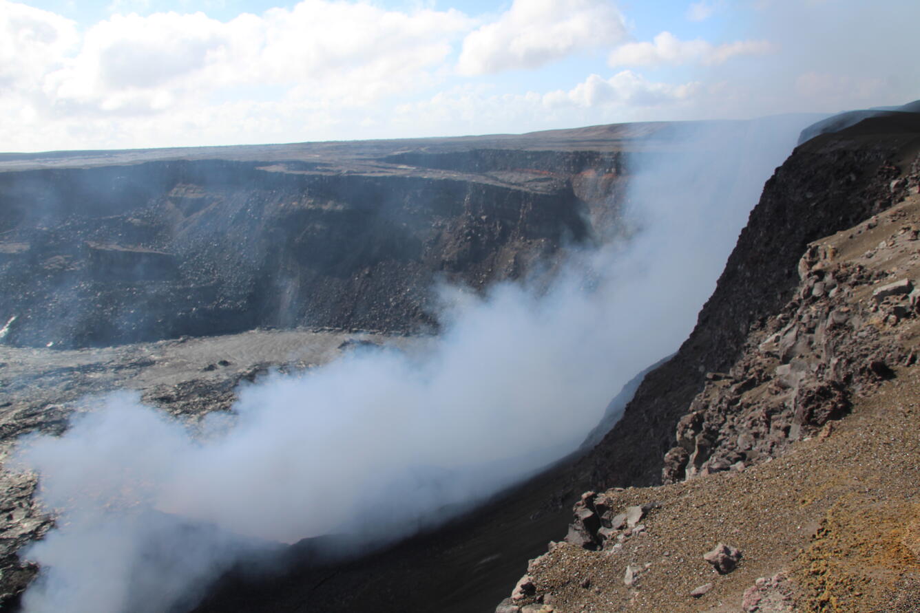
A day after the end of episode 12 of the ongoing eruption at Kīlauea’s summit, volcanic gas emissions continue from the recently active north and south cones on the western edge of Halema‘uma‘u. Most of the gas consists of water vapor (the primary volcanic gas), with sulfur dioxide (SO2) and other gases. Sulfur dioxide emissions are causing vog downwind of the summit area. When this photo was taken the morning of March 6, the emission rate was approximately 1,200 tons of SO2 per day, similar to other periods between eruptive episodes in the ongoing eruption.
Strands of volcanic glass known as Pele’s Hair have been reported on surfaces throughout the summit area of Hawai’i Volcanoes National Park and surrounding communities.
Source : HVO
Photos : USGS / N. Deligne.
Chile , Laguna del Maule :
Seismology
The seismological activity of the period was characterized by the recording of:
1728 VT-type seismic events, associated with rock fracturing (Volcano-Tectonic). The most energetic earthquake had a local magnitude (ML) value equal to 2.3, located 7.9 km to the southwest and with a depth of 6.8 km from the center of the lagoon.
2 LP-type seismic events, associated with fluid dynamics within the volcanic system (Long Period). The size of the largest earthquake estimated using the reduced displacement parameter (DR) was less than 1 cm2.
2 TR-type seismic events, associated with sustained fluid dynamics within the volcanic system (TRemor). The size of the largest earthquake estimated from the reduced displacement parameter (DR) was equal to 4 cm2.
70 HB-type seismic events, associated with both rock fracturing and fluid dynamics within the volcanic system (hybrid). The most energetic earthquake had a local magnitude (ML) of 2.9, located 13.7 km to the South-Southeast and with a depth of 7.3 km from the center of the lagoon.
Fluid Geochemistry
No anomalies in sulfur dioxide (SO2) emissions into the atmosphere were reported in the area near the volcanic complex, according to data published by the Tropospheric Monitoring Instrument (TROPOMI) and the Ozone Monitoring Instrument (OMI) Sulfur Dioxide Group.
Satellite Thermal Anomalies
During the period, no thermal alerts were recorded in the area associated with the volcanic complex, according to the analytical processing of Sentinel 2-L2A satellite images, in combination with false-color bands.
Geodesy
The geodetic activity of the period was characterized by:
– Medium to high horizontal deformation rates with maximums reaching 0.8 cm/month.
– High vertical deformation rates reaching a maximum of 1.99 cm/month at the station located southwest of the lagoon.
– From InSar, the same deformation pattern can be observed, showing inflation with maximum deformation close to the MAU2 station of the GNSS network.
The above indicates that the historically recorded inflationary process continues at rates similar to those reported in previous periods.
Surveillance cameras
The images provided by the fixed camera, installed near the volcanic complex, did not record degassing columns or variations related to surface activity.
Satellite geomorphological analysis
No morphological variations associated with volcanic activity are identified from the Planet Scope and Sentinel 2 L2A satellite images.
The activity has remained at levels considered low, suggesting stability in the volcanic complex. The technical volcanic alert remains in effect in:
GREEN TECHNICAL ALERT: Active volcano with stable behavior – No immediate risk
Observation:
The affected area is considered to be within a 2 km radius around the passive CO2 degassing zone.
Source : Sernageomin
Photo : OAVV
Costa Rica , Poas :
ERUPTION REPORT – OVSICORI-UNA
Location: N10.20 W84.23
Height of the Massif: 2687mts. (8813 feet)
Date: 03/09/2025 Time: 10:00
Height of the plume (above the crater): 656 feet ( 200 meters )
Source of observation of the plume: infrasound, webcam
Observed activity:
Two pulses of shock waves in the infrasound recording.
The steam plume rises several hundred meters.
The height of the column of solid material cannot be determined due to low visibility.
It is estimated that it does not exceed 200 m.
Preliminary increase in the amplitude of the tremor.
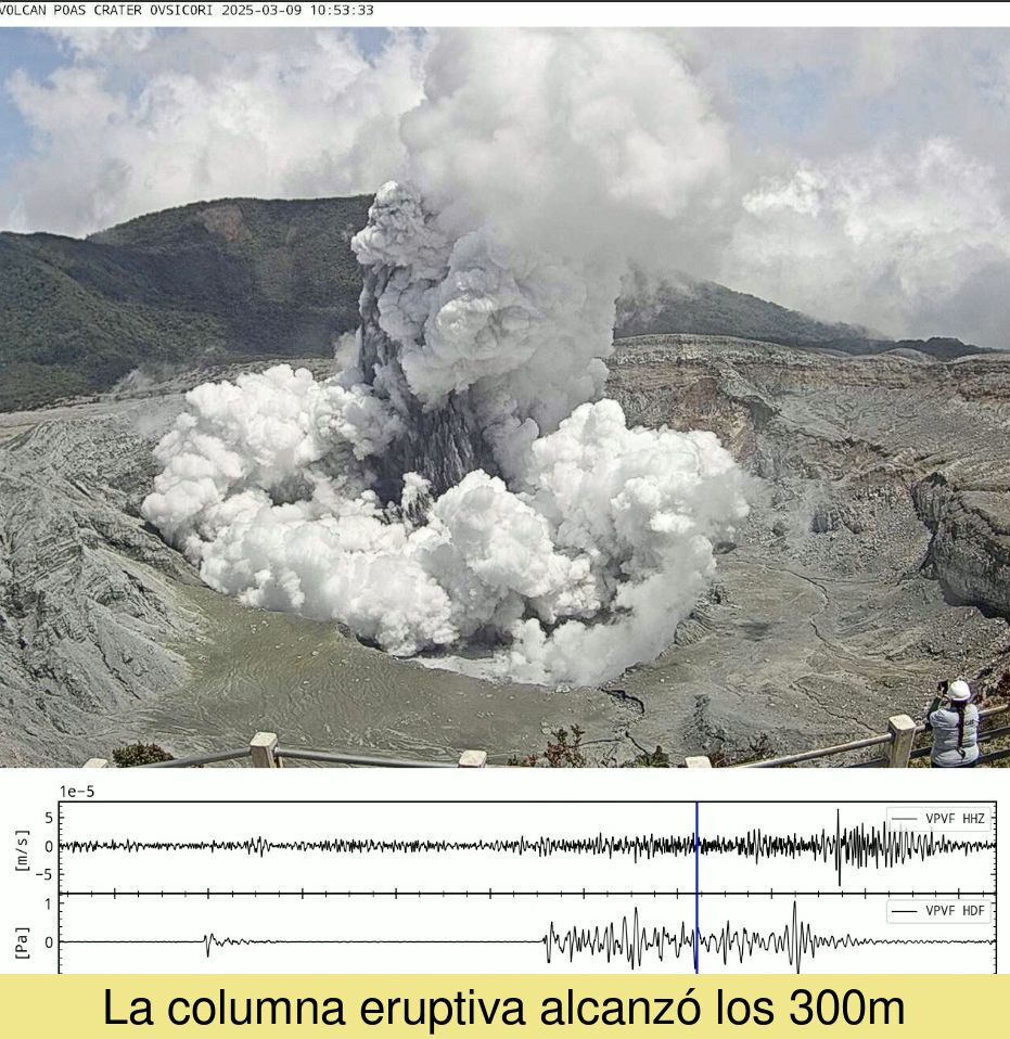
ERUPTION REPORT – OVSICORI-UNA
Date: 03/09/2025 Time: 10:53
Plume Height (above crater):
984 ft. (300 meters)
Plume Observation Source: Webcam, Seismic, Infrasound
Observed Activity:
A moderate phreatic eruption is recorded
Low frequency tremor continues
Activity Level: WARNING
Source et photo : Ovsicori .
Ecuador , El Reventador .
DAILY REPORT ON THE STATE OF THE REVENTADOR VOLCANO , Sunday, March 09, 2025.
Information Geophysical Institute – EPN.
Surface Activity Level: High , Surface Trend: No changes
Internal Activity Level: Moderate , Internal Trend: No changes
From March 08, 2025, 11:00h to March 09, 2025, 11:00h:
Seismicity:
Below is the count of seismic events recorded at the reference station.
Explosion (EXP) 73
Long Period (LP) 16
Emission Tremor (TREMI) 6
Harmonic Tremor (TRARM) 5
Rainfall/Lahars:
No rain has been recorded in the volcano area. **Heavy rains could remobilize accumulated material, generating mud and debris flows that would flow down the sides of the volcano and into adjacent rivers.**
Emission/Ash Column:
Thanks to the surveillance camera network, several emissions of gas and ash have been recorded at heights between 700 and 1000 meters above the crater level in the southwest and northwest directions. Associated with this activity, the Washington VAAC agency has published two reports of ash clouds at a height of 700 meters above the crater level in the southwest and southeast directions.
Observation:
During last night and early this morning, several episodes of incandescent material descending on the southeast flank of the volcano up to 800 meters below the crater level were recorded. At the time of closing this report, the volcano remains cloudy.
Alert Level – SGR: Orange
Source : IGEPN
Photo : Patricio Ramon, 2005 (Instituto Geofisca, Escuela Politecnica Nacional).