March 09 , 2025 .
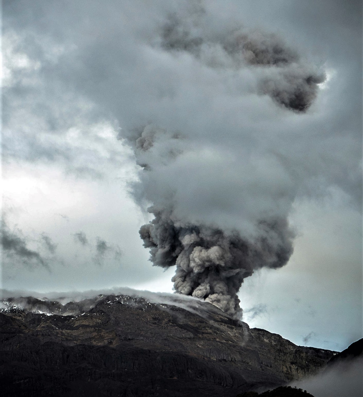
Indonesia , Semeru :
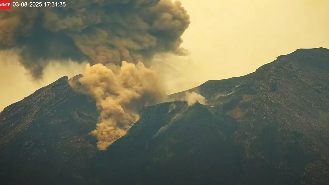
An eruption of Mount Semeru occurred on Sunday, March 9, 2025, at 07:26 WIB with an observed ash column height of ± 1300 m above the peak (± 4976 m above sea level). The observed ash column was white to gray in color with moderate intensity, oriented towards the South. At the time of writing, the eruption was still ongoing.
VOLCANO OBSERVATORY NOTICE FOR AVIATION – VONA
Issued : March 09 , 2025
Volcano : Semeru (263300)
Current Aviation Colour Code : ORANGE
Previous Aviation Colour Code : orange
Source : Semeru Volcano Observatory
Notice Number : 2025SMR1162
Volcano Location : S 08 deg 06 min 29 sec E 112 deg 55 min 12 sec
Area : East java, Indonesia
Summit Elevation : 11763 FT (3676 M)
Volcanic Activity Summary :
Eruption with volcanic ash cloud at 00h26 UTC (07h26 local).
Volcanic Cloud Height :
Best estimate of ash-cloud top is around 15923 FT (4976 M) above sea level or 4160 FT (1300 M) above summit. May be higher than what can be observed clearly. Source of height data: ground observer.
Other Volcanic Cloud Information :
Ash cloud moving to south. Volcanic ash is observed to be white to gray. The intensity of volcanic ash is observed to be medium.
Remarks :
Eruption recorded on seismogram with maximum amplitude 22 mm and maximum duration 126 second.
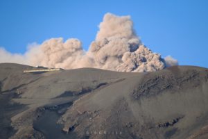
Source : Magma Indonésie.
Photo : afar tv , Capture d’écran 08 Mars 2025
Costa Rica , Poas :
OVSICORI-UNA press release, updated on March 7, 2025
Summary:
Monitoring observations suggest a new disturbance of the magma at depth.
This increases the probability of dangerous eruptions within the National Park (NP) (bombs, ash, gas, etc.) and impacts on populations (ash, gas) in the coming days and weeks.
Between March 1 and 2, an increase in the energy of phreatic eruptions was observed, as well as an increase in geophysical and geochemical signals. The eruption continues with frequent events.
In addition, as the lake disappears, ash emissions are expected, as well as a potential explosive transition with the ejection of volcanic bombs. The activity level of the volcano has therefore been raised from WARNING to CAUTION (level 3 on a scale of 4).
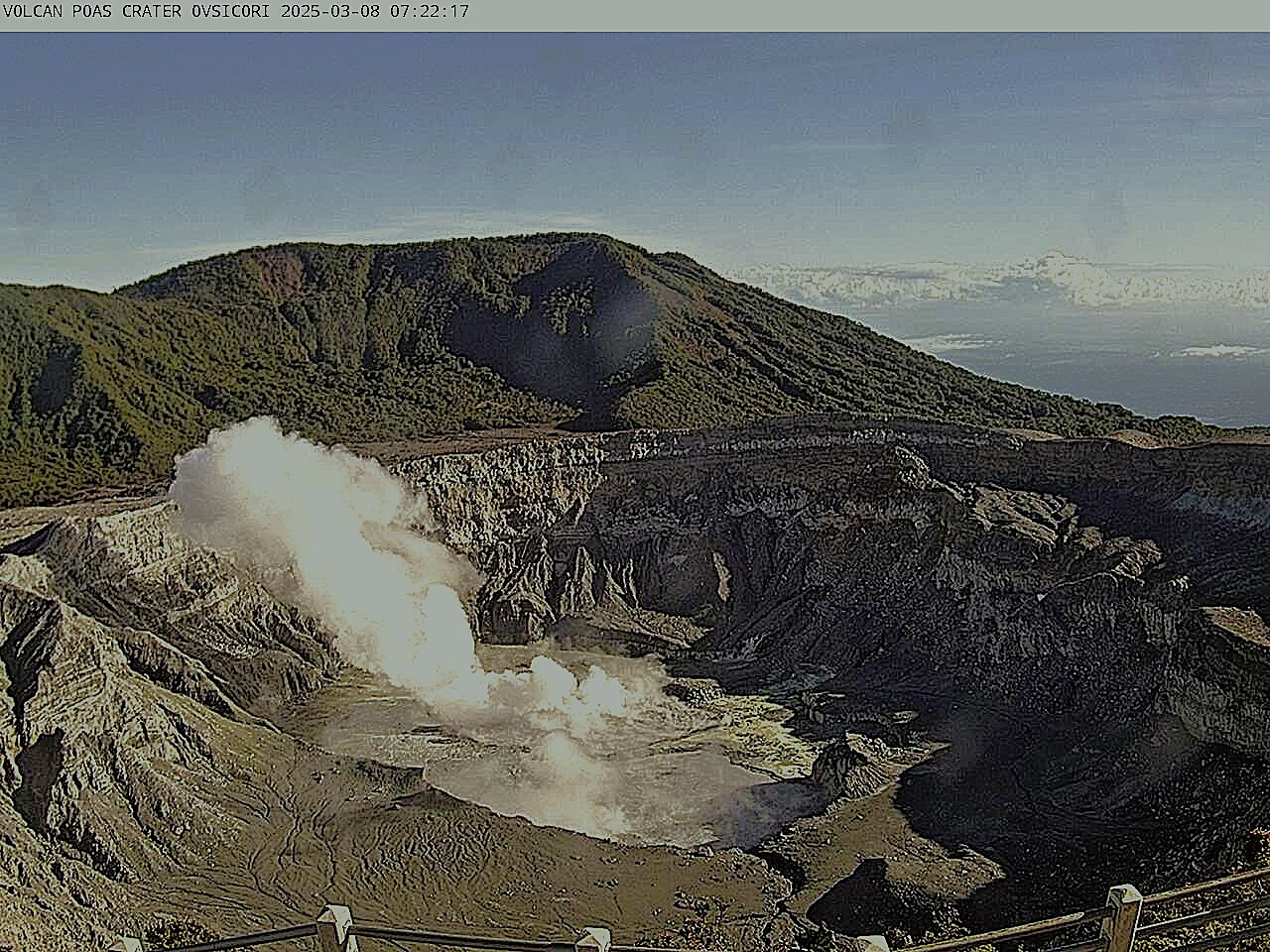
Seismic and acoustic activity
Two long-period (LP) events larger than those usually recorded on the Poás were recorded during the 18 hours preceding the eruption on March 1. Since the increase in eruptive activity on March 1, an increase in distal and proximal volcano-tectonic activity has been recorded. A maximum of 7 distal earthquakes was reached on March 5. Most of the events occur on the southwest flank. The amplitude of the tremor fluctuated during the weekend when the eruptions occurred and stabilized at a moderate amplitude from the fourth day.
Source et photo : Ovsicori
Colombia , Nevado del Ruiz :
Manizales, March 4, 2025, 4:15 p.m .
Following the monitoring of the activity of the Nevado del Ruiz volcano, the Colombian Geological Survey (SGC), an entity attached to the Ministry of Mines and Energy, reports that:
During the week of February 25 to March 3, 2025, the volcano continued to show unstable behavior. Compared to the previous week, the main variations in the monitored parameters were:
– Seismic activity related to fluid dynamics inside long-period volcanic conduits, associated with continuous ash emission, as well as seismic signals related to pulsatile ash emissions decreased in the number of earthquakes and the seismic energy released. This seismicity presented low and sometimes moderate energy levels. Thanks to the cameras (conventional or thermographic) used to monitor the volcano and to the reports of the inhabitants of the surroundings of the volcano, some emissions of gas and ash have been confirmed. Changes in the apparent temperature of the emitted material have also been observed in several of the recorded emissions.
– The seismic activity associated with the processes of fracturing of the rocks inside the volcanic edifice has decreased in the number of earthquakes recorded and the seismic energy released.
The earthquakes were located mainly in the Arenas crater and on the northeast, north, southeast and southwest flanks of the volcano, at distances of up to 13 km from the crater and at depths between less than 1 km and 10 km measured from the volcanic summit. The largest earthquake of the week occurred on February 25 at 07:03 with a magnitude of 1.1 and was located 3 km east-northeast of the Arenas crater, at a depth of 3 km from the summit of the volcano.
– The emission of water vapour and gases, mainly sulphur dioxide (SO₂), into the atmosphere through the Arenas crater was variable. Daily SO₂ outgassing rates decreased slightly compared to the values estimated in previous weeks, due to both a decrease in the measured SO₂ concentration and meteorological conditions (e.g. wind direction) that did not favour data collection. Satellite monitoring, carried out in a complementary manner to assess this parameter, continues to show significant SO₂ releases into the atmosphere.
– The vertical height of the gas column remained at values mainly below 800 m measured at the summit of the volcano, with a maximum of 1100 m. In dispersion, the column reached 2000 m during the ash emission that occurred on 25 February at 02:37 in the morning. Regarding the direction of dispersion of the column, it showed a predominant trend towards the West-Southwest and West-Northwest of the volcano, with occasional variations towards the Northwest.
– When monitoring thermal anomalies at the bottom of the Arenas crater, using satellite monitoring platforms, some reports of low-energy anomalies were obtained. The detection of anomalies was affected by the high cloud conditions in the volcanic area.
Source : SGC
Photo : Álex Palacio
La Martinique , Mount Pelée :
Weekly report, Institut de physique du globe de Paris / Observatoire volcanologique et seismologique de Martinique
Saint-Pierre, March 7, 2025 at 3:15 p.m. local time (GMT-4)
Volcanic activity increased this week with 27 earthquakes of volcanic origin observed.
Between February 28, 2025 at 4:00 p.m. (UT) and March 7, 2025 at 4:00 p.m. (UT), the OVSM recorded 27 low-energy volcano-tectonic earthquakes. These earthquakes were clearly identified as originating from one of the well-known seismically active zones at Mount Pelée, located between 1.0 and 1.4 km deep below the summit of the volcano. The superficial seismicity of the volcano-tectonic type is associated with micro-fracturing in the volcanic edifice in connection with the global reactivation of the volcano observed since the end of 2018.
None of these earthquakes were felt by the population.

The previous week, the OVSM had recorded 12 earthquakes of volcanic origin. As of March 7, 2025 and over the past 4 weeks, the OVSM has therefore observed a total of 41 volcanic earthquakes, an average of 10 to 11 earthquakes per week.
During the volcanic reactivation phases of volcanoes similar to Mount Pelée, it is common to observe seismic activity that varies in intensity and frequency.
For more details on observations and interpretations of volcanic activity over the longer term, refer to the OVSM monthly bulletins.
The alert level is currently YELLOW: vigilance.
Source : Direction de l’OVSM-IPGP.
Photo : Parc naturel Martinique.
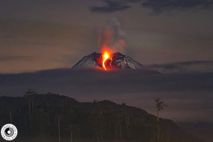
Ecuador , Sangay :
DAILY STATE REPORT OF SANGAY VOLCANO, Saturday, March 08, 2025.
Information Geophysical Institute – EPN.
Surface Activity Level: Moderate, Surface Trend: No Change
Internal Activity Level: Moderate, Internal Trend: No Change
Seismicity: From March 07, 2025, 11:00 a.m. to March 08, 2025, 11:00 a.m.:
Seismicity:
Below is the count of seismic events recorded at the reference station
Explosion (EXP): 141
Rainfall / Lahars:
Rainfall was recorded in the volcano area without generating mud and debris flows. **In case of heavy rains, it could remobilize the accumulated material, generating mud and debris flows that would descend on the sides of the volcano and flow into the adjacent rivers.
Emission / Ash Column:
Thanks to the network of surveillance cameras, an emission of gas and ash from a height of 300 meters above the level of the crater in the North-East directions was recorded. On the other hand, the W-VAAC agency has not issued reports associated with ash emissions in the last 24 hours.
Other monitoring parameters:
The MIROVA-VIIRS satellite system recorded 1 thermal anomaly, the MIROVAMODIS satellite system recorded 1 thermal anomaly and the FIRMS satellite system recorded 1 thermal anomaly in the last 24 hours.
Observation:
From yesterday afternoon until the closing of this report, the volcano remained cloudy most of the time.
Alert level: yellow
Source : IGEPN
Photo : Cámara Rota