March 03 , 2025
Hawaii , Kilauea :
Sunday, March 2, 2025, 10:26 AM HST (Sunday, March 2, 2025, 20:26 UTC)
19°25’16 » N 155°17’13 » W,
Summit Elevation 4091 ft (1247 m)
Current Volcano Alert Level: WATCH
Current Aviation Color Code: ORANGE
Activity Summary:
Kīlaueaʻs summit eruption paused as of at 7:06 a.m. HST on Wednesday, February 26 within Hawaiʻi Volcanoes National Park. A new episode is likely within the next 2-4 days.
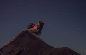
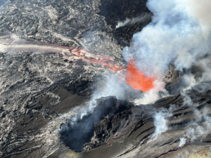
Episode 11 of the ongoing Halemaʻumaʻu eruption began at 6:26 p.m. HST on February 25 and fountains reached peak heights of around 600 feet (180 m) 1-2 hours later. The eruption ended on erupting after 12 hours and 40 minutes of activity. Kīlauea’s current eruption in Halemaʻumaʻu crater within Kaluapele (the summit caldera) began on December 23, 2024. There have been 11 episodes of lava fountaining separated by pauses in activity. All eruptive activity remains within Hawai’i Volcanoes National Park. No significant activity has been noted along Kīlauea’s East Rift Zone or Southwest Rift Zone.
Current hazards include volcanic gas emissions and windblown volcanic glass (Pele’s Hair) that may impact Hawai’i Volcanoes National Park and nearby communities.

Summit Observations:
Lava flows and fountains stopped erupting from the south vent within Halemaʻumaʻu crater at about 7:06 a.m. HST on February 26 about 40 minutes after the north vent shut down. Lava flows from episode 11 covered approximately 75%-80% of the Halemaʻumaʻu crater floor.
Last night strong glow was present at both the north and south vents. Lava flows continued to encroach on the eastern side of Halemaʻumaʻu crater floor and onto the downdropped block. Rootless flows fed from beneath the floor of Halemaʻumaʻu crater remained active south of the September 2023 vents. The northeast flow only showed a few spots of incandescence through the night and may be stagnating.
Summit tilt changed rapidly from inflation to deflation at the onset of epidsode 11 (6:26 p.m. HST February 25) and dropped about 10 microradians during the eruption. Tilt turned back to inflation at 6:35 a.m. HST February 26 when fountaining at the north vent stopped. Seismic tremor increased rapidly at the onset of the eruption and decreased sharply when the north vent fountains stopped and returned to the high background levels when the fountaining at the south vent stopped a half an hour later. The Uēkahuna (UWD) tiltmeter has recorded a little over 6 microradians of inflationary tilt since the end of episode 11. Light tremor continues at Kīlauea’s summit and there were no earthquakes were located in the summit region in the past 24 hours.
Volcanic gas emissions remain elevated. Based on measurements made during earlier episodes and pauses, sulfur dioxide (SO2) emission rates are likely to be approximately 1,000 t/d during the current pause. An SO2 emission rate of 2,100 t/d was measured at 11 am on February 20.
Source : HVO
Photo : USGS / USGS / K. Lynn
Costa Rica , Poas :
Latitude: 10.2
Longitude: -84.233
Height: 2,687 m
Observed activity:
Since March 1st, an increase in the amplitude of phreatic eruptions has been recorded. An eruption with an ash column 300-400 m high above the surface of the hyperacid lake (the part of the plume consisting of steam, gas and aerosols rose to about 1,000 m) was reported on March 1st at 17:47. This eruptive activity continued today, Sunday, March 2nd, with at least 5 eruptions in the morning (since 8:00). The most energetic (measured by acoustic energy) reached 150 m in height from the bottom of the crater today at 13:18. All of these eruptions have a greater seismic amplitude than those recorded in recent weeks. These eruptions were preceded by two unusual energetic LP-type seismic events that occurred on February 28 and March 1, several hours before the March 1 eruption at 17:47. The particles (ash) emitted by these eruptions were transported by the prevailing winds mainly to the western region of the volcano. Residents of Sarchí reported light ash fall and a sulfur smell.
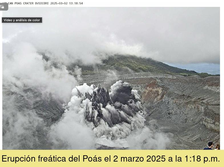
Date: 02 March 2025, 13:18 .
Plume Height (above crater): 656 feet. ( 200 meters )
Plume Observation Source:
Eruption recorded by seismographs, infrasound sensors and observed via webcam and by visitors to Poás Volcano National Park.
Observed Activity:
Moderate phreatic eruption, approximately 200 meters high, lasting 10 seconds with emission of ash, gas, water vapor and aerosols. Most of the ejected material fell back into the crater.
The eruptive plume is white with a considerable ash load, so that the water and ash column collapses to the bottom of the crater. Steam, gases and aerosols are dispersed by prevailing winds towards the western region of the volcano.
Residents of Sarchí and Llano Grande report light ashfall and a faint perception of a sulfur odor.
Activity Level: Warning
Source et photo : Ovsicori
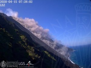
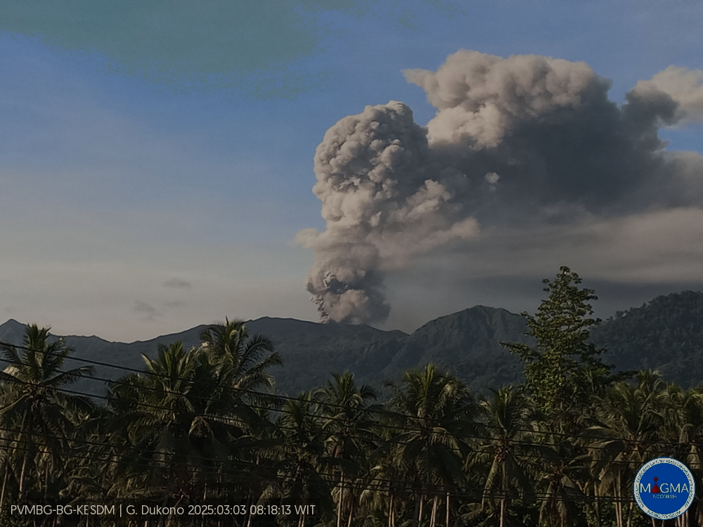
Indonesia , Dukono :
An eruption of Mount Dukono occurred on Monday, 3 March 2025 at 08:17 WIT with an observed ash column height of ±1200 m above the peak (±2287 m above sea level). The ash column was observed to be white to grey in colour with a thick intensity oriented towards the northwest. At the time of writing, the eruption was still ongoing.
Seismicity observation:
174 eruption earthquakes with an amplitude of 5 to 34 mm and a duration of 35.93 to 60.22 seconds.
2 Distant tectonic earthquakes with an amplitude of 10-14 mm, and an earthquake duration of 90.83-92.83 seconds.
1 Continuous Tremor earthquake with an amplitude of 2-4 mm, dominant value 3 mm.
Recommendation
(1) People in the vicinity of Mount Dukono and visitors/tourists should not engage in activities, climb or approach the Malupang Warirang Crater within a radius of 4 km.
(2) Since volcanic ash eruptions occur periodically and the distribution of ash follows the direction and speed of the wind, so the area where the ash falls is not constant, people around Mount Dukono are advised to always carry masks/nose and mouth covers to use when needed to avoid the threat of volcanic ash to the respiratory system.
Source et photo : Magma Indonésie .
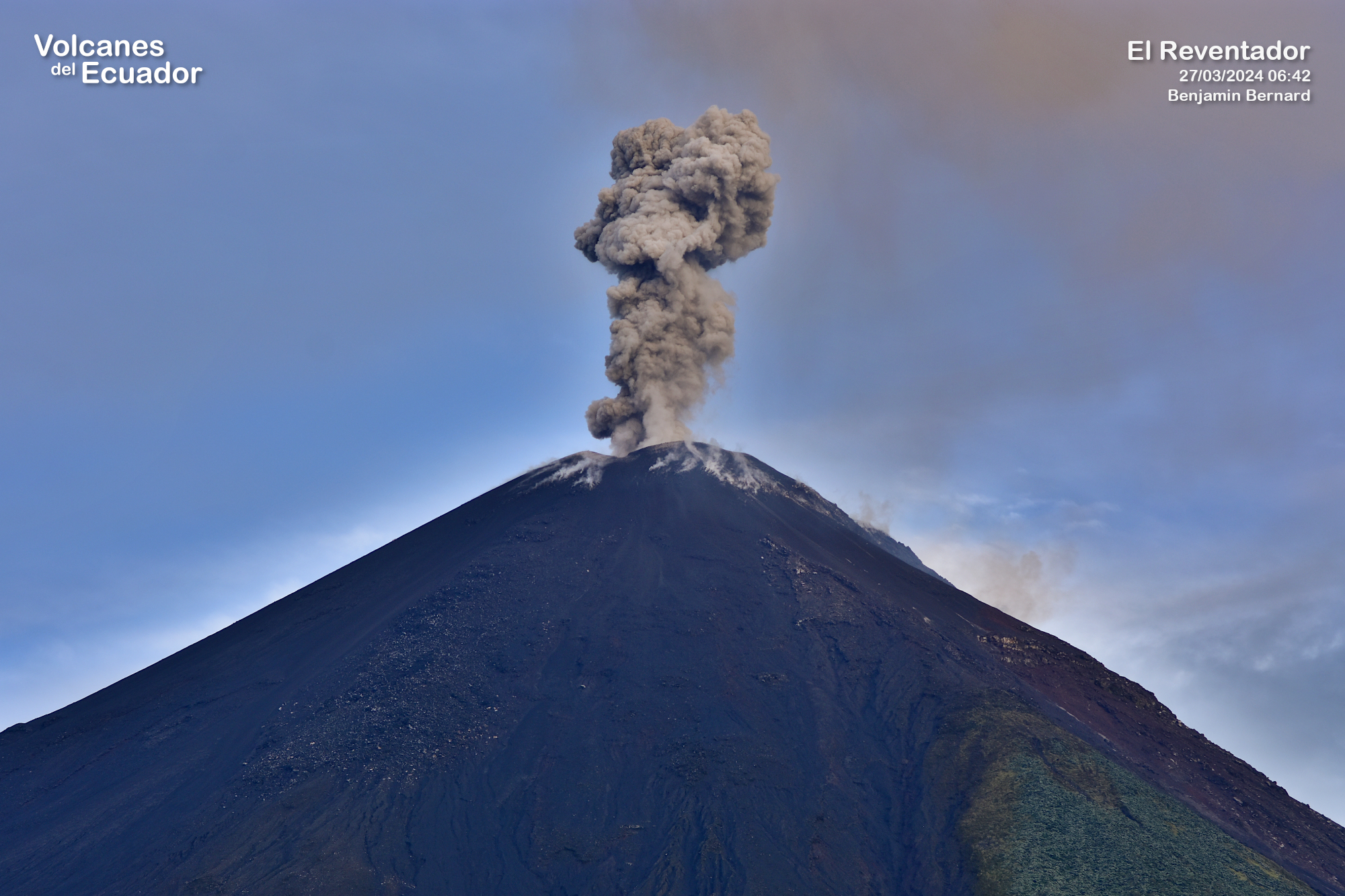
Ecuador , El Reventador .
DAILY REPORT ON THE STATE OF THE REVENTADOR VOLCANO , Sunday, March 02, 2025.
Information Geophysical Institute – EPN.
Surface Activity Level: High , Surface Trend: No changes
Internal Activity Level: Moderate , Internal Trend: No changes
From March 01, 2025, 11:00h to March 02, 2025, 11:00h:
Seismicity:
Below is the count of seismic events recorded at the reference station.
Explosion (EXP) 93
Long Period (LP) 6
Emission Tremor (TREMI) 7
Harmonic Tremor (TRARM) 3
Rainfall/Lahars:
No rain has been recorded in the volcano area. **Heavy rains could remobilize accumulated material, generating mud and debris flows that would flow down the sides of the volcano and into adjacent rivers.**
Emission/Ash Column:
Since yesterday afternoon, several emissions of gas and ash have been recorded through the surveillance camera network at heights between 700 and 1,100 meters above the crater level in the East, Southwest, South-Southeast and South-Southwest directions. Associated with this activity, the Washington VAAC agency has issued three reports of ash clouds in a South and Southwest direction with heights of 700 and 1,000 meters above the crater level.
Observation:
Despite the cloud cover in the area, several episodes of incandescent material falling on the southeast flank of the volcano up to 900 meters below the crater level were recorded by surveillance cameras yesterday evening and early this morning.
At the time of closing this report, the volcano remains completely cloudy.
Alert Level – SGR: Orange
Source : IGEPN
Photo : Benjamin Bernard / volcanes del Ecuador ( 03/ 2024) .
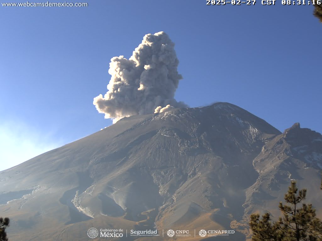
Mexico , Popocatepetl :
02 Mar, 11:00 (02 Mar, 17:00 GMT)
Activity in the last 24 hours
25 exhalations were detected, accompanied by water vapor and volcanic gases. In addition, 20 minutes of low-amplitude tremor segments were identified: 17 minutes of high frequency and 3 of harmonics.
During the morning, a light continuous emission of water vapor and volcanic gases was observed, in the Southeast (SE) direction.
The Popocatépetl volcanic alert traffic light is at yellow phase 2.
The scenarios anticipated for this phase are:
A few minor to medium-sized explosions
Appearance of a tremor of varying amplitude
Light to moderate ashfall in the surrounding towns and in some more distant towns
Ejection of incandescent fragments within a 12-kilometer exclusion radius
Lahars are likely to occur in the ravines, due to the accumulation of ash on the slopes and their interaction with the rains expected in the coming weeks.
Possibility of pyroclastic flows not reaching the populations
Source et photo : Cenapred .