February 09 , 2025.
Italy / Sicily , Etna :
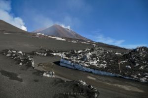
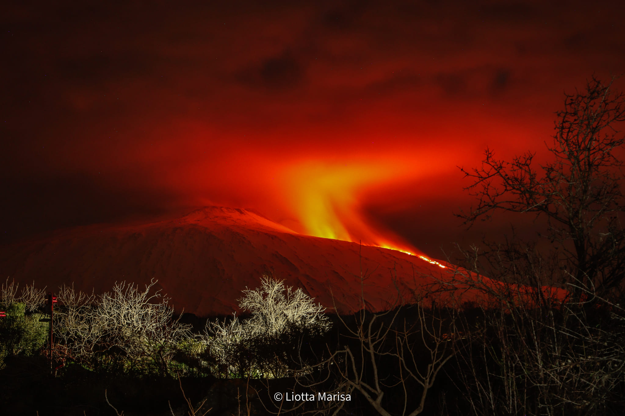
Etna Activity Report, 08 February 2025, 20:14 (19:14 UTC) .
The National Institute of Geophysics and Volcanology, Osservatorio Etneo, reports that according to the analysis of surveillance camera images and observations by INGV staff in the field, from around 17:35 (UTC), the emission of a lava flow can be observed at an estimated altitude of ~3000 meters above sea level between the base of the Bocca Nuova crater and that of the Southeast crater. The lava flow extends towards Monte Frumento Supino. This activity was preceded on 6 February by a modest and episodic explosive activity from the Southeast crater.
From a seismic point of view, the average amplitude of the volcanic tremor remains with modest oscillations in the range of average values. The centroid locations of the tremor sources seem to be located in correspondence with the Southeast Crater at an altitude between 2800 and 3000 m above sea level.
The infrasound activity currently seems almost completely absent, while for a few days, a modest infrasound activity produced by the Southeast Crater has been reported.
As for the monitoring of deformations, the GNSS network does not record significant variations, while in the last hours the inclinometric network records a very modest variation (tenths of a microradian) only at the summit station of the Cratere del Piano (ECP).
Further updates will be communicated shortly
Source : INGV
Photo : Liotta Marisa ( 09/02/2025 )
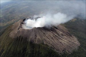
Indonesia , Ibu :
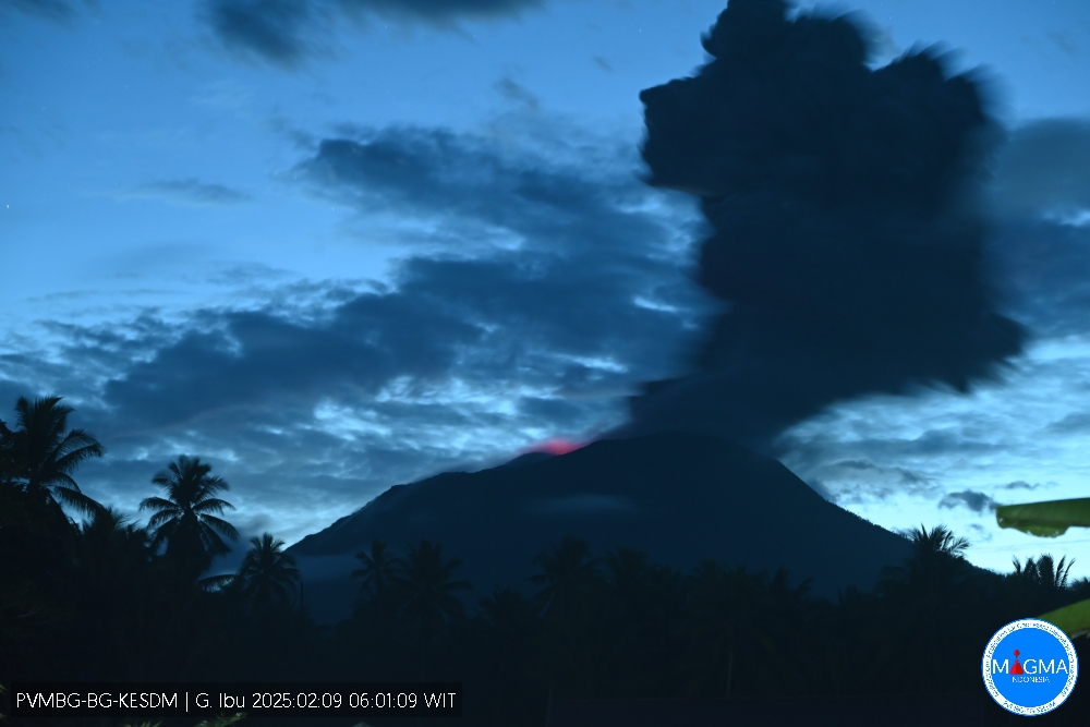
An eruption of Mount Ibu occurred on Sunday, 9 February 2025, at 06:00 WIT with an observed ash column height of ±1200 m above the peak (±2525 m above sea level). The ash column was observed to be grey in colour with a thick intensity, oriented towards the South-East. This eruption was recorded on a seismograph with a maximum amplitude of 28 mm and a duration of 107 seconds.
VOLCANO OBSERVATORY NOTICE FOR AVIATION – VONA
Issued : February 09, 2025
Volcano : Ibu (268030)
Current Aviation Colour Code : ORANGE
Previous Aviation Colour Code : orange
Source : Ibu Volcano Observatory
Notice Number : 2025IBU260
Volcano Location : N 01 deg 29 min 17 sec E 127 deg 37 min 48 sec
Area : North Maluku, Indonesia
Summit Elevation : 4240 FT (1325 M)
Volcanic Activity Summary :
Eruption with volcanic ash cloud at 21h00 UTC (06h00 local).
Volcanic Cloud Height :
Best estimate of ash-cloud top is around 8080 FT (2525 M) above sea level or 3840 FT (1200 M) above summit. May be higher than what can be observed clearly. Source of height data: ground observer.
Other Volcanic Cloud Information :
Ash cloud moving to southeast. Volcanic ash is observed to be gray. The intensity of volcanic ash is observed to be thick.
Remarks :
Eruption recorded on seismogram with maximum amplitude 28 mm and maximum duration 107 second.
Source et photo : Magma Indonésie .
Indonesia , Merapi :
MOUNT MERAPI ACTIVITY REPORT, January 31 – February 6, 2025
OBSERVATION RESULT
Visual
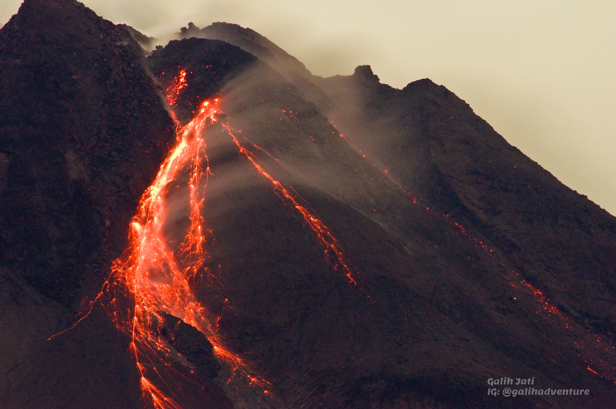
The weather around Mount Merapi is generally sunny in the morning and evening, while during the day it is hazy. White smoke, thin to thick, low to moderate pressure, with a height of 100 m was observed from Mount Merapi Kaliurang observation post on February 1, 2025 at 11:30 WIB. This week, lava avalanches were observed 88 times in the Southwest (upstream of Kali Bebeng) up to a maximum of 2,000 m, 31 times upstream of Kali Krasak up to a maximum of 2,000 m, and 13 times in the West (upstream of Kali Sat/Putih) up to a maximum of 1,800 m. The morphology of the Southwest dome was observed to have changed due to lava flow activity. For the central dome, no significant morphological changes were observed. According to the analysis of aerial photos dated January 4, 2025, the volume of the Southwest dome was measured at 3,505,900 m3. The central dome, on the other hand, measures 2,360,700 m3.
Seismicity:
This week, the seismicity of Mount Merapi recorded:
5 shallow volcanic earthquakes (VTB),
180 multiphase earthquakes (MP),
568 avalanche earthquakes (RF),
3 low frequency earthquakes (LF),
7 tectonic earthquakes (TT).
The intensity of the earthquakes this week is still quite high.
Deformation
The deformation of Mount Merapi monitored using EDM and GPS this week showed no significant changes.
Rain and lahars
This week, there was no rain at the Mount Merapi observation post and no reports of additional flows and lahars in the rivers that originate from Mount Merapi.
Conclusion
Based on the results of visual and instrumental observations, it is concluded that: The volcanic activity of Mount Merapi is still quite high in the form of effusive eruptive activity. The status of the activity is defined at the « SIAGA » level.
Source : BPPTKG
Photo : Yohannes Tyas Galih Jati ( 2021).
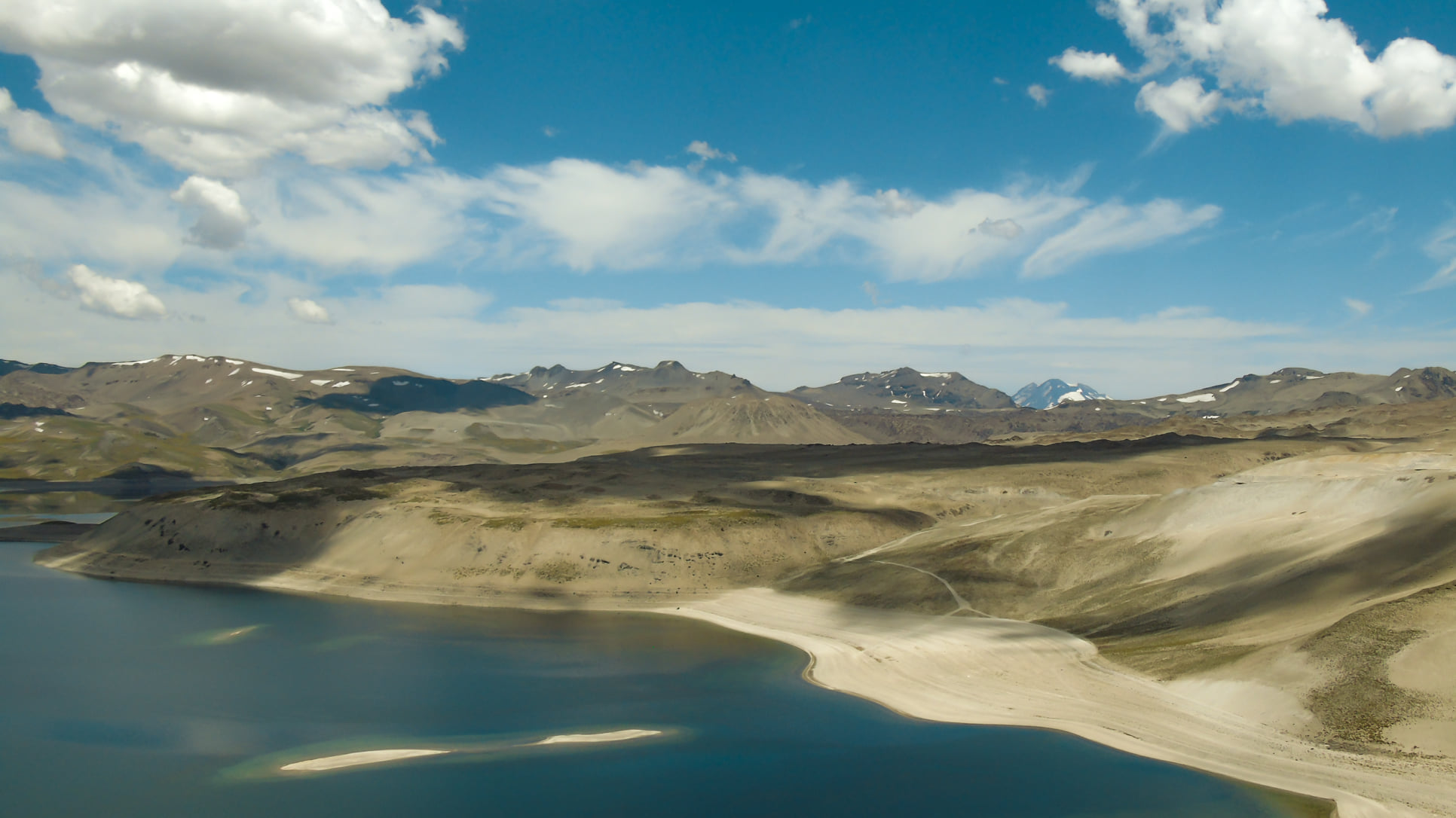
Chile , Laguna del Maule :
Seismology
The seismological activity of the period was characterized by the recording of:
1396 VT-type seismic events, associated with rock fracturing (Volcano-Tectonic). The most energetic earthquake had a local magnitude (ML) value equal to 3.0, located 13.0 km south-southeast of the volcanic building, at a depth of 5.6 km from the center of the lagoon.
2 LP-type seismic events, associated with fluid dynamics within the volcanic system (Long Period). The size of the largest earthquake estimated from the reduced displacement parameter (DR) was equal to 3 cm2.
1 VLP-type seismic event, associated with the dynamics of large volumes of fluids within the volcanic system (Very Long Period). The size of the earthquake estimated from the reduced displacement parameter (DR) was equal to 6 cm2.
Fluid Geochemistry
No anomalies in atmospheric sulfur dioxide (SO2) emissions have been reported in the area near the volcanic complex, according to data published by the Tropospheric Monitoring Instrument (TROPOMI) and the Ozone Monitoring Instrument (OMI) Sulfur Dioxide Group.
Geodesy
The geodesic activity of the period was characterized by:
Similar behavior to the historical averages recorded by the GNSS network, observing again the inflationary process with its maximum deformation in the southwest sector of the lagoon, with a maximum rate of 1.7 cm/month in the monitoring line with the greatest changes.
Similarly, based on InSar, it can be observed that the inflationary process continues at rates similar to the historical average observed in the lagoon.
Satellite thermal anomalies
During the period, no thermal alerts were recorded in the area associated with the volcanic complex, according to the analytical processing of Sentinel 2-L2A satellite images, in combination with false color bands.
Surveillance cameras
The images provided by the fixed camera, installed near the volcanic complex, did not record degassing columns or variations related to surface activity.
Satellite Geomorphological Analysis
No morphological changes associated with volcanic activity are identified based on analysis of Planet Scope and Sentinel 2 L2A satellite images in combination of true color bands for the volcanic complex.
Activity has remained at levels considered low, suggesting stability in the volcanic complex. The technical volcanic alert remains in effect for:
GREEN TECHNICAL ALERT: Active volcano with stable behavior – No immediate risk
Note: The affected area is considered to be the area within a 2 km radius of the passive CO2 degassing zone.
Source : Sernageomin
Photo : Franco Vera.
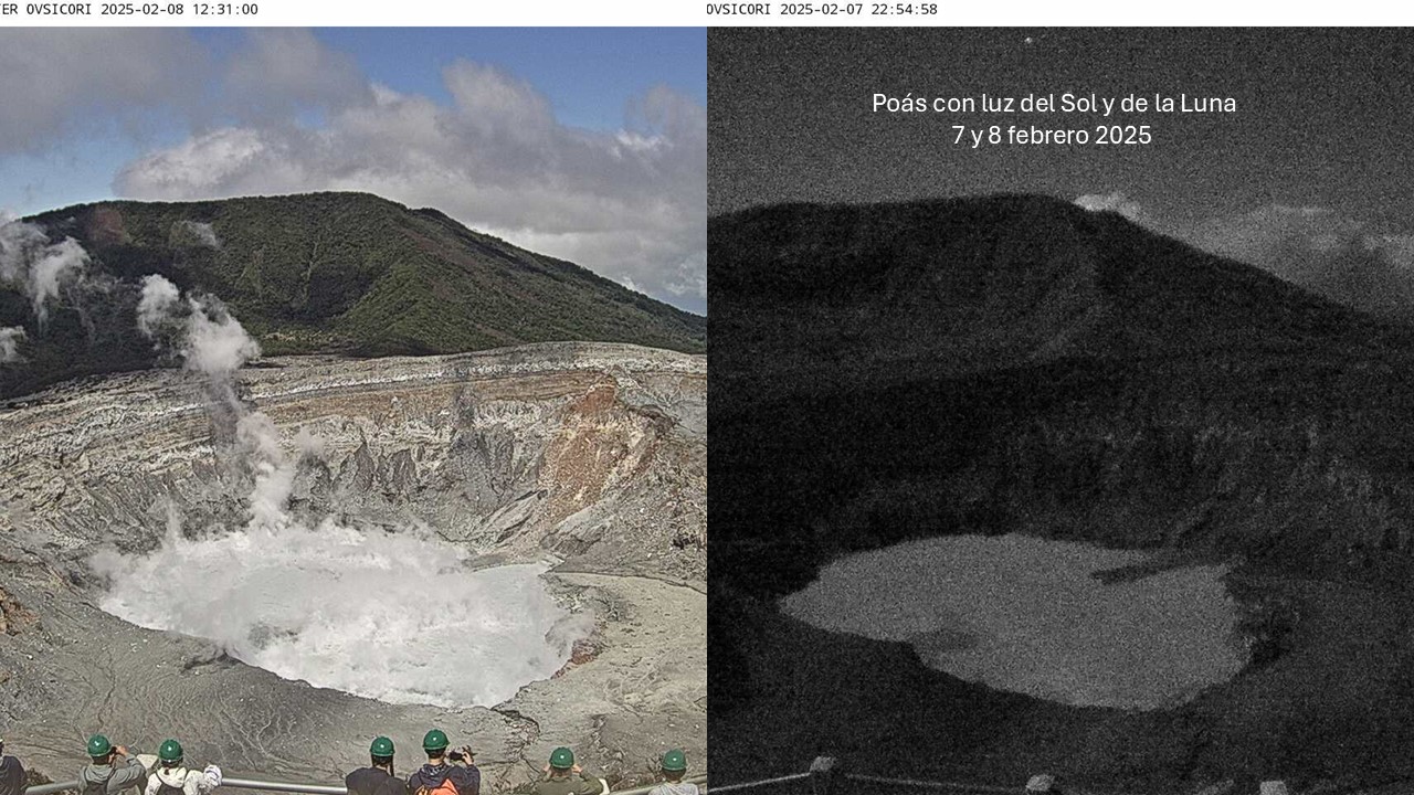
Costa Rica , Poas :
Latitude: 10.20°N;
Longitude: 84.23°W;
Altitude: 2687 m
Current Activity Level: Warning
Between 30 June and 4 February, a sequence of shallow proximal volcano-tectonic earthquakes (pVT) occurred. Few of them had tonal codas. Few long-period events are detected. At the end of the pVT sequence, changes in the background tremor were observed, including an increase in its amplitude.
Geodetic monitoring has recorded an episode of inflation since November, with the largest occurring from late December to late January. In recent days, inflation appears to have stopped. The station north of the crater shows stability, while slight subsidence is observed to the south. The model update indicates a source 1 to 3 km deep below the crater and a volume change of less than 1 Mm³.
For the past two weeks, a decrease in the SO2 flux has been observed. During the past week, the flux of this gas was 261 ± 52 t/d, while the corresponding value for the previous week was 321 ± 78 t/d. However, the SO2 flux remains high. The MultiGAS station recorded lower SO2 concentrations this week (weekly average of 5 ppm, compared to 13 ppm the previous week). The SO2/CO2 ratio remains relatively stable with an average of 1.0 ± 0.5 this week. The H2S/SO2 ratio remains low with values close to 0. The SO2 concentrations recorded at Mirador decreased this week, with a maximum of 1.5 ppm. The OMI instruments of the SENTINEL satellite have not detected SO2 in the atmosphere since January 24.
The lake level has dropped by about 0.2 m in 1 week. The temperature of the lake was measured directly on February 3 (52°C) and the pH of the water was 0.35 (hyperacid). The lake shows a slight decrease in the evaporation rate over its entire surface, but still maintains a submarine fumarolic convection. It is relevant to mention that since mid-December 2024 until today, a change in the conditions of the reduction-oxidation potential of the lake waters (REDOX potential or ORP) is observed. The ORP of the lake has gone from values around 360 mV to 298 mV, which indicates that the lake is receiving injections of less oxidized fluids in recent days, and therefore, there is a decrease in the chemical activity of water oxidation.
Source et photo : Ovsicori .