February 08 , 2025 .
Hawaii , Kilauea :
Friday, February 7, 2025, 10:23 AM HST (Friday, February 7, 2025, 20:23 UTC)
19°25’16 » N 155°17’13 » W,
Summit Elevation 4091 ft (1247 m)
Current Volcano Alert Level: WATCH
Current Aviation Color Code: ORANGE
Activity Summary:
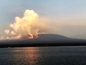
Kīlauea summit eruption paused as of February 4. A new eruptive episode may begin within the next 1-4 days in Hawai’i Volcanoes National Park.
Episode 8 of the ongoing Halemaʻumaʻu eruption ended abruptly at 7:23 p.m. HST on February 4 after about 21.5 hours of eruptive activity. Kīlauea’s current eruption in Halemaʻumaʻu crater within Kaluapele (the summit caldera) began on December 23, 2024. There have been 8 episodes of lava fountaining separated by pauses in activity. All eruptive activity remains within Hawai’i Volcanoes National Park. No significant activity has been noted along Kīlauea’s East Rift Zone or Southwest Rift Zone.
Current hazards include volcanic gas emissions and windblown volcanic glass (Pele’s Hair) that may impact Hawai’i Volcanoes National Park and nearby communities.
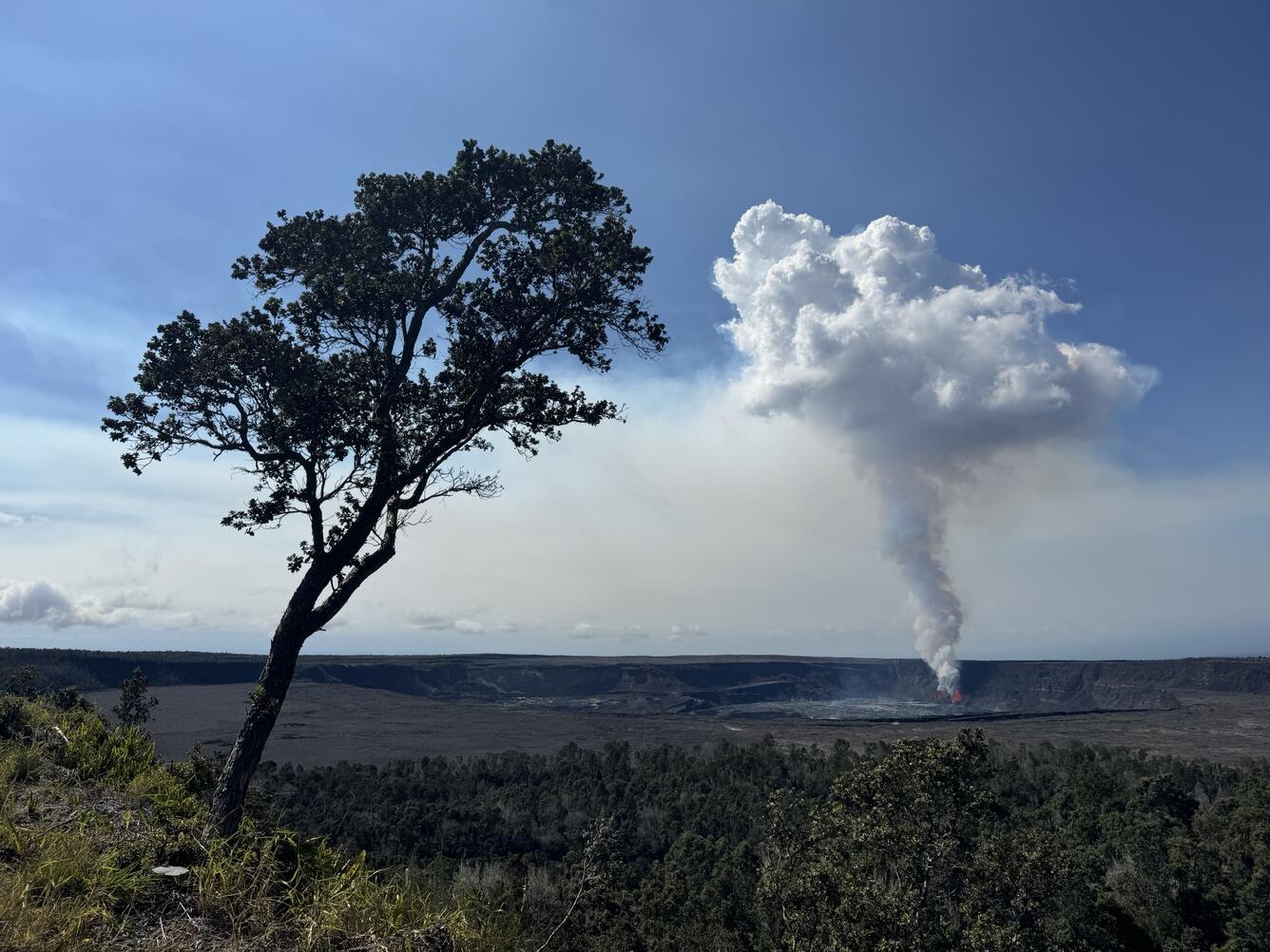
The rising gas plume from the lava fountains had a mirror-like resemblance to an ‘Ōhi‘a tree at the Volcano House.
Summit Observations:
Lava flows and fountains stopped erupting from the north vent within Halemaʻumaʻu crater at about 7:07 p.m. HST on February 4, followed by the south vent at 7:23 p.m. HST. Lava flows from episode 8 covered greater than half of the Halemaʻumaʻu crater floor. A few spots of weak orange glow can still be seen on the crater floor at night as the erupted lava continues to cool. The north vent continues to degas and glows at night, indicating magma remains at shallow levels in the vent.
Summit tilt changed rapidly from deflation to inflation, and seismic tremor decreased, at about the same time that the lava fountains stopped erupting on February 4. The Uēkahuna (UWD) and Sand Hill (SDH) tiltmeters have both recorded approximately 4 microradians of inflationary tilt since the end of episode 8. The recent instrument and data issues at UWD have been resolved. Seismic tremor decreased significantly at the end of episode 8, but remains above background. One small earthquake was recorded in the summit region over the past 24 hours.
Volcanic gas emissions remain elevated. Based on measurements made during earlier episodes and pauses, sulfur dioxide (SO2) emission rates are likely to be approximately 1,000 t/d during the current pause. An SO2 emission rate of 1,200 tonnes per day was measured on February 3.
Source : HVO
Photo : USGS / M. Patrick.
Greece , Santorini :
Since the end of January, intense seismic activity has affected the Cyclades islands, in the area between the Greek islands of Santorini and Amorgos. The swarm began on January 27 with events of magnitude less than 3 and from January 29 the magnitude of the tremors increased, reaching the maximum value Mw 5.2, with many events felt in the surrounding islands and in the city of Athens and Crete. To date, February 5, 2025 (2 p.m.), 1028 earthquakes of magnitude greater than 2 have been recorded, of which 90 have magnitudes between 4.0 and 4.9 and 3 equal to or greater than 5.0; the maximum depth is 35 km and the minimum 2 km: most of the earthquakes have a depth of about 10 km.
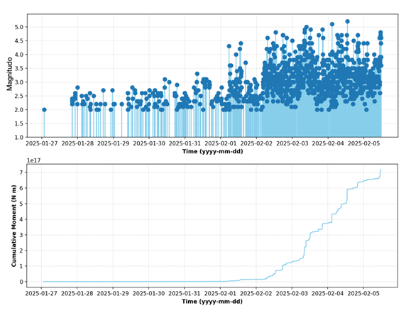
The temporal evolution of the sequence is represented in the figure above through the magnitude of the earthquakes (upper panel) and the cumulative seismic moment (lower panel). The latter provides an indication of the energy released by the sequence. The top panel of the figure shows the increase in earthquake magnitude observed since 1 February 2025, a day with a maximum recorded magnitude of 4, while at the end of January, the magnitude of localized events was less than 3. The energy released by the swarm highlights a significant increase in the number of earthquakes and their magnitude since the occurrence of the first magnitude 5.3 event on 3 February 2025.
The ongoing seismic activity is located in a large area, approximately 20-40 km northeast of the famous Santorini volcano, site of several historical eruptions, including the cataclysmic “Minoan Eruption” dated to approximately 1610 BC, one of the largest volcanic eruptions on Earth in the last 10 thousand years.
The last eruptions of Santorini, in 1570–73, 1707–11, 1866–70, 1925–26, 1928, 1939–41 and 1950, formed new islands within the caldera during the Minoan eruption, the largest of which is called Nea Kameni. These eruptions were of a slightly explosive nature, with the emission of highly viscous lava, which formed small domes and flows. In 2011–12, Santorini went through a phase of unrest, with increased seismic activity, ground deformations and changes in gas emissions from the fumaroles of Nea Kameni (Papadimitriou et al., 2015).
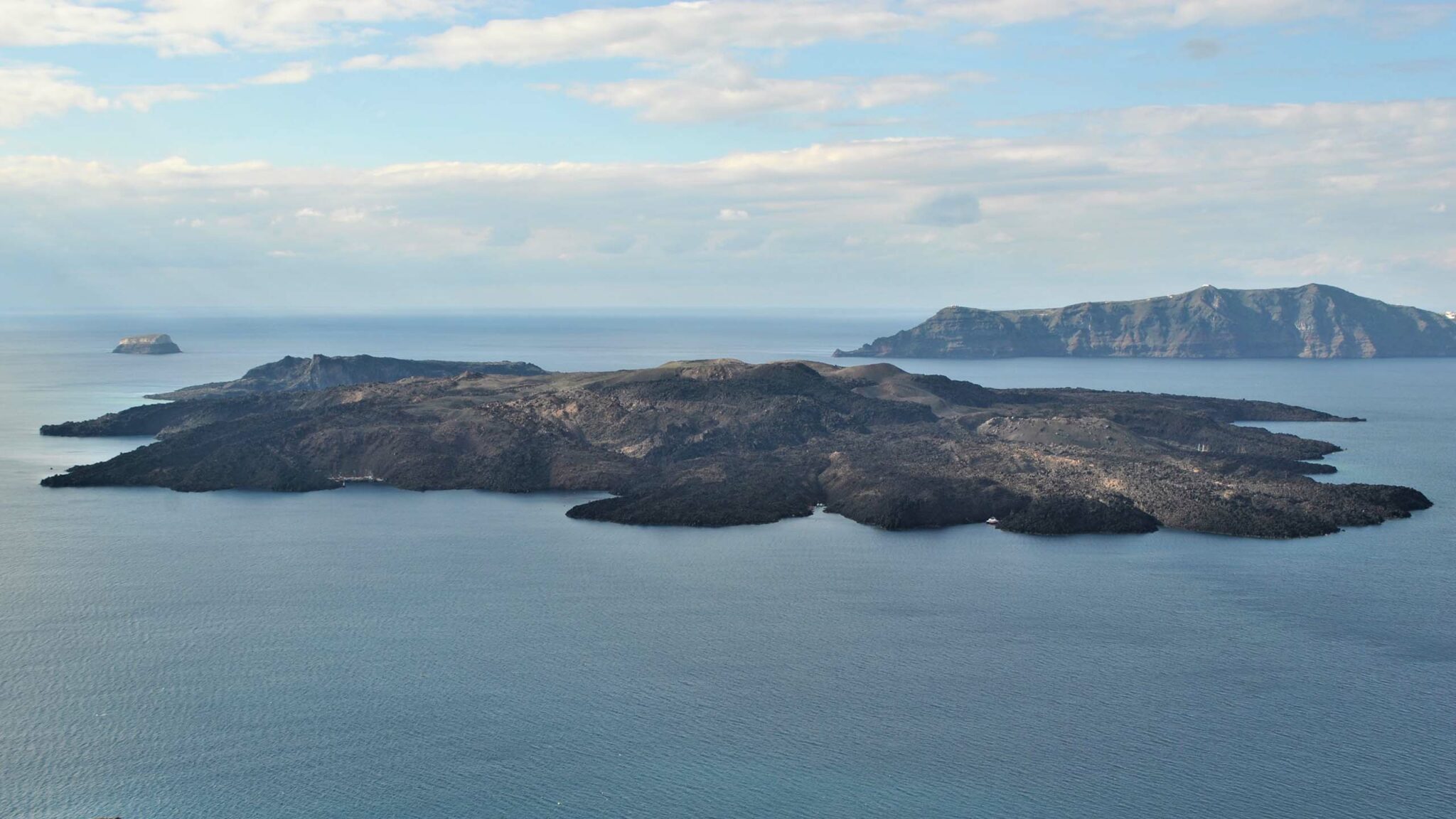
About 8 km northeast of Santorini is the submarine volcano Kolumbo, characterized by a 1.5 km wide caldera, with a summit located 10 m below sea level. In 1650, Kolumbo produced an explosive eruption that formed a new island, from which several pyroclastic flows extended to the coast of Santorini. The flows, probably in association with a tsunami, caused the death of about 70 people (Kantner et al, 2014). On this volcano, considered potentially very dangerous, underwater observatories have recently been installed, with the participation of INGV.
Source : INGV
Read the full article : https://ingvvulcani.com/2025/02/07/i-terremoti-a-santorini-isole-cicladi-grecia-febbraio-2025/
Photos : INGV , Nea Kameni National geological Park
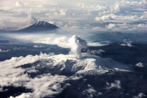
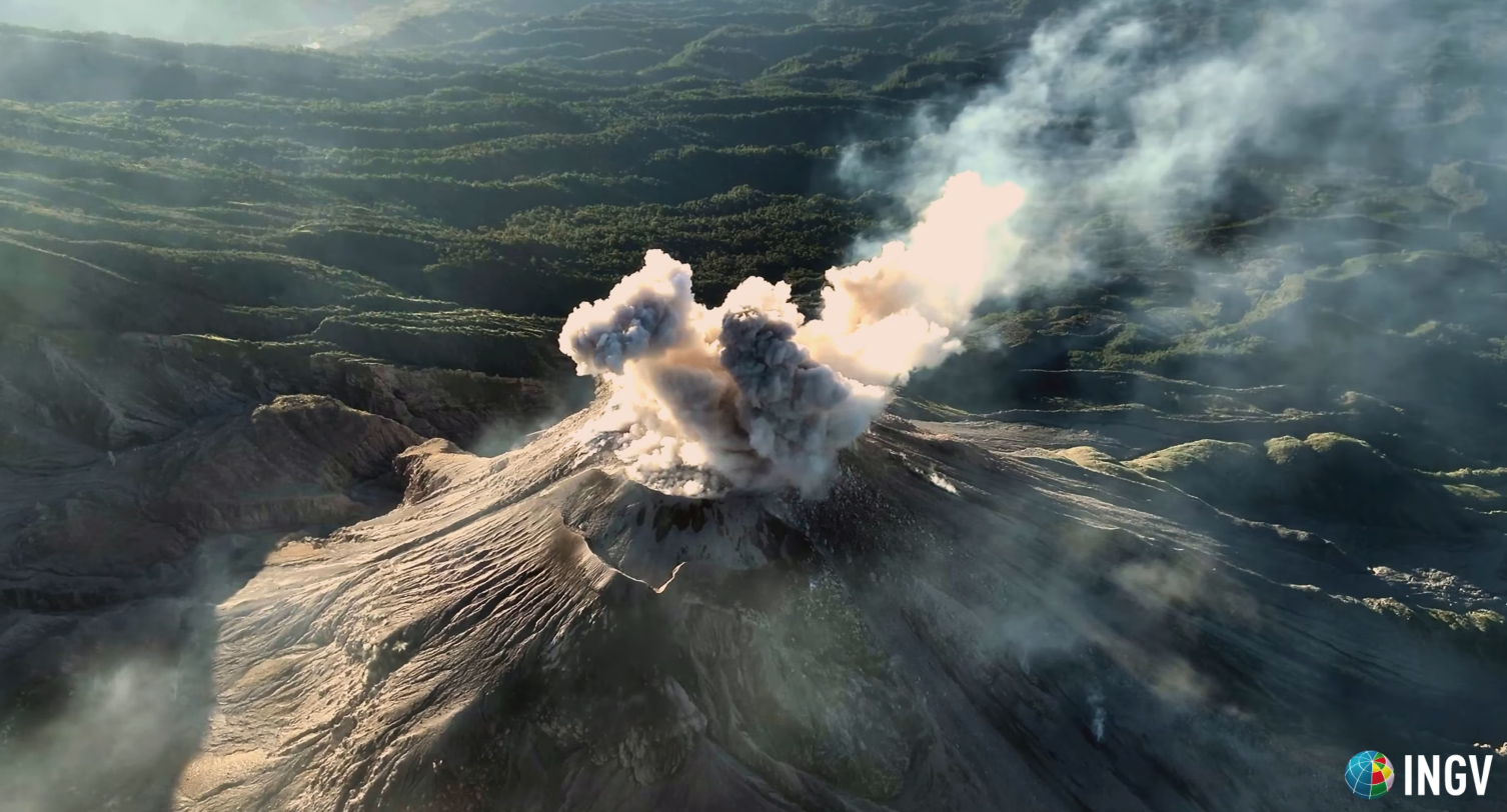
Colombia , Nevado del Ruiz :
Manizales, February 4, 2025, 12:50 p.m.
Following the monitoring of the activity of the Nevado del Ruiz volcano, the Colombian Geological Survey (SGC), an entity attached to the Ministry of Mines and Energy, reports that:
During the week of January 28 to February 4, 2025, the volcano continued to show unstable behavior. Compared to the previous week, the main variations in the monitored parameters were:
– Seismicity related to fluid dynamics inside volcanic conduits was mainly characterized by the recording of seismic signals associated with pulsatile ash emission. This type of signal increased in the number of earthquakes recorded and in the seismic energy released. On February 2 at 10:02 a.m. and 12:21 p.m., the most energetic seismic signals of the week were recorded. Thanks to the cameras (conventional or thermographic) used to monitor the volcano and the reports of the officials of the Los Nevados National Natural Park and the residents around the volcano, some of the emissions of gas and ash associated with these signals have been confirmed. Changes in the apparent temperature of the emitted material have also been observed during several of the recorded emissions.
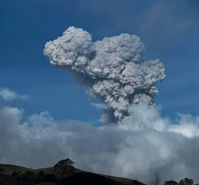
It is worth mentioning that from early today, February 4, starting at 4:30 am, a continuous emission of ash associated with long-period seismic signals has been recorded. This diffusion continues until the time of publication of this bulletin. The column of gas and ash has reached heights between 800 and 1,200 m (measured at the summit of the volcano) and is dispersing towards the southwest corner of the volcano due to the wind direction. – Seismic activity associated with rock fracturing processes within the volcanic structure has slightly increased in the number of recorded earthquakes and has maintained similar levels in the seismic energy released. Most of these events occurred on January 28 and were mainly located at distances between 5 and 6 km in the northwest direction of the Arenas crater. However, although to a lesser extent, earthquakes were recorded on other days of the week in the Arenas crater and on the different sides of the volcano, at distances of less than 5 km from the crater. In general, the seismic events were of magnitudes less than 1 (low energy level) and occurred at depths between 1 and 6 km from the summit of the volcano.
– The emission of water vapor and gases, mainly sulfur dioxide (SO₂), into the atmosphere through the Arenas crater was variable with similar values in the daily degassing rates of SO₂ compared to the previous week. In the satellite monitoring, carried out in a complementary manner to evaluate this parameter, significant releases of SO₂ into the atmosphere were highlighted.
– The vertical height of the gas or ash column showed a similar behavior to the previous week, maintaining values mainly below 800 m and reaching a maximum of 1300 m. In dispersion, the column reached 2000 m. These values measured at the summit of the volcano were estimated during the ash emission on January 30 at 15:07 . Regarding the direction of dispersion of the column, it presented a predominant trend towards the West-Southwest of the volcano throughout the week, with occasional variations towards the Northwest and Southwest. – When monitoring thermal anomalies at the bottom of the Arenas crater, using satellite monitoring platforms, some reports of low energy level anomalies were obtained.
Source : SGC
Photo : Entérate Ciénaga
Indonesia , Marapi :
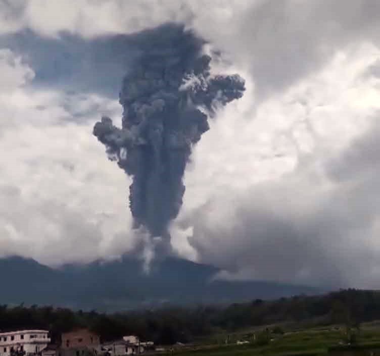
An eruption of Mount Marapi occurred on Saturday, February 8, 2025 at 04:30 WIB. No images of the eruption were observed. This eruption was recorded on a seismograph with a maximum amplitude of 30.3 mm and a duration of 38 seconds.
VOLCANO OBSERVATORY NOTICE FOR AVIATION – VONA
Issued : February 08 , 2025
Volcano : Marapi (261140)
Current Aviation Colour Code : YELLOW
Previous Aviation Colour Code : yellow
Source : Marapi Volcano Observatory
Notice Number : 2025MAR013
olcano Location : S 0 deg 22 min 52 sec E 100 deg 28 min 23 sec
Area : West Sumatra, Indonesia
Summit Elevation : 9251 FT (2891 M)
Volcanic Activity Summary :
Increasing in volcanic activity.
Volcanic Cloud Height :
Ash-cloud is not observed.
Other Volcanic Cloud Information :
Ash-cloud is not observed.
Remarks :
Eruption and ash emission is continuing. Eruption recorded on seismogram with maximum amplitude 30.3 mm.
Source : Magma Indonésie.
Photo : Jro Yudhiani ( 23/08/2024 FB via Volcanodiscovery)
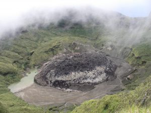
Guatemala , Santiaguito :
Weather conditions: Clear.
Wind: East.
Precipitation: 0.0 mm.
Activity:
The Santa María-Santiaguito Volcanic Complex Observatory reports volcanic activity on the Caliente dome, consisting of a weak white degassing with columns of water vapor and other magmatic gases at heights of 250 to 400 meters above the dome, as well as weak to moderate explosions that occur at a rate of 1 to 3 per hour, which raise columns of gas and ash up to 700 meters high above the Caliente dome, moving towards the West. In the early morning, an incandescence was observed in the dome and on the promontory above the lava flow, also due to the detachment of blocks towards the southwest and south flanks caused by some explosions.
Blocky lava extrusion continues to accumulate unstable and high materials on the promontory above the lava flow on the southwest flank. The detachment of these blocks could generate pyroclastic flows over short distances on the southwest flank. A small fall of ash particles could be recorded in the areas located west of the domes, between San Marcos Palajunoj and San Martín Sacatepéquez. The activity remains at a high level, which means that there is a possibility of generating pyroclastic flows over long distances towards the southwest, south and southeast.
Source : Insivumeh .
Photo : capture d’écran INGV Dr. Riccardo Civico