November 13 , 2024.
Indonesia , Lewotobi Laki-laki / Ibu :
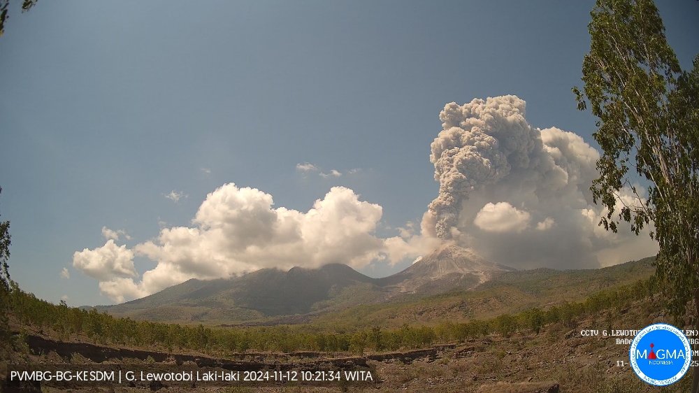
An eruption of Lewotobi Laki-laki occurred on Tuesday, 12 November 2024, at 10:14 WITA with the height of the ash column observed at ±1,500 m above the summit (±3,084 m above sea level). The ash column was observed to be grey with thick intensity, oriented towards the southwest and west. At the time of writing, the eruption was still ongoing.
VOLCANO OBSERVATORY NOTICE FOR AVIATION – VONA
Issued : November 12 , 2024
Volcano : Lewotobi Laki-laki (264180)
Current Aviation Colour Code : ORANGE
Previous Aviation Colour Code : orange
Source : Lewotobi Laki-laki Volcano Observatory
Notice Number : 2024LWK773
Volcano Location : S 08 deg 32 min 20 sec E 122 deg 46 min 06 sec
Area : East Nusa Tenggara, Indonesia
Summit Elevation : 5069 FT (1584 M)
Volcanic Activity Summary :
Eruption with volcanic ash cloud at 02h14 UTC (10h14 local).
Volcanic Cloud Height :
Best estimate of ash-cloud top is around 9869 FT (3084 M) above sea level or 4800 FT (1500 M) above summit. May be higher than what can be observed clearly. Source of height data: ground observer.
Other Volcanic Cloud Information :
Ash cloud moving from southwest to west. Volcanic ash is observed to be gray. The intensity of volcanic ash is observed to be thick.
Remarks :
Eruption and ash emission is continuing. Eruption recorded on seismogram with maximum amplitude 47.3 mm.
———————————————
Ibu erupted on Tuesday, 12 November 2024 at 08:13 WIT with the height of the ash column observed at ± 1,500 m above the summit (± 2,825 m above sea level). The ash column was observed to be grey with a thick intensity, oriented towards the southwest and west. This eruption was recorded on a seismograph with a maximum amplitude of 28 mm and a duration of 85 seconds.
VOLCANO OBSERVATORY NOTICE FOR AVIATION – VONA
Issued : November 12 , 2024.
Volcano : Ibu (268030)
Current Aviation Colour Code : ORANGE
Previous Aviation Colour Code : orange
Source : Ibu Volcano Observatory
Notice Number : 2024IBU1061
Volcano Location : N 01 deg 29 min 17 sec E 127 deg 37 min 48 sec
Area : North Maluku, Indonesia
Summit Elevation : 4240 FT (1325 M)
Volcanic Activity Summary :
Eruption with volcanic ash cloud at 23h13 UTC (08h13 local).
Volcanic Cloud Height :
Best estimate of ash-cloud top is around 9040 FT (2825 M) above sea level or 4800 FT (1500 M) above summit. May be higher than what can be observed clearly. Source of height data: ground observer.
Other Volcanic Cloud Information :
Ash cloud moving from southwest to west. Volcanic ash is observed to be gray. The intensity of volcanic ash is observed to be thick.
Remarks :
Eruption recorded on seismogram with maximum amplitude 28 mm and maximum duration 85 second.
Source : Magma Indonésie
Italy / Sicily , Etna :
WEEKLY BULLETIN, from November 04, 2024 to November 10, 2024 . (issue date November 11, 2024 )
SUMMARY STATUS OF ACTIVITY
In light of the monitoring data, it appears:
1) VOLCANOLOGICAL OBSERVATIONS: Lava fountain activity from one of the summit craters (not determinable with certainty due to weather conditions). Degassing activity from the other craters.
2) SEISMOLOGY: No seismic activity due to fracturing with Ml>=2.0; the amplitude of the shaking varied from medium-low levels to high levels recorded during the lava fountain episode.
3) INFRASOUND: Strong infrasound activity in conjunction with the lava fountain episode at the summit craters.
4) GROUND DEFORMATIONS: The inclinometric network recorded the deformations associated with the volcanic event of November 10. The GNSS network did not record any significant trend changes.
5) GEOCHEMISTRY: SO2 flux at medium level
The CO2 flux from the soil is at medium-high values.
The partial pressure of CO2 dissolved in groundwater has values within the seasonal variability.
The isotopic ratio of Helium in peripheral sites is at high values (last updated on 14/10/2024)
6) SATELLITE OBSERVATIONS: The thermal activity observed by satellite in the summit area was generally low to moderate, poor visibility conditions affected the analysis
of satellite images.
VOLCANOLOGICAL OBSERVATIONS
During the week in question, the monitoring of the volcanic activity of Etna was carried out through the analysis of images from the surveillance camera network of the National Institute of Geophysics and Volcanology – Osservatorio Etneo (INGV-OE).
Due to unfavourable weather conditions, observation of the volcanic edifice and in particular of the summit craters was impossible for a large part of the period.
In the rare flashes of weather when observation by cameras was possible, Etna’s activity was characterised by continuous degassing of varying intensity at the summit craters and in particular at the eastern mouth of the South-East crater, and of the Voragine crater, made particularly evident – especially in the absence of wind – by the high levels of atmospheric humidity that characterised the weather conditions of the period.
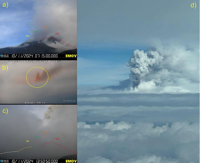
a) Degassing activity of the summit craters, recorded on the morning of 10/11 by the Montagnola camera (EMOV); b) eruptive activity in the summit area at 10:44 UTC, filmed by a webcam of the Vedetta.org network; c) significant ash emission visible in a small breach in the thick cloud cover at 13:50 UTC from the Montagnola camera (EMOV); d) eruptive column crossing the cloud cover, recorded on the morning of 11/10 by an airline pilot.
On 10 November, from about 09:40 UTC to about 18:00 UTC, the geophysical signals showed variations consistent with the development of lava fountaining activity. As mentioned in the introduction, due to unfavourable weather conditions, it was not possible to make direct observations of the ongoing phenomenon and, therefore, it was not possible to determine with certainty which of the summit craters produced it.
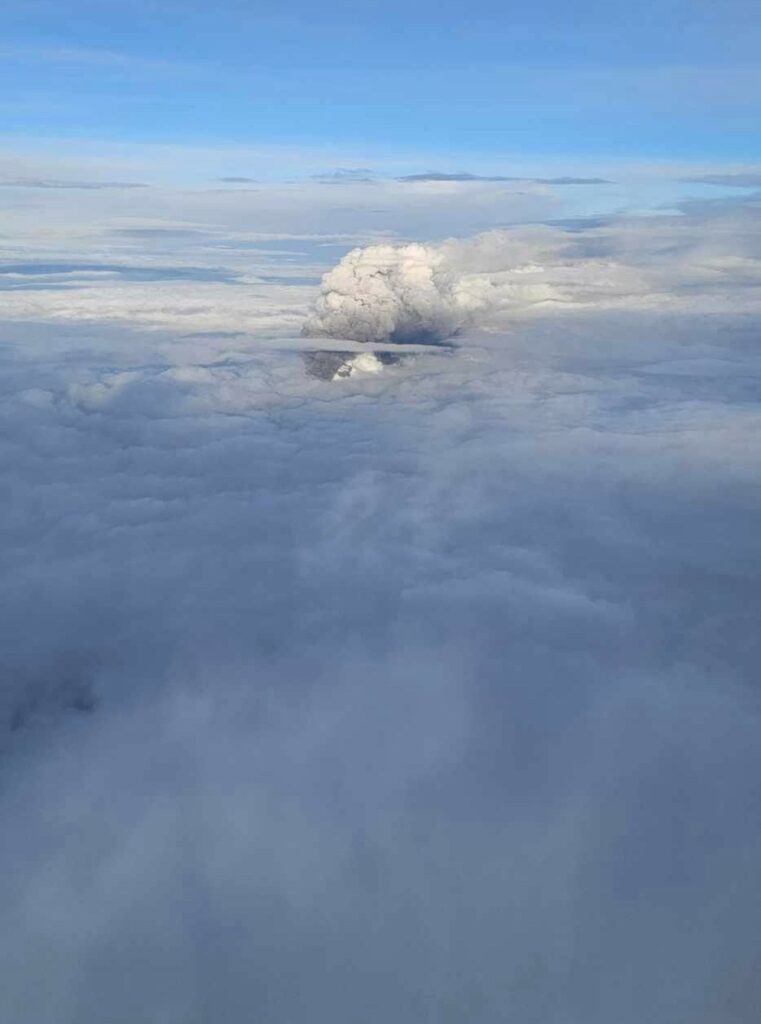
The only information available on the state of the volcano shows: at 07:15 an ordinary summit degassing activity, comparable to that of the previous period; at 10:44 UTC, a webcam from the Vedetta.org Live Webcams network highlights eruptive activity in the summit area; at 13:50 UTC, the Montagnola Visible Camera (EMOV) shows a significant emission of ash from a small breach in the thick cloud cover; in the morning, an airline pilot publishes a photo in which an eruptive column is observed crossing the cloud cover, which can be associated with the activity of a lava fountain.
The eruptive column reached an altitude of about 9500 m above sea level (according to MSG – Meteosat image processing) and dispersed in the eastern sector, causing ash fallout, reported from 10:45 UTC on the towns of Milo, Fornazzo, Mascali, Torre Archirafi.
The weather conditions made sampling operations of the distal pyroclastic deposit difficult: however, a deposit of modest size compared to that of previous lava fountains was observed in the sampling sites.
Source : INGV
Photos : Via Wulkany Swiata , INGV.
Italy , Stromboli :
WEEKLY BULLETIN, from November 04, 2024 to November 10, 2024. (issue date November 11, 2024)
SUMMARY STATUS OF ACTIVITY
In light of the monitoring data, it emerges:
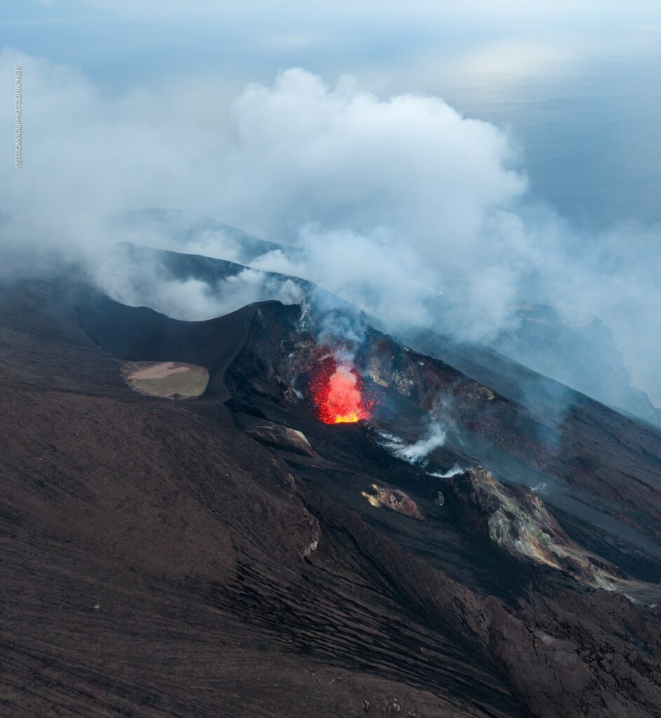
1) VOLCANOLOGICAL OBSERVATIONS: During this period, intense eruptive activity was observed with splashes coming from the northern area of the crater that produced some lava flows. The total hourly frequency fluctuated between average values (6 to 10 events/hour). The intensity of the explosions was low in the northern crater area and medium to high in the central-southern area.
2) SEISMOLOGY: The monitored seismological parameters do not show any significant variations, except for the sudden increase in the tremor amplitude which increased to values between HIGH and VERY HIGH from 8 November.
3) GROUND DEFORMATIONS: The ground deformation monitoring networks of the island did not show any significant changes to report for the period under review.
4) GEOCHEMISTRY: SO2 flux at medium level
CO2 flux from the ground in the STR02 summit area at very high values.
C/S ratio in the plume: is at very high values.
Helium isotope ratio in the thermal aquifer: there are no updates. Latest data from 24/10/2024 on average values
CO2 flow at Mofeta in the San Bartolo area: in average values.
CO2 flux at Scari: values around 220 g/m2/day.
5) SATELLITE OBSERVATIONS: The thermal activity observed by satellite in the summit area was generally low to moderate in correspondence with the eruptive activity in the northern crater area on 6 November 2024.
VOLCANOLOGICAL OBSERVATIONS
During the observed period, the eruptive activity of Stromboli was characterized through the analysis of images recorded by the INGV-OE surveillance cameras located at 190 m altitude (SCT-SCV) and at Punta dei Corvi (SPCT). The explosive activity was mainly produced by four eruptive chimneys located in the North crater area and by three chimneys located in the Centre-South area.
Since 6 November, an intense spattering activity in the North crater area has produced lava flows inside the Sciara del Fuoco.
Observations of explosive activity captured by surveillance cameras
In the North Crater (N) area, four active vents were observed that produced low-intensity explosive activity (less than 80 m in height) and sometimes medium-intensity (less than 150 m in height).
In addition, splashes were observed, sometimes intense, on 6 and 9 November. The products emitted during the eruption were mainly coarse materials (bombs and lapilli). The average frequency of explosions ranged from 4 to 9 events/hour.
In the Centre-South (CS) area, explosive activity was produced by at least three chimneys, the explosions varied in intensity from medium (less than 150 m in height) to high (more than 250 m in height) emitting fine materials mixed with coarse materials. The average frequency of explosions ranged from 1 to 3 events/hour.
Lava flows from 6 to 10 November 2024
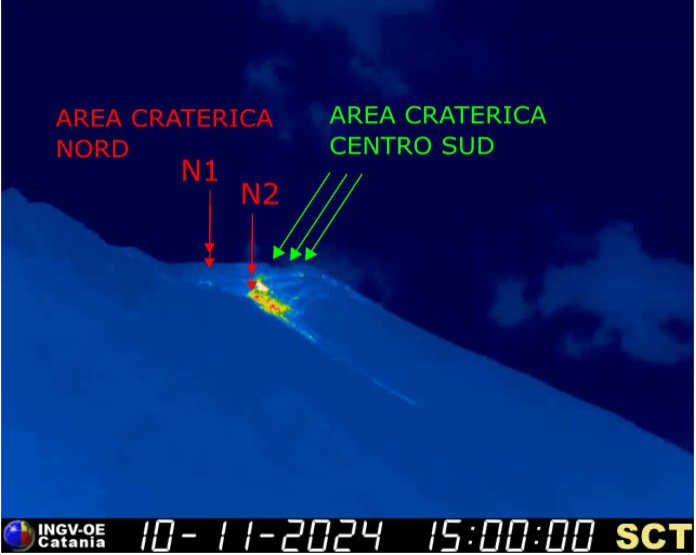
The vents located in the area of the North Crater and identified in Fig. 3.1 as N2 from 6 November until the end of the period analyzed (10 November), after an intense activity of projections, produced lava flows that flowed along the Sciara del Fuoco and as in the flow of 6 November, some blocks reached the coastline. It should be noted that the volumes of flows placed along the Sciara were modest.
Below is the chronology of the two most significant flows. The times are in UTC format.
On 6 November, from 17:16, a projection activity begins, which becomes intense after a few minutes and begins to flow along the Sciara . This lasted a few hours and some blocks reached the coastline.
On 7 November, starting at 09:38, a splashing activity began that became intense after a few minutes and began to flow along the Sciara. This expansive episode lasted about an hour.
In the following days (8-9-10 November), after an intense splashing activity, small rheomorphic flows were located in the upper part of the Sciara.
Source : INGV
Photos : INGV , Stromboli stati d’animo / Sebastiano Cannavo
Colombia , San José de Mulatos :
On the afternoon of November 11, 2024, the communities of San José de Mulatos, in Antioquia, reported the possible eruption of a mud volcano, information already confirmed by the Colombian Geological Survey.
Although at first it was said that the volcano that could have erupted was San José de Mulatos, it was really the Los Aburridos volcano, which had already erupted ten years ago with little impact. Tomorrow, November 12, a group of experts from the SGC will be in the affected area carrying out the respective studies.
In Colombia, between the departments of Atlántico, Córdoba, Sucre, Bolívar and Antioquia, in areas near the Caribbean, there are hundreds of mud volcanoes, some of them, such as Turbaco, described since the beginning of the 19th century by the German geographer and naturalist Alexander von Humboldt and other researchers. However, most of them were discovered in the course of geoscientific research carried out, for the most part, in the last three decades.
These volcanoes are evidence of mud diapirism, a phenomenon generated by intense bacterial activity on the mud accumulated on the seabed where large amounts of sediment and organic matter penetrate and are buried in the subsoil. Because it is a process that has occurred over almost 20 million years, the accumulation of more and more sediments exerts high pressure on the organic matter and generates its partial transformation into gas, leading to, due to the differences between the density and chemical composition of the mud rich in organic matter, and the thicker sediments, a bulge occurs on the surface and the mud, water and methane exit.
The threat caused by the manifestations of this type of volcanoes is related to the flow of mud towards agricultural areas and homes, cracks in the ground and possible explosiveness of gases (in Colombia, mud volcanoes that have presented explosive events related to the release of methane are located in sparsely populated areas).
Although the SGC has ventured into understanding the phenomenon of mud diapirism from several projects carried out in the last 30 years, the entity’s research has focused on magmatic volcanoes in the Central Mountain Range and the Colombian Massif. For this reason, the study of current mud volcanism is necessary for risk management, and not only in continental areas, since many of them have manifestations on the seabed, both in the Caribbean and in the Colombian Pacific.
Source : SGC.
Photo : Elig Garcia Mar
Hawaii , Kilauea :
Tuesday, November 12, 2024, 10:17 AM HST (Tuesday, November 12, 2024, 20:17 UTC)
19°25’16 » N 155°17’13 » W,
Summit Elevation 4091 ft (1247 m)
Current Volcano Alert Level: ADVISORY
Current Aviation Color Code: YELLOW
Activity Summary:
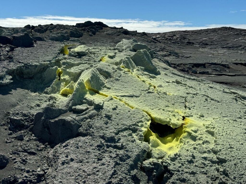
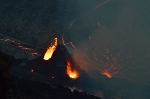
Kīlauea volcano is not erupting. Seismicity and ground deformation at the volcano’s summit, East Rift Zone, and Southwest Rift Zone are low.
Summit Observations:
Earthquake activity at Kīlauea’s summit region remained low over the past week, with 19 earthquakes magnitude-2.2 or smaller. The tiltmeter at Uēkahuna, northwest of Kaluapele, the summit caldera, remained relatively flat with no significant changes over the past week. The tiltmeter at Sand Hill, southwest of Kaluapele, continues to show slow inflation (about 2 microradians over the past week). The most recent measurement of the sulfur dioxide (SO2) emission rate from the summit was approximately 60 tonnes per day on September 17, a value representative of noneruptive conditions at Kīlauea.
Rift Zone Observations:
Shallow earthquake counts in the upper and middle East Rift Zone (ERZ) were low over the past week, with 25 magnitude-2 or smaller earthquakes in upper ERZ and 39 magnitude-2.2 and smaller earthquakes in middle ERZ. GPS instruments in the middle ERZ region show continued slow inflation and extension of this region over the past week.
Recent eruptive activity occurred in the middle East Rift Zone in and near Nāpau Crater, between Makaopuhi Crater and Puʻuʻōʻō. There are no indications of any changes downrift in the lower East Rift Zone.
Source : HVO
Photo : USGS / M. Patrick. ( 7/2024)

