October 25 , 2024.
Hawaii , Kilauea :
HAWAIIAN VOLCANO OBSERVATORY DAILY UPDATE , Wednesday, October 23, 2024, 8:35 AM HST (Wednesday, October 23, 2024, 18:35 UTC)
19°25’16 » N 155°17’13 » W,
Summit Elevation 4091 ft (1247 m)
Current Volcano Alert Level: ADVISORY
Current Aviation Color Code: YELLOW
Activity Summary:
Kīlauea volcano is not erupting. Weak steaming is occasionally visible on the inactive September 15–20 lava flow field within Nāpau Crater on the middle East Rift Zone. No changes have been detected in the summit, lower East Rift Zone, or Southwest Rift Zone.
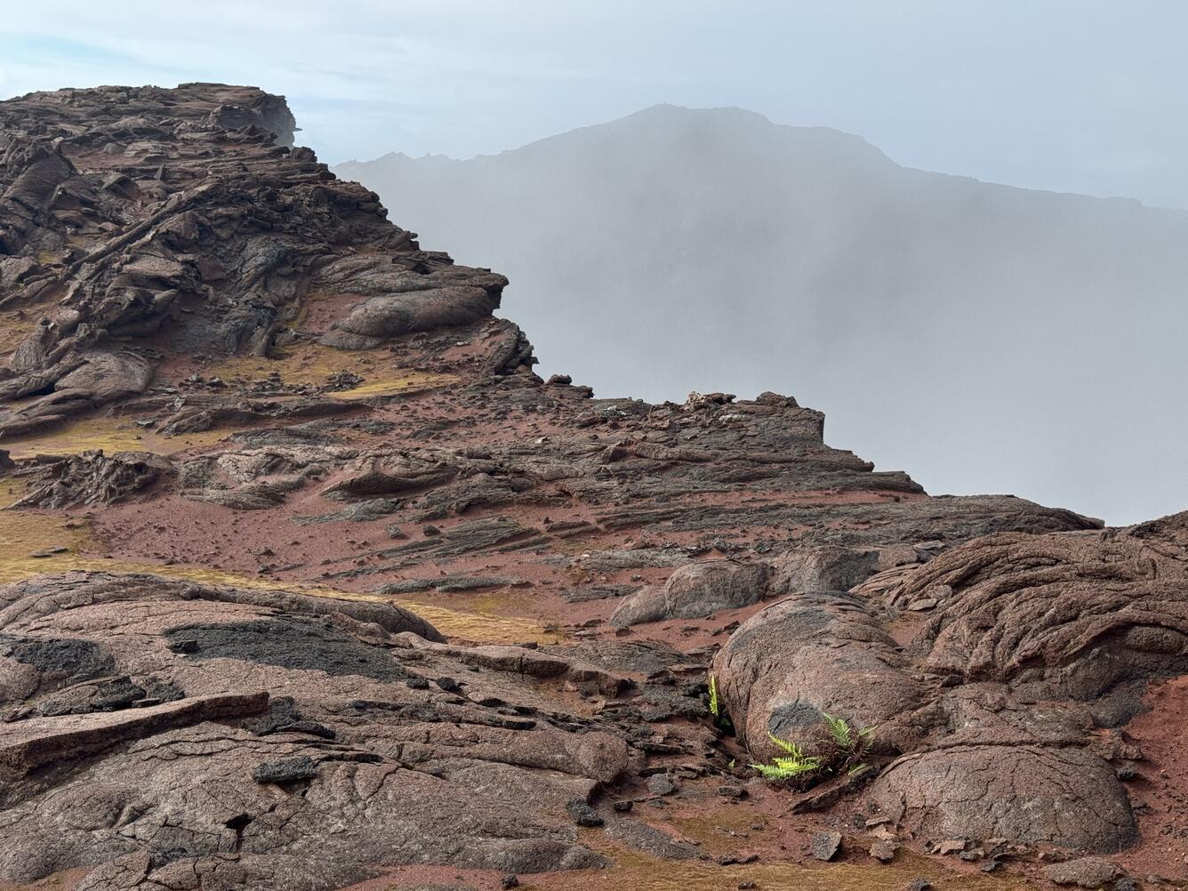
This photo looks west along the south rim of Pu‘u‘ō‘ō. Red ash from the collapses during 2018 fills depressions in the lava flows, allowing moss and small ferns to grow. Green vegetation such as this was not observed by geologists near the rim during the 1983-2018 eruption, presumably due to high gas concentrations.
Summit Observations:
There were 15 earthquakes detected beneath the Kīlauea summit region over the past 24 hours. The summit tiltmeters at Uēkahuna and Sandhill are relatively flat over the past day. The most recent measurement of the sulfur dioxide (SO2) emission rate at the summit was approximately 60 tonnes per day on September 17, 2024.
Rift Zone Observations:
The middle East Rift Zone (MERZ) eruption near Nāpau Crater stopped around 10 a.m. HST on the morning of September 20. Only occasional weak steaming from the eruption site has been seen in webcam imagery since that time. No SO2 from the eruption site was detected on September 23 during measurements on Chain of Craters Road, indicating that the MERZ SO2 emissions are negligible.
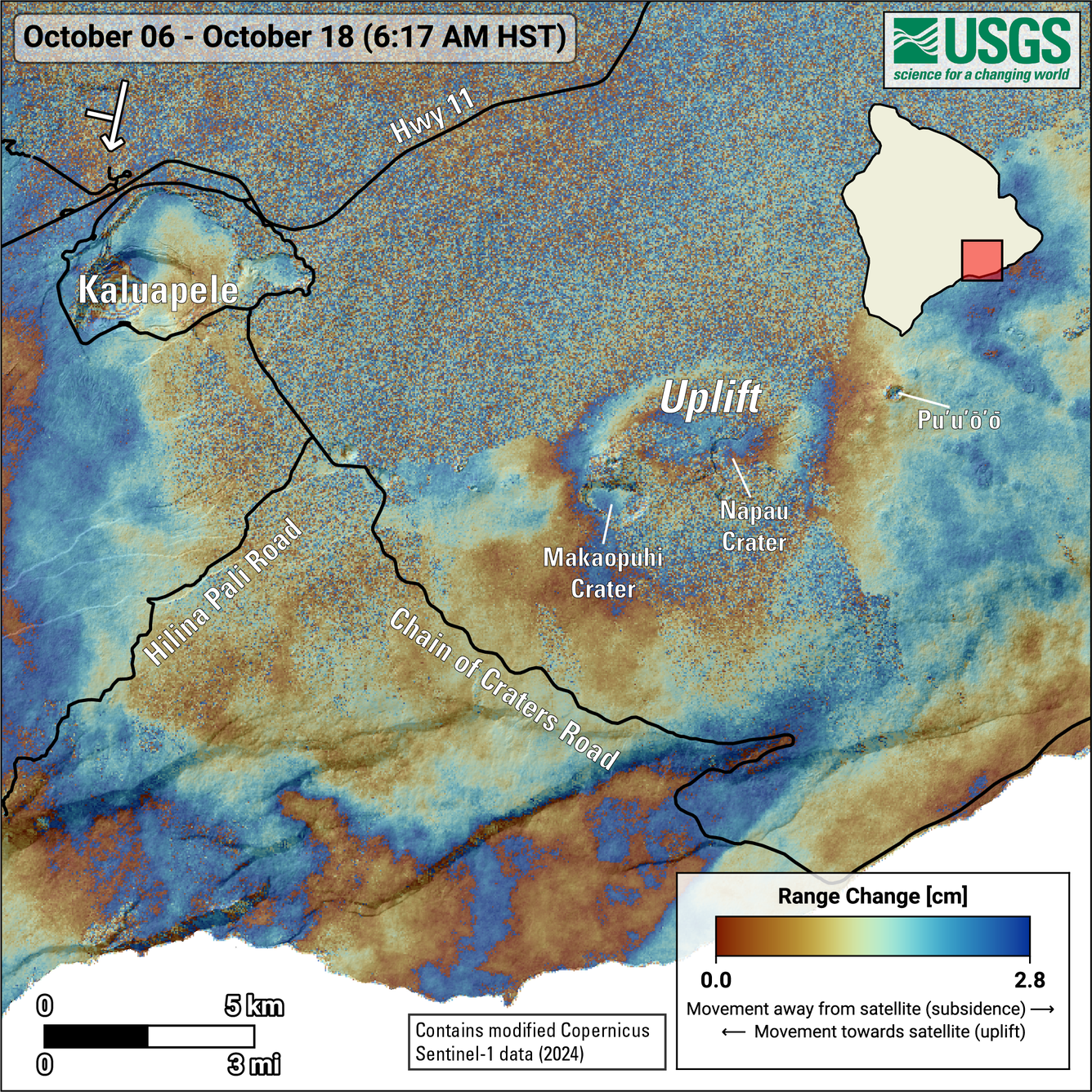
This map shows recent deformation at Kīlauea over the timeframe of October 6–18, 2024. Data were acquired by the European Space Agency’s Sentinel-1 satellites. Colored fringes denote areas of ground deformation, with more fringes indicating more deformation. Each color cycle represents 2.8 cm (1.1 in) of ground motion. The symbol in the upper left indicates the satellite’s orbit direction (arrow) and look direction (bar). The round feature north of Nāpau and Makaopuhi Craters on the middle East Rift Zone indicates ground surface inflation over this time period as magma accumulates underground near the recent September 15–20, 2024, eruption site. Fringes at Kaluapele are due to new topography created by past lava flows, that has not yet been incorporated into our digital elevation model (DEM).
Shallow earthquake counts were slightly elevated over the past day with 67 earthquakes in the middle and upper East Rift Zone, and no tremor being recorded on seismometers near the recent eruption site. Tiltmeters in the MERZ show modest deflation and GPS instruments show low rates of deformation.
All recent activity was confined to the MERZ between Makaopuhi Crater and Puʻuʻōʻō and there are no indications of any changes downrift in the lower East Rift Zone.
Source : HVO
Photo : USGS / M. Patrick ( 23/10/2024) , USGS / Sentinel-1
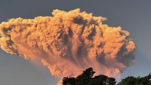
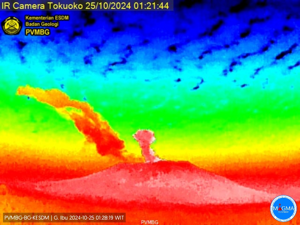
Indonesia , Ibu :
An eruption of Mount Ibu occurred on Thursday, 24 October 2024 at 06:58 UTC (15:58 local time) with the height of the ash column observed at ±500 m above the summit (5840 FT (1825 M) m above sea level). The ash column was grey in colour with a thick intensity, oriented towards the North-East. This eruption was recorded on a seismograph with a maximum amplitude of 28 mm and a duration of 58 seconds.
VOLCANO OBSERVATORY NOTICE FOR AVIATION – VONA
Issued : October 24 , 2024
Volcano : Ibu (268030)
Current Aviation Colour Code : ORANGE
Previous Aviation Colour Code : orange
Source : Ibu Volcano Observatory
Notice Number : 2024IBU956
Volcano Location : N 01 deg 29 min 17 sec E 127 deg 37 min 48 sec
Area : North Maluku, Indonesia
Summit Elevation : 4240 FT (1325 M)
Volcanic Activity Summary :
Eruption with volcanic ash cloud at 06h58 UTC (15h58 local).
Volcanic Cloud Height :
Best estimate of ash-cloud top is around 5840 FT (1825 M) above sea level or 1600 FT (500 M) above summit. May be higher than what can be observed clearly. Source of height data: ground observer.
Other Volcanic Cloud Information :
Ash cloud moving to northeast. Volcanic ash is observed to be gray. The intensity of volcanic ash is observed to be thick.
Remarks :
Eruption recorded on seismogram with maximum amplitude 28 mm and maximum duration 58 second.
Source et photo : Magma Indonésie .
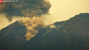
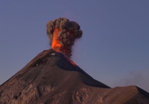
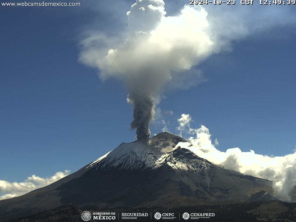
Mexico , Popocatepetl :
October 24, 11:00 (October 24, 17:00 GMT), Activity of the last 24 hours
45 exhalations were detected, accompanied by water vapor, volcanic gases and ash. In addition, 908 minutes of high-frequency, low-amplitude tremors were recorded.
The National Center for Communication and Operation of Civil Protection (Cenacom) reported light ash falls in Ocuituco, Tetela del Volcán and Yecapixtla, in the state of Morelos.
During the morning and at the time of this report, a continuous emission of water vapor, volcanic gases and ash is observed with dispersion towards the North (N).
The Popocatépetl volcanic alert fire is in yellow phase 2.
The scenarios anticipated for this phase are:
A few small to moderate explosions
Occurrence of tremors of varying amplitude
Light to moderate ash rains in the surrounding towns and in some more distant towns
Ejection of incandescent fragments within the 12-kilometer exclusion radius
The occurrence of lahars can be expected to descend into the ravines, due to the accumulation of ash on the slopes and its interaction with the rains expected in the coming weeks.
Possibility of pyroclastic flows not reaching the populations
Source et photo : Cenapred.
Colombia , Nevado del Ruiz :
Manizales, October 22, 2024, 9:50 p.m.
From the monitoring of the activity of the Nevado del Ruiz volcano, the Colombian Geological Survey (SGC), an entity attached to the Ministry of Mines and Energy, reports that:
During the week of October 15 to 21, 2024, the volcano continued with unstable behavior. Compared to the previous week, the main variations in the monitored parameters were:
– Seismicity related to the activity of fluids inside volcanic conduits increased in the number of earthquakes recorded and in the seismic energy released, especially from seismic signals related to pulsatile ash emissions. These types of signals were notoriously accompanied by several small earthquakes that occurred after their recording. The signal energy levels ranged from low to moderate. Some of the seismic events recorded were associated with ash emissions and temperature changes in the emitted materials. Both phenomena were confirmed by the cameras (conventional or thermographic) used to monitor the volcano and by the reports received from the managers of the Los Nevados National Natural Park (PNNN) and the inhabitants of the area of influence. The greatest temperature change of the week was recorded on October 16 and was associated with the emission of ash at 04:52, which stands out for being one of the four highest values observed so far this year.

– Seismic activity associated with rock fracturing inside the volcanic edifice maintained similar levels in the number of earthquakes recorded and in the seismic energy released. The earthquakes were located mainly in the Arenas crater, on the north-northwest flank and scattered on the other flanks, at smaller distances of up to 11 km from the crater. The depths of the events varied between less than 1 km and 8 km from the summit of the volcano. The highest magnitude of the week was 1.0, corresponding to the earthquake recorded on October 20 at 17:25 . In addition, the recording of seismicity related to the activity of the lava dome (protuberance or mound) located at the bottom of the crater increased with low energy levels.
– The emission of water vapour and gas into the atmosphere from the Arenas crater continued. The rates of degassing of sulphur dioxide (SO2) were variable and showed a slight decrease compared to the previous week. This decrease is due to the fact that on several occasions the wind direction did not favour the location of the measuring stations.
– The maximum height of the gas column was 1300 m vertically and 2200 m in dispersion; these values were measured above the volcanic summit during the ash emissions of 16 October at 04:52 and 19 October at 16:37 respectively. The direction of dispersion of the columns was variable with a tendency mainly towards the northwest of the volcano and, to a lesser extent, towards the northeast, north-northeast and northwest of it. These directions caused ash falls in the sectors of Brisas and Aguacerales (in the PNNN area) and in the sector of Recreo (departments of Caldas and Tolima).

– When monitoring thermal anomalies at the bottom of the Arenas crater, from satellite monitoring platforms and despite the atmospheric conditions of high cloudiness in the area, some reports of low and moderate energy level anomalies were obtained.
and moderate.
Source : SGC
Photos : SGC , Carlos Ortega.
La Martinique , Montagne Pelée :
Weekly report, Institut de physique du globe de Paris / Observatoire volcanologique et seismologique de Martinique
Saint-Pierre, October 18, 2024 at 3:00 p.m. local time (GMT-4)
Volcanic activity remains low this week with 3 earthquakes of volcanic origin observed.
Between October 11, 2024 at 4:00 p.m. (UT) and October 18, 2024 at 4:00 p.m. (UT), the OVSM recorded 3 low-energy volcano-tectonic earthquakes. These earthquakes were clearly identified as coming from one of the well-known seismically active zones at Mount Pelée, located between 1.0 and 1.4 km deep below the summit of the volcano. The superficial volcano-tectonic seismicity is associated with micro-fracturing in the volcanic edifice linked to the global reactivation of the volcano observed since the end of 2018.
No earthquake was felt by the population.
The previous week, the OVSM had recorded 10 earthquakes of volcanic origin. As of October 18, 2024 and during the last 4 weeks, the OVSM has therefore observed a total of 50 volcanic earthquakes, or an average of 12 to 13 earthquakes per week.
During the volcanic reactivation phases of volcanoes similar to Mount Pelée, it is usual to observe seismic activity that varies in intensity and frequency.
For more details on observations and interpretations of volcanic activity over the longer term, refer to the OVSM monthly bulletins.
The alert level is currently YELLOW: vigilance.
Source : Direction de l’OVSM-IPGP.
Photo : Ville-Saintemarie