October 23 , 2024.
Italy , Stromboli :
WEEKLY BULLETIN, from October 14, 2024 to October 20, 2024. (issue date October 22, 2024)
SUMMARY STATUS OF ACTIVITY
In light of the monitoring data, it emerges:
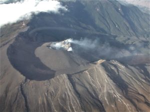
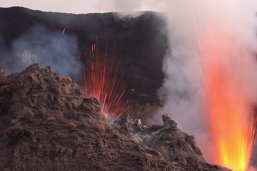
1) VOLCANOLOGICAL OBSERVATIONS: During this period, intense eruptive activity with splashes was observed from the northern area of the crater. The total hourly frequency was oscillating between average values (9-15 events/h). The intensity of the explosions was low in the northern crater area and medium to high in the central-southern area
2) SEISMOLOGY: The seismological parameters monitored do not show significant variations, with the exception of the landslide event recorded on 10/19.
3) GROUND DEFORMATIONS: A variation of the order of 1.4 microRad was measured at the inclinometer station of Timpone del Fuoco on 19 October 2024. This variation is probably
due to heavy rains.
4) GEOCHEMISTRY: SO2 fluxes of medium-high and increasing level
CO2 fluxes from the ground, there are no updates
The CO2/SO2 ratio in the plume oscillates between medium and high values during the week.
The helium isotope ratio in the thermal aquifer is at the average values (R/Ra = 4.34) given on 29/09/2024
CO2 fluxes in Mofeta, in the San Bartolo area: shows a slight upward trend, reaching high values.
CO2 flow in Scari: stable values around 160 g/m2/day.
5) SATELLITE OBSERVATIONS: Thermal activity observed by satellite in the summit area was generally low to moderate.
VOLCANOLOGICAL OBSERVATIONS
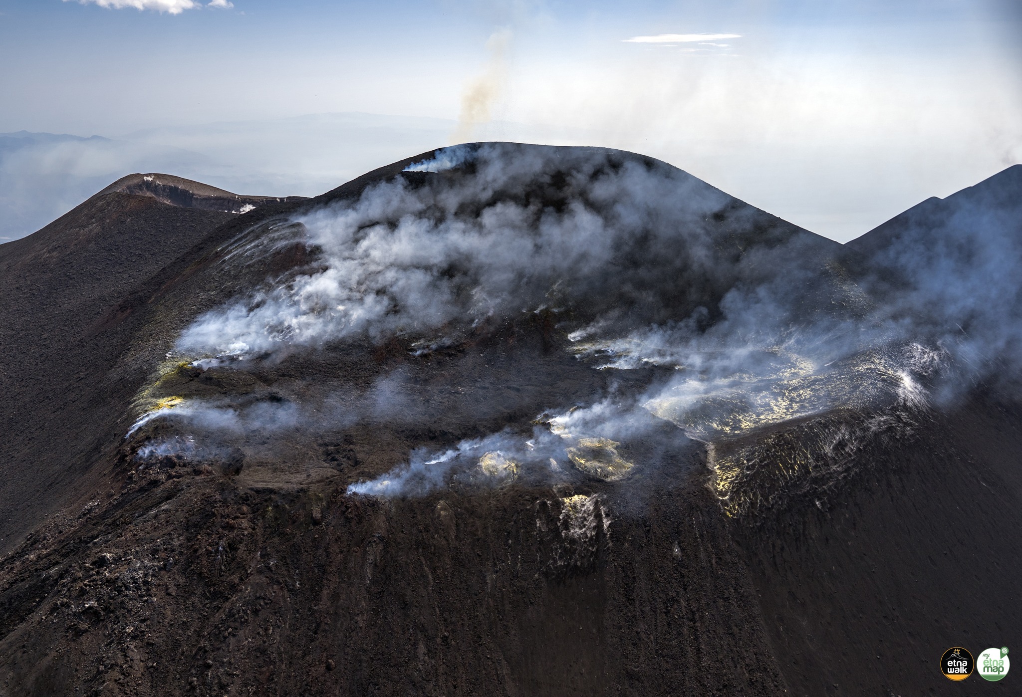
During the observed period, the eruptive activity of Stromboli was characterized through the analysis of images recorded by the INGV-OE surveillance cameras located at an altitude of 190 m (SCT-SCV) and at Punta dei Corvi (SPCT). The explosive activity was mainly produced by 4 (four) eruptive vents located in the northern area of the crater and by 2 (two) vents located in the central southern area.
Observations of the explosive activity captured by the surveillance cameras
In the area of the northern crater (N), four active vents were observed that produced explosive activity of low intensity (less than 80 m in height) and sometimes medium (less than 150 m in height).
Furthermore, projections were observed, sometimes intense on 15 and 20 October. The products emitted were mainly coarse materials (bombs and lapilli). The average frequency of explosions ranged from 9 to 16 events/h.
In the Centre-South (CS) area, explosive activity was sporadic and produced by at least two vents, explosions were of variable intensity from medium (less than 150 m in height) to high (more than 250 m in height) emitting fine materials mixed with coarse materials.
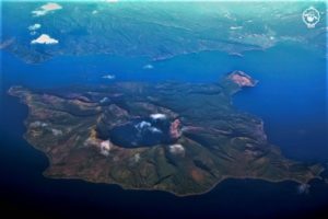
Images acquired on 16 October in the summit area. a) The crater terrace seen from Pizzo sopra La Fossa; the Centre-South (CS) crater area appears as a single, wide and deep depression, while the North crater area is recognizable by the plume of the N2 vent and the most summital part of the N1 cone.
Field observations of 16 October 2024
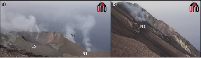
On 16 October, an inspection was carried out in the summit area between days 10 and 13 by INGV staff as part of the UN Departmental Project activities. From Pizzo sopra La Fossa, a wide and deep depression was visible near the Centre-South crater area, inside which there were at least 2 vents in an almost central position, easily recognizable thanks to the continuous degassing, and a third mouth facing the wall, facing the Pizzo. From these vents, a single but intense emission of ash was observed up to a height of over 300 m, accompanied by a minor production of blocks and followed by an emission of ash also from the other 2 vents. Sometimes, modest collapses occurred from the internal sub-vertical walls of the depression. The eruptive activity near the area of the North crater, whose visibility was largely covered by the Pizzo, was observed from the Roccette shelters, hence the presence of a cone (N1) with frequent projection activity interspersed with Strombolian explosions of medium intensity. At the level of cone N2, there was a strong degassing associated with strong explosions and episodic explosions of low intensity.
Source : INGV
Photos : Stromboli stati d’animo / Sebastiano Cannavo , INGV / Uno , Capture d’écran 23 / 10 /2024
Italy / Sicily , Etna :
WEEKLY BULLETIN, from October 14, 2024 to October 20, 2024. (issue date October 22, 2024)
SUMMARY STATUS OF ACTIVITY
In light of monitoring data, it is clear that:
1) VOLCANOLOGICAL OBSERVATIONS: Continuous intra-crater explosive activity at the Northeast Crater, sporadic light ash emissions from the Southeast Crater, and degassing activity at the summit craters.
2) SEISMOLOGY: Low seismic activity due to fracturing; volcanic tremor amplitude remained mainly at medium levels.
3) INFRASOUND: Moderate infrasound activity.
4) GROUND DEFORMATIONS: Ground deformation monitoring networks have not recorded significant variations
5) GEOCHEMISTRY: SO2 flux at an average and decreasing level
The CO2 flux from the soil is at average values.
The partial pressure of dissolved CO2 in groundwater has values within the seasonal variability.
The Helium isotope ratio in peripheral sites decreases but remains at high values.
6) SATELLITE OBSERVATIONS: The thermal activity observed by satellite in the summit area was generally low with some isolated thermal anomalies of moderate level.
VOLCANOLOGICAL OBSERVATIONS
During the week, the monitoring of the volcanic activity of Etna was carried out through the analysis of the images of the surveillance cameras of the INGV – Osservatorio Etneo (INGV-OE). Between 17 and 20 October, the observations were very discontinuous due to unfavourable weather conditions.
In general, during the observation period, Etna was characterised by degassing activity of varying intensity from all the summit craters, by intra-crater explosive activity at the North-East Crater (CNE) and by ash emissions from the South-East Crater (CSE).
In particular, during the observation week, Etna’s activity was mainly supported by the North-East Crater (CNE), which continued to feed persistent intra-crater explosive activity. This activity produced isolated ash emissions that rapidly dispersed in the summit area, products that in some cases spilled out of the crater rim, and continuous lightning during the night.
Sporadic and light ash emissions, sometimes very diluted, were also observed from the Southeast Crater (SEC), especially at the beginning of the week. In this case too, the ash rapidly dispersed near the summit area.
Source : INGV
Photo : Etna Walk/ Giuseppe Distefano ( 03/08/2024)
Kamchatka , Sheveluch :
VOLCANO OBSERVATORY NOTICE FOR AVIATION (VONA)
Issued: October 23 , 2024
Volcano: Sheveluch (CAVW #300270)
Current aviation colour code: ORANGE
Previous aviation colour code: orange
Source: KVERT
Notice Number: 2024-89
Volcano Location: N 56 deg 38 min E 161 deg 18 min
Area: Kamchatka, Russia
Summit Elevation: 3283 m (10768.24 ft), the dome elevation ~2500 m (8200 ft)
Volcanic Activity Summary:
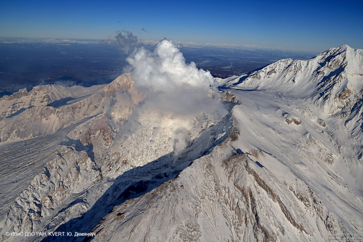
Video and satellite data by KVERT shows a strong wind lifts ash from the southern slopes of Sheveluch volcano, and a plume of resuspended ash is extending about 60 km to the east-southeast of the volcano.
An extrusive-effusive eruption of the Sheveluch volcano continues. The danger of ash explosions up to 10 km (32,800 ft) a.s.l. remains. Ongoing activity could affect international and low-flying aircraft.
Volcanic cloud height:
3000 m (9840 ft) AMSL Time and method of ash plume/cloud height determination: 20241023/0540Z – Himawari-9 14m15
Other volcanic cloud information:
Distance of ash plume/cloud of the volcano: 60 km (37 mi)
Direction of drift of ash plume/cloud of the volcano: ESE / azimuth 114 deg
Time and method of ash plume/cloud determination: 20241023/0540Z – Himawari-9 14m15
Remarks:
an resuspended ash
Source : Kvert
Photo : Yu. Demyanchuk. IVS FEB RAS, KVERT ( 11/2023)
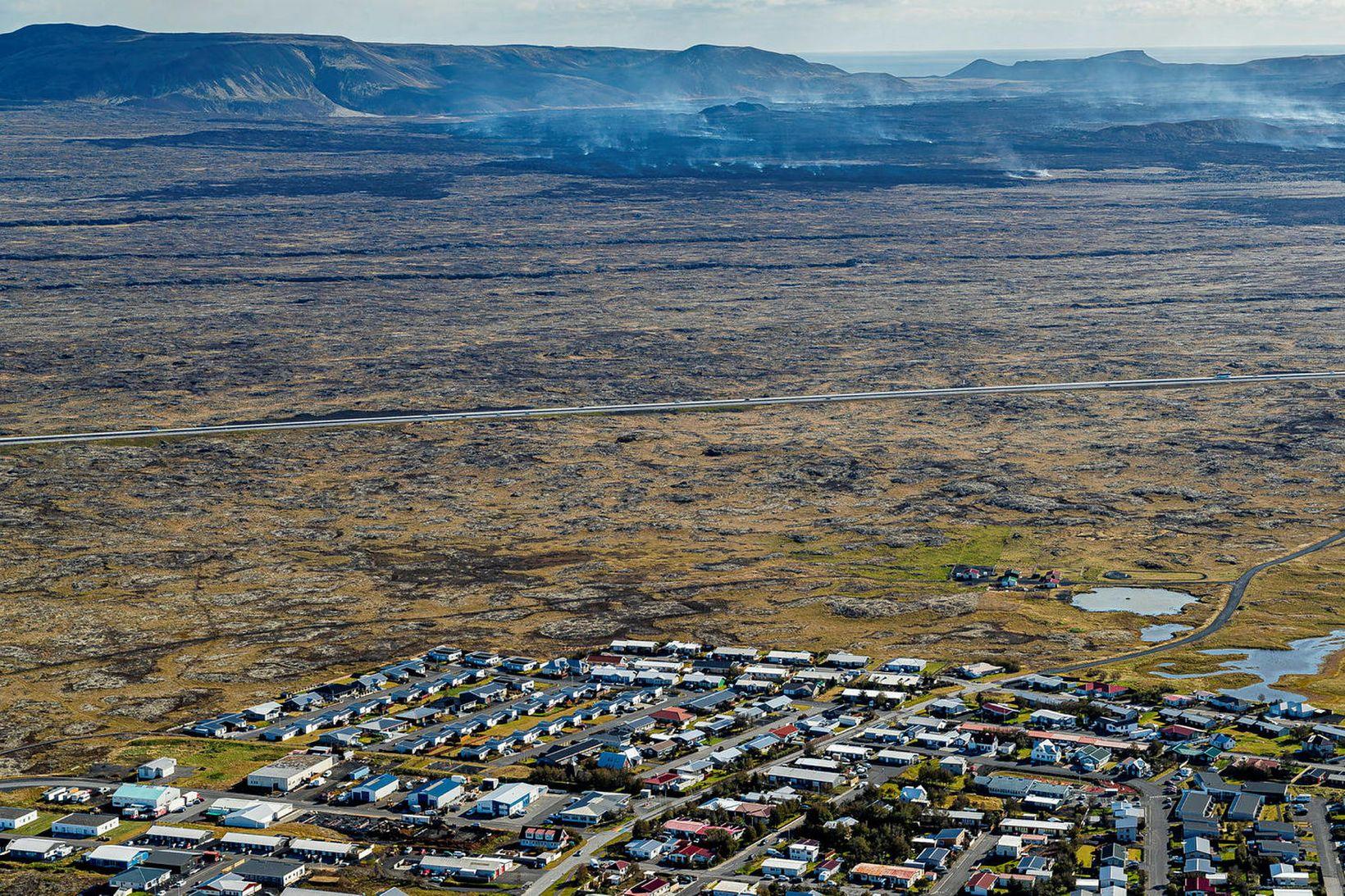
Iceland , Reykjanes Peninsula :
Magma accumulation beneath and land uplift above Svartsengi continue
Models reveal that the volume of magma is now approximately two-thirds of what accumulated before the last eruption on August 22
Updated 22. October at 15:30 UTC
GPS measurements and model calculations in the Svartsengi area show that ground uplift and magma accumulation continue.
If the current rate of magma accumulation in the reservoir continues, the lower uncertainty threshold for the volume of magma that might culminate in a dike intrusion or eruption will be reached in early November.
The current hazard assessment remains in effect until October 29, barring any changes.
Ground uplift and magma accumulation beneath Svartsengi are progressing at a rate consistent with recent weeks. Seismic activity has slightly increased in recent days, with around five earthquakes per day occurring along the dyke. The largest earthquake had a magnitude of 1.5.
Model calculations based on GPS data indicate that the volume of magma that has accumulated beneath Svartsengi is now approximately two-thirds of what it was before the previous eruption, which began on August 22.
If magma inflow continues at a similar rate, the lower uncertainty threshold that might feed a new intrusion or eruption is expected to be reached in early November. If a significant increase in seismic activity is detected around the same time, it could suggest that the likelihood of a new magma intrusion and a potential eruption is increasing. This likelihood will gradually rise as more magma accumulates and seismic activity intensifies.
Volume estimated through model calculations
The volume of magma that has accumulated beneath Svartsengi since the last eruption ended is estimated to be 14 million cubic meters, according to model calculations. It is estimated that around 24 million cubic meters of magma exited the magma chamber during the last eruption, which began on August 22 and was the largest eruption in this sequence of events. The uncertainty in these calculations is approximately +/- 5 million cubic meters. The volume of magma beneath Svartsengi is therefore projected to reach a value that is comparable to what it was before the last eruption when it enters within the range defined by the « lower uncertainty limit » (19 million cubic meters) and the « upper uncertainty limit » (29 million cubic meters).
The models, which are based on GPS data and are updated daily, indicate how much magma has accumulated since the last magma intrusion, providing an estimation of when the uncertainty thresholds may be reached. These models are based on the estimated inflow of magma into the reservoir beneath Svartsengi, and small changes in that flow can affect the final assessment. It is difficult to determine how far beyond these previously observed limits the magma volume can increase before an eruption starts. The trend has shown that the time between eruptions is increasing, as the volume of magma required to trigger the next magma intrusion or eruption appears to be increasing over time. It is possible that the risk of an eruption may be assessed to be high for some time before an event begins.
Source : IMO
Photo : mbl .is / Árni Sæberg.
Colombia , Puracé – Chaîne volcanique Los Coconucos :
Popayán, October 22, 2024, 3:30 p.m.
From the monitoring of the activity of the Puracé volcano – Los Coconucos volcanic chain, the Colombian Geological Survey (SGC), an entity attached to the Ministry of Mines and Energy, reports that:
During the week of October 15 to 21, seismic activity continued to record a significant number of events, mainly related to the transit of fluids under the volcano. This seismicity presented low energy levels similar to those observed in previous weeks, located under the building of the Puracé volcano, with depths of less than 1 km. The seismicity related to rock fracturing (type VT) did not show notable magnitudes and was concentrated mainly near the crater of the Puracé volcano, as well as below the Piocollo volcano, with depths of up to 3 km.
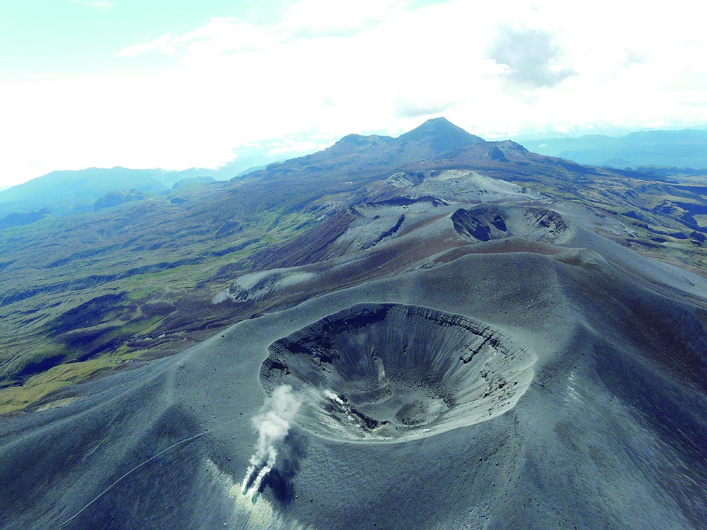
In addition, the slow deformation process that began in April 2022 on the Puracé volcano continued to be recorded. On the other hand, the monitoring of volcanic gases, electromagnetic fields and acoustic sensors did not show significant variations. Regarding the images captured by the installed cameras, it was observed that high degassing was maintained in the lateral fumarole.
Based on the above, the SGC recommends carefully monitoring the evolution of volcanic activity through weekly bulletins and other information published in the
official channels, as well as complying with the instructions of local and departmental authorities and the National Disaster Risk Management Unit (UNGRD).
The alert status for volcanic activity remains in yellow alert status: active volcano with changes in the behavior of the base level of the monitored parameters and other manifestations.
Source et photo : SGC