October 02 , 2024.
Italy / Sicily , Etna :
WEEKLY BULLETIN, from October 23, 2024 to October 29, 2024. (issue date September 01, 2024)
SUMMARY STATUS OF ACTIVITY
In light of the monitoring data, it emerges:
1) VOLCANOLOGICAL OBSERVATIONS: Degassing activity at the summit craters and intra-crater explosive activity at the Northeast crater.
2) SEISMOLOGY: Low seismic activity due to fracturing. Average amplitude of volcanic tremor at a rather average level over the first 5 days of the week. In the following days, the amplitude of the tremor oscillated between average and high values.
3) INFRASOUND: Modest infrasound activity.
4) GROUND DEFORMATIONS: Over the past week, ground deformation monitoring networks have not recorded significant changes
5) GEOCHEMISTRY: SO2 flux at an average and decreasing level
The soil CO2 flux is at average values.
The partial pressure of dissolved CO2 in groundwater shows values within seasonal variability
Isotope ratio: No update available.
6) SATELLITE OBSERVATIONS: The thermal activity observed by satellite in the summit area was generally low to moderate.
VOLCANOLOGICAL OBSERVATIONS
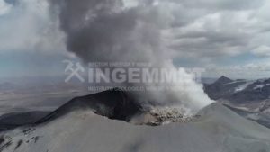
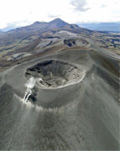
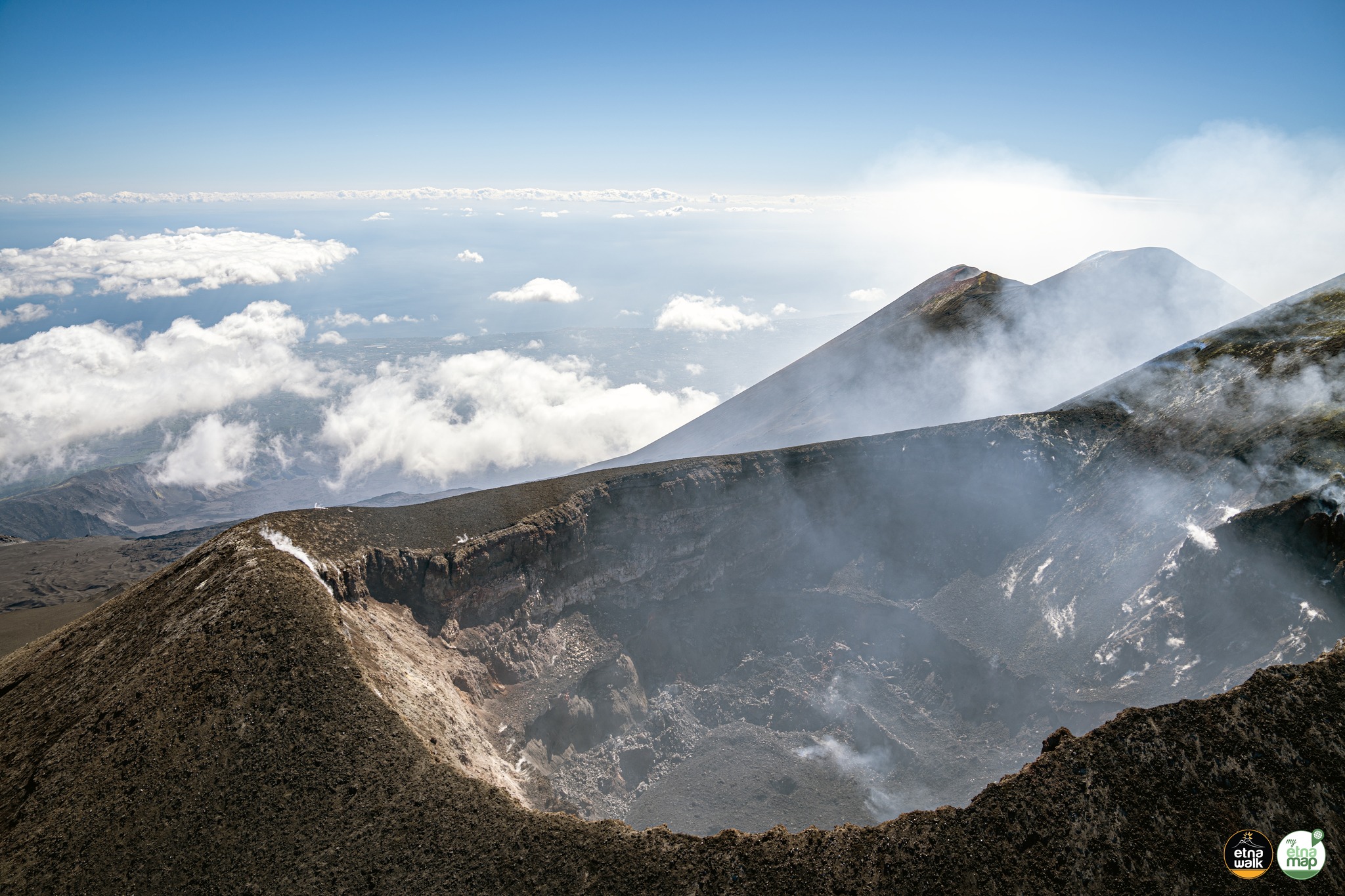
During the week, the monitoring of the volcanic activity of Etna was carried out through the analysis of images from the surveillance camera network of the National Institute of Geophysics and Volcanology, Osservatorio Etneo (INGV-OE). During the period under review, the activity was a continuous degassing of variable intensity affecting all the summit craters. In particular on September 23, from 21:00 UTC, an intra-crater explosive activity was observed on the surveillance cameras of the Northeast Crater (CNE). The phenomenon is still present but with less frequency.
SEISMOLOGY
Seismicity: During the week in question, 3 seismic events of magnitude equal to or greater than 2 were recorded. The first 2 events (Mlmax=2.4), recorded on 23 and 24 September, were located on the south-eastern slope of the volcano at a depth between 4 and 7 km . The third event (25 September, Ml=2.2) is located 2.7 km southwest of Randazzo (CT) at a depth of about 30 km .
Volcanic tremor: The average amplitude of volcanic tremor during the first 5 days of the week remained confined within the range of average values . From about 20:00 UTC on 27 September, a progressive increase was observed, with oscillations from the average value to the high value. In particular, the average amplitude of volcanic tremor reached its maximum value around 00:20 UTC on 29 September . The centroid of the tremor sources is mainly located in an area between the Bocca Nuova crater and the Northeast crater at depths between 2,500 and 3,000 meters above mean sea level.
Source : INGV
Photo : Etna Walk / Giuseppe Distefano ( FDB 3/09/2024)
Italy , Stromboli :
WEEKLY BULLETIN, from October 23, 2024 to October 29, 2024. (issue date September 01, 2024)
SUMMARY STATUS OF ACTIVITY
In light of the monitoring data, it emerges:
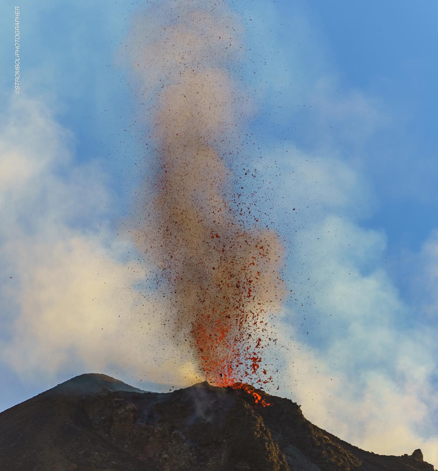
1) VOLCANOLOGICAL OBSERVATIONS: During this period, intense eruptive activity with splashes was observed in the northern area of the crater. The total hourly frequency of explosions fluctuated between low (4 events/hour) and medium (15 events/hour) values. The intensity of the explosions was low in the northern crater area and medium to high in the central southern area.
2) SEISMOLOGY: The monitored seismological parameters do not show significant variations.
3) GROUND DEFORMATIONS: The island’s ground deformation monitoring networks did not show any significant changes to report for the period under review.
4) GEOCHEMISTRY: SO2 flux at medium and increasing level
The CO2 flux from the ground in the STR02 summit area is at medium values.
The CO2/SO2 ratio in the plume is decreasing to medium values.
There is no update of the helium isotope ratio in the thermal aquifer.
CO2 flux at Mofeta in the San Bartolo area: close to the threshold of high values.
CO2 flux at Scari: there are no updates due to technical problems.
5) SATELLITE OBSERVATIONS: The thermal activity observed by satellite in the summit area was generally low.
VOLCANOLOGICAL OBSERVATIONS
During the observed period, the eruptive activity of Stromboli was characterized by analyzing the images recorded by the INGV-OE surveillance cameras located at an altitude of 190 m (SCT-SCV) and at Punta dei Corvi (SPCT). The explosive activity was mainly produced by two eruptive vents located in the North crater area and by two vents located in the Centre-South crater area.
Observations of the explosive activity captured by the surveillance cameras
In correspondence with the North (N) crater area, two active vents were observed that produced low-intensity explosive activity (the eruption products reached a height of less than 80 m). In addition, splashes were observed, sometimes intense, on 23 and 26 September. The products emitted in the eruption were mainly coarse materials (bombs and lapilli). The average frequency of explosions ranged from 3 to 15 events/hour.
In the area of the Centre-South (CS) crater, explosive activity was produced by at least two vents, mainly between 26 and 28 September; the explosions were of variable intensity ranging from medium (height less than 150 m) to high (height greater than 250 m) emitting fine materials sometimes mixed with coarse ones. The average frequency of explosions ranged from 1 to 5 events/hour
Source : INGV
Photo : Stromboli stati d’animo / Sebastiano Cannavo.
United-States , Yellowstone :
Tuesday, October 1, 2024, 1:57 PM MDT (Tuesday, October 1, 2024, 19:57 UTC)
44°25’48 » N 110°40’12 » W,
Summit Elevation 9203 ft (2805 m)
Current Volcano Alert Level: NORMAL
Current Aviation Color Code: GREEN
Summary
Yellowstone Caldera activity remains at background levels, with 54 located earthquakes in September (maximum = M2.2). Deformation measurements indicate a pause in subsidence (which has been ongoing since 2015) due to seasonal changes in snowmelt and groundwater conditions.
Recent Work and News
Steamboat Geyser did not erupt during September, but nearly continuous minor activity suggests that an eruption is likely in the coming days to weeks.
Yellowstone Volcano Observatory scientists conducted field work during September that included maintenance of permanent geophysical, gas, and temperature-monitoring stations, deployment and maintenance of temporary seismic nodes and other geophysical equipment around Black Diamond Pool (site of a hydrothermal explosion on July 23, 2024), and collection of water and gas samples from various sites around Yellowstone National Park.
Seismicity
During September 2024, the University of Utah Seismograph Stations, responsible for the operation and analysis of the Yellowstone Seismic Network, located 54 earthquakes in the Yellowstone National Park region. The largest event of the month was a micro earthquake of magnitude 2.2 located about 5 miles west of West Thumb in Yellowstone National Park on September 1 at 5:09 AM UTC (August 31 at 11:09 PM MDT).
There were no swarms identified during the month of September.
Yellowstone earthquake activity is currently at background levels.
Ground Deformation
Since June, continuous GPS stations in Yellowstone Caldera and near Norris Geyser Basin have recorded about 1 cm (0.4 in) of uplift. This deformation occurs every summer and is caused by seasonal changes related to snowmelt and groundwater conditions throughout the region. Since 2015, Yellowstone Caldera has been subsiding at a rate of about 3 cm (1.2 in) per year, interrupted each summer by a seasonal summertime pause or slight uplift.
Source : YVO
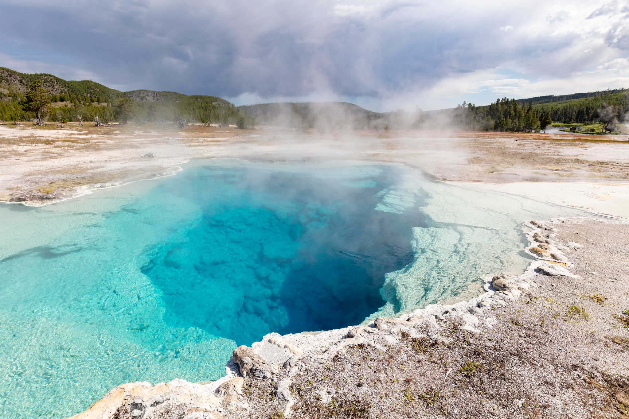
Photo : sapphire pool / National Park Service / Jacob W. Frank, July 20, 2020.
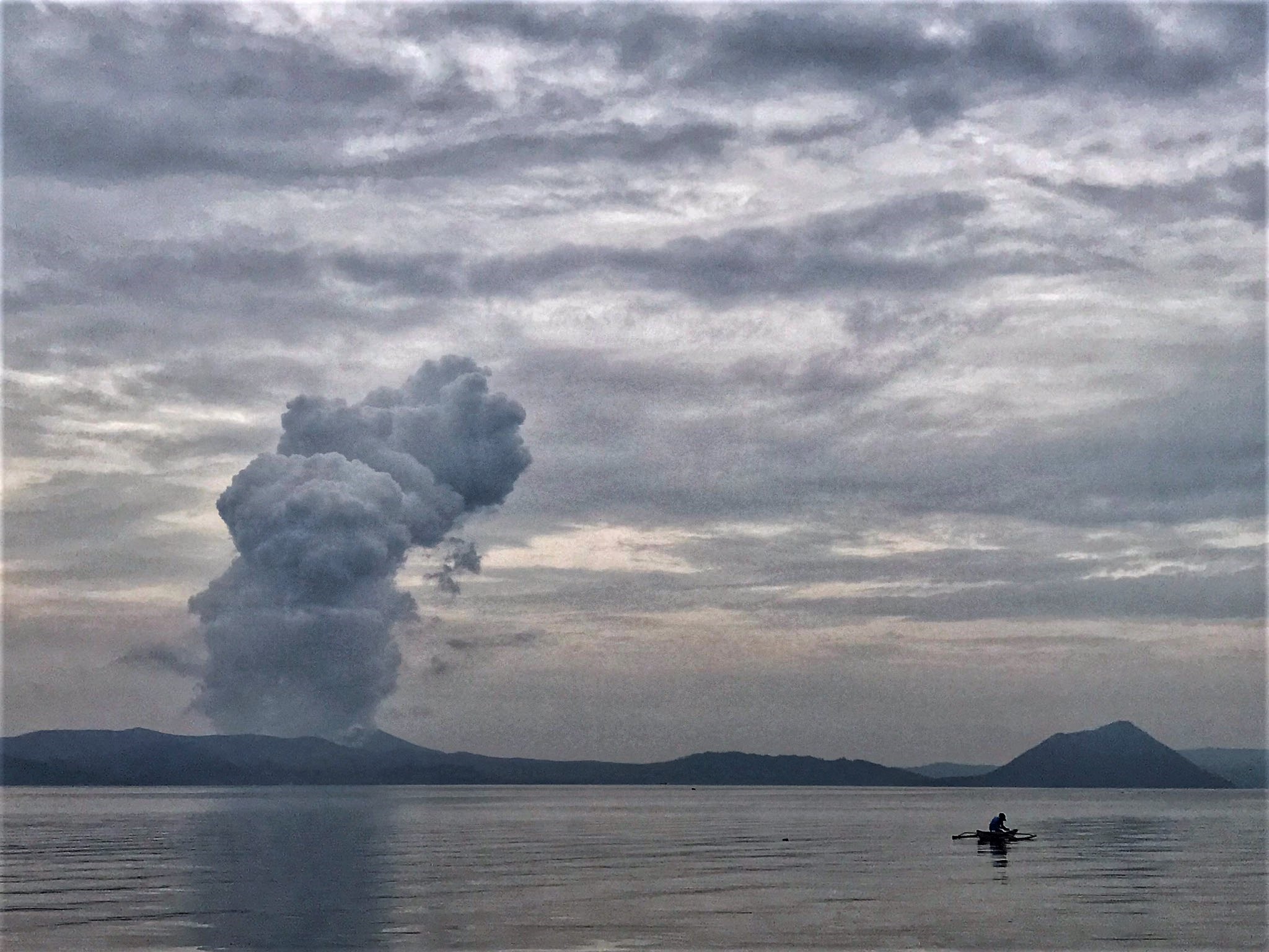
Philippines , Taal :
TAAL VOLCANO ADVISORY , 1 October 2024 , 6:50 PM
Notice of weak phreatic activity at Taal Volcano.
Five (5) weak phreatic or steam-driven events at the Taal Main Crater occurred today, 01 October 2024, between 01:10 AM and 04:37 PM and lasted between two (2) to six (6) minutes based on visual, seismic and infrasound records of the Taal Volcano Network (TVN). The events produced steam-laden plumes that rose 300 to 2100 meters above the Main Crater before drifting east-northeast based on IP camera monitors. A total of seventeen (17) of these events have been recorded since 22 September 2024. Meanwhile, sulfur dioxide (SO2) emissions averaged 1,354 tonnes/day on 30 September 2024. Nonetheless, average SO2 emissions since January this year remain high at 6,760 tonnes/day. Weak phreatic activity is likely driven by the continued emission of hot volcanic gases at the Taal Main Crater and could be succeeded by similar events. The background levels of volcanic earthquake activity and ground deformation detected at Taal indicate that unrest is unlikely to progress into magmatic eruption.
DOST-PHIVOLCS reminds the public that Alert Level 1 prevails over Taal Volcano, which means that it is still in abnormal condition and should not be interpreted to have ceased unrest nor ceased the threat of eruptive activity. At Alert Level 1, sudden steam-driven or phreatic explosions, volcanic earthquakes, minor ashfall and lethal accumulations or expulsions of volcanic gas can occur and threaten areas within the Taal Volcano Island (TVI). Furthermore, degassing of high concentrations of volcanic SO2 continues to pose the threat of potential long-term health impacts to communities around Taal Caldera that are frequently exposed to volcanic gas. DOST-PHIVOLCS strongly recommends that entry into TVI, Taal’s Permanent Danger Zone or PDZ, especially the vicinities of the Main Crater and the Daang Kastila fissure, must remain strictly prohibited. Local government units are advised to continuously monitor and assess preparedness of their communities and undertake appropriate response measures to mitigate hazards that could be posed by long-term degassing and related phreatic activity. Civil aviation authorities must advise pilots to avoid flying close to the volcano as airborne ash and ballistic fragments from sudden explosions and wind-remobilized ash may pose hazards to aircrafts.
DOST-PHIVOLCS is closely monitoring Taal Volcano’s activity and any new significant development will be immediately communicated to all stakeholders.
Source : Phivolcs
Photo : Rizal M ( 07/2021)
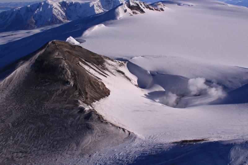
Alaska , Wrangell :
AVO/USGS Volcanic Activity Notice
Current Volcano Alert Level: NORMAL
Previous Volcano Alert Level: UNASSIGNED
Current Aviation Color Code: GREEN
Previous Aviation Color Code: UNASSIGNED
Issued: Tuesday, October 1, 2024, 10:04 AM AKDT
Source: Alaska Volcano Observatory
Notice Number: 2024/A659
Location: N 62 deg W 144 deg 1 min
Elevation: 14163 ft (4317 m)
Area: Wrangell Volcanic Field
Volcanic Activity Summary:
Field crews from the Alaska Volcano Observatory (AVO) have completed work on seismic monitoring equipment at Mt. Wrangell, bringing enough local stations back online to locate small volcanic earthquakes and detect potential activity above background at the volcano. As a result, the Aviation Color Code and Volcano Alert Level for Mt. Wrangell are being changed from UNASSIGNED to GREEN/NORMAL.
Remarks:
Mt. Wrangell is a 4317 m (14,163 ft) high, andesitic, shield volcano with an ice-filled summit caldera, located in the Wrangell-St. Elias National Park and Preserve. Mt. Wrangell has three small post-caldera craters, named North Crater, East Crater, and Mt. Zanetti. These craters are all geothermally active, and there are frequent historical reports of steam from Mt. Wrangell. There are also several questionable reports of historical eruptive activity. Mt. Wrangell is 330 km (206 mi) northeast of Anchorage.
Source : AVO
Photo : Paul Claus ( 27 octobre 2016 )