September 30 , 2024.
New Zealand , White Island :
Eruption may be declining at Whakaari/White Island but gas and ash emissions remain variable. Volcanic Alert Level remains at Level 3 and Aviation Colour Code at Orange.
Published: Mon Sep 30 2024 3:00 PM
Observations from an overflight, images from GeoNet cameras and satellite imagery combined, suggest that minor eruptive activity Whakaari/White Island may be declining. Minor ash emission does continue but seemingly at lower levels than in the past few weeks.
Observations from an observation flight on 24 September 2024 suggest the level of activity from the vent area has decreased. The volcanic ash emissions are now less constant and less vigorous overall. Ash is still being detected occasionally by Metservice but less frequently, and possibly mostly when the wind conditions cause the ash to accumulate in the air locally, near the island. The height of the ash plume sometimes reaches to 1 km above the island. As per the previous weeks, any ashfall on the ground remains confined to the island or near proximity. The likelihood of ash fallout on the mainland remains very low. With clear views, GeoNet cameras at Whakatāne and Te Kaha continue to record volcanic plumes.
These observations are consistent with ongoing volcanic activity, now in a less vigorous state. Minor eruptive activity does continue. The Volcanic Alert Level remains at Level 3 (minor eruption) and the Aviation Colour Code remains at Orange.

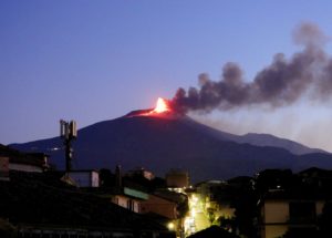
Images of the gas and ash plume at Whakaari/White Island on 24 September (B. Scott) Ash fall from the plume was only noted near the island.
Our observations and data indicate a decline in eruption activity has occurred over the last 7 days. Emission of volcanic gases with small amounts of ash continues and is variable through time. With changing wind directions, MetService advise us and the aviation industry that there is sometimes a chance that the plume will be blown towards the Bay of Plenty and East Cape coast. The level of volcanic activity could escalate back to levels seen over the last 4 –5 weeks, although this likelihood is low.
GNS Science’s Volcano Monitoring Group and National Geohazards Monitoring Centre will continue to closely monitor volcanic activity at Whakaari with remote cameras, satellite imagery, and regular monitoring flights. We will provide updates when information becomes available.
Source : Geonet / Brad Scott / Duty Volcanologist
Photos : Geonet, Brad Scott.
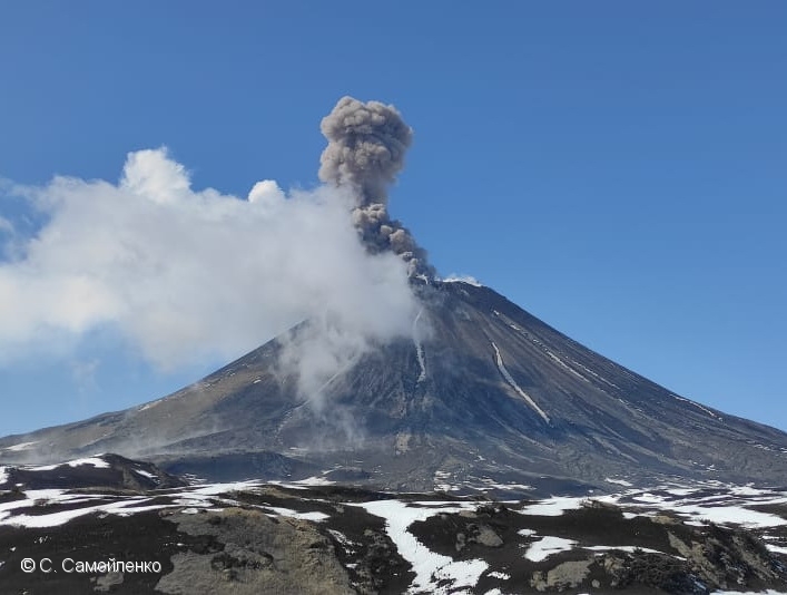
Kamchatka , Karymsky :
VOLCANO OBSERVATORY NOTICE FOR AVIATION (VONA)
Issued: September 30 , 2024
Volcano: Karymsky (CAVW #300130)
Current aviation colour code: ORANGE
Previous aviation colour code: orange
Source: KVERT
Notice Number: 2024-78
Volcano Location: N 54 deg 2 min E 159 deg 26 min
Area: Kamchatka, Russia
Summit Elevation: 1486 m (4874.08 ft)
Volcanic Activity Summary:
Satellite data by KVERT shows a strong wind lifts ash from the eastern slopes of Karymsky volcano, and a plume of resuspended ash is extending about 200 km to the east-southeast of the volcano.
A moderate activity of the volcano continues. Ash explosions up to 10 km (32,800 ft) a.s.l. could occur at any time. Ongoing activity could affect international and low-flying aircraft.
Volcanic cloud height:
1500-2000 m (4920-6560 ft) AMSL Time and method of ash plume/cloud height determination: 20240930/0430Z – Himawari-9 14m15
Other volcanic cloud information:
Distance of ash plume/cloud of the volcano: 200 km (124 mi)
Direction of drift of ash plume/cloud of the volcano: ESE / azimuth 103 deg
Time and method of ash plume/cloud determination: 20240930/0430Z – Himawari-9 14m15
Source : Kvert
Photo : S. Samoylenko ( 05/2022) .
Indonesia , Lewotobi Laki-laki :
An eruption of Lewotobi Laki occurred on Saturday, September 28, 2024 at 14:07 WITA with the height of the ash column observed at ± 800 m above the summit (± 2384 m above sea level). The ash column was observed to be gray with a thick intensity, oriented towards the West. This eruption was recorded on a seismograph with a maximum amplitude of 7.4 mm and a duration of 630 seconds.

VOLCANO OBSERVATORY NOTICE FOR AVIATION – VONA
Issued : September 28 , 2024 .
Volcano : Lewotobi Laki-laki (264180)
Current Aviation Colour Code : ORANGE
Previous Aviation Colour Code : orange
Source : Lewotobi Laki-laki Volcano Observatory
Notice Number : 2024LWK563
Volcano Location : S 08 deg 32 min 20 sec E 122 deg 46 min 06 sec
Area : East Nusa Tenggara, Indonesia
Summit Elevation : 5069 FT (1584 M)
Volcanic Activity Summary :
Eruption with volcanic ash cloud at 06h07 UTC (14h07 local).
Volcanic Cloud Height :
Best estimate of ash-cloud top is around 7629 FT (2384 M) above sea level or 2560 FT (800 M) above summit. May be higher than what can be observed clearly. Source of height data: ground observer.
Other Volcanic Cloud Information :
Ash cloud moving to west. Volcanic ash is observed to be gray. The intensity of volcanic ash is observed to be thick.
Remarks :
Eruption recorded on seismogram with maximum amplitude 7.4 mm and maximum duration 630 second.
Source et photo : Magma Indonésie .
Ecuador , El Reventador :
DAILY STATUS REPORT OF THE REVENTADOR VOLCANO , Sunday, September 29, 2024.
Information Geophysical Institute – EPN.
Surface Activity Level: High , Surface Trend: No Change
Internal Activity Level: Moderate , Internal Trend: No Change
From September 28, 2024, 11:00 a.m. to September 29, 2024, 11:00 a.m.:
Seismicity:
The count of seismic events recorded at the station is detailed below.
Explosion (EXP) 79
Long Period (LP) 10
Emission Tremor (TREMI) 7
Harmonic Tremor (TRARM) 6

Aerial photograph of the crater of the El Reventador volcano seen from the Southeast. The photograph was taken by drone.
Precipitation / Lahars:
No rain has been recorded in the area of the volcano. **In the event of heavy rain, it could remobilize the accumulated materials, generating mud and debris flows that would descend the sides of the volcano and flow into adjacent rivers.
Emissions / ash column:
Due to transmission problems, it was not possible to observe emissions through the surveillance camera system. In addition, the Washington VAAC has not published any reports of any activity.
Observation:
From yesterday afternoon until the end of this report, through the GOES16 satellite system, it was observed that the volcano remained completely cloudy.
Alert level: Orange
Source : IGEPN
Photos : E. Telenchana/IG-EPN .
Mexico , Popocatepetl :
September 29, 11:00 (September 29, 17:00 GMT)
Activity in the last 24 hours
40 exhalations were detected, accompanied by water vapor and volcanic gases. In addition, 309 minutes of very low amplitude tremor segments were recorded, including 151 high frequency minutes and 158 harmonic minutes.
At the time of this report, there is no visibility towards the volcano due to cloudy conditions in the area. However, early in the morning, a continuous emission of water vapor and other volcanic gases was observed dispersing towards the west (W).

The Popocatépetl volcanic fire alert is in yellow phase 2.
The scenarios predicted for this phase are:
A few small to moderate explosions
Appearance of tremors of varying amplitude
Light to moderate ash rains in the surrounding towns and in some more distant towns
Ejection of incandescent fragments within the 12-kilometer exclusion radius.
Source : Cenapred.