September 18 , 2024 .
Hawaii , Kilauea :
Tuesday, September 17, 2024, 9:51 AM HST (Tuesday, September 17, 2024, 19:51 UTC)
19°25’16 » N 155°17’13 » W,
Summit Elevation 4091 ft (1247 m)
Current Volcano Alert Level: WATCH
Current Aviation Color Code: ORANGE
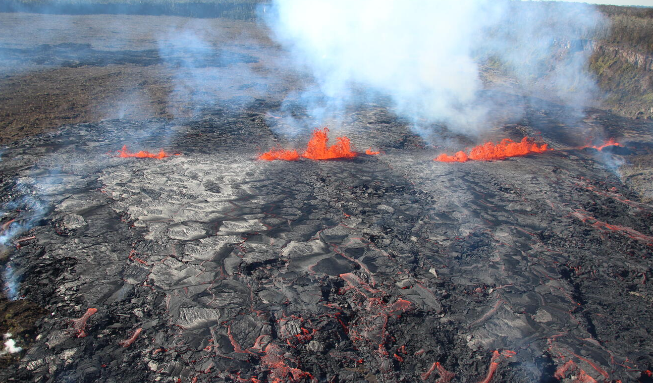
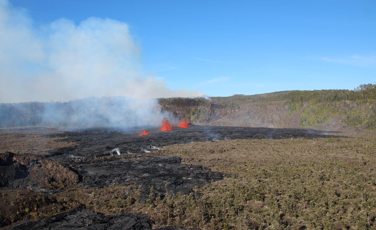
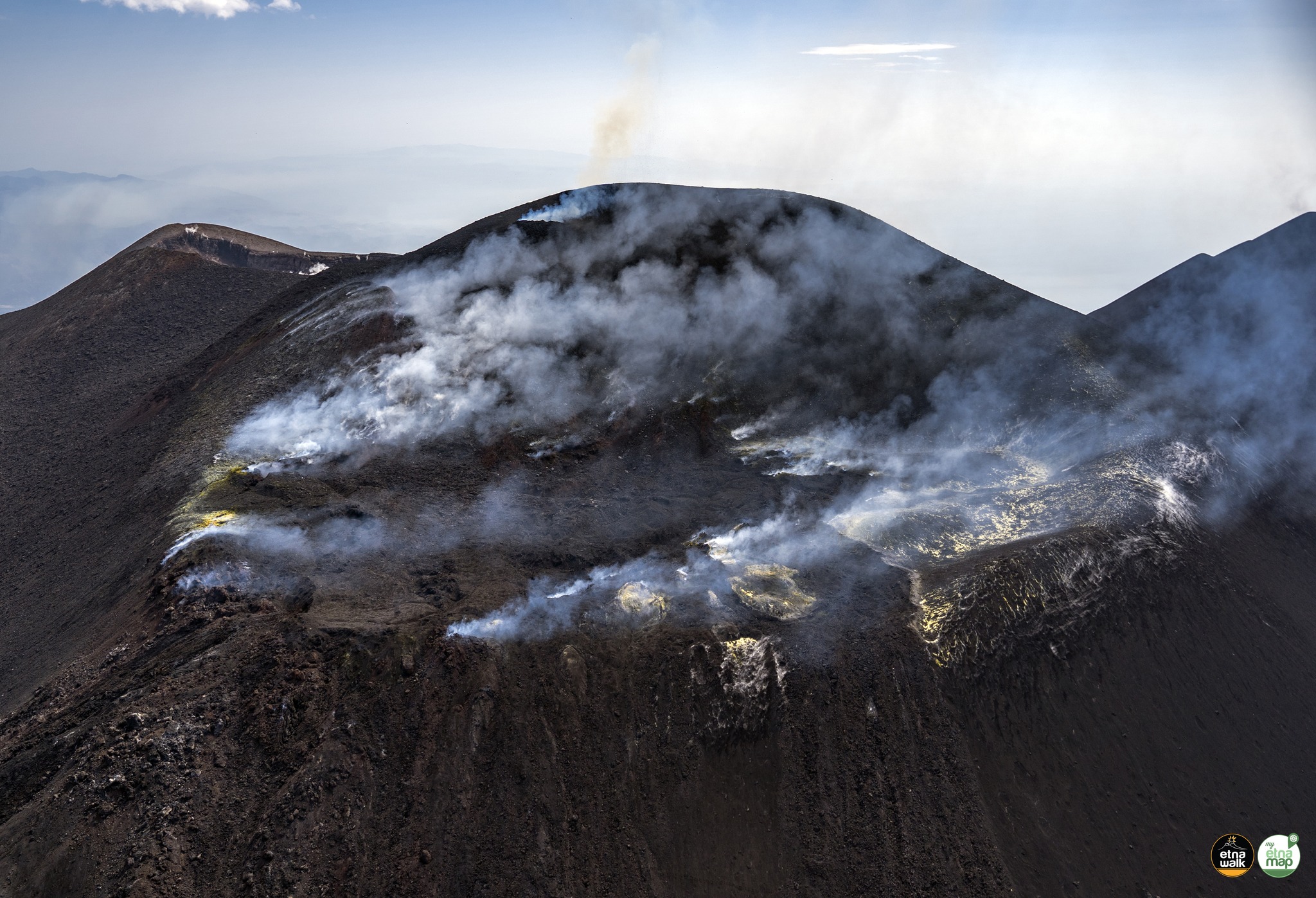
This photograph of the ongoing eruption in Kīlauea’s Middle East Rift Zone was taken during a helicopter flight over the Hawaii Volcano Observatory on the morning of September 17, 2024. This photo was taken at 8:11 a.m. HST. Geologists observed erupting fissures and active lava flows cutting the floor of Nāpau Crater, just downwind (northeast) of the September 15 eruptive fissure. This south-facing view shows current activity from the west side of the crater.
Activity Summary:
Kīlauea volcano is erupting in Hawai’i Volcanoes National Park from a new fissure vent that opened within Nāpau Crater this morning between 4:00 and 5:00 AM HST. Current eruptive activity began with a small eruption that occurred on the evening September 15 from a fissure located just west of Nāpau Crater and lasted a few hours. A second phase of the eruption began at approximately 6:00 PM last night. Activity decreased overnight until approximately 4:00 AM this morning, when a third phase of the eruption began. The eruption is occurring within a closed and remote area of Hawaiʻi Volcanoes National Park. There is no immediate threat to life or infrastructure. Chain of Craters Road, which is closed, is located far downslope and downwind of the eruption. Residents of nearby subdivisions may experience volcanic gas emissions related to this activity which may increase and decrease over the coming hours and days. The Volcano Alert Level/Aviation Color Code remains at WATCH/ORANGE. No changes have been detected in the lower East Rift Zone or Southwest Rift Zone.
Summit Observations:
Approximately 17 earthquakes were detected beneath the Kīlauea summit region over the past 24 hours, at depths of 1–3 km (0.6–1.9 mi) below the ground surface, and with magnitudes of M2 or less. Summit tiltmeters (UWE, SDH, and IKI, to the northwest, southwest, and east of the summit respectively) continued recording deflationary tilt throughout the day yesterday, with UWE recording approximately 10 microradians of tilt in the last 24 hours. This pattern is consistent with magma leaving the summit storage chambers and transferring to the middle East Rift Zone. The most recent measurement of SO2 emission rate at the summit was 75 tonnes per day on August 20, 2024.
Rift Zone Observations:
This morning, several lava fountains approximately ten meters (yards) high are generating lava flows on the floor of Nāpau Crater. This fissure system opened between 4:00 and 5:00 AM HST this morning as detected by NOAA GOES satellite thermal data and USGS Hawaiian Volcano Obseratory (HVO) infrasound, seismic, and camera instruments. Currently, the fissure system in Nāpau is about 0.5 km long (.3 mi) and cuts east-west across the northern crater floor. The fissure appears to have opened just west of Nāpau early this morning and propagated eastward as the eruption progressed. As of 8:30 AM, approximately 25-30% of Nāpau Crater floor has been covered by lava, which is confined to the crater.
This eruption sequence was preceded by intense and localized earthquakes between Maunaulu and Makaopuhi Crater and accompanied by ground deformation patterns indicative of shallow underground crack growth or dike intrusion (a magma filled near vertical crack) began at approximately 6 PM HST on September 14, 2024 (Kīlauea Status Report — Middle East Rift Zone Unrest | U.S. Geological Survey (usgs.gov)). In the following hours, the intensity of earthquake activity decreased, but over 340 shallow earthquakes were detected in the vicinity of the intrusion during the next 24 hours, most within 1 km – 5 km (0.6 mi – 3.1 mi) of the surface. Seismic and deformation data showed that magma was moving beneath the ground from summit storage chambers to the area between Maunaulu and Makaopuhi Crater.
The initial phase of the eruption started on September 15 around 9:00 PM HST and continued until approximately 10:00 PM. Heavy rainfall hampered visibility of the region, but USGS HVO infrasound instruments and seismometers detected a signal typical of gas or steam venting in the middle East Rift Zone and USGS HVO issued a VAN/VONA raising the alert level to Watch/Orange. A helicopter overflight on the morning of September 16 identified several new but inactive fissure segments 480 meters (yards) in total length with small pads of lava extending up to 90 meters (yards) from the fissures. Measurement of sulfur dioxide emission rates along Chain of Craters road downwind of the eruption site during the day of September 16 indicated that the inactive fissure system was emitting around 300 metric tonnes a day.
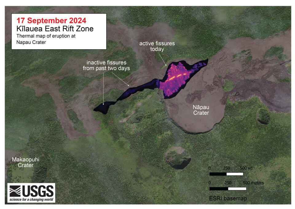
A helicopter overflight on September 17, 2024, allowed for aerial visual and thermal imagery to be collected at the middle East Rift Zone eruption site on Kīlauea. The eruptive activity continues with fountains active within Nāpau Crater and lava flowing on the crater floor, marking an eastward shift in activity compared to September 15. The scale of the thermal map ranges from blue to red, with blue colors indicative of cooler temperatures and red colors indicative of warmer temperatures.
The second phase of the eruption began on September 16 between 6:00 and 7:00 PM HST. This eruptive pulse began with no associated geophysical signals. No changes in seismicity, infrasound, or tilt were observed. It was detected by NOAA GOES satellite thermal imagery and HVO webcam imagery. Eruptive activity gradually decreased throughout the night and ended by the early morning hours of September 17 prior to the onset of the more vigorous third phase that began between 4:00 and 5:00 AM.
All activity is currently confined to the middle East Rift Zone between Makaopuhi Crater and Puʻuʻōʻō and there are no indications further downrift in the MERZ or in the LERZ.
Source : HVO
Photo : USGS/ N. Deligne. USGS.
Italye / Sicily , Etna :
WEEKLY BULLETIN from September 09, 2024 to September 15, 2024 (publication date September 17, 2024)
SUMMARY STATUS OF ACTIVITY
In light of the monitoring data, it emerges:
1) VOLCANOLOGICAL OBSERVATIONS: Degassing activity at the Southeast Crater and the Voragine Crater.
2) SEISMOLOGY: Low seismic activity due to fracturing. Average amplitude of volcanic tremor at a rather average level over the first 5 days of the week. In the following days, the amplitude of the tremor oscillated between the average value and the high value.
3) INFRASOUND: low level infrasound activity. Sources located at the Southeast Crater.
4) GROUND DEFORMATIONS: Ground deformation monitoring networks do not show significant variations
5) GEOCHEMISTRY: SO2 flux at an average and increasing level
The soil CO2 flux is at average values.
The partial pressure of dissolved CO2 in groundwater shows values within seasonal variability
Isotopic ratio: There are no updates.
6) SATELLITE OBSERVATIONS: The thermal activity observed by satellite in the summit area was generally low level with some moderate level thermal anomalies.
7) OTHER OBSERVATIONS: On September 12, drone surveys were carried out to update the topography of the summit area and analyze its morphological changes.
VOLCANOLOGICAL OBSERVATIONS
Monitoring of the volcanic activity of Etna was carried out through the analysis of images from the INGV surveillance camera network, Osservatorio Etneo (INGV-OE) and during an inspection with the use of a drone, carried out on 12 September by INGV staff in the summit area. During the period under review, the observation of the summit craters was discontinuous due to cloud cover.
During the period studied, Etna’s activity was characterized by continuous degassing of varying intensity at the summit craters.
In particular, at the Southeast Crater (SEC), intense degassing was concentrated at the East vent, while a generalized fumarole-type degassing affected the entire summit area of the crater. Continuous degassing has also occurred at the Voragine crater (VOR).
The surveys and observations acquired by drone have made it possible to identify some areas of the summit crater area where degassing vents are located. In particular, one area is located between the Voragine (VOR) and the North-East crater (CNE). It was also possible to observe that the floor of the North-East crater (CNE) is completely obstructed and that several landslides have affected the internal walls of the crater.
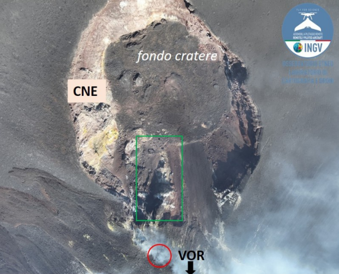
Image acquired by drone on which the floor and the internal walls of the North-East crater are observed. The circle delimits the degassing vent that opened at the edge of the Voragine. The green rectangle delimits a landslide zone of the internal wall of the crater.
Three other vents in the area of the summit crater are located in the western sector of the Bocca Nuova (BN). It is likely that one of these vents produced, on September 16, an emission of ash that quickly dispersed in the atmosphere. Along the western edge of the Bocca Nuova (BN), where the flows exceed the edge of the crater and the fracture, there is a large area of generalized degassing.
Source : INGV.
Photos : Etna Walk/ Giuseppe Distefano ( 03/08/2024) , INGV.
Italy , Stromboli :
WEEKLY BULLETIN from September 09, 2024 to September 15, 2024 (publication date September 17, 2024)
SUMMARY STATUS OF ACTIVITY
In light of the monitoring data, it emerges:
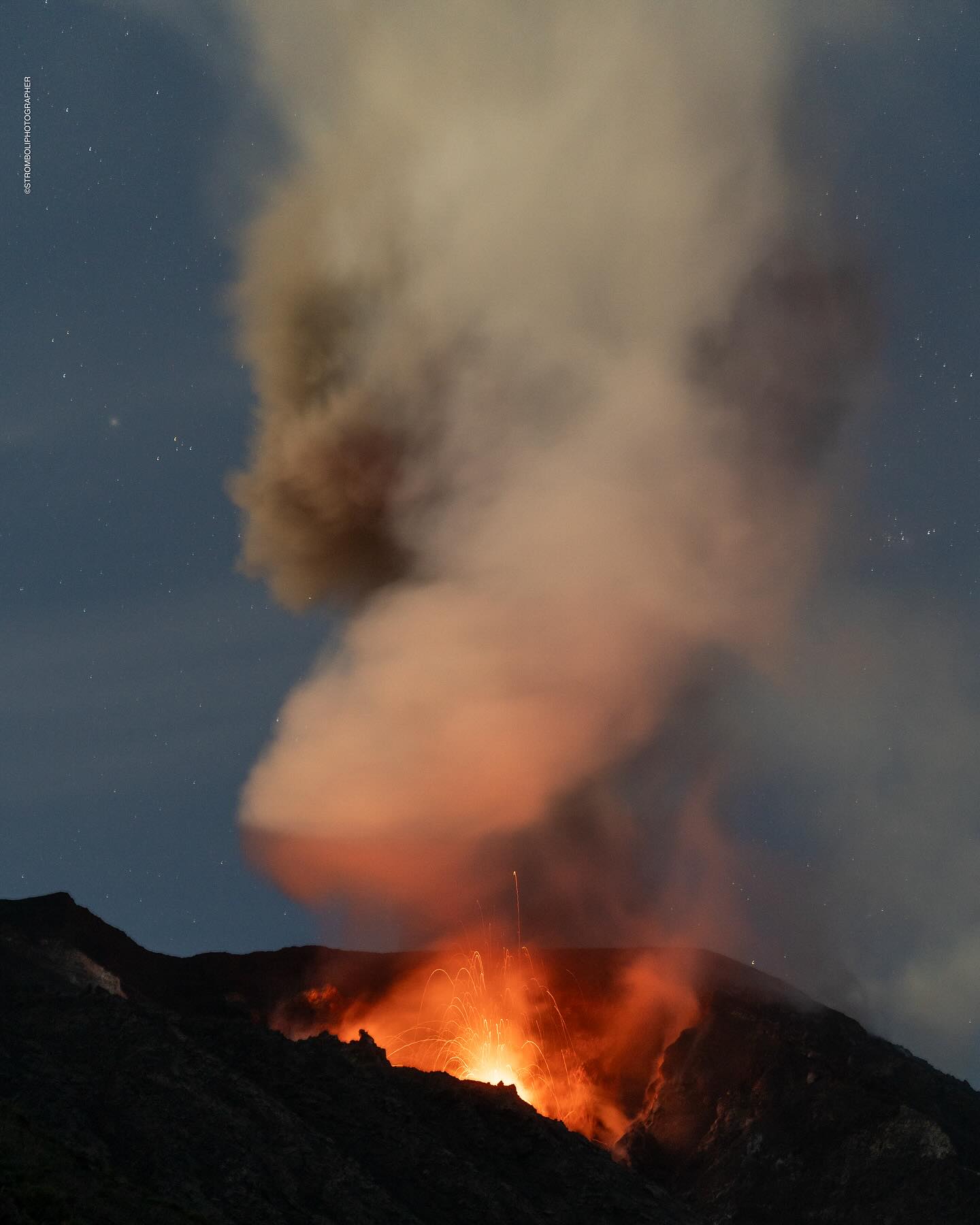
1) VOLCANOLOGICAL OBSERVATIONS: During this period, intense eruptive activity was observed with splashing activity and emission of lava flows from the northern area of the crater. The total hourly frequency fluctuated between average values (6 to 15 events/h). The intensity of the explosions varied from low to medium in the northern crater area and from medium to high in the central-southern area.
2) SEISMOLOGY: The monitored seismological parameters do not show significant variations.
3) GROUND DEFORMATIONS: Ground deformation monitoring networks do not show significant variations
4) GEOCHEMISTRY: SO2 flux at medium level
The CO2 flux from the soil in the STR02 summit area is at medium values.
The CO2/SO2 ratio in the plume is at medium values.
There is no update of the helium isotope ratio in the thermal aquifer.
CO2 flux at Mofeta, in the San Bartolo area: after undergoing some oscillations, it reaches high values.
CO2 flux at Scari: there are no updates due to technical problems in data transmission.
5) SATELLITE OBSERVATIONS: Thermal activity observed by satellite in the summit area was generally low to moderate with some high-level thermal anomalies consistent with spattering activity that fueled a lava overflow on 13 September 2024.
VOLCANOLOGICAL OBSERVATIONS
During the observed period, the eruptive activity of Stromboli was characterized through the analysis of images recorded by the INGV-OE surveillance cameras located at an altitude of 190 m (SCT-SCV) and at Punta dei Corvi (SPCT). The explosive activity was mainly produced by 3 (three) eruptive vents located in the northern area of the crater and by 2 (two) vents located in the central-southern area.
On 13 and 15 September, two lava flows were produced from the northern area of the crater terrace.
Observations of the explosive activity captured by the surveillance cameras
In the area of the northern crater (N), three active vents were observed that produced explosive activity of intensity ranging from low (less than 80 m high) to medium (less than 150 m high). In addition, intense and continuous splashing activity has been observed since September 11. The products emitted during the eruption were mainly coarse materials (bombs and lapilli). The average frequency of explosions ranged from 5 to 11 events/h.
In the South-Central (SC) zone, where at least two chimneys were active, the explosions were of variable intensity ranging from medium (less than 150 m in height) to high (more than 250 m in height) emitting fine materials sometimes mixed with coarse materials. The average frequency of explosions ranged from 1 to 6 events/h.
Lava flows of September 13 and 15, 2024
On September 13 from 12:45 UTC, after a phase of intense splashing activity at the mouths of the North zone, a first flow began to flow from the North zone towards the inside of the incision originating in July. After an initially high emission rate, by early hours of 14 September the flow was no longer fed and was cooling.
The flow products reached the coastline where they formed a modest accumulation.
On 15 September from 03:45 UTC, after a phase of intense spattering activity at the mouths of the North Zone, a second flow began to flow from the North Zone into the incision originating in July. After an initial high emission rate around 13:30 UTC, the lava flow was poorly fed. The flow products reached the coastline where they formed a modest deposit.
Source : INGV
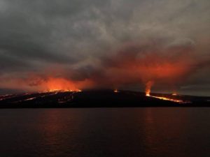
Photo : Stromboli stati d’animo / Sebastiano Cannavo ( 16/9/2024).
Indonesia , Ibu :
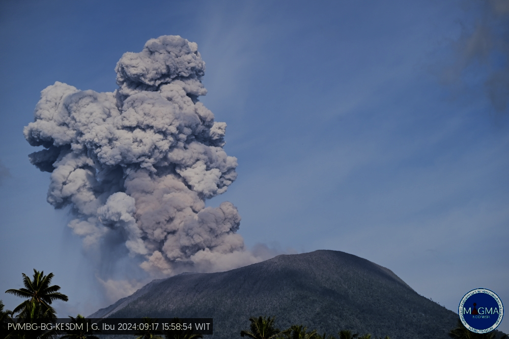
An eruption of Mount Ibu occurred on Tuesday, 17 September 2024 at 15:58 WIT with the height of the ash column observed at ± 1,500 m above the summit (± 2,825 m above sea level). The ash column was grey in colour with a thick intensity, oriented towards the North-East. This eruption was recorded on a seismograph with a maximum amplitude of 28 mm and a duration of 88 seconds.
VOLCANO OBSERVATORY NOTICE FOR AVIATION – VONA
Issued : September 17 , 2024
Volcano : Ibu (268030)
Current Aviation Colour Code : ORANGE
Previous Aviation Colour Code : orange
Source : Ibu Volcano Observatory
Notice Number : 2024IBU782
Volcano Location : N 01 deg 29 min 17 sec E 127 deg 37 min 48 sec
Area : North Maluku, Indonesia
Summit Elevation : 4240 FT (1325 M)
Volcanic Activity Summary :
Eruption with volcanic ash cloud at 06h58 UTC (15h58 local).
Volcanic Cloud Height :
Best estimate of ash-cloud top is around 9040 FT (2825 M) above sea level or 4800 FT (1500 M) above summit. May be higher than what can be observed clearly. Source of height data: ground observer.
Other Volcanic Cloud Information :
Ash cloud moving to northeast. Volcanic ash is observed to be gray. The intensity of volcanic ash is observed to be thick.
Remarks :
Eruption recorded on seismogram with maximum amplitude 28 mm and maximum duration 88 second.
Source et photo : Magma Indonésie .
Colombia , Chiles / Cerro Negro :
San Juan de Pasto, September 17, 2024, 6:30 p.m.
From the monitoring of the activity of the Chiles and Cerro Negro volcanoes, the Colombian Geological Survey (SGC), an entity attached to the Ministry of Mines and Energy, reports that:
In the week of September 10 to 16, 2024, the activity of these volcanoes showed variations in their records, which are part of a stable behavior. Compared to the previous week, the main variations in the monitored parameters were:
• An increase in the frequency of earthquakes was recorded, with a decrease in their released energy.
• The seismicity associated with the fracturing of rocks was predominant, both in terms of occurrence and released energy.
• The recording of seismicity related to the movement of fluids inside volcanic conduits was maintained, which show a very low frequency.
• Fracture earthquakes were located in four sectors, the first to the south of Chiles Volcano, at distances between 1 and 4 km, with depths between 3 km and 6 km from the summit (4,700 m) and a maximum magnitude of 1.7. The second sector was located at the summit and in the collapse zone of Chiles Volcano, at distances between 0.5 and 1.6 km, with depths between 2 and 5 km and a maximum magnitude of 1.6. The third sector was located to the north-northwest of the Chiles summit, at distances close to 6 km, with depths between 5 and 6 km and a maximum local magnitude of 2.1. Finally, the last group of earthquakes was located west of the Chiles summit, at distances between 2 and 3 km, with depths between 3 and 5 km and a maximum magnitude of 2. No felt earthquakes were reported.
• Field sensors and remote satellite sensors that record deformations continued to show changes associated with an inflationary process in the volcanic area.
Based on the above, the SGC recommends closely monitoring its evolution through the weekly bulletins and other information published through our official channels, as well as the instructions of local and departmental authorities and the National Disaster Risk Management Unit (UNGRD).
Volcanic activity remains in yellow alert status: active volcano with changes in the behavior of the base level of the monitored parameters and other manifestations.
Source et photo : SGC