September 16 , 2024.
Hawaii , Kilauea :
Sunday, September 15, 2024, 8:00 AM HST (Sunday, September 15, 2024, 18:00 UTC)
19°25’16 » N 155°17’13 » W,
Summit Elevation 4091 ft (1247 m)
Current Volcano Alert Level: ADVISORY
Current Aviation Color Code: YELLOW
Activity Summary:
Kīlauea is not erupting. Seismicity and deformation increased dramatically at 6 p.m. yesterday in the middle East Rift Zone just northwest of Makaopuhi Crater indicating intrusion of magma beneath this area. Activity has continued to decrease in intensity overnight, but continues at lower levels this morning. Renewed episodes of unrest in the upper to middle East Rift Zone are possible and may evolve quickly.
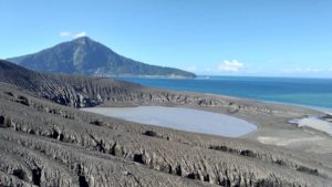
Panoramic photograph of Makaopuhi Crater in Kīlauea’s Middle East Rift Zone. Makapohi Crater is located between Maunaulu and Puʻuʻōʻō, two lava shields that formed during long-term (years) eruptions in the Middle East Rift Zone. Kānenuiohamo, visible in the background of this photograph, is another long-term lava shield in the Middle East Rift Zone that formed at least several hundred years ago.
Summit Observations:
Seismometers detected 40 earthquakes beneath Kīlauea’s broader summit region over the past day, including a magnitude 4.3 earthquake at 4:25 p.m. yesterday, September 14. Most were at depths between 1 km – 3 km (0.6 mi – 1.9 mi) below the surface. The Uēkahuna tiltmeter at the summit began recording significant deflation around 7 p.m. yesterday, about an hour after the seismic swarm began in the middle East Rift Zone yesterday. By this morning, the tiltmeter recorded about 7 microradians of deflation related to the middle East Rift zone event.The most recent measurement of SO2 emission rate was 75 tonnes per day on August 20, 2024.
Rift Zone Observations:
Just after 6 p.m. yesterday (September 14) a seismic swarm began in the middle East Rift Zone (MERZ) accompanied by inflationary tilt recorded on the Escape Road (ESC) and Puʻuʻōʻō cone (POC) tiltmeters (Kīlauea Status Report — Middle East Rift Zone Unrest | U.S. Geological Survey (usgs.gov)). The combined seismicity and deformation patterns suggest that a dike was emplaced in the region just northwest of Makaopuhi Crater where an Interferometric SAR (InSAR) image spanning from August 28 to September 12, had identified uplift. There have been 280 earthquakes recorded in this area in the last 24 hours, with most occurring since 6 p.m. last night when activity peaked at 30 earthquakes per hour. By this morning, the size of earthquakes has decreased, but pulses of up to 25 earthquakes per hour continue. Local deformation recorded at the ESC and POC tiltmeters slowed significantly by 4 a.m. this morning with little deformation recorded since then.
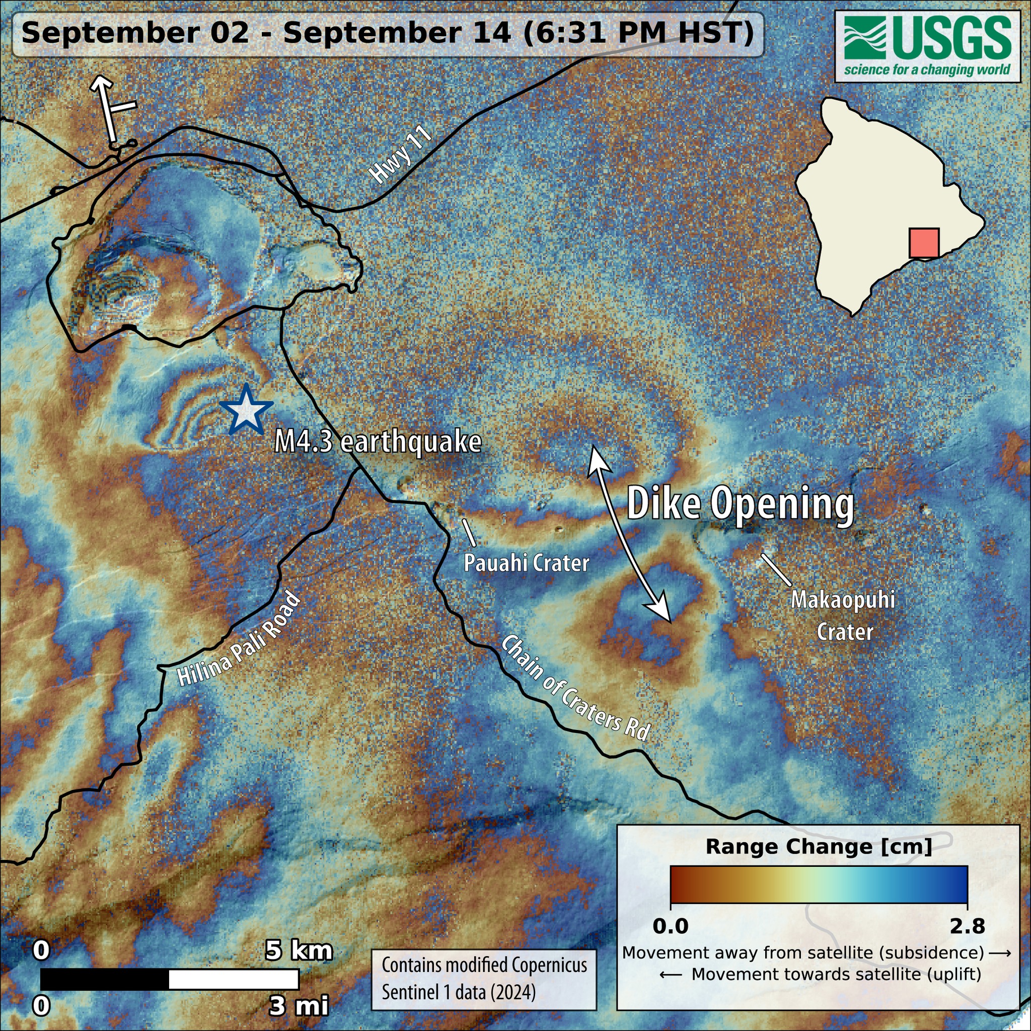
This map shows recent deformation at #Kīlauea during September 2–14, 2024. Data were acquired by the European Space Agency’s #Sentinel-1A satellite. Colored fringes denote areas of ground deformation, with more fringes indicating more deformation. Each color cycle represents 2.8 cm (1.1 in) of ground motion. The symbol in the upper left indicates the satellite’s orbit direction (arrow) and look direction (bar).
The butterfly-shaped pattern between Pauahi and Makaopuhi Craters on the middle East Rift Zone indicates surface extension over this time period as magma intruded underground. Increased earthquake activity associated with the intrusion of magma began around 4 p.m. HST on September 14 and is ongoing as of the afternoon of September 15, although it has decreased in intensity.
The largest earthquake during the magmatic intrusion, a magnitude-4.3 in the south part of Kaluapele (the caldera), was associated with slip along one of the outer caldera faults—a consequence of stress changes due to the intrusion. This is the cause of the localized pattern of fringes in the south part of the caldera.
Activity in other parts of the East Rift Zone to the east or downrift of Puʻuʻōʻō (the site of 1983–2018 eruptive activity) remains low. GPS instruments have recorded periods of inflation in portions of the middle East Rift Zone (MERZ) uprift of Puʻuʻōʻō during the past month. Measurements from continuous gas monitoring stations downwind of Puʻuʻōʻō in the MERZ remain below detection limits for SO2, indicating that SO2 emissions from this area are negligible.
Source : HVO
Photos : USGS/ K. Mulliken. Sentinel-1A
Italy / Sicily , Etna :
Etna Activity Report, 16 September 2024, 04:30 (02:30 UTC) .
The National Institute of Geophysics and Volcanology, Osservatorio Etneo, reports that, based on observations made with video surveillance cameras, the degassing activity of the summit craters continues, mainly affecting the Voragine and the Southeast crater. Currently, no significant changes in volcanic activity are observed. Since 17:00 UTC yesterday, the volcanic tremor has shown rapid variations in amplitude that reach slightly high values.
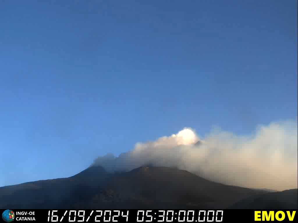
The last one, which started today at 01:00 UTC, was the strongest at the moment and reached its maximum value at 01:45 UTC. The locations of the source of the tremor are located in the Bocca Nuova crater at 3000 m altitude. The GNSS and inclinometric networks for monitoring ground deformations do not record significant variations.
Further updates will be communicated shortly.
Source : INGV
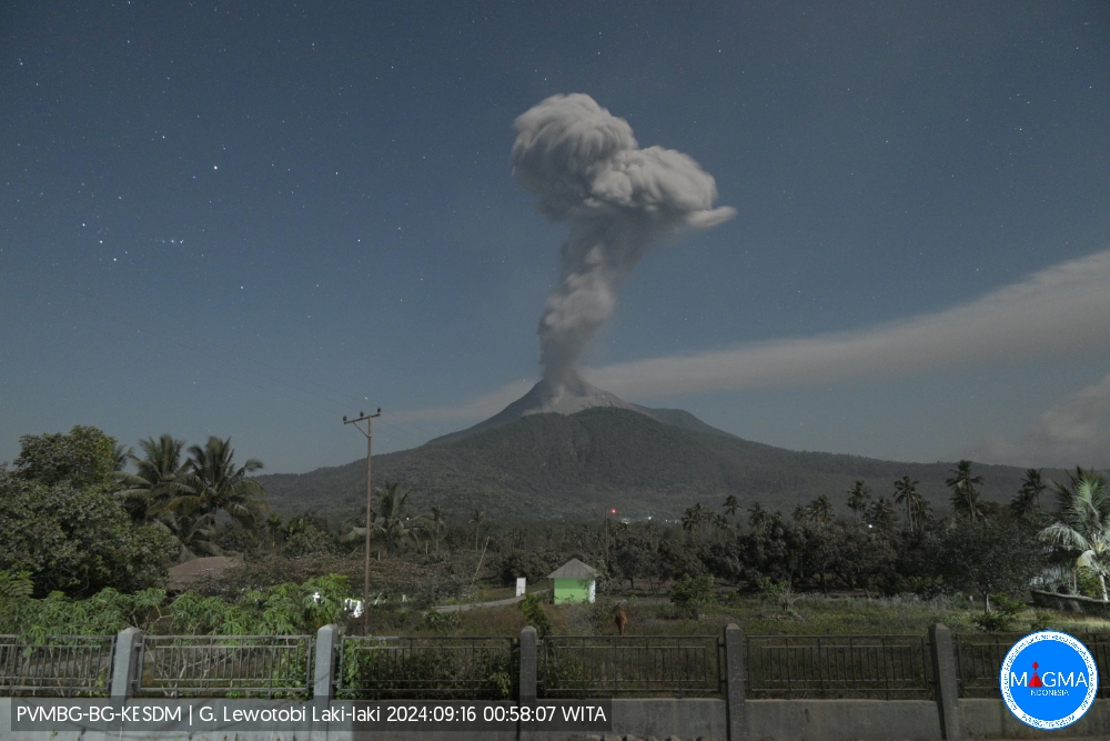
Indonesia , Lewotobi Laki-laki :
An eruption of Lewotobi Laki Laki occurred on Monday, September 16, 2024 at 00:54 WITA with the height of the ash column observed at ± 1000 m above the summit (± 2584 m above sea level). The ash column was observed to be gray with a thick intensity, oriented to the West and Northwest. This eruption was recorded on a seismograph with a maximum amplitude of 41.1 mm and a duration of 166 seconds.
VOLCANO OBSERVATORY NOTICE FOR AVIATION – VONA
Issued : September 15 , 2024.
Volcano : Lewotobi Laki-laki (264180)
Current Aviation Colour Code : ORANGE
Previous Aviation Colour Code : orange
Source : Lewotobi Laki-laki Volcano Observatory
Notice Number : 2024LWK510
Volcano Location : S 08 deg 32 min 20 sec E 122 deg 46 min 06 sec
Area : East Nusa Tenggara, Indonesia
Summit Elevation : 5069 FT (1584 M)
Volcanic Activity Summary :
Eruption with volcanic ash cloud at 16h54 UTC (00h54 local).
Volcanic Cloud Height :
Best estimate of ash-cloud top is around 8269 FT (2584 M) above sea level or 3200 FT (1000 M) above summit. May be higher than what can be observed clearly. Source of height data: ground observer.
Other Volcanic Cloud Information :
Ash cloud moving from west to northwest. Volcanic ash is observed to be gray. The intensity of volcanic ash is observed to be thick.
Remarks :
Eruption recorded on seismogram with maximum amplitude 41.4 mm and maximum duration 166 second.
Source et photo : Magma Indonésie.
Ecuador , El Reventador :
DAILY STATE REPORT OF THE REVENTADOR VOLCANO , Sunday, September 15, 2024.
Information Geophysical Institute – EPN.
Surface Activity Level: High , Surface Trend: No Change
Internal Activity Level: Moderate , Internal Trend: No Change
From September 14, 2024, 11:00 a.m. to September 15, 2024, 11:00 a.m.:
Seismicity:
The count of seismic events recorded at the station is detailed below.
Explosion (EXP) 116
Long Period (LP) 14
Emission Tremor (TREMI) 11
Harmonic Tremor (TRARM) 7
Rainfall / Lahars:
No rain was recorded in the areas surrounding the volcano. **Heavy rains could remobilize the accumulated materials and generate mudflows with debris (lahars), which could descend on the flanks of the volcano and flow into adjacent rivers**.
Emissions/ash column:
Due to transmission problems, observation via surveillance cameras was not possible. On the other hand, thanks to the GOES-16 satellite system, yesterday afternoon and evening, 2 emissions of gas and ash were recorded, with heights of 1000 and 1300 meters above the level of the crater, in a West and North-West direction. In connection with this activity, the Washington VAAC agency has published 4 reports of ash clouds in a West, Northwest and West-Northwest direction, with heights between 1,000 and 1,300 meters above the crater level.
Other monitoring parameters:
Satellite platforms: FIRMS: recorded 6 thermal anomalies, MIROVA-MODIS: 3 thermal anomalies and MIROVA-VIIRS: 1 thermal anomaly.
Observation:
Thanks to satellite monitoring, since yesterday afternoon at the closing of this report, it is observed that the volcanic sector remains partially cloudy.
Alert level: Orange
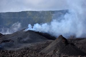
Source et Photo :IGEPN ( 6/2024)
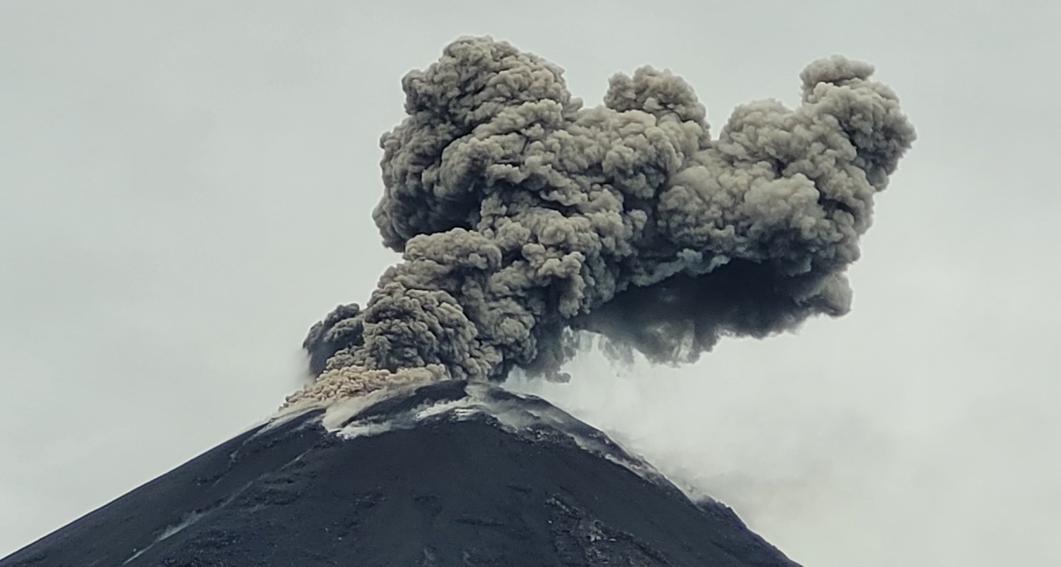
Guatemala , Santiaguito:
Atmospheric conditions: Clear weather.
Wind: from the East.
Precipitation: 9.0 mm.
Activity:
A constant degassing, of weak and moderate characteristics, is observed on the Caliente dome, reaching up to 700 m in height. In the early morning, weak explosions were recorded, causing incandescence and avalanches in a West, South-West and South-East direction. It is not excluded that explosions and avalanches of moderate characteristics could occur, which could form a column of gas and ash reaching a height of up to 3,400 meters above sea level (10,498 feet).
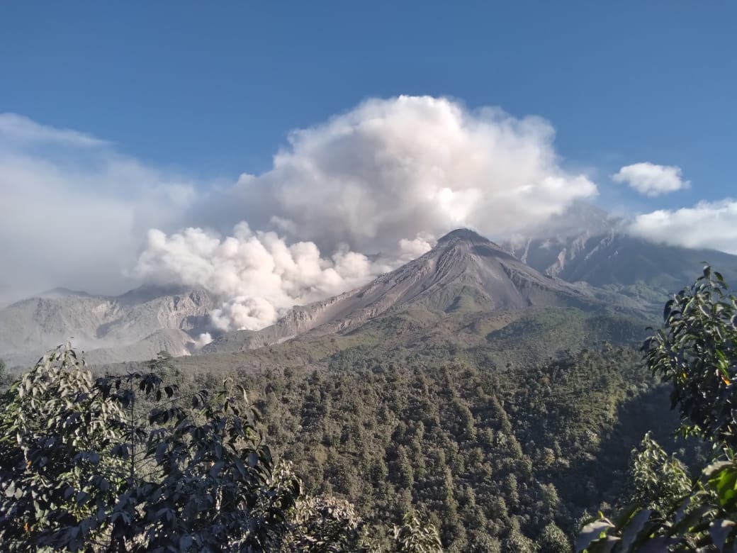
These ashes can spread 10 to 30 km to the West and Northwest, causing fine ash falls in the community of San Marcos Palajunoj and Loma Linda. Strong avalanches and audible noises are possible several kilometers from the volcanic edifice. The occurrence of moderate to strong block and ash flows is not excluded, as well as possible long-distance pyroclastic flows in different directions, so follow the recommendations of the special bulletin BESAN-004-2024.
Source : Insivumeh
Photo : Noticias la Red GT San José del Golfo ( 2022).