September 11 , 2024.
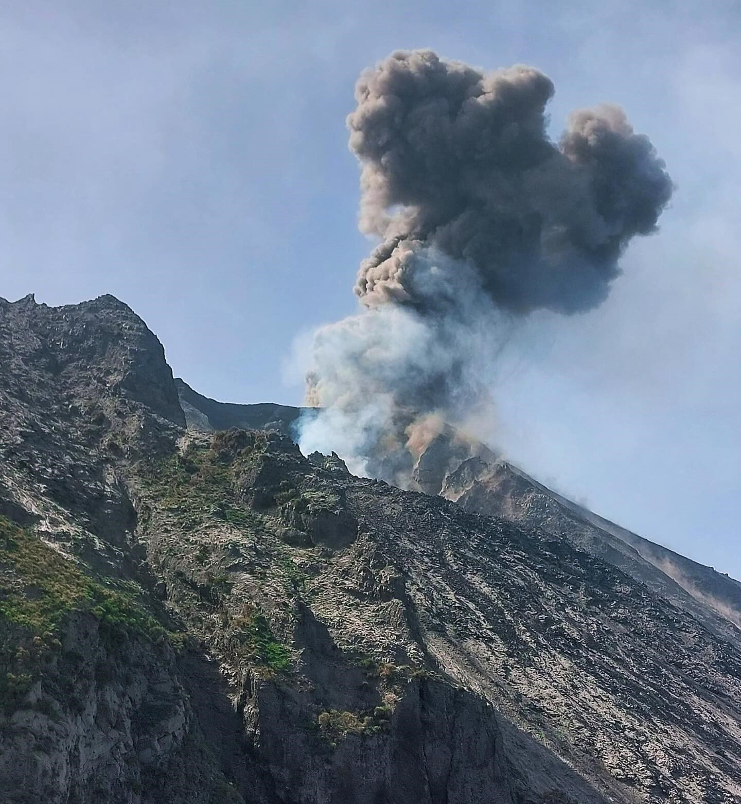
Italy , Stromboli :
WEEKLY BULLETIN, from September 02, 2024 to September 08, 2024. (issue date September 10, 2024)
SUMMARY STATUS OF ACTIVITY
In light of the monitoring data, it emerges:
1) VOLCANOLOGICAL OBSERVATIONS: During this period, intense eruptive activity with splashes was observed. The total hourly frequency fluctuated between medium values (6 events/h) and high values (18 events/h). The intensity of the explosions varied from low to medium in the North Crater area and from medium to high in the CS area.
2) SEISMOLOGY: The monitored seismological parameters do not show significant variations.
3) GROUND DEFORMATIONS: No significant changes were reported in the time series of ground deformation monitoring stations during the last week.
4) GEOCHEMISTRY: SO2 flux at medium level
The CO2 flux from soils in the STR02 summit area is at medium values.
The CO2/SO2 ratio in the plume is at medium values.
There is no update of the helium isotope ratio in the thermal aquifer.
CO2 flux at Mofeta in the San Bartolo area: high values.
CO2 flux at Scari: there are no updates due to technical problems in data transmission.
5) SATELLITE OBSERVATIONS: The thermal activity observed by satellite in the summit area was generally low with some isolated thermal anomalies of moderate level.
VOLCANOLOGICAL OBSERVATIONS
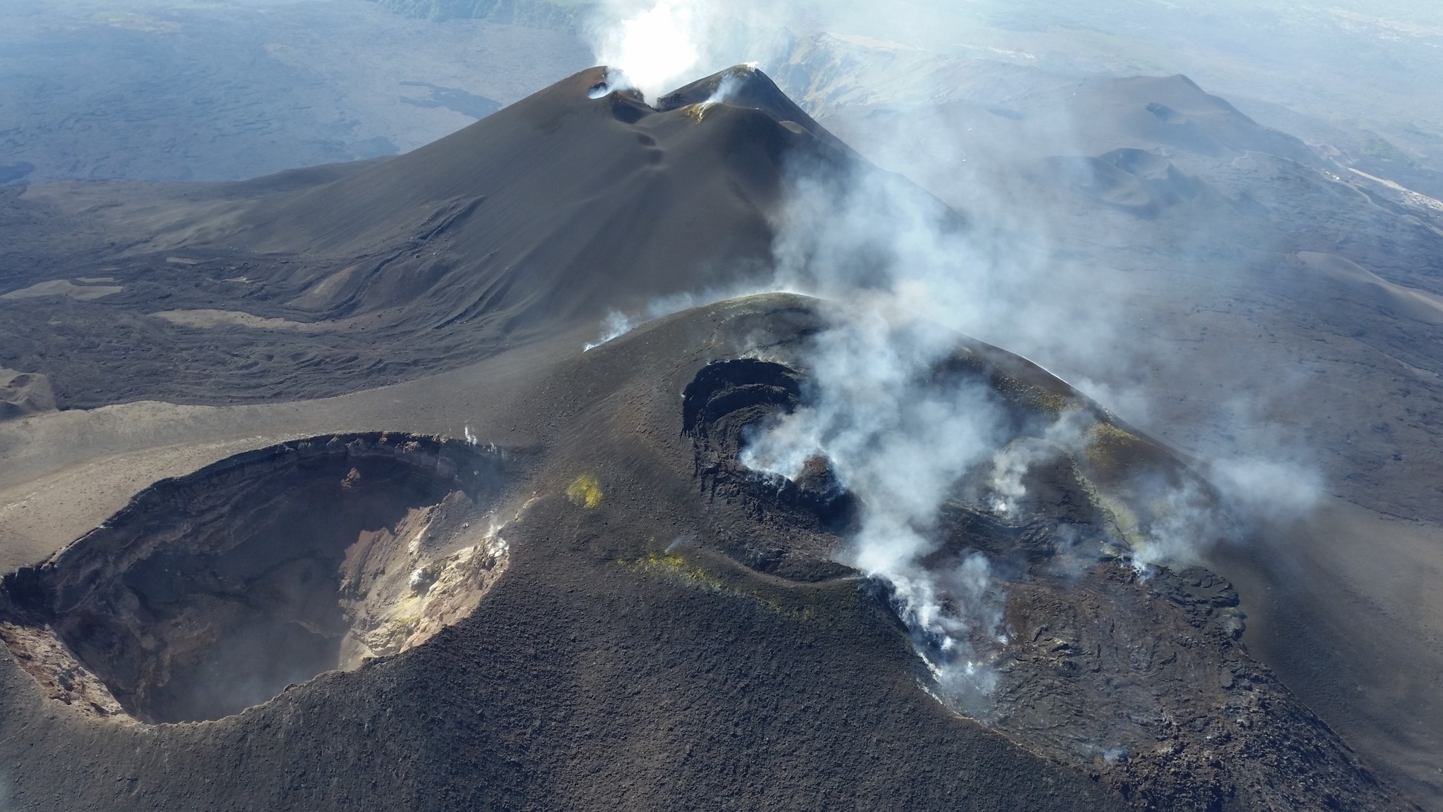
During the observed period, the eruptive activity of Stromboli was characterized by analyzing the images recorded by the INGV-OE surveillance cameras located at an altitude of 190 m (SCT-SCV) and at Punta dei Corvi (SPCT). The explosive activity was mainly produced by 3 (three) eruptive vents located in the North area of the crater and by 2 (two) vents located in the South-Central area.
Observations of the explosive activity captured by the surveillance cameras
In the North (N) crater area, three active vents were observed that produced low-intensity explosive activity (less than 80 m in height). In addition, a projection activity was observed that was more intense on 6 and 7 September. The eruption products were mainly composed of coarse materials (bombs and lapilli) with occasional fine materials (ash). The average frequency of explosions ranged from 5 to 13 events/h. In the Centre-South (CS) area, the explosions were of variable intensity ranging from medium (less than 150 m in height) to high (more than 250 m in height) emitting fine materials sometimes mixed with coarse ones. The average frequency of explosions ranged from 2 to 5 events/h.
Field observations of September 7, 2024
On the morning of September 7, the researchers carried out an inspection at an altitude of 400 m, where they observed explosive activity, sometimes intense, coming from the vents located in the northern zone of the crater with low-level projection activity (around 06:35) and explosions coming from the Centre-South (CS) area with abundant emission of ash that reached a height of a few hundred meters with a frequency of about 10-15 minutes.
Source : INGV
Photo : Stromboli Adventures ( 9/9/2024)
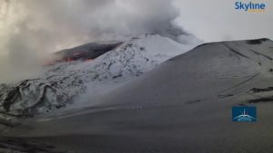
Italy / Sicily , Etna :
WEEKLY BULLETIN, from September 02, 2024 to September 08, 2024. (issue date September 10, 2024)
SUMMARY STATUS OF ACTIVITY
In light of the monitoring data, it appears:
1) VOLCANOLOGICAL OBSERVATIONS: Degassing of the summit craters, in particular the eastern mouth of the Southeast Crater and the Voragine Crater.
2) SEISMOLOGY: Low seismic activity due to fracturing. Average amplitude of volcanic tremor in the middle and low levels.
3) INFRASOUND: Infrasound activity almost absent.
4) GROUND DEFORMATION: The ground deformation monitoring networks did not show any significant variations during the week.
5) GEOCHEMISTRY: SO2 flux at low-medium level
The soil CO2 flux shows very high and increasing values.
The partial pressure of dissolved CO2 in groundwater shows values in seasonal variability
The isotopic ratio in peripheral terrains on high values.
6) SATELLITE OBSERVATIONS: The thermal activity observed by satellite in the summit area was generally low with some isolated thermal anomalies of moderate level.
VOLCANOLOGICAL OBSERVATIONS
During the week in question, the monitoring of the volcanic activity of Etna was carried out through the analysis of images from the surveillance camera network of the National Institute of Geophysics and Volcanology – Osservatorio Etneo (INGV-OE).
Due to the cloud cover, the observation of the summit craters was often discontinuous.
In general, during the observation period, the activity of Etna was characterized by a continuous degassing of variable intensity from the summit craters and in particular in the eastern mouth of the South-East crater and in the Voragine crater, made particularly evident – especially in the absence of wind – by the high levels of atmospheric humidity that characterized the weather conditions of the period.
Source : INGV
Photo : Etnair srl ( 08/2024).
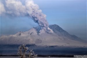
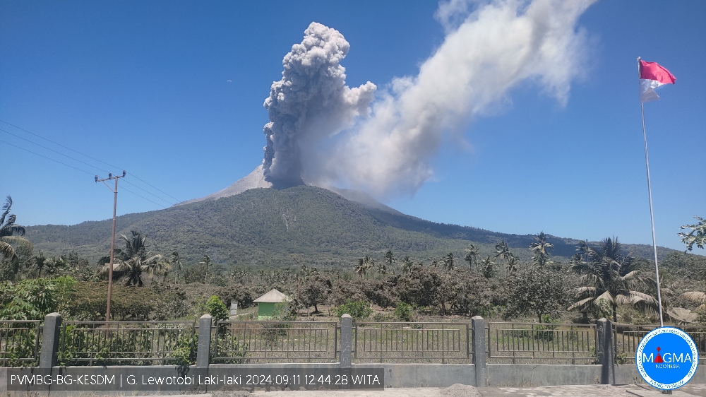
Indonésie , Lewotobi Laki-laki :
An eruption of Lewotobi Laki Laki occurred on Wednesday, September 11, 2024 at 12:42 WITA with the height of the ash column observed at ± 800 m above the summit (± 2384 m above sea level). The ash column was observed to be gray with a thick intensity, oriented to the West and Northwest. This eruption was recorded on a seismograph with a maximum amplitude of 6.66 mm and a duration of 209 seconds.
VOLCANO OBSERVATORY NOTICE FOR AVIATION – VONA
Issued : September 11 , 2024
Volcano : Lewotobi Laki-laki (264180)
Current Aviation Colour Code : ORANGE
Previous Aviation Colour Code : orange
Source : Lewotobi Laki-laki Volcano Observatory
Notice Number : 2024LWK489
Volcano Location : S 08 deg 32 min 20 sec E 122 deg 46 min 06 sec
Area : East Nusa Tenggara, Indonesia
Summit Elevation : 5069 FT (1584 M)
Volcanic Activity Summary :
Eruption with volcanic ash cloud at 04h42 UTC (12h42 local).
Volcanic Cloud Height :
Best estimate of ash-cloud top is around 7629 FT (2384 M) above sea level or 2560 FT (800 M) above summit. May be higher than what can be observed clearly. Source of height data: ground observer.
Other Volcanic Cloud Information :
Ash cloud moving from west to northwest. Volcanic ash is observed to be gray. The intensity of volcanic ash is observed to be thick.
Remarks :
Eruption recorded on seismogram with maximum amplitude 6.66 mm and maximum duration 209 second.
Source et photo : Magma Indonésie.
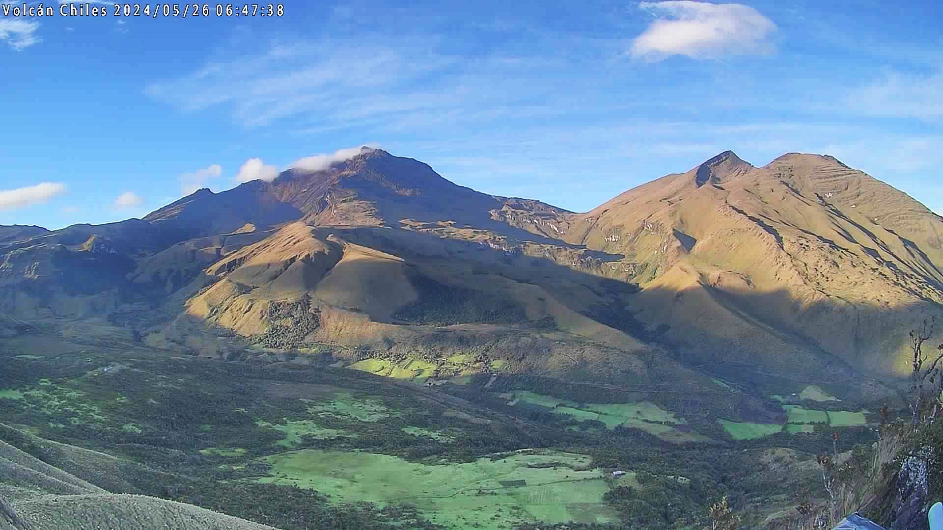
Colombia , Chiles / Cerro Negro :
San Juan de Pasto, September 10, 2024, 5:50 p.m.
From the monitoring of the activity of the Chiles and Cerro Negro volcanoes, the Colombian Geological Survey (SGC), an entity attached to the Ministry of Mines and Energy, reports that:
During the week of September 3 to 9, 2024, the activity of these volcanoes showed variations in their records, which are part of a stable behavior.
Compared to the previous week, the main variations in the monitored parameters were:
• A decrease in the frequency of earthquakes was recorded, with an increase in the energy released.
• The predominance of seismicity associated with rock fractures within the volcanic system was maintained.
• The recording of seismicity related to the movement of fluids within these volcanoes was also maintained; with some of these very low frequency content events representing the largest energy contribution of the week.
• Earthquakes related to fracture processes continued to be located mainly in the collapse zone of the Chiles volcano, at depths between 2 km and 4 km from the summit (4,700 m) and with magnitudes less than 1. Other events were located scattered, at distances less than 12 km, with depths between 4 and 9 km from its summit and with a maximum magnitude of 2. No felt earthquakes were reported for this period.
• Field deformation sensors and remote satellite sensors continued to record changes associated with an inflationary process in the volcanic area.
Based on the above, the SGC recommends closely monitoring the evolution through weekly bulletins and other information published through our official channels, as well as instructions from local and departmental authorities and the National Disaster Risk Management Unit (UNGRD).
Volcanic activity remains in yellow alert status: active volcano with changes in the behavior of the base level of monitored parameters and other manifestations.
Source et photo : SGC
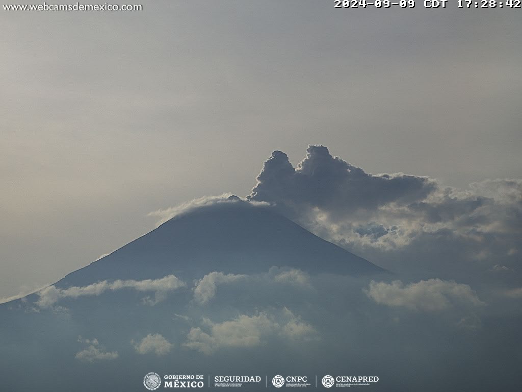
Mexico , Popocatepetl :
September 10, 11:00 (September 10, 17:00 GMT) , Activity in the last 24 hours
31 exhalations were detected, accompanied by water vapor, volcanic gases and light amounts of ash. In addition, 205 minutes of very low amplitude tremors and 34 minutes of low intensity exhalation sequences were identified.
At the moment, there is no visibility towards the volcano due to the weather conditions in the area.
The Popocatépetl volcanic alert fire is in yellow phase 2.
The scenarios expected for this phase are:
Some smaller to moderate explosions
Appearance of tremors of varying amplitude
Light to moderate ash rains in the surrounding towns and in some more distant towns
Ejection of incandescent fragments within the 12-kilometer exclusion radius
The appearance of lahars can be expected to descend into the ravines, due to the accumulation of ash on the slopes and its interaction with the rains expected in the coming weeks.
Possibility of pyroclastic flows not reaching the populations
The information published here is the result of permanent monitoring of the Popocatépetl volcano, carried out in coordination with the National Autonomous University of Mexico.
The report is published daily at 11 a.m., here is summarized the activity recorded in the last 24 hours; that is, from 10 a.m. the previous day to 10 a.m. the current day. If an extraordinary event occurs, it will be reported immediately.
Source et photo : Cenapred.