September 10 , 2024.
Philippines , Kanlaon :
KANLAON VOLCANO ADVISORY , 9 September 2024 , 11:30 PM
Notice of increased seismic activity at Kanlaon Volcano.
A total of twenty-five (25) volcano-tectonic or VT earthquakes have been recorded by the Kanlaon Volcano Network since 8:32 AM this morning, with the last 22 having been recorded beginning 10:35 PM this evening. Canlaon City, Negros Oriental residents report that at least five of these earthquakes were felt. VT earthquakes are generated by rock fracturing processes and the increase in VT activity may possibly precede eruptive activity.
KANLAON VOLCANO ADVISORY , 10 September 2024 , 11:00 AM
Notice of increased seismic activity at Kanlaon Volcano.
A total of two hundred eighty-eight (288) volcano-tectonic or VT earthquakes have been recorded by the Kanlaon Volcano Network since 08:30 PM of 09 September 2024. The events were generated between 0 to 9 kilometers depths beneath the north-eastern flanks of the volcanic edifice and the strongest events were felt at Intensity II in some barangays of Canlaon City, Negros Oriental. Rumbling sounds were reported by some residents of Bago City. Strong sulfur fumes have been reported in a few barangays in Bago, La Carlota and Canlaon Cities. VT earthquakes are generated by rock fracturing processes and the increase in VT activity strongly indicates progressive rock-fracturing beneath the volcano as rising magma drives a path towards the surface.
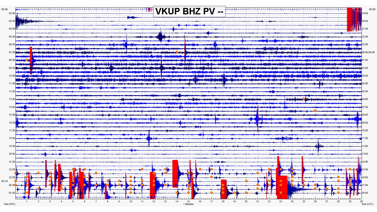
The public is reminded that Alert Level 2 (increasing unrest) prevails over Kanlaon, but that current seismic activity may lead to eruptive unrest and an increase in the Alert Level. The public is strongly advised to be ready and vigilant, and to avoid entry into the four (4) kilometer-radius Permanent Danger Zone (PDZ) to minimize risks from volcanic hazards such as pyroclastic density currents, ballistic projectiles, rockfall and others. In case of ash fall events that may affect communities downwind of Kanlaon’s crater, people should cover their nose and mouth with a damp, clean cloth or dust mask. Civil aviation authorities must also advise pilots to avoid flying close to the volcano’s summit as ash and ballistic fragments from sudden eruption can be hazardous to aircraft. Communities living beside river systems on the southern and western slopes, especially those that have already experienced lahars and muddy streamflows, are advised to take precautionary measures when heavy rainfall over the volcano has been forecast or has begun.
DOST-PHIVOLCS maintains close monitoring of Kanlaon Volcano and any new development will be immediately communicated to all concerned stakeholders.
The local government of Canlaon City, Negros Oriental, has ordered a mandatory evacuation of residents within the 4-kilometer Permanent Danger Zone around Mt. Kanlaon following an earthquake swarm linked to the volcano’s increased activity.
Canlaon City Mayor Jose Chubasco Cardenas issued Executive Order No. 63, series of 2024, on Tuesday, citing the need to protect residents as more than 200 earthquakes were recorded since 10:35 p.m. on Monday evening. The Philippine Institute of Volcanology and Seismology (Phivolcs) has been closely monitoring the situation.
Phivolcs resident volcanologist Andylene Quintia confirmed the earthquake swarm and noted that the seismic events occurred at short intervals. The agency is coordinating with geologists to assess the latest developments.
Source : Phivolcs , Pna.gov.ph
Photos : Phivolcs , Bebie Sarol
Indonesia , Ibu :
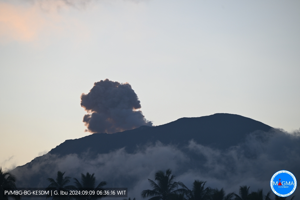
Mount Ibu erupted on Monday, 9 September 2024 at 06:35 WIT with the height of the ash column observed at ± 300 m above the summit (± 1625 m above sea level). The ash column was observed to be grey in colour with a thick intensity, oriented towards the North-East. This eruption was recorded on a seismograph with a maximum amplitude of 28 mm and a duration of 65 seconds.
VOLCANO OBSERVATORY NOTICE FOR AVIATION – VONA
Issued : September 09 2024
Volcano : Ibu (268030)
Current Aviation Colour Code : ORANGE
Previous Aviation Colour Code : orange
Source : Ibu Volcano Observatory
Notice Number : 2024IBU730
Volcano Location : N 01 deg 29 min 17 sec E 127 deg 37 min 48 sec
Area : North Maluku, Indonesia
Summit Elevation : 4240 FT (1325 M)
Volcanic Activity Summary :
Eruption with volcanic ash cloud at 21h35 UTC (06h35 local).
Volcanic Cloud Height :
Best estimate of ash-cloud top is around 5200 FT (1625 M) above sea level or 960 FT (300 M) above summit. May be higher than what can be observed clearly. Source of height data: ground observer.
Other Volcanic Cloud Information :
Ash cloud moving to northeast. Volcanic ash is observed to be gray. The intensity of volcanic ash is observed to be thick.
Remarks :
Eruption recorded on seismogram with maximum amplitude 28 mm and maximum duration 65 second.
Source et photo : Magma Indonésie .
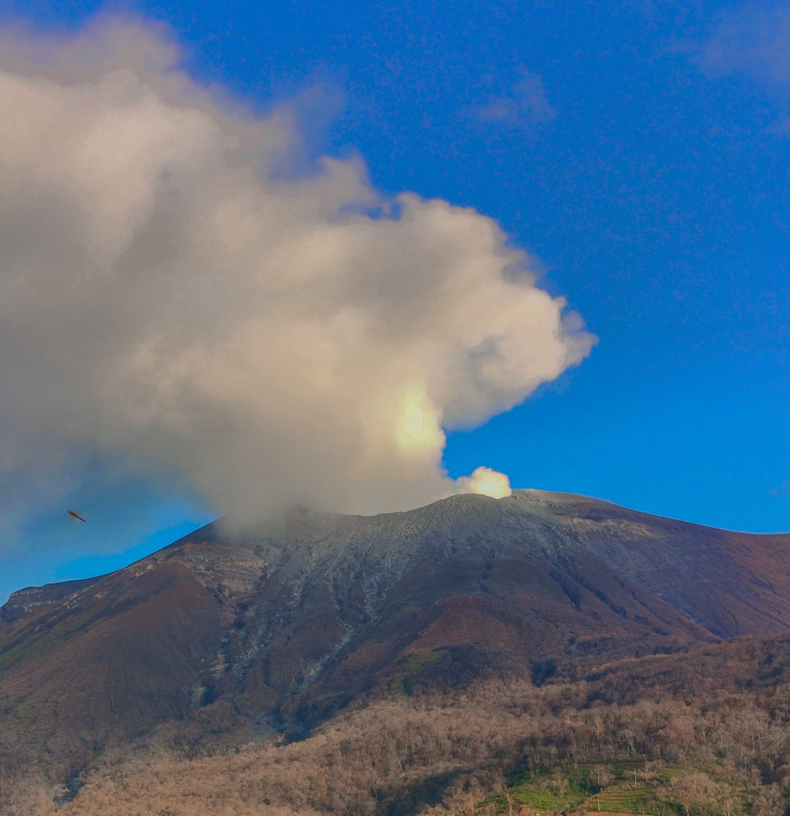
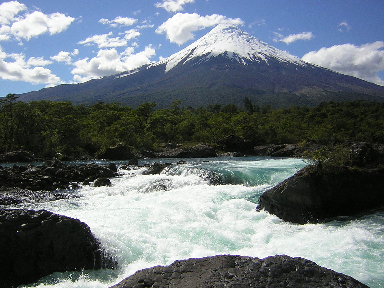
Chile , Osorno :
Special Report on Volcanic Activity (REAV), Los Lagos region, Osorno Volcano, September 9, 2024, 1:40 p.m. local time (Continental Chile)
The National Geology and Mining Service of Chile (Sernageomin) announces the following PRELIMINARY information, obtained through the monitoring equipment of the National Volcanic Monitoring Network (RNVV), processed and analyzed at the Volcanological Observatory of the Southern Andes (Ovdas):
On Monday, September 9, 2024 at 12:45 p.m. local time (15:45 UTC), the monitoring stations installed near the Osorno Volcano recorded an earthquake associated with the fracturing of rocks within the volcanic system (distal volcano type).
The characteristics of the earthquake after its analysis are as follows:
TIME OF ORIGIN: 12:45 local time (15:45 UTC)
LATITUDE: 41.162° S
LONGITUDE: 72.535° West
DEPTH: 12.2 km
LOCAL MAGNITUDE: 3.8 (ML)
Observations:
Due to its characteristics and distance from the volcanic center, this event is associated with tectonic activity, classifying it as a volcano-distal event (VD).
Following this earthquake, an aftershock of lower magnitude (ML 2.1) was recorded
No changes in the seismic behavior of the volcano were recorded.
The volcanic technical alert remains at Green level.
Source : Sernageomin.
Photo : Wikipedia ( 2019) .
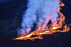
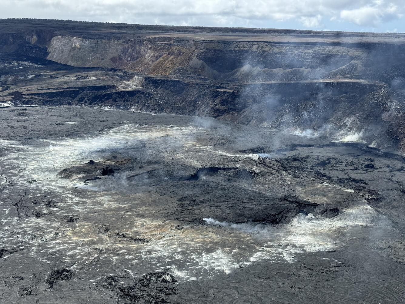
Hawaii , Kilauea :
Monday, September 9, 2024, 9:06 AM HST (Monday, September 9, 2024, 19:06 UTC)
19°25’16 » N 155°17’13 » W,
Summit Elevation 4091 ft (1247 m)
Current Volcano Alert Level: ADVISORY
Current Aviation Color Code: YELLOW
Activity Summary:
Kīlauea is not erupting. Earthquake activity in Kīlauea’s upper East Rift Zone (UERZ) has been low over the last 24 hours. Changes in the character and location of unrest can occur quickly, as can the potential for eruption, but there are no signs of imminent eruption at this time. There are no significant changes in activity in the lower East Rift Zone or Southwest Rift Zone.
Summit Observations:
Approximately 7 earthquakes were detected beneath Kaluapele (Kīlauea’s summit caldera) over the past 24 hours at depths of 1–3 km (0.6–1.9 mi) below the ground surface, most with magnitudes of less than M2.0. Rates of deformation at the summit remained relatively low, with slightly fluctuating tilt at summit tiltmeters over the past day. An overall gradual inflationary trend has been measured by GPS instruments around the summit region in recent months. The most recent measurement of the summit’s SO2 emission rate was approximately 75 tonnes per day on August 20, 2024.
Rift Zone Observations:
Over the past 24 hours, there have been approximately 5 earthquakes beneath Kīlauea’s UERZ region, extending from Puhimau Crater southeast to Maunaulu, a decrease from yesterday. Most earthquakes have been smaller than M2.0. Events have remained at depths of 1–3 km (0.6–1.8 miles) beneath the surface. Currently, deformation remains stable over the past 24 hours.
Activity in the middle East Rift Zone (MERZ) remains low. There were no significant changes in the POC tiltmeter over the past day. GPS instruments have recorded overall inflation in the region over the past month.
Measurements from continuous gas monitoring stations downwind of Puʻuʻōʻō in the middle East Rift Zone—the site of 1983–2018 eruptive activity—remain below detection limits for SO2, indicating that SO2 emissions from this area are negligible.
At this time, there is no evidence of elevated seismicity or ground deformation beneath the lower East Rift Zone, and Southwest Rift Zone activity remains low. Current activity is restricted to the summit and upper East Rift Zone region.
Source : HVO
Photo : USGS M. Patrick. ( 05/2024).
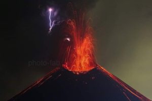
Guatemala , Fuego :
Weather conditions: Clear.
Wind: Southeast.
Precipitation: 32.6 mm.
Activity:
5 to 7 weak to moderate explosions are recorded per hour, with columns of gas and ash rising up to 4,700 meters (15,419 feet) and dispersing over 10 to 30 km in a west and northwest direction. The explosions are accompanied by avalanches that descend on different sides of the volcano and produce a noise similar to that of aircraft turbines for 1 to 2 minutes.
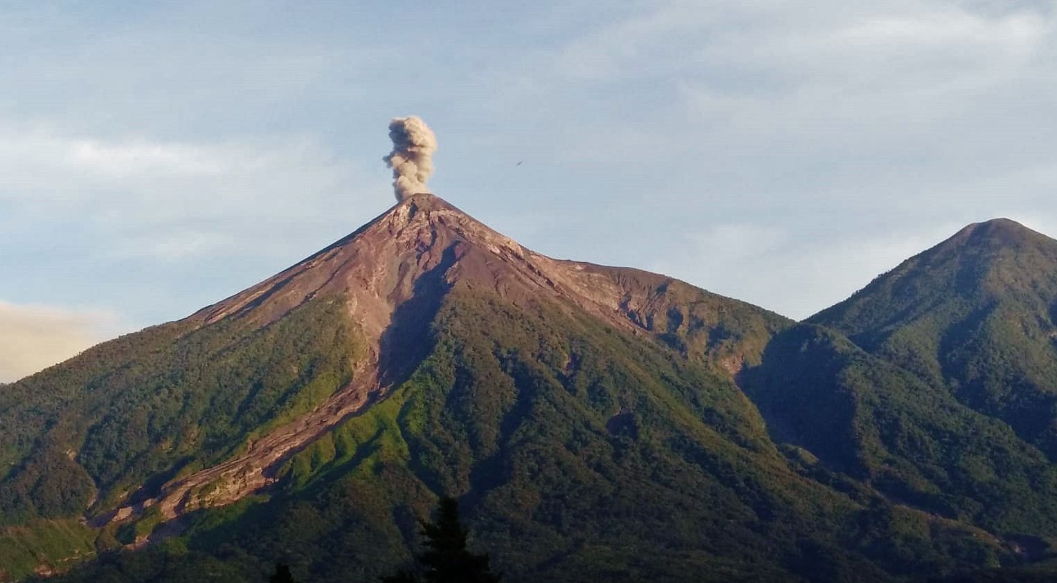
Likewise, during the night and early in the morning, incandescent pulses are observed that reach 100 meters in height above the crater. Fine ash falls are expected in the cities located to the west of the volcano, such as Yepocapa and Acatenango. Regarding explosive activity, follow the recommendations described in the special bulletin BEFGO-003-2024.
Source : Insivumeh.
Photo : Conred via facebook ( 2022) .