September 06 , 2024 .
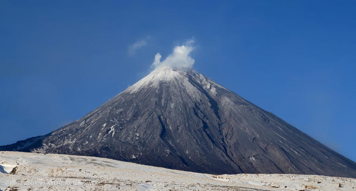
Kamchatka , Klyuchevskoy :
A sudden increase in seismicity at Klyuchevskoy during 1-3 September prompted KVERT to raise the Aviation Color Code to Yellow (the second lowest level on a four-color scale) at 0822 on 4 September. Dates and times are in UTC; specific events are in local time where noted.
VOLCANO OBSERVATORY NOTICE FOR AVIATION (VONA)
Issued: September 04 , 2024
Volcano: Klyuchevskoy (CAVW #300260)
Current aviation colour code: YELLOW
Previous aviation colour code: green
Source: KVERT
Notice Number: 2024-69
Volcano Location: N 56 deg 3 min E 160 deg 38 min
Area: Kamchatka, Russia
Summit Elevation: 4750 m (15580 ft)
Volcanic Activity Summary:
According to the sharp increase in seismicity of the volcano during 01-03 September, a lateral break (a flank eruption) is possible on the northern slope of the Klyuchevskoy volcano during the next two weeks with the removal of ash up to 8 km a.s.l. and the effusing of lava flows.
An activity of the volcano continues. Ash explosions up to 8 km (26,200 ft) a.s.l. could occur at any time. Ongoing activity could affect international and low-flying aircraft.
Volcanic cloud height:
NO ASH CLOUD PRODUSED
Other volcanic cloud information:
NO ASH CLOUD PRODUSED
Source : KVERT , GVP.
Photo : Yu. Demyanchuk, IVS FEB RAS, KVERT ( 11/2023)
Japan , Satsuma Iwo-jima / Kikai :
JMA reported that an eruptive event at Iodake Crater located at Satsuma Iwo-jima, a subaerial part of Kikai’s NW caldera rim, was recorded at 1128 on 1 September. An ash plume rose 1 km above the crater rim. The report noted that there was no change in the number of earthquakes either before or after the event, and no volcanic tremors were recorded. An eruptive event at 1008 on 3 September generated a volcanic plume that rose 700 m above the crater rim. Crater incandescence continued to be observed at night. The 1 September event was the first eruptive activity since 6 October 2020. The Alert Level remained at 2 (on a 5-level scale), and residents were warned to stay 500 m away from Iodake Crater.
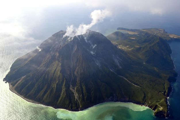
Multiple eruption centers have exhibited recent activity at Kikai, a mostly submerged, 19-km-wide caldera near the northern end of the Ryukyu Islands south of Kyushu. It was the source of one of the world’s largest Holocene eruptions about 6,300 years ago when rhyolitic pyroclastic flows traveled across the sea for a total distance of 100 km to southern Kyushu, and ashfall reached the northern Japanese island of Hokkaido. The eruption devastated southern and central Kyushu, which remained uninhabited for several centuries. Post-caldera eruptions formed Iodake (or Iwo-dake) lava dome and Inamuradake scoria cone, as well as submarine lava domes. Recorded eruptions have occurred at or near Satsuma-Iojima (also known as Tokara-Iojima), a small 3 x 6 km island forming part of the NW caldera rim. Showa-Iojima lava dome (also known as Iojima-Shinto), a small island 2 km E of Satsuma-Iojima, was formed during submarine eruptions in 1934 and 1935. Mild-to-moderate explosive eruptions have occurred during the past few decades from Iodake, a rhyolitic lava dome at the eastern end of Satsuma-Iojima.
Sources : Japan Meteorological Agency (JMA) , GVP.
Photo : The Asahi Shimbun ( 11/2022) .
Iceland , Reykjanes Peninsula :
Measurements indicate that uplift has resumed in Svartsengi . The eruption has significantly weakened
Updated 5. September at 15:00 UTC
The intensity of the eruption continues to weaken
GPS measurements indicate that uplift at Svartsengi has resumed
Southwesterly winds are present at the eruption site, with a speed of 13-20 m/s. Air pollution from volcanic gas may be detected in Vatnsleysa and the capital area
The hazard assessment remains mostly unchanged
The activity of the eruption has continued to decrease in recent days. However, two eruptive vents still appear to be active. The lava field north of the eruption site continues to thicken and expand slowly to the north. At this point, the active lava flow does not threaten infrastructure near the eruption site. Furthermore, changes in volcanic tremor and gas emissions indicate that the eruption has diminished significantly in recent days.
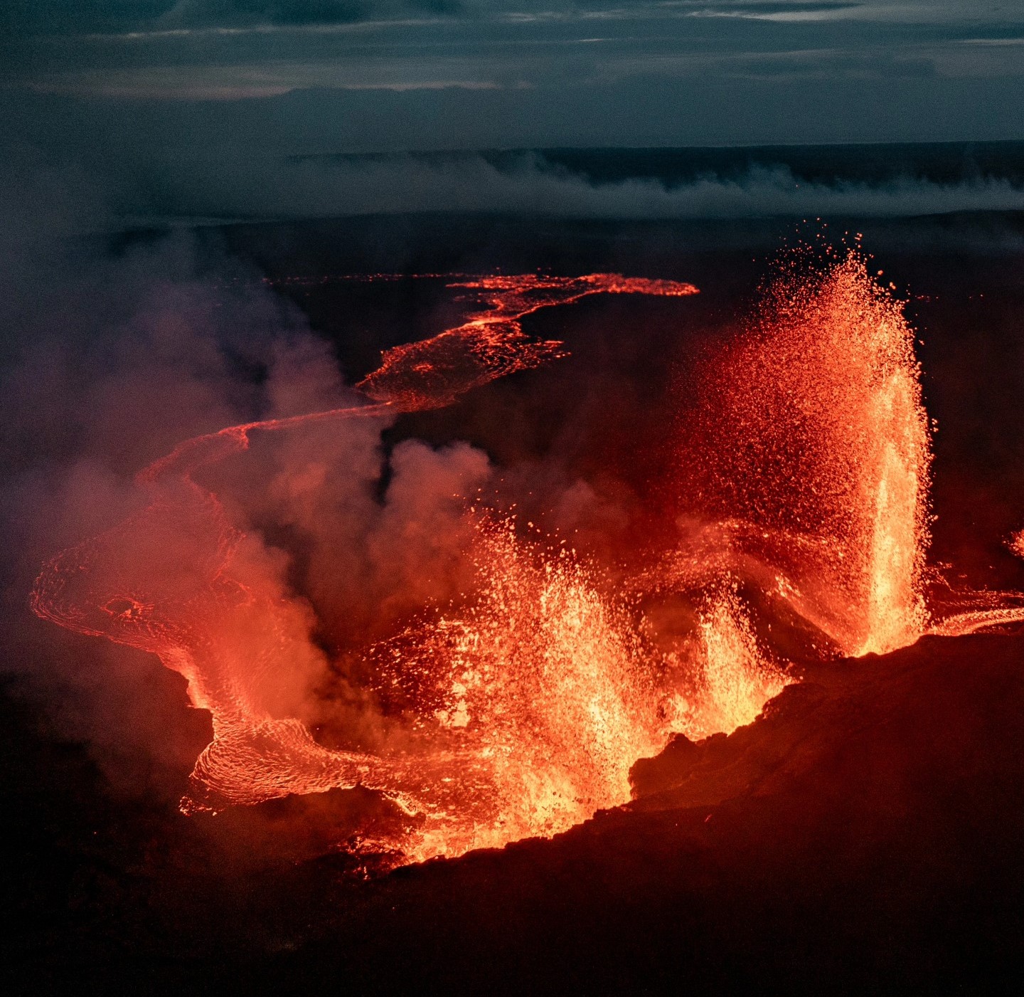
GPS measurements suggest that ground uplift has started again in Svartsengi. Meanwhile, the amount of lava extruded in the eruption at the Sundhnúkur crater row has decreased. This suggests that the influx of magma into the reservoir beneath Svartsengi is greater than the outflow from the surface eruption. This development is similar to what was observed after the last eruption began on May 29. In that instance, the uplift at Svartsengi became noticeable approximately two weeks after the eruption started.
Seismic activity has slowed since the eruption began on August 22. In recent days, the activity has decreased further, with very little earthquake activity recorded. However, strong winds can affect the sensitivity of the seismic monitoring system, preventing small earthquakes from being detected.
The hazard assessment remains mostly unchanged, except that the risk from volcanic ash is now considered lower. The map is valid until September 10, barring any changes.
Source : IMO.
Photo : Jakob Vegerfors / FB.
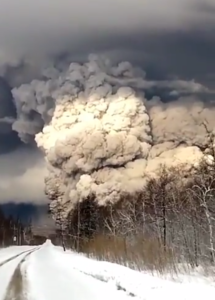
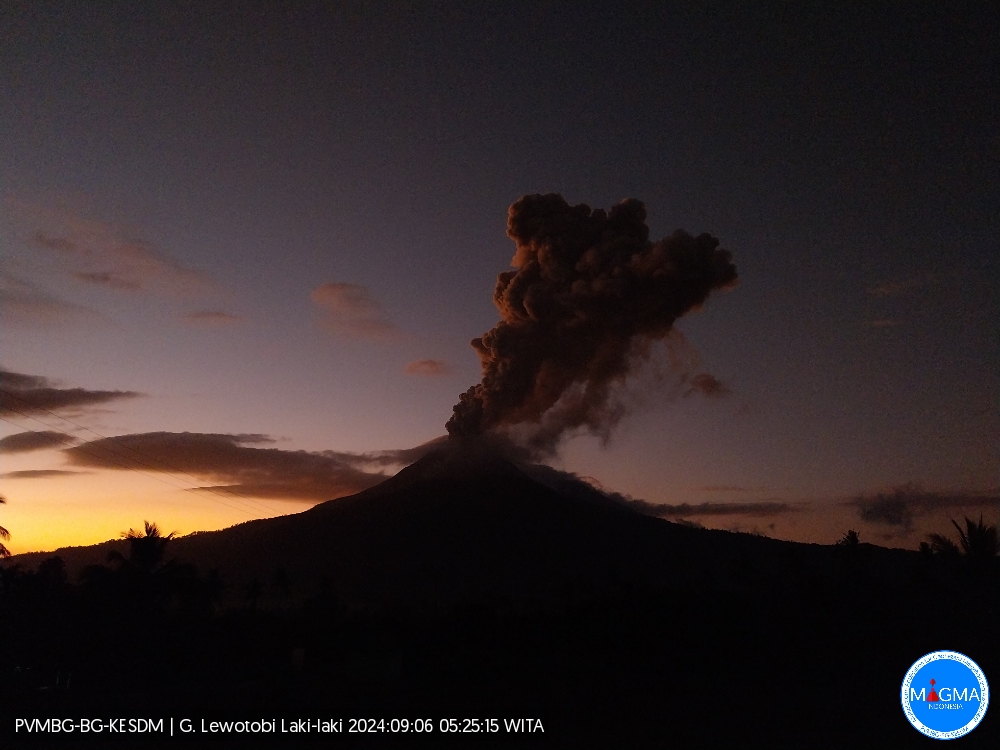
Indonesia , Lewotobi Laki-laki :
An eruption of Lewotobi Laki occurred on Friday, September 6, 2024 at 05:19 WITA with the height of the ash column observed at ± 700 m above the summit (± 2284 m above sea level). The ash column was observed to be gray in color with a thick intensity, oriented towards the Southwest. This eruption was recorded on a seismograph with a maximum amplitude of 14 mm and a duration of 587 seconds.
VOLCANO OBSERVATORY NOTICE FOR AVIATION – VONA
Issued : September 06 , 2024
Volcano : Lewotobi Laki-laki (264180)
Current Aviation Colour Code : ORANGE
Previous Aviation Colour Code : orange
Source : Lewotobi Laki-laki Volcano Observatory
Notice Number : 2024LWK460
Volcano Location : S 08 deg 32 min 20 sec E 122 deg 46 min 06 sec
Area : East Nusa Tenggara, Indonesia
Summit Elevation : 5069 FT (1584 M)
Volcanic Activity Summary :
Eruption with volcanic ash cloud at 21h19 UTC (05h19 local).
Volcanic Cloud Height :
Best estimate of ash-cloud top is around 7309 FT (2284 M) above sea level or 2240 FT (700 M) above summit. May be higher than what can be observed clearly. Source of height data: ground observer.
Other Volcanic Cloud Information :
Ash cloud moving to southwest. Volcanic ash is observed to be gray. The intensity of volcanic ash is observed to be thick.
Remarks :
Eruption recorded on seismogram with maximum amplitude 14 mm and maximum duration 587 second.
Source et photo : Magma Indonésie.
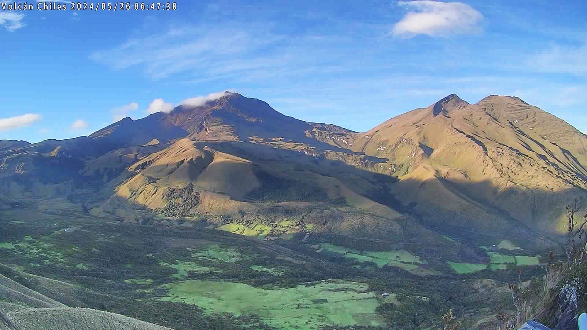
Colombia , Chiles / Cerro Negro :
San Juan de Pasto, September 3, 2024, 4:30 p.m.
From the monitoring of the activity of the Chiles and Cerro Negro volcanoes, the Colombian Geological Survey (SGC), an entity attached to the Ministry of Mines and Energy, reports that:
During the week of August 27 to September 2, 2024, the activity of these volcanoes showed variations in the records, which can be considered as part of a stable behavior. Compared to the previous week, the main variations in the monitored parameters were:
• There was a decrease in both the number of earthquakes and the energy released.
• The predominance of seismicity associated with rock fractures within the volcanic system was maintained.
• Earthquakes related to fracture processes were located mainly in the collapse zone of the Chiles volcano, at depths between 2 km and 4 km from the summit (4,700 m) and magnitudes less than 1. Other events were located scattered, at distances less than 13 km, with depths between 4 and 12 km from its summit, with a maximum magnitude of 2.
• The recording of seismicity related to the movement of fluids inside these volcanoes has persisted; some of these events with very low frequency content, which represent the largest energy contribution of the week.
• Field deformation sensors and remote satellite sensors have continued to record changes associated with an inflationary process in the volcanic area.
Based on the above, the SGC recommends closely monitoring the evolution through the weekly bulletins and other information published through our official channels, as well as the instructions of local and departmental authorities and the National Disaster Risk Management Unit (UNGRD).
Volcanic activity remains in yellow alert status: active volcano with changes in the behavior of the base level of the monitored parameters and other manifestations.
Source et photo : SGC.