September 05 , 2024.
Kamchatka , Sheveluch :
VOLCANO OBSERVATORY NOTICE FOR AVIATION (VONA)
Issued: September 05 , 2024
Volcano: Sheveluch (CAVW #300270)
Current aviation colour code: ORANGE
Previous aviation colour code: orange
Source: KVERT
Notice Number: 2024-70
Volcano Location: N 56 deg 38 min E 161 deg 18 min
Area: Kamchatka, Russia
Summit Elevation: 3283 m (10768.24 ft), the dome elevation ~2500 m (8200 ft)
Volcanic Activity Summary:
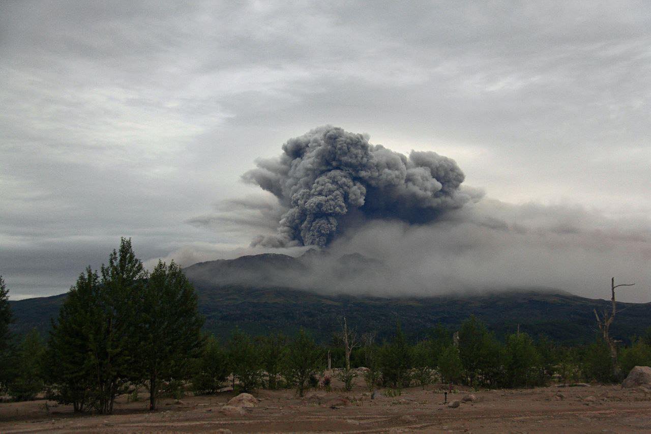
Video and satellite data by KVERT shows a strong wind lifts ash from the southern slopes of the Sheveluch volcano up to 2.5 km a.s.l., and a plume of resuspended ash is extending about 82 km to the east of the volcano.
An explosive-extrusive eruption of Sheveluch volcano continues. The danger of ash explosions up to 10 km (32,800 ft) a.s.l. remains. Ongoing activity could affect international and low-flying aircraft.
Volcanic cloud height:
2000-2500 m (6560-8200 ft) AMSL Time and method of ash plume/cloud height determination: 20240905/0225Z – Video data
Other volcanic cloud information:
Distance of ash plume/cloud of the volcano: 82 km (51 mi)
Direction of drift of ash plume/cloud of the volcano: E / azimuth 97 deg
Time and method of ash plume/cloud determination: 20240905/0140Z – Himawari-9 14m15
Remarks: an resuspended ash
Source : Kvert
Photo : Viktor Frolov , Institut de volcanologie et de sismologie DVO RAN, @IViS_DVO_RAN ( 08/2024)
Indonesia , Tangkuban Parahu :
Forest fire on Tangkuban Parahu, September 4, 2024.
Mount Tangkuban Parahu is an active volcano. Eruptions from Mount Tangkuban Parahu usually take the form of phreatic eruptions from the crater.
The last increase in volcanic activity at Mount Tangkuban Parahu occurred in 2019. Continuous eruptive activity was observed until August 9, 2019.
On September 4, 2024, residents raised many questions regarding the appearance of thin to thick white smoke around Tangkuban Parahu. The community was concerned that the appearance of the smoke was related to volcanic activity at Mount Tangkuban Parahu. Based on this information, Tangkuban Parahu observers immediately verified the observation data and information for stakeholders around Tangkuban Parahu Nature Tourism Park.
Based on the results of visual and instrumental monitoring, as well as verification of information with stakeholders, the following data were obtained:
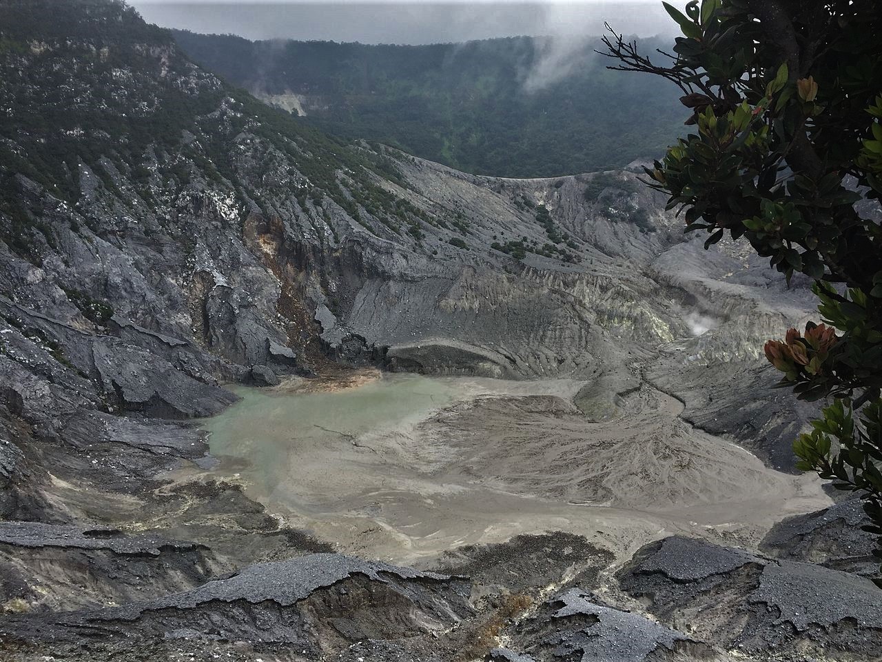
On Wednesday, September 4, 2024, at around 01:41 WIB, from the CCTV camera monitoring the activity of Tangkuban Parahu, a light could be seen located above the new crater (near Upas Hills). The appearance of thin white smoke was monitored by CCTV cameras at 05:51 and 09:20. At 11:30, according to information from the Tourism Manager (PT GRPP) and local residents, a forest fire had occurred in the same location according to CCTV observations. So far, efforts to extinguish the fire by the community and relevant parties are still ongoing. This fire did not disturb the Tangkuban Parahu Volcano Monitoring Station because it was located far from the fire site. By visually monitoring the conditions of Ratu Crater and Ecoma Crater on September 4, 2024 at 14:27 WIB, there were no visible anomalies in the smoke escape from the crater compared to previous observations.
The volcanic activity of Tangkuban Parahu until September 4, 2024, in terms of seismicity, is still dominated by low-frequency earthquakes that indicate fluid movement activity at shallow depths or near the surface. At the same time, the type of volcanic tremor associated with magma input did not show a significant level of occurrence (on average, it occurs less than one event per day).
The results of deformation monitoring with an inclinometer and electronic distance measuring (EDM) equipment this month did not show any significant trend of additional pressure below the surface in response to the swelling of the Tangkuban Parahu mountain body.
Based on the results of visual and instrumental assessments, the activity level of Mount Tangkuban Parahu until September 4, 2024 16:00 WIB is still at Level I (normal).
Source : PVMBG
Photo : Adri45an ( 02/2022)
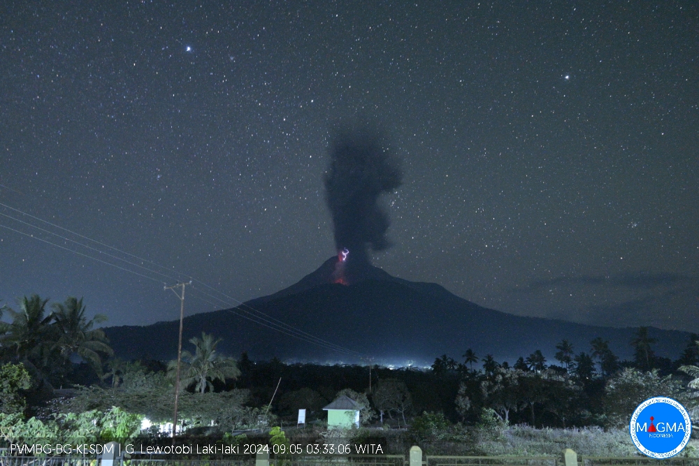
Indonesia , Lewotobi Laki-laki :
An eruption of Lewotobi Laki-laki occurred on Thursday, September 5, 2024 at 03:31 WITA with the height of the ash column observed at ± 800 m above the summit (± 2384 m above sea level). The ash column was observed to be gray in color with a thick intensity, oriented towards the northwest. This eruption was recorded on a seismograph with a maximum amplitude of 22 mm and a duration of 177 seconds.
VOLCANO OBSERVATORY NOTICE FOR AVIATION – VONA
Issued : September 5 , 2024
Volcano : Lewotobi Laki-laki (264180)
Current Aviation Colour Code : ORANGE
Previous Aviation Colour Code : orange
Source : Lewotobi Laki-laki Volcano Observatory
Notice Number : 2024LWK454
Volcano Location : S 08 deg 32 min 20 sec E 122 deg 46 min 06 sec
Area : East Nusa Tenggara, Indonesia
Summit Elevation : 5069 FT (1584 M)
Volcanic Activity Summary :
Eruption with volcanic ash cloud at 19h31 UTC (03h31 local).
Volcanic Cloud Height :
Best estimate of ash-cloud top is around 7629 FT (2384 M) above sea level or 2560 FT (800 M) above summit. May be higher than what can be observed clearly. Source of height data: ground observer.
Other Volcanic Cloud Information :
Ash cloud moving to northwest. Volcanic ash is observed to be gray. The intensity of volcanic ash is observed to be thick.
Remarks :
Eruption recorded on seismogram with maximum amplitude 22 mm and maximum duration 177 second.
Source et photo : Magma Indonésie.
Colombia , Nevado del Ruiz :
Manizales, September 3, 2024, 7:30 p.m.
From the monitoring of the activity of the Nevado del Ruiz volcano, the Colombian Geological Survey (SGC), an entity attached to the Ministry of Mines and Energy, reports that:
During the week of August 27 to September 2, 2024, the volcano continued with unstable behavior. Compared to the previous week, the main variations in the monitored parameters were:
– The seismic activity associated with the fracturing of rocks inside the volcanic edifice decreased in the number of earthquakes recorded and maintained similar levels in the seismic energy released. The earthquakes were located in the Arenas crater and on the different flanks of the volcano, mainly in the northeast and north sectors, at distances of less than 8 km from the crater. The depths of the events varied between less than 1 km and 6 km from the summit of the volcano. The highest magnitude of the week was 1.7, corresponding to the earthquake recorded on August 30 at 19:42 in the Arenas crater, at a depth of 2 km. Seismic activity related to the activity of the lava dome (protuberance or mound) located at the bottom of the crater continued to be recorded occasionally at low energy levels.

– Seismicity related to the activity of fluids inside volcanic conduits decreased in the number of earthquakes recorded and in the seismic energy released. This decrease was particularly visible in long-period signals. The energy levels of the seismic signals varied between low and moderate values, and sometimes they presented high values. Several changes in the temperature of the emitted material, associated with some of these seismic events, were observed in FLIR (thermographic) cameras. Thanks to the cameras used to monitor the volcano and the reports of the managers of the Los Nevados National Natural Park and the inhabitants of the volcanic influence zone, it was possible to confirm several ash emissions.
– On the volcano, the emission of water vapor and gases into the atmosphere from the Arenas crater continues. The degassing rates of sulfur dioxide (SO₂) were variable, with values slightly lower than those recorded the previous week. On August 30, the gas column reached a maximum vertical height of 1,300 m and a dispersion height of 2,300 m. These values were estimated above the volcanic summit during the ash emission recorded at 1:38 p.m. The dispersion direction of the gas column maintained a preferential trend towards the West-Northwest and Northwest of the volcano. In accordance with this dispersion direction, reports of ash fall were received in the sectors near the volcano and in the municipalities of Manizales and Villamaría, in the department of Caldas, especially on August 27 and 31.
– When monitoring thermal anomalies at the bottom of the Arenas crater, from satellite monitoring platforms, their detection continues to be limited by the atmospheric conditions prevailing in the area. During the week, only two low-energy anomalies were reported.
Source et photo : SGC
La Réunion , Piton de la Fournaise :
Seismicity
In August 2024, the OVPF-IPGP recorded in the Piton de la Fournaise massif in total:
• 15 superficial volcano-tectonic earthquakes (0 to 2.5 km above sea level) under the summit craters;
• 4 deep earthquakes (below sea level);
• 19 long-period earthquakes;
• 110 landslides.
The month of August 2024 was marked by low seismicity under the Piton de la Fournaise with only 15 superficial volcano-tectonic earthquakes and 4 deep earthquakes recorded.
Only 3 superficial volcano-tectonic earthquakes and 1 deep earthquake could be located respectively under the Dolomieu crater and the eastern flank. The others – of lower magnitudes – could not be located.
Numerous (110) landslides in the Dolomieu Crater, at the level of the ramparts of the Enclos Fouqué and at the Cassé de la Rivière de l’Est were also recorded.
Phenomenology
No eruptive activity during the month of August 2024.
Summary
Since April 2024, magma replenishment and pressurization of the superficial reservoir have ceased.
In August 2024, seismicity remained low – with only 15 superficial and 4 deep volcano-tectonic earthquakes recorded under the summit craters.
Note that since 2016, replenishment of the superficial magmatic reservoir under the Piton de la Fournaise has been done in pulses, so such phases of calm in deformations and seismicity have already been observed several times between 2016 and 2023 over periods ranging from 15 days to several months.
Source : OVPF / https://www.ipgp.fr/communiques-et-bulletins-de-lobservatoire/?categorie=&domaine=&date=&observatoire-associe=391&motcle=
Photo : Tunnels de lave Réunion : Rando-Volcan ( 04/2023)