September 03 , 2024.
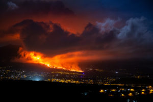
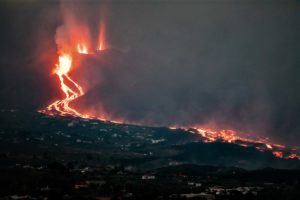
Iceland : Reykjanes Peninsula :
Two jets still the most active.
Two jets are still the most active in the volcanic eruption at Sundhnúkagígar crater row, and lava continues to accumulate around there.
This is what Sigríður Kristjánsdóttir, a natural disaster expert at the Icelandic Meteorological Office, says when asked about the situation.
She says there have been little changes in the eruption in the last few days. Visibility has decreased in the area, but it was nice last night.
Slight air pollution has been observed in Vogar this morning and it can be expected that it will continue there from the beginning of the day. The afternoon might slow her down.
There has been very little seismic activity at the craters and five earthquakes have been recorded there in the last 24 hours.
Crater rims growing – Land deformation continues.
Considerable magma activity remains in two craters north of the fissure in the Sundhnúkagígar crater row. The craters are very close to each other and the rims are gradually growing.
The activity is similar to what has been happening recently, according to Bjarki Kaldalón Friis, a natural disaster expert at the Icelandic Meteorological Office.
There has been little seismic activity in the magma tunnel and the land has continued to sink because the magma chamber is emptying. The Met Office’s GPS meters show this.
No air pollution is measured now, as the wind is light. According to Friis, the wind is north and the smoke therefore blows out to sea. The afternoon of today and tonight turns to the west, and then pollution could cross over Southland.
Wildfires also do not seem to have been large during the night in the area of the eruption.
Source : Iceland monitor .
Photo : mbl.is/Árni Sæberg
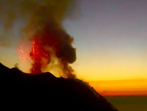
Indonesia , Lewotobi Laki-laki :
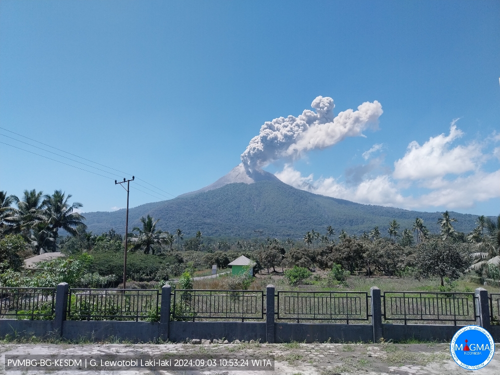
An eruption of Lewotobi Laki Laki occurred on Tuesday, September 3, 2024, at 10:49 WITA with the height of the ash column observed at ± 600 m above the summit (± 2184 m above sea level). The ash column was observed to be gray in color with a thick intensity, oriented towards the Southwest. This eruption was recorded on a seismograph with a maximum amplitude of 5.92 mm and a duration of 314 seconds.
VOLCANO OBSERVATORY NOTICE FOR AVIATION – VONA
Issued : September 03 , 2024
Volcano : Lewotobi Laki-laki (264180)
Current Aviation Colour Code : ORANGE
Previous Aviation Colour Code : orange
Source : Lewotobi Laki-laki Volcano Observatory
Notice Number : 2024LWK450
Volcano Location : S 08 deg 32 min 20 sec E 122 deg 46 min 06 sec
Area : East Nusa Tenggara, Indonesia
Summit Elevation : 5069 FT (1584 M)
Volcanic Activity Summary :
Eruption with volcanic ash cloud at 02h49 UTC (10h49 local).
Volcanic Cloud Height :
Best estimate of ash-cloud top is around 6989 FT (2184 M) above sea level or 1920 FT (600 M) above summit. May be higher than what can be observed clearly. Source of height data: ground observer.
Other Volcanic Cloud Information :
Ash cloud moving to southwest. Volcanic ash is observed to be gray. The intensity of volcanic ash is observed to be thick.
Remarks :
Eruption recorded on seismogram with maximum amplitude 5.92 mm and maximum duration 314 second.
Source et photo : Magma Indonésie.
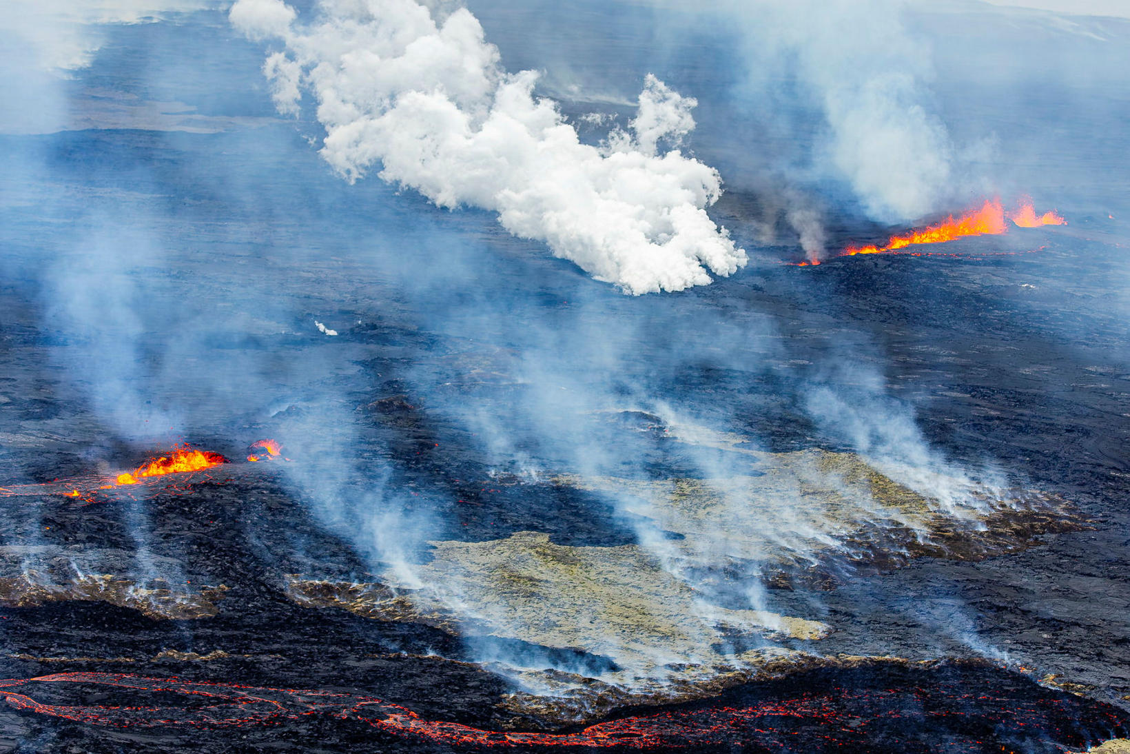
Hawaii , Kilauea :
Monday, September 2, 2024, 9:01 AM HST (Monday, September 2, 2024, 19:01 UTC)
19°25’16 » N 155°17’13 » W,
Summit Elevation 4091 ft (1247 m)
Current Volcano Alert Level: ADVISORY
Current Aviation Color Code: YELLOW
Activity Summary:
Kīlauea is not erupting. Earthquake activity remains elevated in Kīlauea’s upper East Rift Zone (UERZ). Changes in the character and location of unrest can occur quickly, as can the potential for eruption, but there are no signs of imminent eruption at this time. There are no significant changes in activity in the lower East Rift Zone and Southwest Rift Zone.
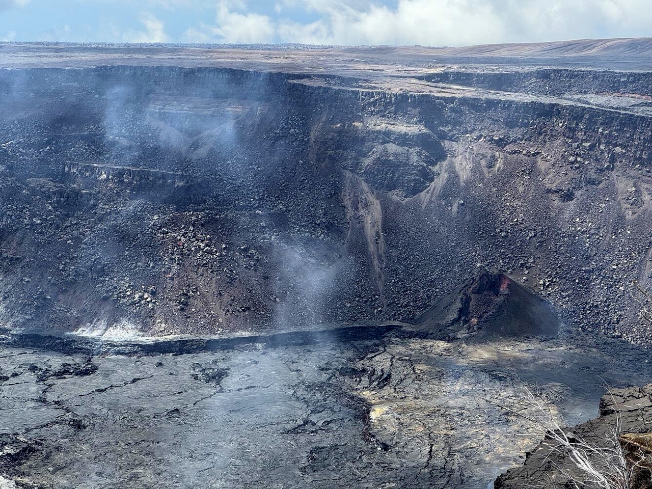
Summit Observations:
Approximately 24 earthquakes were detected beneath Kaluapele (Kīlauea’s summit caldera) over the past 24 hours at depths of 1–3 km (0.6–1.9 mi) below the ground surface, most with magnitudes of less than M2.0. Rates of deformation at the summit remained relatively low, with fluctuating tilt at summit tiltmeters over the past day. An overall gradual inflationary trend continues to be seen on GPS instruments around the summit region. The most recent measurement of the summit’s SO2 emission rate was approximately 75 tonnes per day on August 20, 2024.
Rift Zone Observations:
Over the past 24 hours, there have been approximately 62 earthquakes beneath Kīlauea’s UERZ region, extending from Puhimau Crater southeast to Maunaulu. Most earthquakes have been smaller than M2.0. Events have remained at depths of 1–3 km (0.6–1.8 miles) beneath the surface. Currently, deformation remains stable over the past 24 hours.
Activity in the middle East Rift Zone (MERZ) remains low. There were no significant changes in the POC tiltmeter over the past day. GPS instruments have recorded overall inflation in the region over the past month.
Measurements from continuous gas monitoring stations downwind of Puʻuʻōʻō in the middle East Rift Zone—the site of 1983–2018 eruptive activity—remain below detection limits for SO2, indicating that SO2 emissions from this area are negligible.
At this time, there is no evidence of elevated seismicity or ground deformation beneath the lower East Rift Zone, and Southwest Rift Zone activity remains low. Current activity is restricted to the summit and upper East Rift Zone region.
Source : HVO
Photo : USGS/ M. Patrick. (05/2024).
Vanuatu , Yasur :
19°32’0”S 169°26’30”E
Summit 1184ft (361m)
Current Volcano Alert Level: Level 2
Yasur volcano is continuing in the major unrest state. Yasur Volcanic Alert Level remains at Level 2.
Major volcanic unrest at Yasur continues and confined inside the volcanic crater. New field observations and data analysis confirmed that Yasur volcano condition at this major unrest state remain unstable. Its volcanic activity is likely to continue at this similar level, consistent with Volcanic Alert Level 2. The danger zone for life safety remain limited at 600 m radius from eruptive vents inside Yasur crater.
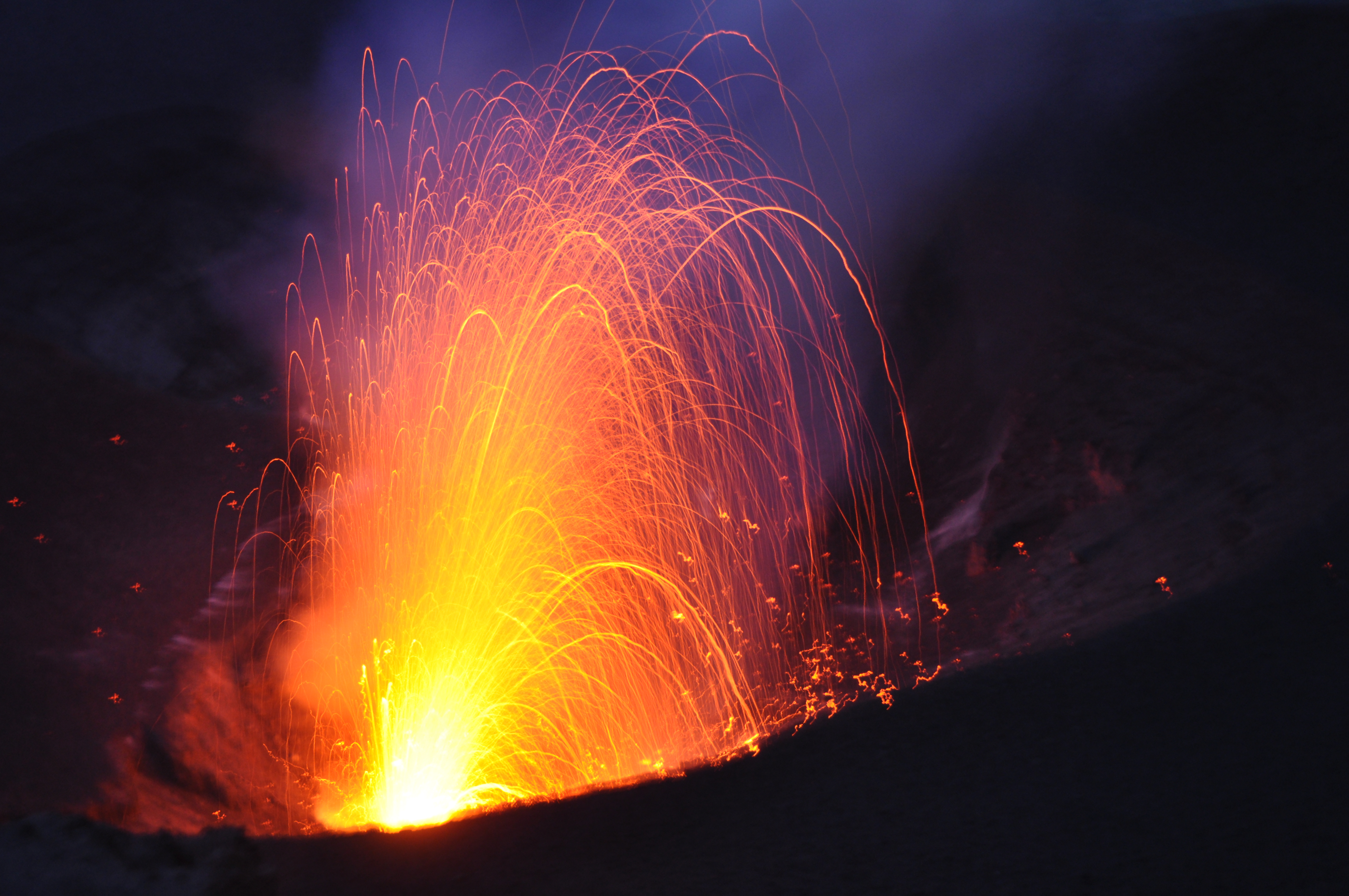
Recent field observation photos via webcam shown that Yasur volcanic activity consists of continuous explosions with cloud emissions that may contain water vapor (steam) and/or gases and/or ashes from eruptive vents. Satellite images of the past days have confirmed evidence of volcanic degassing and low to moderate thermal anomalies detection at Yasur. Presence of thermal anomalies shows the exposure of magma at the earth surface. Major volcanic unrest activity continue at Yasur and some explosions remain strong. Volcanic bombs may fall in and/or around the crater rim. With this activity, volcanic hazards remain inside the crater and in the caldera.
Source : Geohazard
Photo : G Vitton (2015)
Guatemala , Santiaguito :
Atmospheric conditions: Cloudy.
Wind: Northeast.
Precipitation: 45.4 mm.
Activity:
Cloudy conditions allow partial observation of volcanic activity. Activity is reported in the Caliente Dome of the Santa María-Santiaguito volcanic complex, characterized by weak to moderate explosions that raise columns of ash and gas to heights of up to 700 meters above the dome, which move towards the West and Southwest following the wind direction.
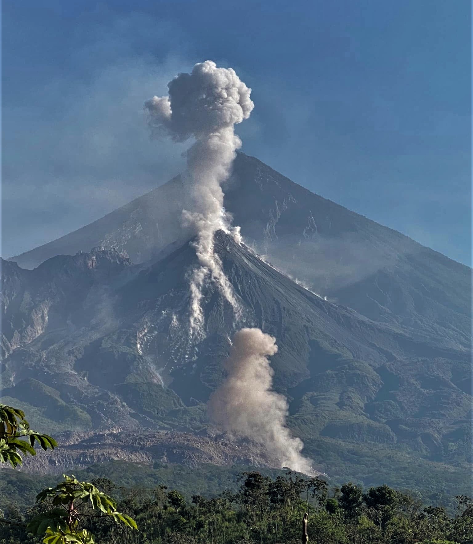
These explosions are accompanied by low noises of degassing, similar to those of an airplane turbine. The Santiaguito Volcano Observatory (OVSAN) reports noises caused by the collapse and descent of materials from the Caliente Dome. During the afternoon and evening, rains could cause lahars to descend into the channels descending from the Caliente Dome. The activity remains at a high level, so there is the possibility that, due to explosions or under the effect of gravity, part of the accumulated material will collapse and generate pyroclastic flows over long distances towards the southwest, south and southeast.
Source : Insivumeh .
Photo : Armando Pineda ( 02/2023).