August 30 , 2024.
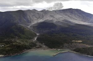
Iceland : Reykjanes Peninsula :
Volcanic eruption activity has been fairly stable over the past few days. Land uplift is still being measured at Svartsengi. The magma chamber is emptying faster than magma is entering it.
Updated 29 August at 16:50
Over the past few days, the volcano activity has remained fairly constant
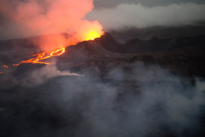
Lava is flowing mainly to the northwest, but also to the east
Land uplift is still being measured at Svartsengi. The magma chamber is emptying faster than magma is entering it
More seismic activity after the eruption than during previous eruptions. About 20 earthquakes during the last day.
Current gas distribution forecast is to the northwest and gas pollution is heading to the southeast.
Updated risk assessment
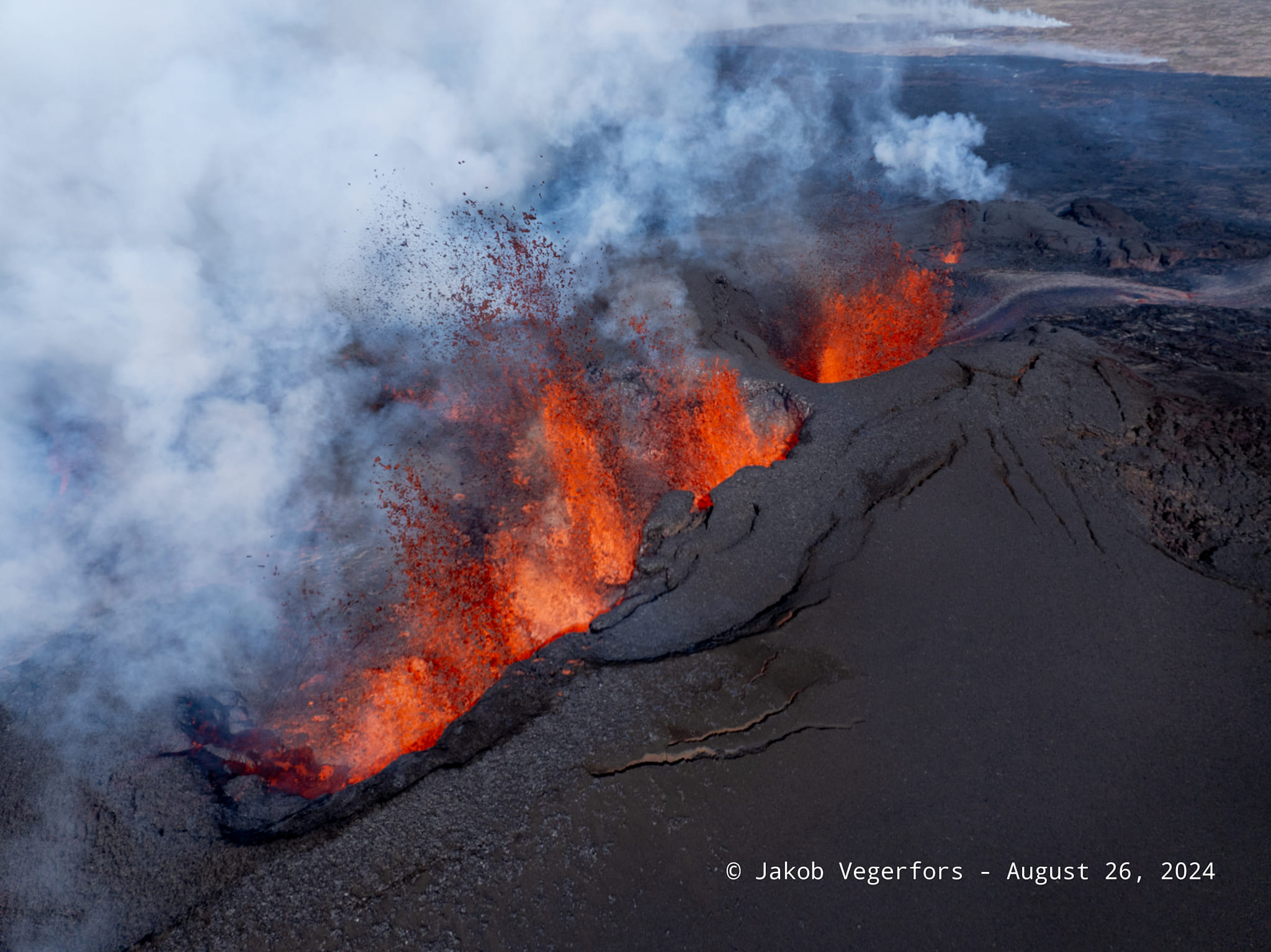
The eruption continues in the area northeast of Stóra-Skógfell. Over the past few days, the activity has been fairly constant. There are two active main jets that are quite powerful to see. The lava continues to flow mainly northwest but also east. The main flow is northwest, but its progression is very slow.
More seismic activity is measured after the eruption began on August 22nd than in previous eruptions in the area. This is probably because it is now in the north and will release more tension than in the south where it erupted before. About 20 earthquakes have been recorded in the magma tunnel in the past 24 hours and 110 earthquakes since Monday, August 26th. Mostly confined to the active eruption area.
There is still some uplift at Svartsengi, but it is slowing down. This is a very similar trend to the last eruption. The magma chamber is therefore always emptying faster than the magma is entering it.
The gas dispersion expected today, Thursday August 29, is 3 to 8 m/s towards the North-West and the gas pollution is heading towards the South-East.
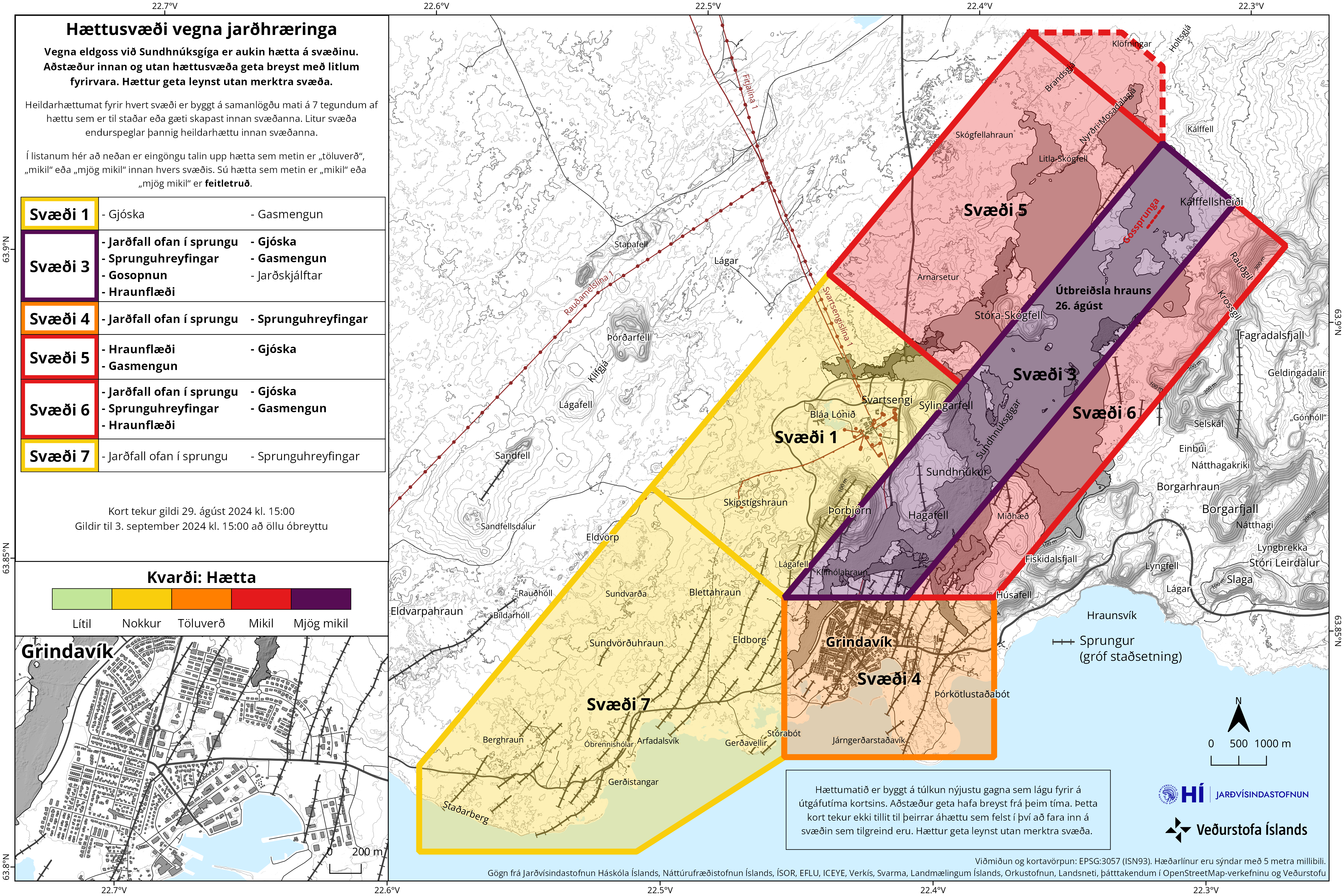
Updated risk assessment
The risk assessment has been updated and remains valid until 3 September. The main changes are in zone 1, which goes from considerable risk (orange) to definite risk (yellow). The change is made taking into account the reduced risk from lava flows, gas contamination and pyroclastic emissions. Less gas pollution also affects zones 4 (Grindavík) and 7 according to the gas distribution forecast for the coming days. The area inside the fracture line in zone 5 probably represents the evolution of the lava after several days.
Source : IMO
Photos : Jakob Vegerfors / FB , IMO.
Italy , Stromboli :
Statement on the activity of Stromboli, 30 August 2024, 03:51 (01:51 UTC)
The National Institute of Geophysics and Volcanology, Osservatorio Etneo, communicates from the surveillance cameras, from about 01:20 UTC, a lava overflow is observed in the Sciara del Fuoco, fed by an intense activity of projections in the area of the North crater. Currently, the lava front is located at an altitude between 500 and 400 m above sea level. At the same time, explosive activity continues from the North area of the crater.
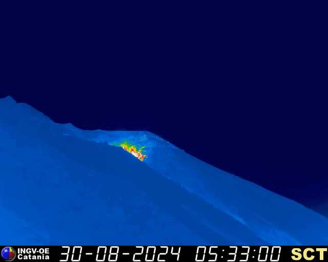
From a seismic point of view, the average amplitude of volcanic tremors is currently at very high levels. No significant changes have been reported in the frequency of occurrence and amplitude of explosion earthquakes. The inclinometric data from Timpone del Fuoco and the high-frequency GNSS data do not show significant variations.
Further updates will be communicated shortly.
Source et photo : INGV
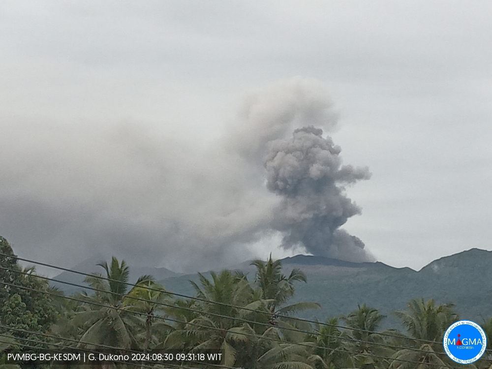
Indonesia , Dukono :
An eruption of Mount Dukono occurred on Friday, 30 August 2024 at 09:28 WIT with the height of the ash column observed at ± 900 m above the summit (± 1987 m above sea level). The ash column was observed to be white to grey in colour with a thick intensity, oriented towards the East. This eruption was recorded on a seismograph with a maximum amplitude of 20 mm and a duration of 71.77 seconds.
VOLCANO OBSERVATORY NOTICE FOR AVIATION – VONA
Issued : August 30 , 2024
Volcano : Dukono (268010)
Current Aviation Colour Code : ORANGE
Previous Aviation Colour Code : unassigned
Source : Dukono Volcano Observatory
Notice Number : 2024DUK002
Volcano Location : N 01 deg 41 min 35 sec E 127 deg 53 min 38 sec
Area : North Maluku, Indonesia
Summit Elevation : 3478 FT (1087 M)
Volcanic Activity Summary :
Eruption with volcanic ash cloud at 00h28 UTC (09h28 local).
Volcanic Cloud Height :
Best estimate of ash-cloud top is around 6358 FT (1987 M) above sea level or 2880 FT (900 M) above summit. May be higher than what can be observed clearly. Source of height data: ground observer.
Other Volcanic Cloud Information :
Ash cloud moving to east. Volcanic ash is observed to be white to gray. The intensity of volcanic ash is observed to be thick.
Remarks :
Eruption recorded on seismogram with maximum amplitude 20 mm and maximum duration 71.77 second. Tremor recorded on seismogram with maximum amplitude 2 mm.
Source et photo : Magma Indonésie.
Colombia , Galeras :
Pasto, August 27, 2024, 3:40 p.m.
From the monitoring of the activity of the Galeras volcano, the Colombian Geological Survey (SGC), an entity attached to the Ministry of Mines and Energy, reports that:
In the week of August 20 to 26, 2024, the activity of the volcano maintained a stable behavior. Compared to the previous week, the main variations in the monitored parameters were:
● An increase was recorded both in the frequency of earthquakes and in the energy released.
● The predominance of seismicity associated with the fracture of the rock material remained, within the volcanic system.
● Two sources of fracture earthquakes were identified; the first, located near the volcanic summit, at distances of less than 1 km and at depths of up to 2 km from the summit (4,200 m), with magnitudes of less than 1. The second source was located at distances of between 1.7 km and 6.8 km, towards the south-eastern sector of the volcano at depths of between 2 km and 6.2 km, from its summit; the maximum magnitude of these events was 1.5. Other few events were located scattered in the area of influence of the Galeras volcano, at distances of up to 14.2 km and at depths of up to 12.3 km. from its summit with a maximum magnitude of 1.8.

● Low gas emissions have been maintained, mainly from the fumarole fields of Las Chavas, to the West; El Paisita, to the North of the crater and from the main crater, with columns of white gas, of variable height and dispersion due to the action of the winds.
● The other volcanic monitoring parameters have shown stability.
Based on the above, the SGC recommends closely monitoring the evolution through the weekly bulletins and other information published through our official channels, as well as the instructions of the local and departmental authorities and the National Disaster Risk Management Unit (UNGRD).
Volcanic activity remains in yellow alert status: active volcano with changes in the behavior of the base level of the monitored parameters and other manifestations.
Source et photo : SGC
Guatemala , Fuego :
Atmospheric conditions: Clear
Wind: East
Precipitation: 35.2 mm.
Activity:
Degassing is observed above the crater, weak to moderate explosions are also recorded which occur at a rate of 6 to 11 per hour. These explosions generate columns of gas and ash with heights of 4400 to 4700 meters above sea level (14,436 to 15,420 feet) which move 12 to 15 km in a West and North-West direction. According to the WRF numerical model, the dispersion will remain towards the West and North-West during the day.
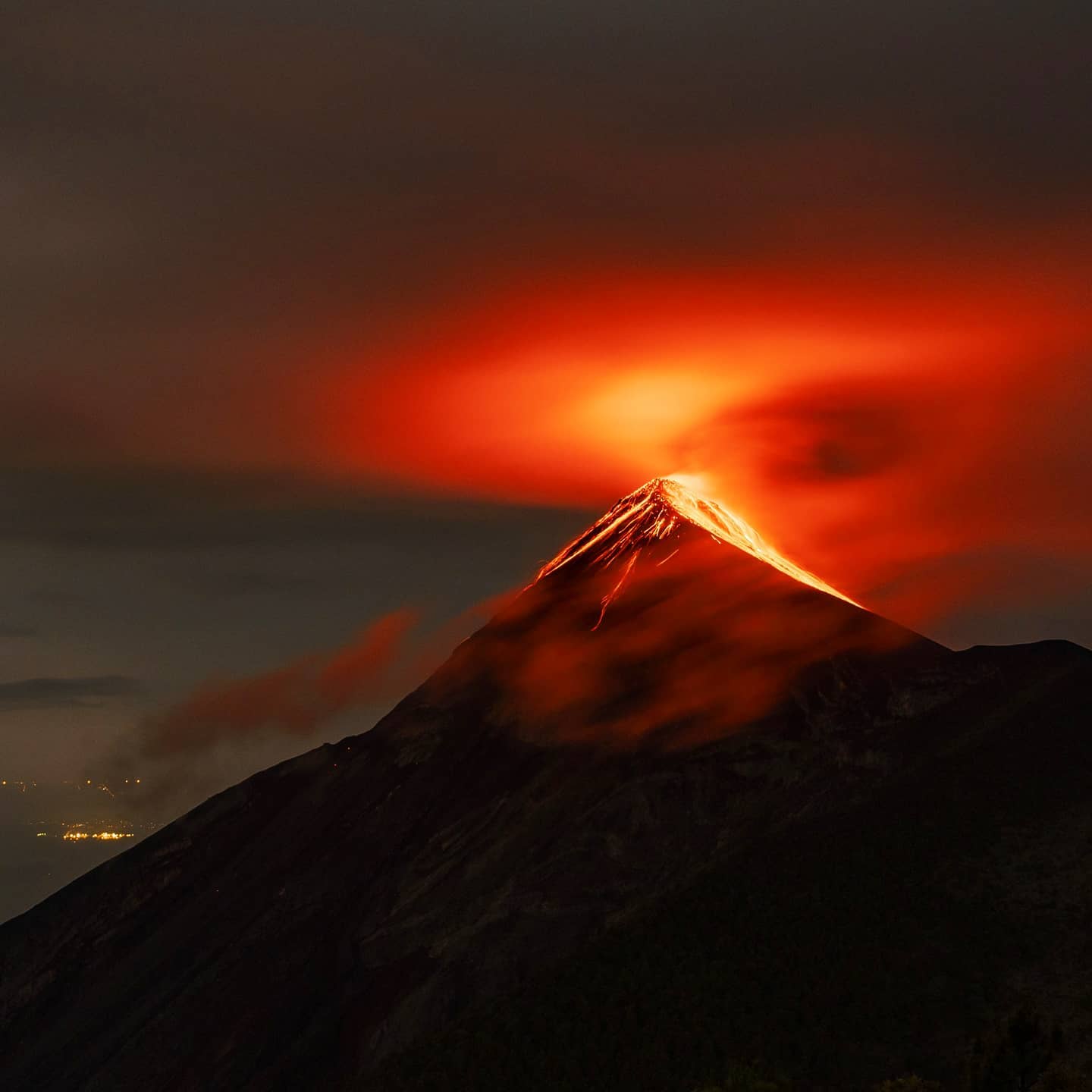
The explosions produce weak and moderate avalanches around the crater. Noises similar to those of airplane turbines lasting 1 to 2 minutes are also reported. At night and early in the morning, incandescence has been observed that reached heights of 200 to 300 meters above the crater. Falls of fine ash particles are reported in Yepocapa and other nearby towns. In the afternoon and at night, rains could cause lahars in different ravines of the volcano.
Source : Insivumeh
Photo : Diego Rizzo ( archive 2021)