July 09 , 2024.
Alaska , Aniakchak :
AVO/USGS Volcanic Activity Notice
Current Volcano Alert Level: NORMAL
Previous Volcano Alert Level: UNASSIGNED
Current Aviation Color Code: GREEN
Previous Aviation Color Code: UNASSIGNED
Issued: Monday, July 8, 2024, 12:52 PM AKDT
Source: Alaska Volcano Observatory
Notice Number: 2024/A516
Location: N 56 deg 54 min W 158 deg 12 min
Elevation: 4400 ft (1341 m)
Area: Alaska Peninsula
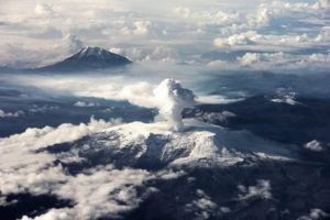
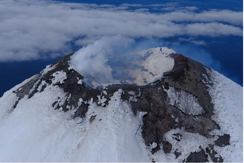
View of 1931 main crater, Aniakchak Caldera, looking from west to east across crater with Vent Mountain in the background.
Volcanic Activity Summary:
Field crews from the Alaska Volcano Observatory are performing seasonal maintenance on seismic monitoring equipment at Aniakchak Volcano. Enough local stations have been brought online to locate volcanic earthquakes and detect any potential activity above background at the volcano. As a result, the Aviation Color Code and Volcano Alert Level are being changed to GREEN/NORMAL.
Remarks:
Aniakchak volcano, located in the central portion of the Alaska Peninsula, consists of a stratovolcano edifice with a 6 mile (10 km) diameter summit caldera. The caldera-forming eruption occurred around 3,500 years ago. Post-caldera eruptions have produced lava domes, tuff cones, and larger spatter and scoria cone structures, including Half-Cone and Vent Mountain, all within the caldera. The most recent eruption occurred in 1931 and created a new vent and lava flows on the western caldera floor while spreading ash over much of southwestern Alaska. Aniakchak volcano is 16 miles (26 km) southeast of the nearest community, Port Heiden, and 416 miles (670 km) southwest of Anchorage, Alaska.
Source : AVO
Photo : Boyce, Ellie / Alaska Volcano Observatory / University of Alaska Fairbanks, Geophysical Institute
Alaska , Cleveland :
AVO/USGS Volcanic Activity Notice
Current Volcano Alert Level: NORMAL
Previous Volcano Alert Level: ADVISORY
Current Aviation Color Code: GREEN
Previous Aviation Color Code: YELLOW
Issued: Monday, July 8, 2024, 12:54 PM AKDT
Source: Alaska Volcano Observatory
Notice Number: 2024/A515
Location: N 52 deg 49 min W 169 deg 56 min
Elevation: 5676 ft (1730 m)
Area: Aleutians
Volcanic Activity Summary:
The Alaska Volcano Observatory is lowering the Aviation Color Code to GREEN and Volcano Alert Level to NORMAL at Mount Cleveland. Sulfur dioxide gas emissions continue to be detected on local gas monitoring sensors, however, gas emission rates are now typical to average values since local monitoring began 2 years ago. Steaming from the summit, slightly elevated surface temperatures in the summit crater, and occasional local earthquakes are still seen at Mount Cleveland, but this activity represents background behavior at this highly active Aleutian volcano.
The last eruptive activity at Mount Cleveland was a short-lived explosion during the evening (local time) of June 1, 2020. Despite the current pause, the eruptive period at Mount Cleveland, dating back to 2001, remains ongoing and future explosions are likely. These have occurred without warning and typically generate small clouds of volcanic ash that are a hazard in the immediate vicinity of the volcano, though more significant ash emissions are possible.
Mount Cleveland is currently monitored with a five-station real-time seismic network. Based on past events, explosive eruptions of Cleveland may occur with little or no warning. Rapid detection of an ash-producing eruption may be possible using a combination of seismic, infrasound, lightning, and satellite data.
Recent Observations:
[Volcanic cloud height] not applicable
[Other volcanic cloud information] Steam and sulfur dioxide gas emissions continue from Cleveland
Remarks:
Cleveland volcano forms the western portion of Chuginadak Island, a remote and uninhabited island in the east central Aleutians. The volcano is located about 45 miles (75 km) west of the community of Nikolski, and 940 miles (1500 km) southwest of Anchorage. The most recent significant period of eruption began in February 2001 and produced 3 explosive events that generated ash clouds as high as 39,000 ft (11.8 km) above sea level. The 2001 eruption also produced a lava flow and hot avalanche that reached the sea. Since then, Cleveland has been intermittently active producing small lava flows, often followed by explosions that generate small ash clouds generally below 20,000 ft (6 km) above sea level. These explosions also launch debris onto the slopes of the cone producing hot pyroclastic avalanches and lahars that sometimes reach the coastline.
Source : AVO
Photo : Bacon, Conor,
Indonesia , Lewotobi Laki-laki :
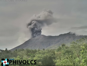
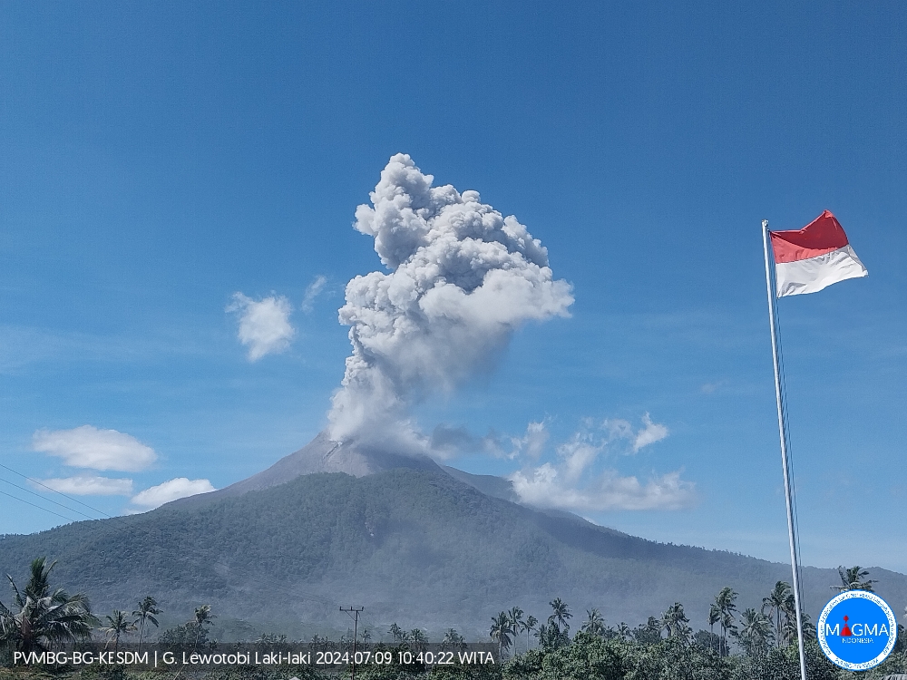
An eruption of Lewotobi Laki-laki occurred on Tuesday, July 9, 2024, at 10:35 a.m. WITA with the height of the ash column observed at ± 900 m above the summit (± 2484 m above sea level ). The ash column was observed to be gray with thick intensity, oriented towards the South-West and West. This eruption was recorded on a seismograph with a maximum amplitude of 37 mm and a duration of 289 seconds.
VOLCANO OBSERVATORY NOTICE FOR AVIATION – VONA
Issued : July 09 2024
Volcano : Lewotobi Laki-laki (264180)
Current Aviation Colour Code : ORANGE
Previous Aviation Colour Code : orange
Source : Lewotobi Laki-laki Volcano Observatory
Notice Number : 2024LWK193
Volcano Location : S 08 deg 32 min 20 sec E 122 deg 46 min 06 sec
Area : East Nusa Tenggara, Indonesia
Summit Elevation : 5069 FT (1584 M)
Volcanic Activity Summary :
Eruption with volcanic ash cloud at 02h35 UTC (10h35 local).
Volcanic Cloud Height :
Best estimate of ash-cloud top is around 7949 FT (2484 M) above sea level or 2880 FT (900 M) above summit. May be higher than what can be observed clearly. Source of height data: ground observer.
Other Volcanic Cloud Information :
Ash cloud moving from southwest to west. Volcanic ash is observed to be gray. The intensity of volcanic ash is observed to be thick.
Remarks :
Eruption recorded on seismogram with maximum amplitude 37 mm and maximum duration 289 second.
Source et photo : Magma Indonésie
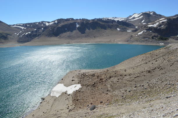
Chile , Laguna del Maule :
Seismology
The seismological activity of the period was characterized by the recording of:
338 seismic events of type VT, associated with the fracturing of rocks (Volcano-Tectonics). The most energetic earthquake had a Local Magnitude (ML) value equal to 1.9, located 7.7 km south-southwest of the center of the lagoon, at a depth of 5.6 km.
2 LP type seismic events, associated with fluid dynamics inside the volcanic system (Long Period). The size of the largest earthquake evaluated from the Reduced Displacement (RD) parameter was equal to 10.5 cm2.
Fluid Geochemistry
No anomalies have been reported in emissions of sulfur dioxide (SO2) into the atmosphere in the area near the volcanic complex, according to data published by the Tropopheric Monitoring Instrument (TROPOMI) and the Ozone Monitoring Instrument (OMI) Sulfur Dioxide Group.
Satellite thermal anomalies
During the period, no thermal alerts were recorded in the area associated with the volcanic complex, according to the analytical processing of Sentinel 2-L2A satellite images, in combination of false color bands.
Geodesy
The geodetic activity of the period was characterized by:
– Decrease in both horizontal and vertical deformation rates, compared to the previous period, reaching magnitudes slightly lower than the historical rates observed in the complex.
– Line lengths also show a slight decrease compared to the previous period, reaching lower values, but in the same order of magnitude and direction, as those recorded historically in this system.
Therefore, based on the geodetic data obtained during the period, a decrease in the rate of movement of stations is observed compared to the previous period, reaching values slightly lower than those observed historically in the complex. The maximum value of vertical deformation continues to be recorded at the station closest to the center of the lagoon.
Satellite geomorphological analysis
No morphological variation is identified on the Planet Scope and Sentinel 2 L2A images attributable to volcanic activity, when meteorological conditions allowed visualization of the system.
During the period assessed, the low-energy VT seismicity record remains, with specific periods where its levels of occurrence increase. Locations continue to be recorded mainly in active sources located to the South-West and South-East of the center of the lagoon. The volcanic deformation process remains active with rates similar to those observed historically.
The above indicates that the volcanic system is still recording activity with levels considered above its base threshold. In this way, the technical alert is maintained by:
YELLOW TECHNICAL ALERT: Changes in the behavior of volcanic activity
Source : Sernageomin
Photo : Claudio Arriagada.
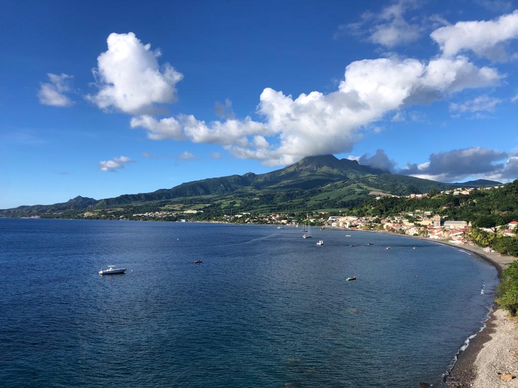
La Martinique , Montagne Pelée :
Weekly review. Paris Institute of Globe Physics / Martinique Volcanological and Seismological Observatory
Activity on Montagne Pelée, Saint-Pierre, July 5, 2024 at 3:00 p.m. local time (GMT-4)
An earthquake of volcanic origin was observed this week.
Between June 28, 2024 at 4:00 p.m. (UT) and July 5, 2024 at 4:00 p.m. (UT), the OVSM recorded 1 hybrid type earthquake, superficial and low energy, located under the southwest flank of the volcano. Hybrid signals contain low frequencies and are associated with the presence of fluids (gas, hydrothermal fluids) in the volcanic edifice.
This earthquake was not felt by the population.
The previous week, the OVSM had not recorded any earthquake of volcanic origin. As of July 5, 2024 and during the last 4 weeks, the OVSM has therefore observed a total of 10 volcanic earthquakes, or an average of 2 to 3 earthquakes per week.
During phases of volcanic reactivation of volcanoes similar to Montagne Pelée, it is usual to observe seismic activity varying in intensity and frequency.
For more details on observations and interpretations of volcanic activity over the longer term, refer to the OVSM monthly bulletins.
The alert level is currently YELLOW: vigilance.
Source :Direction de l’OVSM-IPGP
Photo : rci.fm