July 04 , 2024.
Italy , Stromboli :
Press release on Stromboli activity, July 3, 2024 7:18 p.m. (5:18 p.m. UTC).
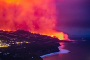
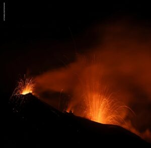
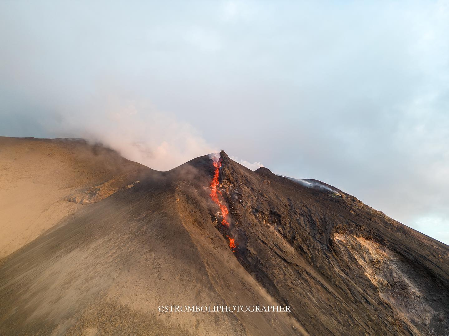
The National Institute of Geophysics and Volcanology, Osservatorio Etneo, communicated around 16:40 GMT from the network of surveillance cameras, a sudden intensification of projection activity was observed in the northern area of the crater which, at 16:46 GMT, produced a flow of incandescent material that spread rapidly along the Sciara del Fuoco, reaching the coastline and flowing into the sea.

From around 15:30 UTM, a progressive increase in the amplitude of the seismic signal was observed which went from a medium-high level to a high level. From around 16:20 UTM, a new and sudden increase in amplitude was observed which reached very high values and reached the most energetic value around 16:40 UTM. Currently, the amplitude of the seismic signal remains at very high levels.
Analysis of high-frequency GNSS network data does not reveal any variations in parameters outside of the normal variability of the signals.
Press release on Stromboli activity, July 3, 2024 8:03 p.m. (18:03 UTC).
The National Institute of Geophysics and Volcanology, Osservatorio Etneo, communicates that from around 17:00 GMT, thanks to images from the network of surveillance cameras, an overflow of lava can be observed in the area of the North crater, which is affected by an intense projection activity.

The lava overflow is currently located in the upper part of the Sciara del Fuoco and is rolling blocks down the slope. The amplitude of the seismic signal, after what was described in the previous press release, showed a tendency towards a rapid decrease and around 17:05 UTC it returned to high values, a level at which it currently maintains although it tends to decrease. The high-frequency GNSS network signal series shows no variation apart from normal fluctuations.
Further updates will be communicated shortly.
Source : INGV
Photos : Stromboli stati d’animo / Sebastiano Cannavo.
Vanuatu , Ambae :
On 27 June the Vanuatu Meteorology and Geohazards Department (VMGD) reported that steam-and-gas emissions from the active vents at Ambae were ongoing during the previous month based on webcam and satellite images and field observations. Seismic data also confirmed ongoing unrest. The emissions contained ash and sulfur dioxide during 29-30 June based on satellite data. According to the Wellington VAAC ash plumes rose km (8,000-11,000 ft) a.s.l. and drifted E, NE, W, and NW. Residents reported ashfall in areas downwind. The Alert Level remained at 2 (on a scale of 0-5), and the public was warned to stay outside of the Danger Zone, defined as a 2-km radius around the active vents in Lake Voui, and away from drainages during heavy rains
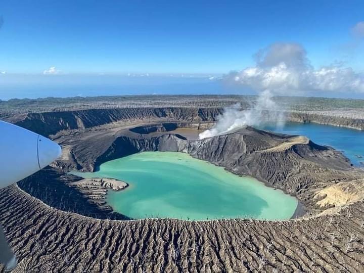
The island of Ambae, also known as Aoba, is a massive 2,500 km3 basaltic shield that is the most voluminous volcano of the New Hebrides archipelago. A pronounced NE-SW-trending rift zone with numerous scoria cones gives the 16 x 38 km island an elongated form. A broad pyroclastic cone containing three crater lakes (Manaro Ngoru, Voui, and Manaro Lakua) is located at the summit within the youngest of at least two nested calderas, the largest of which is 6 km in diameter. That large central edifice is also called Manaro Voui or Lombenben volcano. Post-caldera explosive eruptions formed the summit craters about 360 years ago. A tuff cone was constructed within Lake Voui (or Vui) about 60 years later. The latest known flank eruption, about 300 years ago, destroyed the population of the Nduindui area near the western coast.
Sources: Wellington Volcanic Ash Advisory Center (VAAC), Vanuatu Meteorology and Geohazards Department (VMGD) , GVP.
Photo : Air taxi Vanuatu (archive).
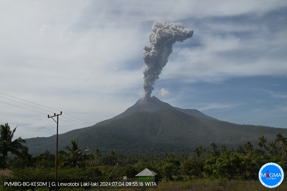
Indonesia , Lewotobi Laki-laki :
An eruption of Lewotobi Laki-Laki occurred on Thursday July 4, 2024 at 09:54 WITA with the height of the ash column observed at ± 900 m above the summit (± 2484 m above sea level) . The ash column was observed to be gray with thick intensity, oriented towards the South-West and West. This eruption was recorded on a seismograph with a maximum amplitude of 47.3 mm and a duration of 194 seconds.
VOLCANO OBSERVATORY NOTICE FOR AVIATION – VONA
Issued : July 04 , 2024
Volcano : Lewotobi Laki-laki (264180)
Current Aviation Colour Code : ORANGE
Previous Aviation Colour Code : orange
Source : Lewotobi Laki-laki Volcano Observatory
Notice Number : 2024LWK164
Volcano Location : S 08 deg 32 min 20 sec E 122 deg 46 min 06 sec
Area : East Nusa Tenggara, Indonesia
Summit Elevation : 5069 FT (1584 M)
Volcanic Activity Summary :
Eruption with volcanic ash cloud at 01h54 UTC (09h54 local).
Volcanic Cloud Height :
Best estimate of ash-cloud top is around 7949 FT (2484 M) above sea level or 2880 FT (900 M) above summit. May be higher than what can be observed clearly. Source of height data: ground observer.
Other Volcanic Cloud Information :
Ash cloud moving from southwest to west. Volcanic ash is observed to be gray. The intensity of volcanic ash is observed to be thick.
Remarks :
Eruption recorded on seismogram with maximum amplitude 47.3 mm and maximum duration 194 second.
PVMBG reported that eruptive activity at Lewotobi’s Laki-laki volcano continued during 26 June-2 July. Multiple daily gray or white-and-gray ash plumes that were sometimes dense rose 50-1,000 m above the summit and drifted SW, W, and NW. An eruptive event that began at 1421 on 29 June lasted 10 minutes and 14 seconds based on the seismic data and produced a dense ash plume that rose around 900 m above the summit and drifted SW and W. According to a news article the Frans Seda Maumere Airport (60 km WSW) canceled flights from Kupang to Maumere on 2 July, though cancellations may have also occurred during the previous two days. Ashfall continued to impact residents in areas to the S and SW . The Alert Level remained at 3 (the second highest level on a scale of 1-4) and the public was warned to stay outside of the exclusion zone, defined as a 3-km radius around both Laki-laki and Perempuan craters, 4 km to the NNW and SSE of Laki-laki.
Sources: Pusat Vulkanologi dan Mitigasi Bencana Geologi (PVMBG, also known as CVGHM), Antara News, Antara News , GVP.
Photo : PVMBG
Hawaii , Kilauea :
Wednesday, July 3, 2024, 1:55 PM HST (Wednesday, July 3, 2024, 23:55 UTC)
19°25’16 » N 155°17’13 » W,
Summit Elevation 4091 ft (1247 m)
Current Volcano Alert Level: ADVISORY
Current Aviation Color Code: YELLOW
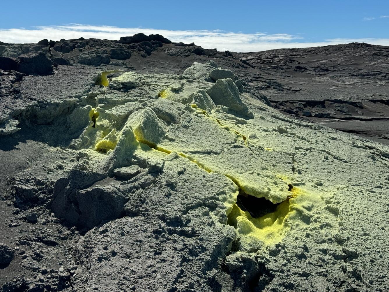
View of sulfur deposits in and around cracks near the June 3 eruption site on the Southwest Rift Zone of Kīlauea
SUMMARY
Kīlauea volcano is not erupting. Elevated rates of seismicity were observed beneath Kīlauea’s summit and upper East Rift Zone between June 27 and July 1, 2024. As of July 3, rates of seismicity have decreased to levels observed prior to June 27, but summit region unrest continues. Seismic unrest may continue to wax and wane with changes to the input of magma into the area. This unrest is consistent with increasing pressurization of the magmatic system underlying the Kīlauea summit region. Current conditions are not indicative of an imminent eruption, but this could change rapidly. Prior eruptions in the summit region have occurred with very little warning. Unrest has been restricted to the summit and upper rift zone regions; no unusual activity has been noted along Kīlauea’s middle and lower East Rift Zones. The USGS Hawaiian Volcano Observatory (HVO) continues to closely monitor Kīlauea for changes. The volcano alert level and aviation color code for Kīlauea remain at ADVISORY/YELLOW.
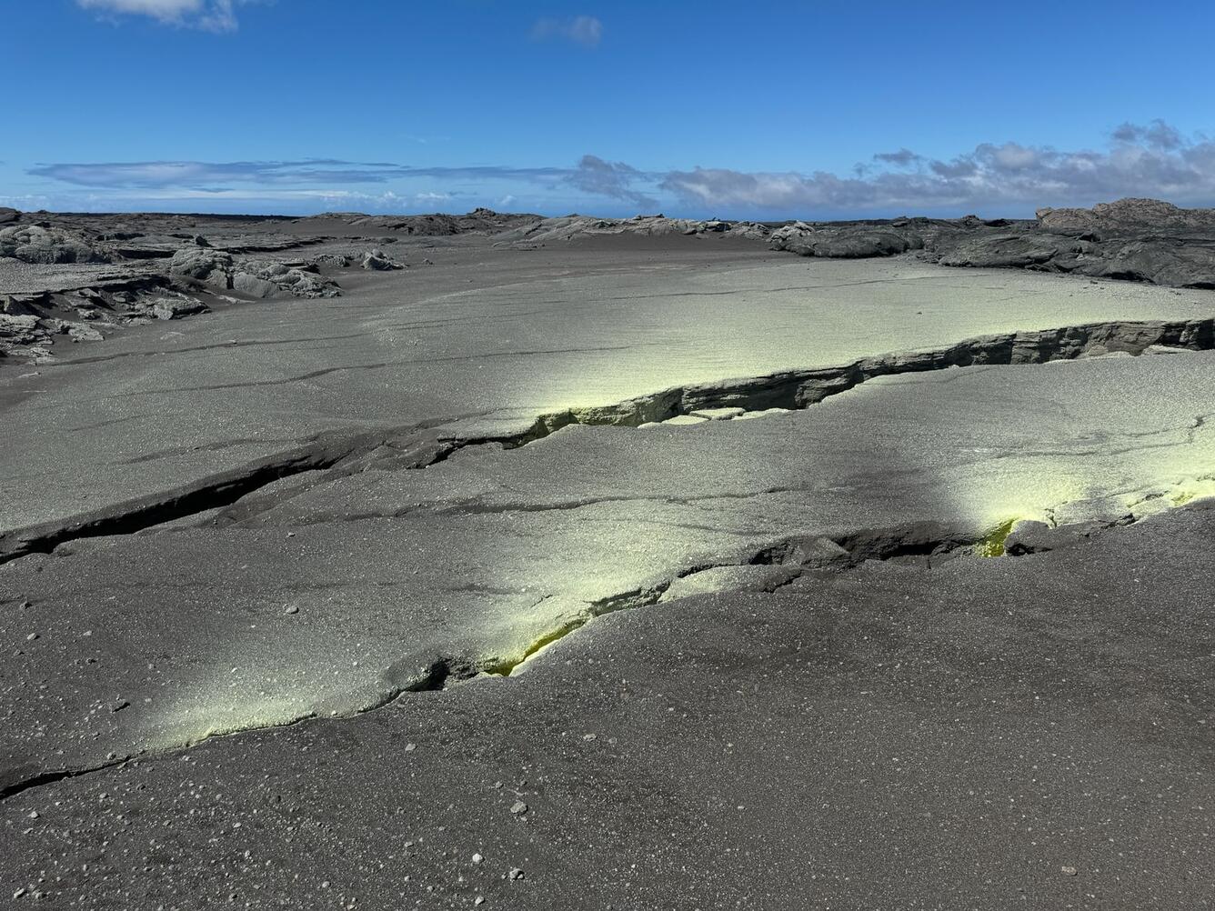
Sulfur deposits downwind of the cracks show the southwest direction of trade winds in Hawaii. These cracks were just uprift of the June 3 eruption site on Kīlauea.
RECENT OBSERVATIONS
Kīlauea last erupted on June 3, 2024. That eruption occurred approximately 3 km (2 miles) southwest of Kaluapele (Kīlauea caldera) within Hawai’i Volcanoes National Park. That eruption lasted less than 9 hours and generated small lava flows that covered about one third of a square mile (one half of a square kilometer). Since that eruption, patterns of seismicity and ground deformation indicate that magma has been re-accumulating in the storage regions beneath the summit.
Between June 27 and July 1, 2024, approximately 1,500 earthquakes were detected beneath the south part of Kaluapele and Kīlauea’s upper East Rift Zone (UERZ). Earthquake locations were concentrated between Keanakākoʻi and Pauahi craters, beneath Chain of Craters Road in Hawaiʻi Volcanoes National Park. Activity peaked during the late evening of Saturday, June 29, when more than 30 earthquakes were occurring per hour. Most events were smaller than magnitude-2, but there were several earthquakes large enough to be felt in Hawaiʻi Volcanoes National Park and in neighboring communities, including five earthquakes magnitude-3 or higher. The earthquakes occurred at depths of 1–4 km (0.6–2.5 mi) below the ground surface. This seismic unrest was not accompanied by any significant changes in ground deformation.
As of July 2, rates of seismicity have decreased to levels observed prior to June 27, but summit region unrest continues. Unrest may continue to wax and wane with changes to the input of magma into the area.
Source : HVO
Photos : USGS / M. Patrick.
Mexico , Popocatepetl :
July 3, 11:00 a.m. (July 3, 5:00 p.m. GMT)
Activity from the last 24 hours
15 exhalations were detected, accompanied by water vapor, volcanic gases and slight amounts of ash. In addition, 39 minutes of very low amplitude tremors were identified.
During the morning and until the time of this report, there is partial visibility towards the volcano crater due to cloudy conditions in the area, however, any broadcast will remain in a West-Northwest direction in due to wind direction.
The Popocatépetl volcanic warning fire is in yellow phase 2.
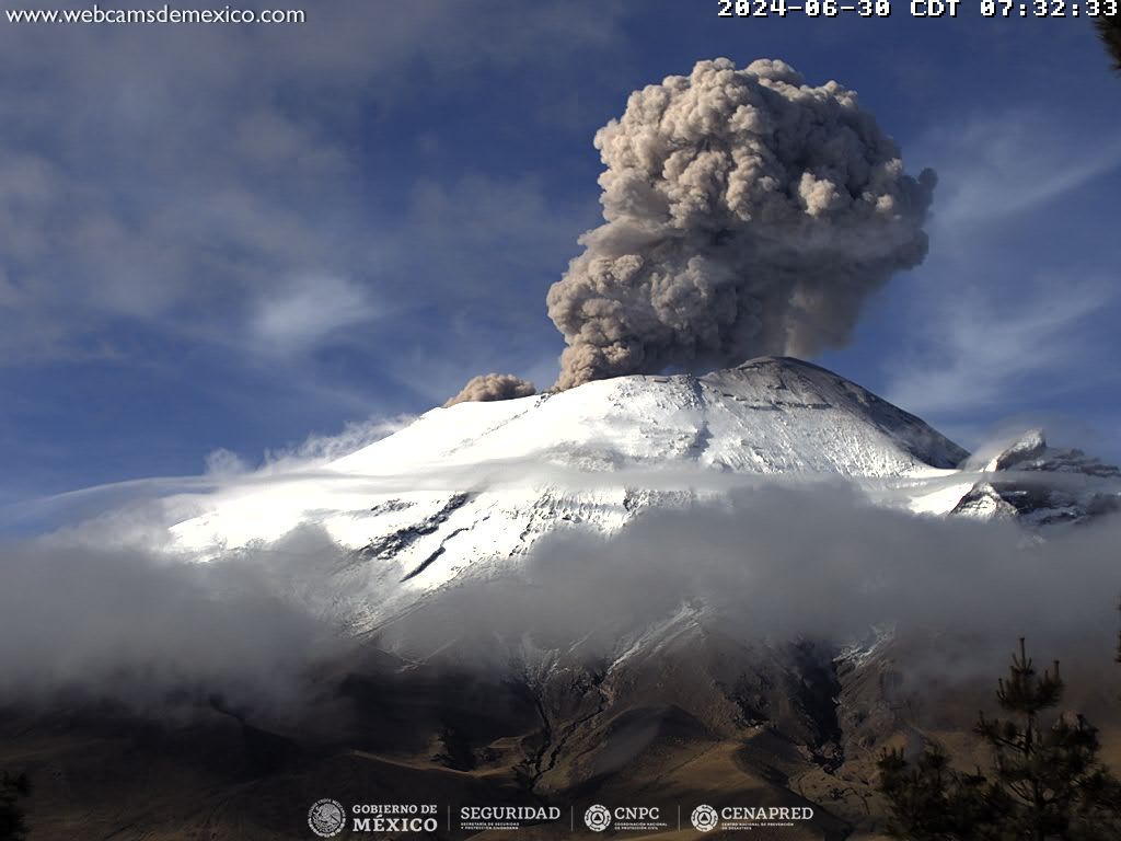
CENAPRED reported that eruptive activity continued at Popocatépetl during 25 June-2 July. The seismic network recorded 10-51 long-period events per day that were accompanied by steam-and-gas emissions; the emissions sometimes contained minor amounts of ash. Weather clouds sometimes prevented visual observations. The seismic network also recorded daily periods of tremor as short as 14 minutes to as long as five and a half hours. A M 1.5 volcano-tectonic earthquake was recorded during 28-29 June. According to the Washington VAAC ash plumes visible in webcam and satellite images rose to 5.8-6.4 km (19,000-21,000 ft) a.s.l. (or as high as 1 km above the crater rim) and drifted NW and SW during 29-30 June. The Alert Level remained at Yellow, Phase Two (the middle level on a three-color scale) and the public was warned to stay 12 km away from the crater.
Sources: Centro Nacional de Prevencion de Desastres (CENAPRED), Washington Volcanic Ash Advisory Center (VAAC) , GVP.