July 01 , 2024.
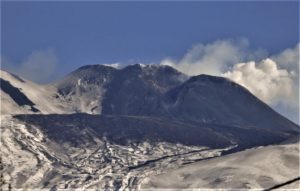
Hawaii , Kilauea :
Sunday, June 30, 2024, 8:24 AM HST (Sunday, June 30, 2024, 18:24 UTC)
19°25’16 » N 155°17’13 » W,
Summit Elevation 4091 ft (1247 m)
Current Volcano Alert Level: ADVISORY
Current Aviation Color Code: YELLOW
Activity Summary:
Kīlauea volcano is not erupting. A seismic swarm that began on June 27 beneath the upper East Rift Zone—just southeast of the summit region—escalated in intensity last night, though the earthquake rate has eased slightly this morning. There were no significant changes in ground deformation associated with this escalation of seismicity, but longer-term inflation of the summit and upper rift zones has persisted since the end of the June 3, 2024, eruption. Any substantial increases in seismicity and/or deformation could result in a new eruptive episode, but there are no signs of an imminent eruption at this time.
Summit and Upper Rift Zone Observations:
There were over 500 earthquakes detected beneath the upper East Rift Zone and surrounding areas over the past 24 hours, mostly at depths of 1.5–3 km (1–1.8 mi). Seismicity was already elevated as part of a swarm that began on June 27, then the earthquake rate further escalated late yesterday, reaching a peak of approximately 30 events per hour around midnight. The largest of these earthquakes were four M3.0 events that occurred near the intersection between Chain of Craters Road and Hilina Pali Road in Hawaiʻi Volcanoes National Park, at similar depths to the rest of the swarm. This morning, the earthquake rate has slowed to approximately 20 earthquakes per hour, which still represents heightened unrest compared to before the June 27 swarm.
There were no obvious changes in ground deformation associated with the escalation of seismicity, but slowing inflationary tilt over the past few days has transitioned to slight deflationary tilt: instruments at Uēkahuna northwest of the summit and at Sand Hill southwest of the summit respectively recorded approximately 7 microradians and 2 microradians of net deflation over the past 24 hours. GPS instruments around the summit region continue to show slow, longer-term inflation since the end of the June 3, 2024 eruption. The most recent measurement of the summit’s SO2 emission rate was approximately 75 tonnes per day on June 28.
Middle and Lower Rift Zone Observations:
Rates of seismicity and ground deformation beneath the middle and lower East Rift Zone and lower Southwest Rift Zone remain low. Recent eruptive activity and ongoing unrest have been restricted to the summit and upper rift zone regions. Measurements from continuous gas monitoring stations downwind of Puʻuʻōʻō in the middle East Rift Zone—the site of 1983–2018 eruptive activity—remain below detection limits for SO2, indicating that SO2 emissions from Puʻuʻōʻō are negligible.
Source :HVO
Photo : USGS/ M. Patrick.
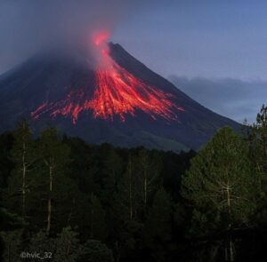
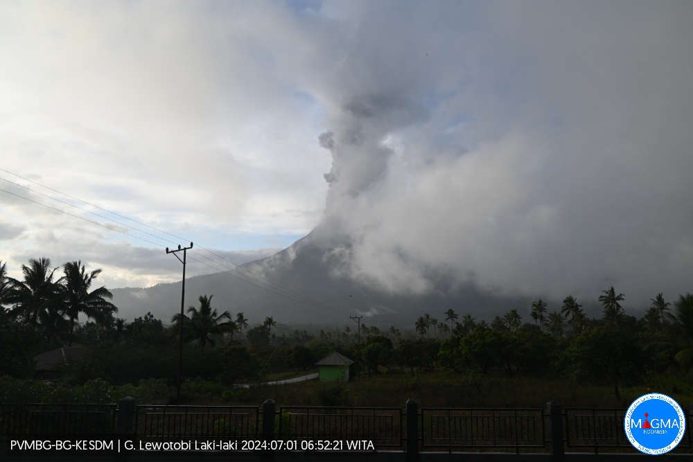
Indonesia , Lewotobi Laki-laki :
An eruption of Mount Lewotobi Laki-Laki occurred on Monday July 1, 2024 at 06:45 WITA with an ash column height observed at ±700 m above the summit (±2284 m above sea level) . The ash column was observed to be gray with thick intensity, oriented towards the South-West and West. This eruption was recorded on a seismograph with a maximum amplitude of 16.2 mm and a duration of 754 seconds.
VOLCANO OBSERVATORY NOTICE FOR AVIATION – VONA
Issued : June 30 , 2024
Volcano : Lewotobi Laki-laki (264180)
Current Aviation Colour Code : ORANGE
Previous Aviation Colour Code : orange
Source : Lewotobi Laki-laki Volcano Observatory
Notice Number : 2024LWK148
Volcano Location : S 08 deg 32 min 20 sec E 122 deg 46 min 06 sec
Area : East Nusa Tenggara, Indonesia
Summit Elevation : 5069 FT (1584 M)
Volcanic Activity Summary :
Eruption with volcanic ash cloud at 22h45 UTC (06h45 local).
Volcanic Cloud Height :
Best estimate of ash-cloud top is around 7309 FT (2284 M) above sea level or 2240 FT (700 M) above summit. May be higher than what can be observed clearly. Source of height data: ground observer.
Other Volcanic Cloud Information :
Ash cloud moving from southwest to west. Volcanic ash is observed to be gray. The intensity of volcanic ash is observed to be thick.
Remarks :
Eruption recorded on seismogram with maximum amplitude 16.2 mm and maximum duration 754 second.
Source et photo : Magma Indonésie .
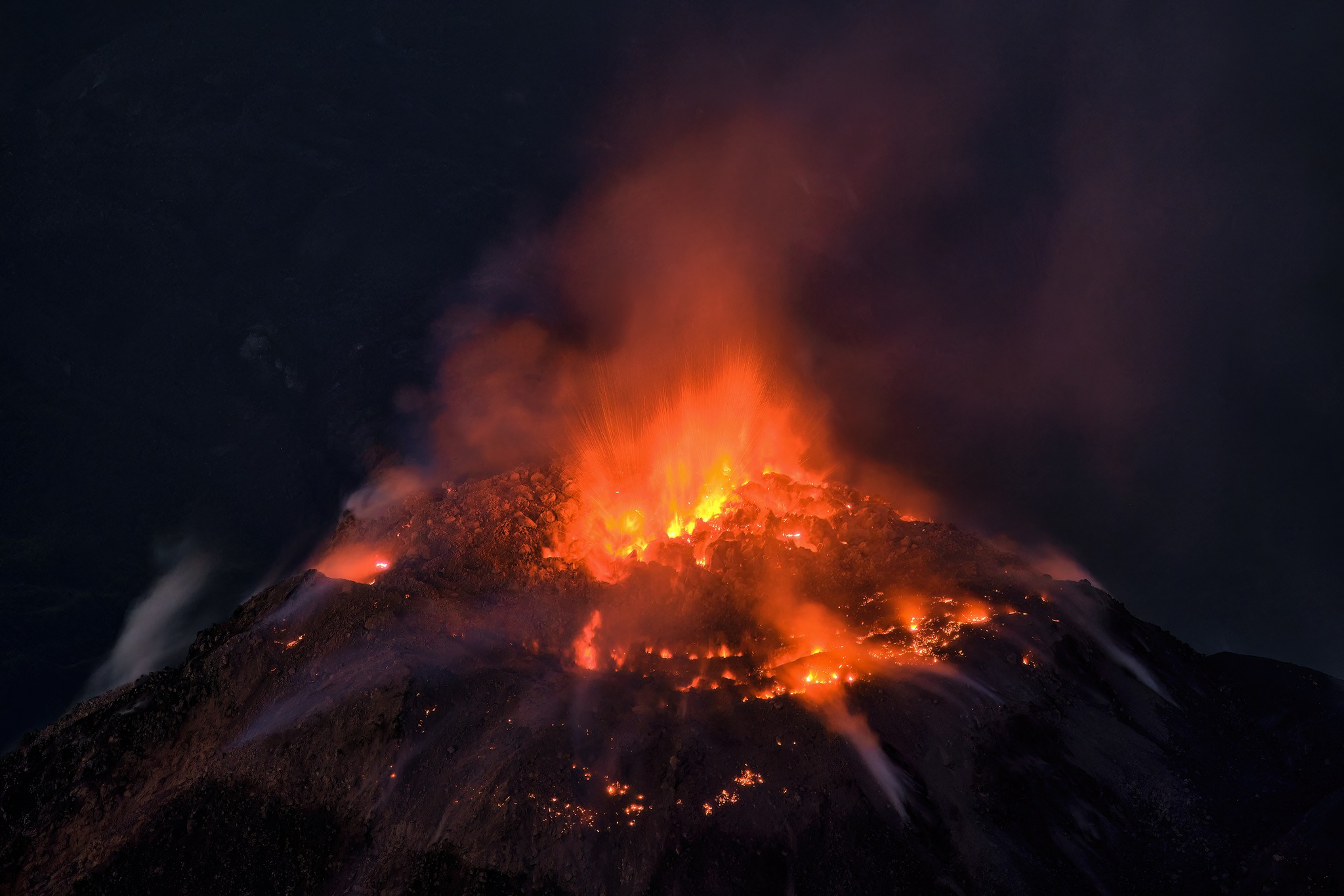
Ecuador , Sangay :
DAILY REPORT ON THE STATE OF THE SANGAY VOLCANO, Sunday June 30, 2024.
Information Geophysical Institute – EPN.
Surface activity level: High, Surface trend: No change
Internal activity level: High, Internal trend: No change
Seismicity: From June 29, 2024, 11:00 a.m. to June 30, 2024, 11:00 a.m.:
Seismicity:
Below is the count of seismic events recorded at the reference station
Explosion (EXP) 180
Precipitation/Lahars:
Rain was recorded in the volcano area without generating mud or debris flows. **In the event of heavy rains, these could remobilize the accumulated materials, generating mud and debris flows which would descend the sides of the volcano and flow into adjacent rivers.
Emissions/ash column:
During the last 24 hours, thanks to the system of surveillance cameras, several emissions of gas and ash were recorded, the columns of which reached heights between 700 and 1,500 meters above the level of the crater in the directions North-Northwest, North-West and South-West. In connection with this activity, the VAAC agency in Washington generated a report for an emission from a height of 1,500 meters above the level of the crater, in a southwest direction.
Observation:
Since yesterday afternoon and until the submission of this report, the volcano has remained mostly cloudy.
Alert level: yellow
Source : IGEPN
Photo : Camara Rota
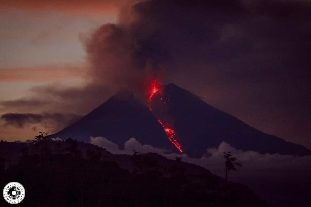
Guatemala , Santiaguito :
Weather conditions: Clear weather.
Wind: South-East.
Precipitation: 13.0 mm.
Activity:
The Santa María-Santiaguito Volcanic Complex Observatory reports volcanic activity on Dome Caliente. During the night and early morning, incandescence was constantly observed on the dome and the sides of the dome, a product of the constant extrusion of blocky lava. This extrusion again feeds the upper part of the lava flow which extends along the southwest flank. Small to moderate explosions were observed that raised ash columns to heights of up to 700 meters above the dome, producing short-distance pyroclastic flows toward the west, southwest, and south flanks of the Caliente dome. , piling the materials on promontories on the sides of the Dome.
These explosions occur at a rate of 1 to 3 per hour and are accompanied by faint outgassing noises similar to those of an airplane turbine. Degassing is constant, with weak columns of water vapor and other magmatic gases at heights of up to 300 meters above the dome’s dome, which the wind moves northwestward. Due to the rains, steam rises from the front of the lava flow located in the Zanjón Seco and San Isidro ravines. Afternoon and evening rain could cause lahars to descend into the channels that descend from the Caliente Dome. The activity remains at a high level, so it is possible that with the explosions or under the effect of gravity, part of the accumulated materials collapse and that pyroclastic flows over long distances are generated towards the South. West, South and South-East.
Source : Insivumeh.
Photo : Thomas Spinner via FB .
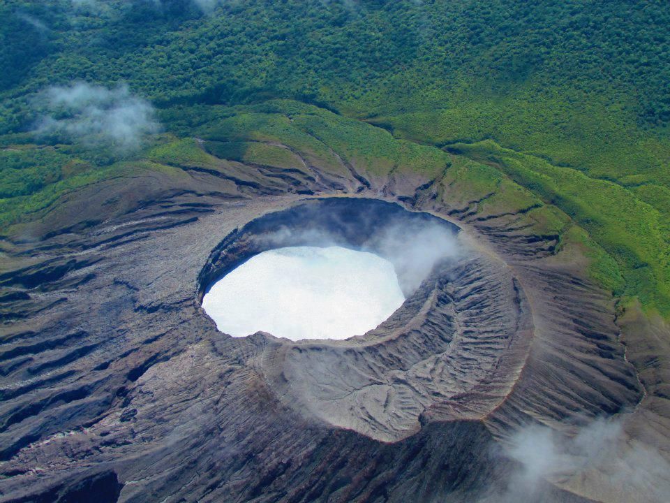
Costa Rica , Rincon de la Vieja / Poas :
Weekly volcanic monitoring bulletin OVSICORI-UNA.
Rincón de la Vieja Volcano
Latitude: 10.83°N;
Longitude: 85.34°W;
Altitude: 1916 m
Current activity level: Caution
Possible manifestations: Eruptions or explosions, ash emissions, pyroclastic flows, lahars, substantial increase in the amplitude of seismic events, intensification of degassing.
This week, 6 small phreatic eruptions were recorded. None of them generated lahars or ash emissions. The background tremor is observed to vary in energy and frequency range, generally between 1.5 and 10 Hz. In some cases, this tremor appears segmented and with significant amplitude variations. Banded tremors were also observed on June 18 and 20, with abrupt interruptions of tremors between these events. In lesser presence, we observe a harmonic tremor accompanied by an acoustic tremor. The sporadic appearance of long period (LP) and tornillo type signals is observed.
Distal and proximal volcano-tectonic earthquakes associated with the rupture of rocks south of the volcano are also recorded. The greatest number of volcano-tectonic events occurred on June 16.
Constant degassing is observed from the crater when weather permits. In recent weeks, the extension of the base of the volcano is not significant. After the rapid subsidence, synchronous with the fall in RSEM (seismic energy) at the end of May, we observe stability of the summit. This week, low concentrations of SO2 are observed at the MultiGAS station. The Sentinel-5P satellite sensor detected SO2 in the atmosphere emitted by the Rincón on June 18, 2024. Observations of the crater on June 19 by ICE officials allowed them to note a slight increase in the lake level since June 4.
Poas Volcano
Latitude: 10.20°N;
Longitude: 84.23°W;
Altitude: 2687 m
Current Activity Level: Warning
Possible manifestations: Small eruptions, bubbling or geysers, significant gas emissions, temperature rise (incandescence), seismic swarms or volcanic tremor,
slight inflation-extension of the volcanic edifice.
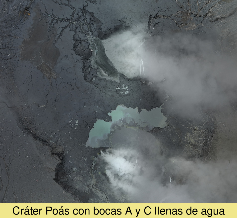
This week, seismic and acoustic activity has been very stable compared to previous weeks and is characterized by continuous tremors of moderate amplitude and LP type earthquakes. The pace of LP events increased to over 100 per day this week. No acoustic signal of bubbling has been detected since Tuesday May 28. Yesterday afternoon, an episode of harmonic tremor with an intensity greater than the background tremor was observed. In recent days, a contraction of the crater with a subsidence of the north of the crater continues to be observed. The gas compositions highlight changes linked to the decrease in activity and the entry of water. The SO2/CO2 ratio remains relatively stable, averaging 1.4 ± 0.6 this week. The H2S/SO2 ratio remains stable with values close to 0.5. The SO2 concentration recorded by the ExpoGAS station at the lookout reached a maximum of 2.8 ppm this week and in general little gas is observed reaching the lookout. The Sentinel satellite detected the SO2 plume in the atmosphere on June 18. The water level in mouth A has increased by around 0.2 m this week, the level in mouth C is rising faster but is still several meters below this level.
Source : Ovsicori
Photos : Raul Mora / RSN / UCR , Ovsicori ,