May 08 , 2024.
Italy , Stromboli :
WEEKLY BULLETIN, from April 29, 2024 to May 5, 2024. (issue date May 7, 2024)
SUMMARY STATEMENT OF ACTIVITY
In light of the monitoring data, it appears:
1) VOLCANOLOGICAL OBSERVATIONS: During this period, normal Strombolian activity with projection activity was observed. The total hourly frequency fluctuated between medium values (14 events/h) and high values (19 events/h). The intensity of the explosions was mainly low and medium in the North and South-Central crater areas.
2) SISMOLOGY: The monitored seismological parameters do not show significant variations. 2 earthquakes with a local magnitude greater than 1.0 were recorded.
3) GROUND DEFORMATIONS: The ground deformation monitoring networks did not show significant variations.
4) GEOCHEMISTRY: SO2 flux at medium level
The CO2 flux in the summit zone is at average values.
The C/S ratio in the plume is high.
The helium isotopic ratio in the thermal aquifer is at high values.
CO2 flow in Mofeta in the San Bartolo area: medium-low values.
CO2 flux in Scari: stable values at average levels.
5) SATELLITE OBSERVATIONS: Thermal activity observed by satellite was generally weak.

VOLCANOLOGICAL OBSERVATIONS
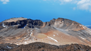
During the observed period, the eruptive activity of Stromboli was characterized through the analysis of images recorded by the INGV-OE surveillance cameras located at Pizzo (SPT), at 190 m altitude (SCT-SCV) and at Point dei Corvi. (SPCT). The explosive activity was mainly produced by 3 (three) eruptive vents located in the North zone of the crater and by 3 (three) vents located in the South Central zone. Due to unfavorable weather conditions, the visibility of the crater terrace on May 3-4, 2024 was insufficient for a correct description of the eruptive activity.
Observations of explosive activity captured by surveillance cameras
In the North crater area (N), with two vents located in sector N1, explosive activity was observed which was mostly low (less than 80 m high) to medium (less than 150 m high) and sometimes high (greater than 150 m). In the N2 sector, activity was rather weak. Furthermore, almost continuous and sometimes intense projection activity was observed in sector N1 and discontinuous and of low intensity in sector N2. The products emitted in the eruption were mainly coarse materials (bombs and lapilli). The average frequency of explosions fluctuated between 8 and 14 events/h.
In the South-Central (CS) zone, sector C did not show significant activity while in sector S1, modest jets of pressurized gas were only occasionally observed. In sector S2, with two emission points, the explosions were of low intensity (less than 80 m height) and medium intensity (less than 150 m height) emitting coarse materials mixed with fines. The average frequency of explosions varied from 5 to 7 events/h.
Source : INGV
Photo : Stromboli stati d’animo / Sebastiano Cannavo.
Italy / Sicily , Etna :
WEEKLY BULLETIN, from April 29, 2024 to May 5, 2024. (issue date May 7, 2024)
SUMMARY STATEMENT OF ACTIVITY
In light of the monitoring data, it appears:
1) VOLCANOLOGICAL OBSERVATIONS: Degassing activity mainly in the Bocca Nuova crater (BN) and secondarily in the Southeast crater (CSE), with occasional transients in the regime, characteristics and methods of gas emission .
2) SEISMOLOGY: Low seismic activity due to fracturing. Decrease in the average amplitude of the volcanic tremor from medium to low (from April 21).
3) INFRASOUND: Moderate infrasound activity with sources located near the Southeast crater.
4) GROUND DEFORMATIONS: During the last month of observation, the ground deformation monitoring networks did not record any significant changes.
5) GEOCHEMISTRY: SO2 flux at an average and increasing level
The CO2 flow is stable, at average values
There is no update of the partial pressure of dissolved CO2.
The helium isotopic ratio is high.
6) SATELLITE OBSERVATIONS: Thermal activity observed by satellite was generally low level with some rare and isolated thermal anomalies of moderate level.
VOLCANOLOGICAL OBSERVATIONS
During the observation period, the monitoring of the volcanic activity of Etna was carried out through the analysis of images from the network of surveillance cameras of the National Institute of Geophysics and Volcanology, Observatory of Etna (INGV-OE) and through a series of field inspections and drone overflights carried out by INGV staff.
During the period, the activity of the summit craters showed no variation compared to the previous period and, more generally, compared to what has been observed since the beginning of 2024 and was characterized by degassing activity mainly fed by the Bocca Nuova crater (BN) and the Southeast crater (CSE).
Compared to the previous period, however, transients were observed in the gas regime, characteristics and emission methods.

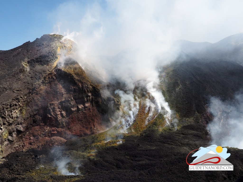
Images of the activity on April 7 at Bocca Nuova, taken (b) at 1:14 p.m. by the Bronte visible camera (EBVH) and by INGV staff on the ground (a, c). Image of craters BN1 and BN2 taken (d) during an inspection by INGV staff on April 14, which highlights the change in morphology of BN2.
In particular, the Bocca Nuova (BN) crater showed ordinary outgassing activity mainly affecting the two craters BN1 and BN2, with a typically impulsive regime and gas emission, at high temperatures that sometimes cause visible lightning at night and the formation of BN2 smoke rings.
On April 7 at 1:10 p.m. GMT, a strong emission of ash lasting about 4 minutes was observed: the cloud reached an altitude of about 5 km above sea level and quickly dispersed to the south. In the following days (April 8, 11 and 22), further isolated and light emissions of ash occurred.
During an inspection carried out on April 14, it was possible to observe a morphological change in the crater of pit BN2, probably associated with the activity that occurred on April 7 and subsequent collapse phenomena.
Finally, the Voragine crater (VOR) currently remains obstructed and in a state of inactivity, while the North-East crater (CNE) highlights weak degassing fueled by small areas of fumaroles inside and on the edge of the crater highlighted by drone observations on April 9. and during an inspection of the summit area by INGV staff on April 14.
Source : INGV
Photos : Guides Etna Nord – Etna Guide Company , INGV.
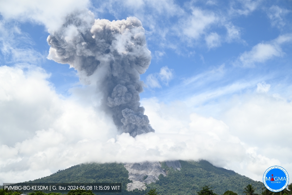
Indonesia , Ibu :
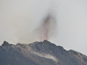
Mount Ibu exhibited an eruption on Wednesday, May 8, 2024 at 01:58 WIT with the height of the ash column observed at ±2000 m above the summit (±3325 m above sea level). The ash column was observed to be gray to black in color with thick intensity, oriented towards the East and South-East. This eruption was recorded on a seismograph with a maximum amplitude of 28 mm and a duration of 127 seconds.
VOLCANO OBSERVATORY NOTICE FOR AVIATION – VONA
Issued : May 07 , 2024
Volcano : Ibu (268030)
Current Aviation Colour Code : ORANGE
Previous Aviation Colour Code : orange
Source : Ibu Volcano Observatory
Notice Number : 2024IBU002
Volcano Location : N 01 deg 29 min 17 sec E 127 deg 37 min 48 sec
Area : North Maluku, Indonesia
Summit Elevation : 4240 FT (1325 M)
Volcanic Activity Summary :
Eruption with volcanic ash cloud at 16h58 UTC (01h58 local).
Volcanic Cloud Height :
Best estimate of ash-cloud top is around 10640 FT (3325 M) above sea level or 6400 FT (2000 M) above summit. May be higher than what can be observed clearly. Source of height data: ground observer.
Other Volcanic Cloud Information :
Ash cloud moving from east to southeast. Volcanic ash is observed to be gray to dark. The intensity of volcanic ash is observed to be thick.
Remarks :
Eruption recorded on seismogram with maximum amplitude 28 mm and maximum duration 127 second.
Source et photo : Magma Indonésie
Iceland , Reykjanes Péninsula :
Ongoing magma accumulation and land rise in Svartsengi . Limited activity in the crater
Updated 7. May at 17:45 UTC
Land rise continues in Svartsengi
The rate of magma accumulation remains similar to that observed in recent weeks
Visible activity in the active crater has decreased in recent days
There is a growing likelihood that the current eruption may increase in intensity or that a new eruptive fissure may open
Warning of increased volcanic activity or a new eruption could be very brief
The hazard assessment remains unchanged
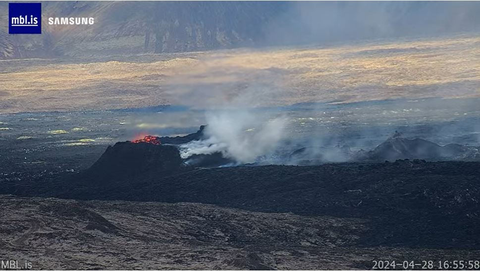
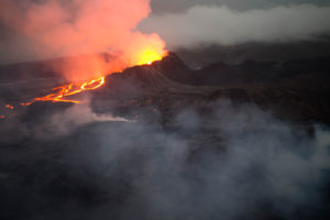
The eruption at the Sundhnúk crater row continues. Lava continues to flow a short distance from the active vent, but activity within this crater is decreasing. Over the past week, little to no change has been observed in the southern part of the lava field near the defensive barriers east of Grindavík.
Magma accumulation and land rise continue in Svartsengi. The rate has remained consistent in recent weeks . These measurements indicate that pressure continues to rise in the magma chamber. Therefore, a new dike intrusion from the magma chamber beneath Svartsengi towards the Sundhnúk crater row remains possible.
Seismic activity has increased steadily in and around the eruption area over the past week. Most of the earthquakes, which are generally smaller than magnitude 1, are located north of the current eruption site, between Sundhnúk and Stóra Skógfell, south of Þorbjarnar in the large valley near Grindavík, and between Grindavík and the current eruption site. This gradual increase in seismic activity is likely a sign that stress is being released around the eruption site on the Sundhnúk crater row due to increased pressure in the magma chamber beneath Svartsengi.
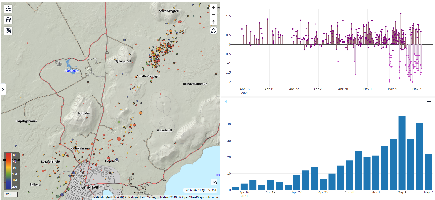
This figure shows a map with the locations of earthquakes since April 15th (left), along with automatic magnitudes (top right) and the number of earthquakes per day (bottom right).
It is difficult to predict when there might be an end to the ongoing sequence of unrest that began in late October
As previously stated, there is still uncertainty about the progression of this episode now that the volcanic eruption has been ongoing for over a month, while magma continues to accumulate in the magma chamber beneath Svartsengi. Although the scenarios outlined above are considered to be most likely, close monitoring is ongoing to determine if magma is seeking paths other than towards the Sundhnúk crater row. Areas north of Stóra-Skógfell and south of Hagafell and Þorbjarnar are being closely monitored.
If magma moves towards the surface outside of the areas where recent eruptions have already occurred, the warning signals are expected to be more significant, manifesting with stronger and more intense seismicity than observed in the lead-up to the most recent eruptions.
Source : IMO
Photo : mbl.is ( archive) , IMO.
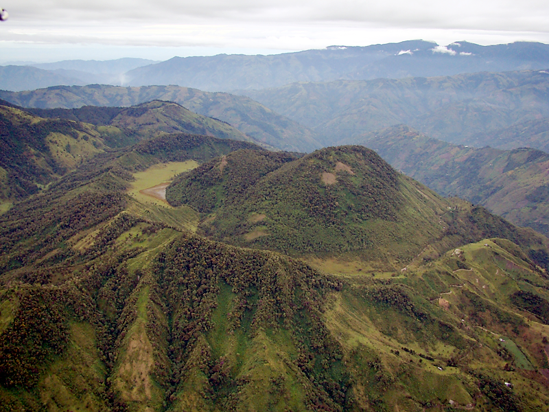
Colombia , Cerro Machin :
Manizales, May 7, 2024, 7:50 p.m.
Weekly Activity Bulletin: Cerro Machín Volcano
Regarding the monitoring of the activity of the CERRO MACHÍN VOLCANO, the COLOMBIAN GEOLOGICAL SERVICE (SGC), an entity attached to the MINISTRY OF MINES AND ENERGY, reports that:
For the week of April 30 to May 6, 2024, the recording of seismicity associated with the fracturing of rocks inside the volcanic edifice continued. Compared to the previous week, this seismic activity increased in number of earthquakes recorded and seismic energy released. The earthquakes were located mainly on the west-southwest and south-west flanks of the volcanic edifice, at distances less than 2 km from the main dome. The depths of the earthquakes varied between 2 and 5 km. On May 3 and 4, the majority of the week’s earthquakes were recorded.
The maximum magnitude recorded was 1.6, corresponding to the earthquake that occurred on May 4 at 8:11 a.m., located approximately 1 km west-southwest of the main dome, at a depth of approximately 3 km.
The other parameters measured and used for the diagnosis of volcanic activity did not present significant changes during the period evaluated.
The alert status for volcanic activity remains at: YELLOW ALERT: ACTIVE VOLCANO WITH CHANGES IN THE BEHAVIOR OF THE BASE LEVEL OF MONITORED PARAMETERS AND OTHER MANIFESTATIONS.
Source et photo : SGC
Philippines , Taal :
TAAL VOLCANO ADVISORY , 08 May 2024 , 09:00 AM
This is a notice of weak phreatic activity at Taal Volcano.
Weak phreatic or steam-driven eruption at the Taal Main Crater occurred this morning between 8:27 AM to 08:31 AM based on visual, seismic and infrasound records of the Taal Volcano Network (TVN). The event produced white steam-laden plumes that rose 2000 meters above the Main Crater before drifting southwest based on IP camera monitors. Sulfur dioxide (SO2) emissions have decreased last week and averaged 2,191 tonnes/day on 06 May 2024. Nonetheless, average SO2 emissions since January this year remain high at 8,913 tonnes/day. Weak phreatic activity is likely driven by the continued emission of hot volcanic gases at the Taal Main Crater and could be succeeded by similar events. The background levels of volcanic earthquake activity and ground deformation detected at Taal indicate that unrest is unlikely to progress into magmatic eruption.
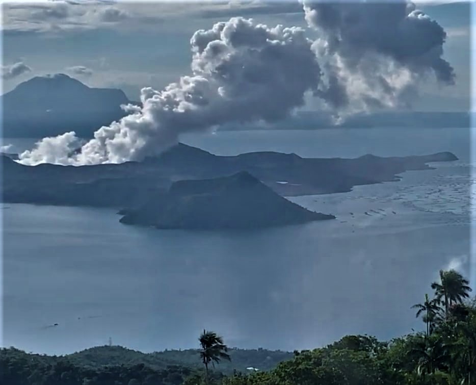
DOST-PHIVOLCS reminds the public that Alert Level 1 prevails over Taal Volcano, which means that it is still in abnormal condition and should not be interpreted to have ceased unrest nor ceased the threat of eruptive activity. At Alert Level 1, sudden steam-driven or phreatic explosions, volcanic earthquakes, minor ashfall and lethal accumulations or expulsions of volcanic gas can occur and threaten areas within TVI. Furthermore, degassing of high concentrations of volcanic SO2 continues to pose the threat of potential long-term health impacts to communities around Taal Caldera that are frequently exposed to volcanic gas. DOST-PHIVOLCS strongly recommends that entry into TVI, Taal’s Permanent Danger Zone or PDZ, especially the vicinities of the Main Crater and the Daang Kastila fissure, must remain strictly prohibited. Local government units are advised to continuously monitor and assess preparedness of their communities and undertake appropriate response measures to mitigate hazards that could be posed by long-term degassing and related phreatic activity. Civil aviation authorities must advise pilots to avoid flying close to the volcano as airborne ash and ballistic fragments from sudden explosions and wind-remobilized ash may pose hazards to aircrafts.
DOST-PHIVOLCS is closely monitoring Taal Volcano’s activity and any new significant development will be immediately communicated to all stakeholders.
Source : Phivolcs
Photo : Kyle Aranza ( archive).