March 21 , 2024.
Iceland , Reykjanes Peninsula :
Eruptive activity stable on fifth day . Updated Hazard Assessment
Updated 20. March at 13:45 UTC
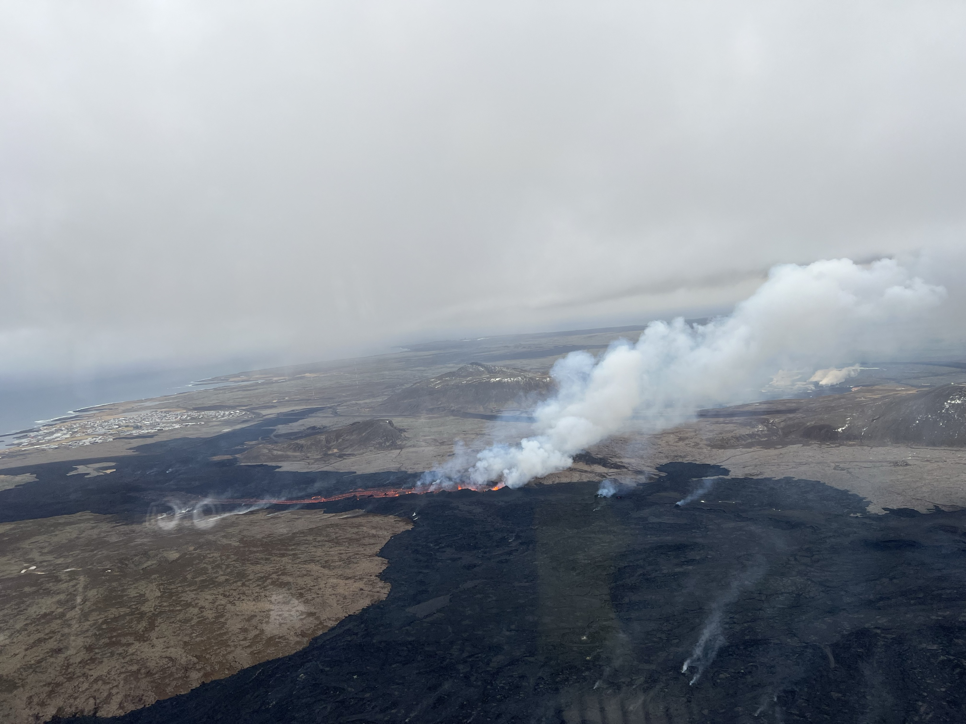
The eruptive activity appears to be relatively stable and eruptive vents remain in the same locations as yesterday. Lava flows from the craters towards the south, on top of lava which flowed in the first days of the eruption. Little or no movement has been detected on the lava flow fronts near the South Coast Road and Svartsengi. Seismic activity since the eruption began on Saturday night has been minor.
The weather forecast is increasing south-easterly winds today, 13-20 m/s in the afternoon, but subsides in the evenings. Gas pollution is thus dispersed to the north-west and could be detected in Reykjanesbær and nearby areas. Gas distribution forecast can be found here. On 17 March, SO2 gas emission from the eruption was measured up to 50 kg/s, but preliminary results from new measurements indicate that the emission of gas has decreased considerably since then.
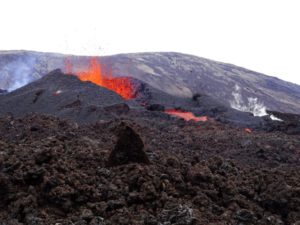
Overview of the eruption site taken during a flight this morning. It shows all active volcanic vents and the resulting flava flows southward. In the background, on the left, Grindavík and on the right, Svartsengi.
An InSAR image published yesterday showed clear signs of land inflation in Svartsengi from 17 to 18 March. GPS data from 18 March suggest that the inflation rate is possibly decreasing. This could be due to magma now flowing towards the surface in the Sundhnúkur crater row and therefore does not accumulate beneath Svartsengi. The development of the eruption and deformation signals over the next few days will reveal whether an equilibrium will be reached between the magma inflow beneath Svartsengi and the lava flow on the surface in the Sundhnúkur crater row.
This morning, experts from the National Land Survey of Iceland and the Institute of Natural History conducted aerial photography flights over the eruption site. From these images it is possible to estimate the size of the lava field and the average lava flow from the eruption. There estimates will be published as soon as the data have been processed.
Source : IMO
Photo : Birgir V. Óskarsson – Institut d’histoire naturelle
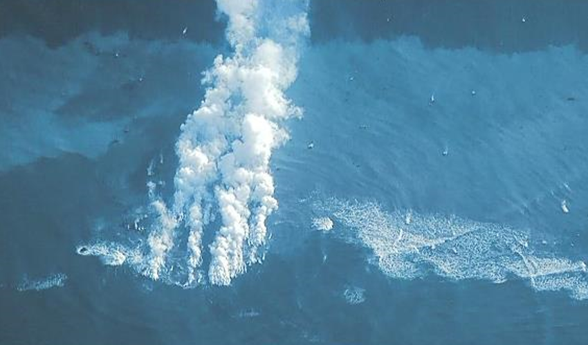
Japan , Iwo Jima ( Ioto) :
The Japan Coast Guard conducted an overflight of Ioto (Iwo-jima) on 13 February and observed no eruptive activity. A remnant part of the island remained that was about 25 m wide and 10 m high and in the shape of an arch. White fumarolic activity occurred at the S end of the island and hot water over the main vent area was observed. Eruptive activity in an area adjacent to the island was observed during an overflight on 16 March. A video posted with the report showed a roughly circular area of disturbed whitish water with several steaming rocks located around the margins. The report urged nearby ships to use caution in the area.
Ioto, in the Volcano Islands of Japan, lies within a 9-km-wide submarine caldera. The volcano is also known as Ogasawara-Iojima to distinguish it from several other « Sulfur Island » volcanoes in Japan. The triangular, low-elevation, 8-km-long island narrows toward its SW tip and has produced trachyandesitic and trachytic rocks that are more alkalic than those of other volcanoes in this arc. The island has undergone uplift for at least the past 700 years, accompanying resurgent doming of the caldera; a shoreline landed upon by Captain Cook’s surveying crew in 1779 is now 40 m above sea level. The Motoyama plateau on the NE half of the island consists of submarine tuffs overlain by coral deposits and forms the island’s high point. Many fumaroles are oriented along a NE-SW zone cutting through Motoyama. Numerous recorded phreatic eruptions, many from vents on the W and NW sides of the island, have accompanied the uplift.
Sources : Japan Coast Guard , GVP.
Photo :Japan Coast Guard
Colombia , Chiles / Cerro Negro :
Chiles Volcanic Complex / Cerro Negro (CVCCN) Weekly Activity Bulletin
Regarding the monitoring of the activity of the CHILES AND CERRO NEGRO VOLCANOES, the MINISTRY OF MINES AND ENERGY, through the COLOMBIAN GEOLOGICAL SERVICE (SGC), reports that:
During the period from March 12 to 18, seismic activity showed a decrease in its frequency and energy released compared to records from previous weeks. The predominance in terms of occurrence and energy of earthquakes associated with rock fracture continues, although the recording of events associated with the movement of fluids within volcanic conduits continues, some of between them with very low frequency content.

The fracture earthquakes were located in two groups: the first in the southern quadrant of the Chiles volcano, at distances less than 5 km, with depths between 2 and 7 km from its summit (4,700 m above sea level). ) and a maximum magnitude of 1.8. The other group of earthquakes was located towards the South-South-East, at distances between 7 and 9 km, with depths between 8 and 9 km from its summit (4,700 m above sea level). the sea) and a maximum magnitude of 1.6.
Volcanic deformation processes recorded by sensors installed on the ground and by remote satellite sensors continue.
The evolution of activity in the CVCCN is the result of internal processes derived from the complex interaction between the magmatic system, the hydrothermal system and the geological faults of the area. Thus, the probability of the occurrence of energetic earthquakes that could be felt by residents of the CVCCN zone of influence persists.
Volcanic activity remains on YELLOW ALERT Status: Active volcano with changes in baseline behavior of monitored parameters and other manifestations
Source : SGC
Photo : IGEPN
Hawaii , Kilauea :
Tuesday, March 19, 2024, 7:45 AM HST (Tuesday, March 19, 2024, 17:45 UTC)
19°25’16 » N 155°17’13 » W,
Summit Elevation 4091 ft (1247 m)
Current Volcano Alert Level: ADVISORY
Current Aviation Color Code: YELLOW
Activity Summary:
Kīlauea volcano is not erupting. Low-level seismicity continues beneath the summit and Southwest Rift Zone, while rates of ground deformation remain low.
Summit Observations:
Low levels of seismicity continue beneath Kīlauea’s summit. During the past week, the rate of earthquakes here saw a very slight increase over previous weeks, but daily earthquake counts remain well below those detected during the January–February intrusion or prior to recent summit eruptions. At this time, earthquake depths beneath the summit are 0.5–5 miles (1–8 kilometers) below the surface, and magnitudes are typically below M2.0.
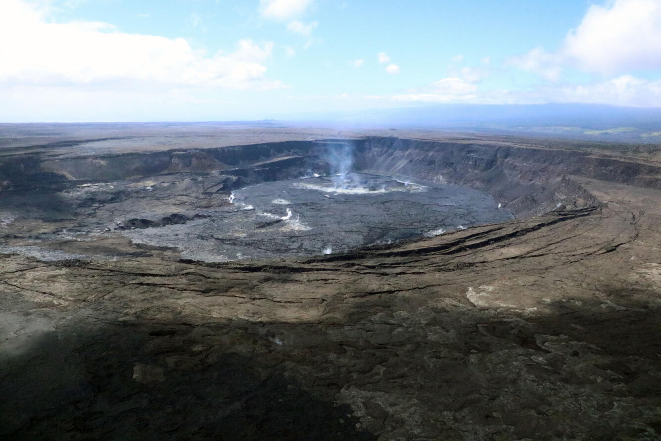
Ground deformation continues at low rates across Kīlauea, with tiltmeters near Uēkahuna and Sand Hill—respectively northwest and southwest of the summit caldera—showing only modest changes over the past week.
Sulfur dioxide (SO2) gas emissions have remained at low, noneruptive levels since October 2023. An SO2 emission rate of approximately 85 tonnes per day was recorded on March 1.
Rift Zone Observations:
Low levels of seismicity continue beneath Kīlauea’s Southwest Rift Zone. During the past week, the rate of earthquakes here saw a very slight increase over previous weeks, but daily earthquake counts remain well below those detected during the January–February intrusion. No unusual activity has been noted along the East Rift Zone. We continue to closely monitor both rift zones.
Measurements from continuous gas monitoring stations downwind of Puʻuʻōʻō in the middle East Rift Zone—the site of 1983–2018 eruptive activity—remain below detection limits for SO2, indicating that SO2 emissions Puʻuʻōʻō are negligible.
Source : HVO
Photo : USGS/ K. Mulliken
Solomon Islands , Tinakula :
A thermal anomaly extending from the summit of Tinakula down the W flank to the coast was identified in satellite images on 11 March. Images acquired on 6 and 16 March were cloudy or mostly cloudy.
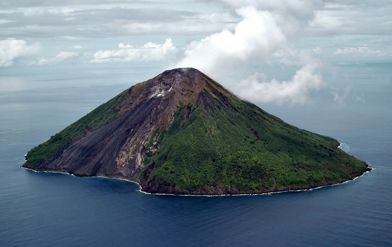
The small 3.5-km-wide island of Tinakula is the exposed summit of a massive stratovolcano at the NW end of the Santa Cruz islands. It has a breached summit crater that extends from the summit to below sea level. Landslides enlarged this scarp in 1965, creating an embayment on the NW coast. The Mendana cone is located on the SE side. The dominantly andesitic volcano has frequently been observed in eruption since the era of Spanish exploration began in 1595. In about 1840, an explosive eruption apparently produced pyroclastic flows that swept all sides of the island, killing its inhabitants. Recorded eruptions have frequently originated from a cone constructed within the large breached crater. These have left the upper flanks and the steep apron of lava flows and volcaniclastic debris within the breach unvegetated.
Sources : Copernicus , GVP.
Photo : Lance McC volcanohotspot