March 18 , 2024.
Iceland , Reykjanes Peninsula :
The Activity of the Eruption Has Decreased. Activity at three locations on the fissure.
Updated 17. March at 13:00 UTC
The volcanic eruption that began at 20:23 last night continues, but during the night the intensity of the eruption decreased, and now there are three active openings on the eruptive fissure. Seismic activity also significantly decreased overnight, with very few earthquakes measured after 3:00, coinciding with a decrease in volcanic tremor. This development is very similar to the three previous eruptions on the Sundhnúkur crater row.
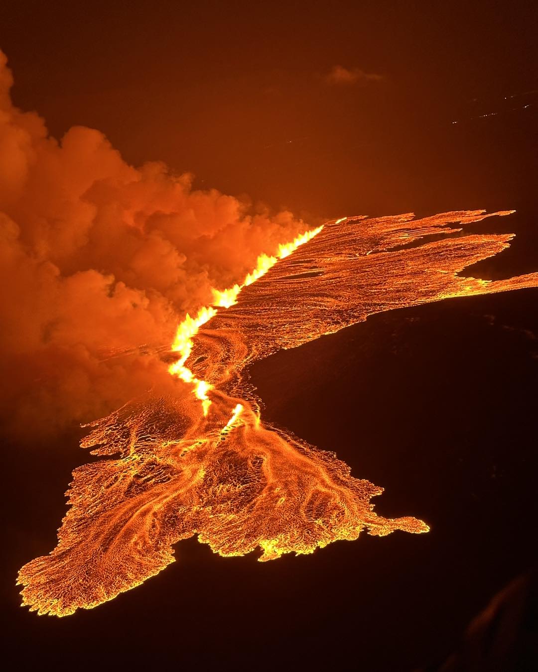
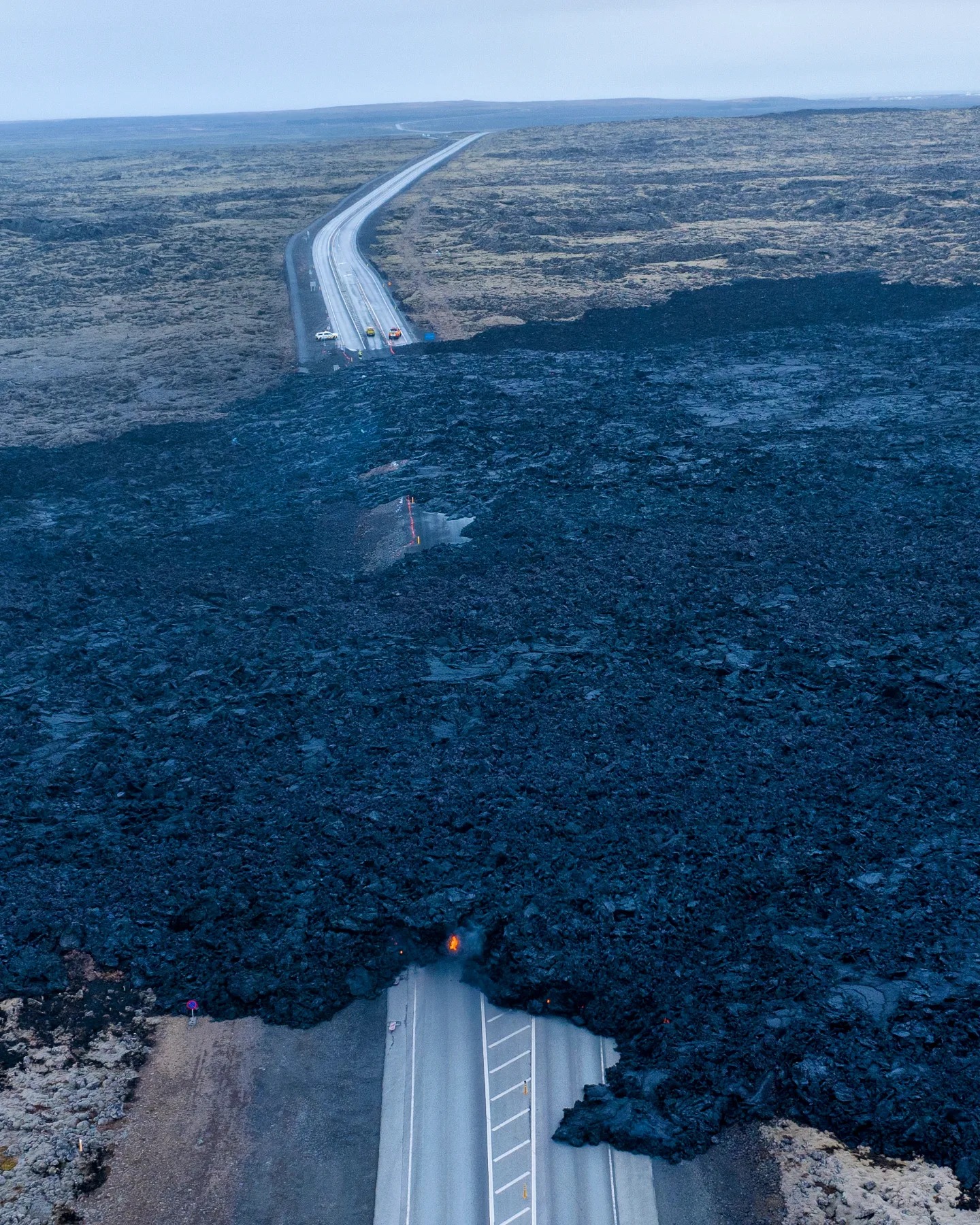
Shortly after midnight, lava flowed over the Grindavík road towards the water distribution pipe from Svartsengi power plant. There has been limited advancement in that lava flow front since this morning and it is now about 200 meters from the pipe. Another lava flow front runs alongside the protective barriers east of Grindavík and towards Suðurstrandarvegur road. Response workers in the area are monitoring the lava’s advance rate, which has been slow and steady since this morning.
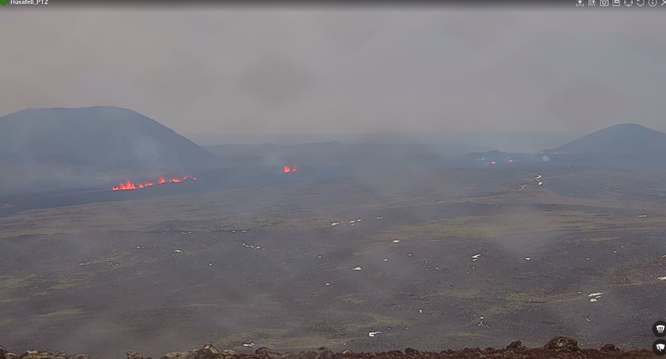
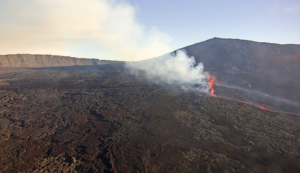
The eruption fissure as it was at 11:00 today. To the right of the image is Mt. Stóra-Skógafell, and to the left is Mt. Sýlingarfell. The most active part of the fissure is east of Sýlingarfell, with smaller openings to the north.
Today’s weather forecast is northeast winds of 8-13 m/s with intermittent rain, but the wind will gradually decrease. Gas emissions will mainly drift southwest from the eruption site. Tomorrow, southeast winds of 8-13 m/s are expected with showers, and the gas emissions will likely drift northwest. Temperatures generally range from 1 to 5 degrees Celsius near the eruption sites. There is considerable uncertainty regarding the intensity of gas emissions
Updated 17. March at 18:40 UTC
Since 04:00 UTC today, the propagation of lava has slowed substantially. However, the eruption has not ended, and lava continues to be extruded from a 0.5-km-long fissure, as confirmed by web camera and drone imagery. A lava front extends to the west from Sundhnúkur crater row. This front inundated Grindavíkurvegur in the early hours of Sunday morning at around 00:30 UTC, making the road impassable.
Lava also travelled southwards, and it is now less than 250 m from Suðurstrandarvegur – the main road on the southern coast of the Reykjanes Peninsula. Between 10:15 and 16:30 UTC today, this lava front moved at an average speed of 12 m per hour. Assuming the same speed of movement, it will take the front an additional ~20 hours to reach the main road. In the event of the lava reaching the road, an additional 350 m of propagation would be needed before lava could enter the sea.
Below is a map showing the impact area if the lava were to reach the sea. This scenario and response plans related to it have been discussed at status meetings of the Meteorological Office and Civil Protection yesterday and today.
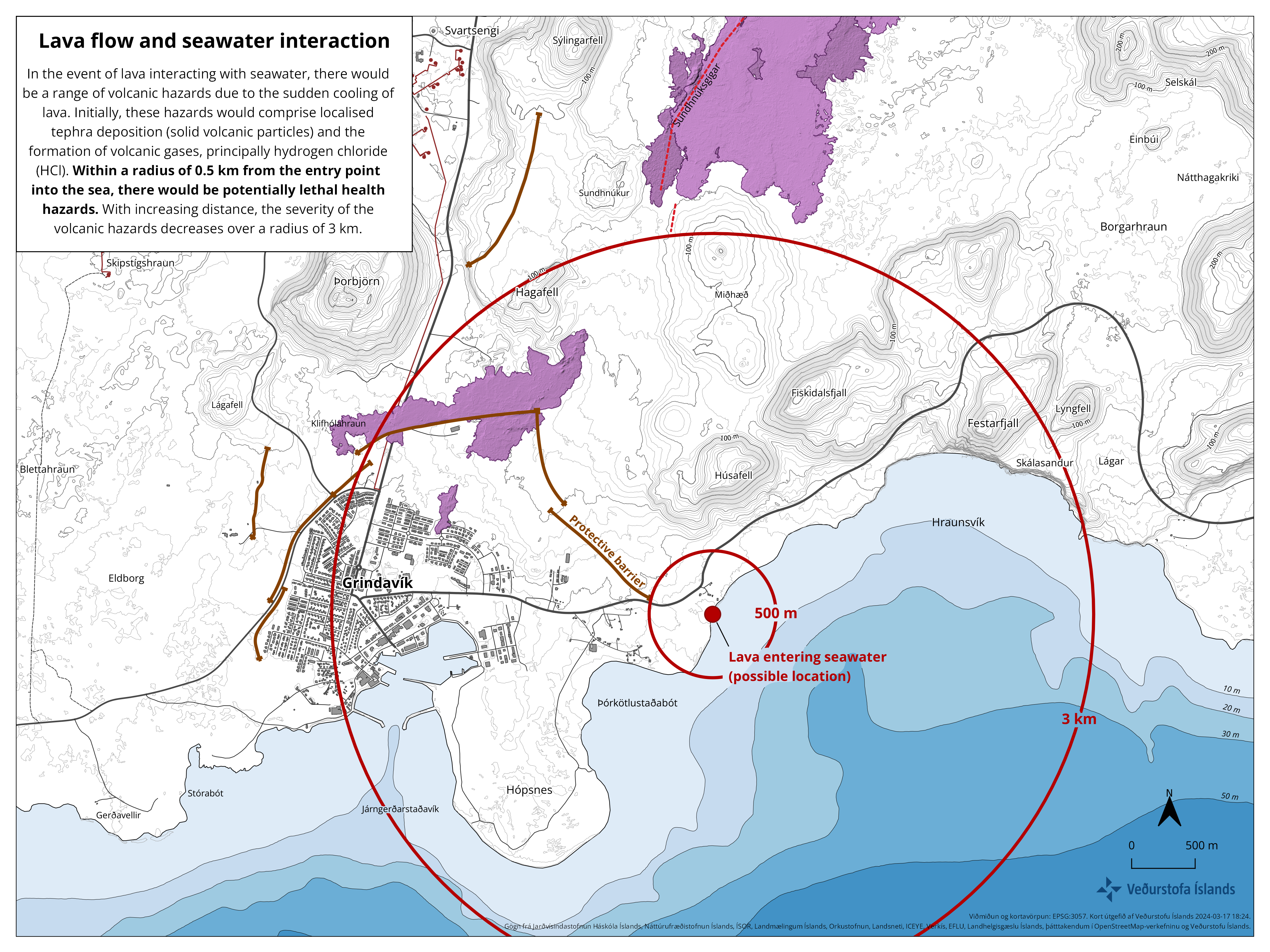
In the event of lava interacting with seawater, there would be a range of volcanic hazards due to the sudden cooling of lava. Initially, these hazards would comprise localised tephra deposition (solid volcanic particles) and the formation of volcanic gases, principally hydrogen chloride (HCl). Within a radius of 0.5 km from the entry point into the sea, there would be potentially lethal health hazards. With increasing distance, the severity of the volcanic hazards decreases over a radius of 3 km. Beyond that distance, health hazards due to gas pollution would be minor in nature.
Based on the development of the eruption today, our assessment is that lava flow into the sea is an unlikely scenario. However, until the eruption ends, and lava propagation stops entirely, it remains an outcome to consider for hazard assessment purposes. Assuming the same speed of movement (12 m per hour), it would take the southern lava front two days to reach the coastline.
Source : IMO.
Photos : Landhelgisgæsla Íslands/Icelandic Coast Guard, IMO , Jakob Vegerfors , IMO.
Indonesia , Dukono :
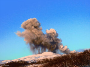
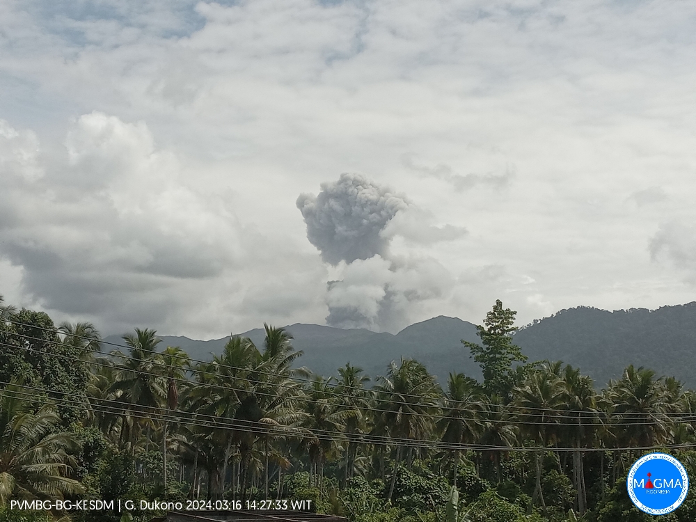
An eruption of Mount Dukono occurred on Saturday, March 16, 2024, at 4:25 p.m. WIT. The height of the eruptive column was observed to be ±1,500 m above the peak (±2,587 m above sea level). The ash column was observed to be white to gray in color with thick intensity, oriented towards the North. The eruption was recorded on a seismograph with a maximum amplitude of 7 mm and a duration of 75 seconds.
SEISMICITY OBSERVATIONS.
6 eruption/explosion earthquakes with an amplitude of 4 to 30 mm and earthquake duration of 35.96 to 69.73 seconds.
2 deep tectonic earthquakes with an amplitude of 7 mm, and earthquake duration 82.98-88.96 seconds.
1 Continuous tremor with an amplitude of 0.5 to 1 mm, dominant value of 1 mm.
RECOMMENDATION
(1) People around Mount Dukono and visitors/tourists are advised not to do activities, climb or approach Malupang Warirang Crater within a 3 km radius.
(2) Considering that eruptions with volcanic ash occur periodically and the distribution of ash follows the direction and speed of the wind, so that the landing area of the ash is not fixed, it is recommended that the community around Mount Dukono always provides masks/nose and mouth coverings to use when needed to avoid the threat of volcanic ash on the respiratory system.
Source et photo : Magma Indonésie.
Colombia , Cumbal :
Weekly activity bulletin from the Cumbal Volcanic Complex
Regarding the monitoring of the activity of the CUMBAL VOLCANIC COMPLEX (CVC), the MINISTRY OF MINES AND ENERGY, through the COLOMBIAN GEOLOGICAL SERVICE (SGC), reports that:
In the week from March 5 to 11 and compared to the previous period, seismic activity presented a slight increase in its occurrence and energy, with a predominance of events related to the fracture of rock material. The seismicity was mainly located near the La Plazuela crater located northeast of the Cumbal Volcanic Complex, at distances less than 1 km, depths less than 2 km compared to the height of La Plazuela (4,700 m above sea level). altitude) and a maximum magnitude of 1.1.
Gas emissions were recorded from the fumarole fields of El Verde to the northeast of the CVC, and Los Rastrojos and Boca Vieja, to the southwest of the CVC, with white columns, height and dispersion varying in depending on the wind direction. No significant variation was observed in the other geophysical and geochemical parameters of volcanic monitoring.
Volcanic activity remains on YELLOW ALERT Status: Active volcano with changes in baseline behavior of monitored parameters and other manifestations.
Source et photo : SGC
Peru , Sabancaya :
Analysis period: from March 4, 2024 to March 12, 2024, Arequipa, March 12, 2024
Alert level: ORANGE
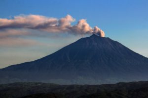
The Geophysical Institute of Peru (IGP) reports that the eruptive activity of the Sabancaya volcano remains at moderate levels, that is, with the recording of an average of 20 daily explosions, with columns of ash and of gas up to 2000 m altitude above the summit of the volcano. Consequently, the volcanic alert level remains at the ORANGE level
The IGP recorded and analyzed the occurrence of 272 earthquakes of volcanic origin, associated with the circulation of magmatic fluids inside the Sabancaya volcano, as well as earthquakes linked to the fracturing of rocks. An average of 20 explosions were recorded daily.
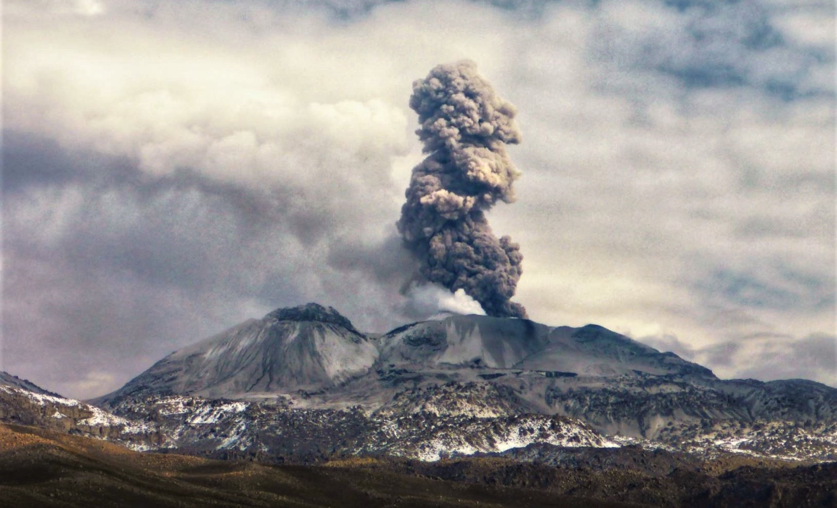
Columns of ash and gas have been observed at an altitude of up to 2000 m above the summit of the volcano. The predominant direction of these emissions was towards the South, North-West and South-West sectors of the volcano over a distance of less than 10 KM.
We continue to record a slight inflation process in the northern sector (around the Hualca Hualca volcano).
Satellite recordings identified the presence of 6 thermal anomalies, with a maximum value of 7 MW, associated with the presence of a lava body on the surface of the volcano crater.
Moderate emissions (2134 tonnes/day) of sulfur dioxide (SO2) were observed.
RECOMMENDATIONS
• Keep the volcano alert level in orange.
• Do not approach within a radius of less than 12 km from the crater.
Source : Cenvul
Photo : Andina
Costa Rica , Poas :
Latitude: 10.20°N;
Longitude: 84.23°W;
Altitude: 2687 m above sea level.
Current activity level: Warning
Possible manifestations: Small eruptions, bubbles or geysers, significant gas emission, increase in temperature (incandescence), seismic swarms or volcanic tremor,
slight inflation-extension of the volcanic edifice.
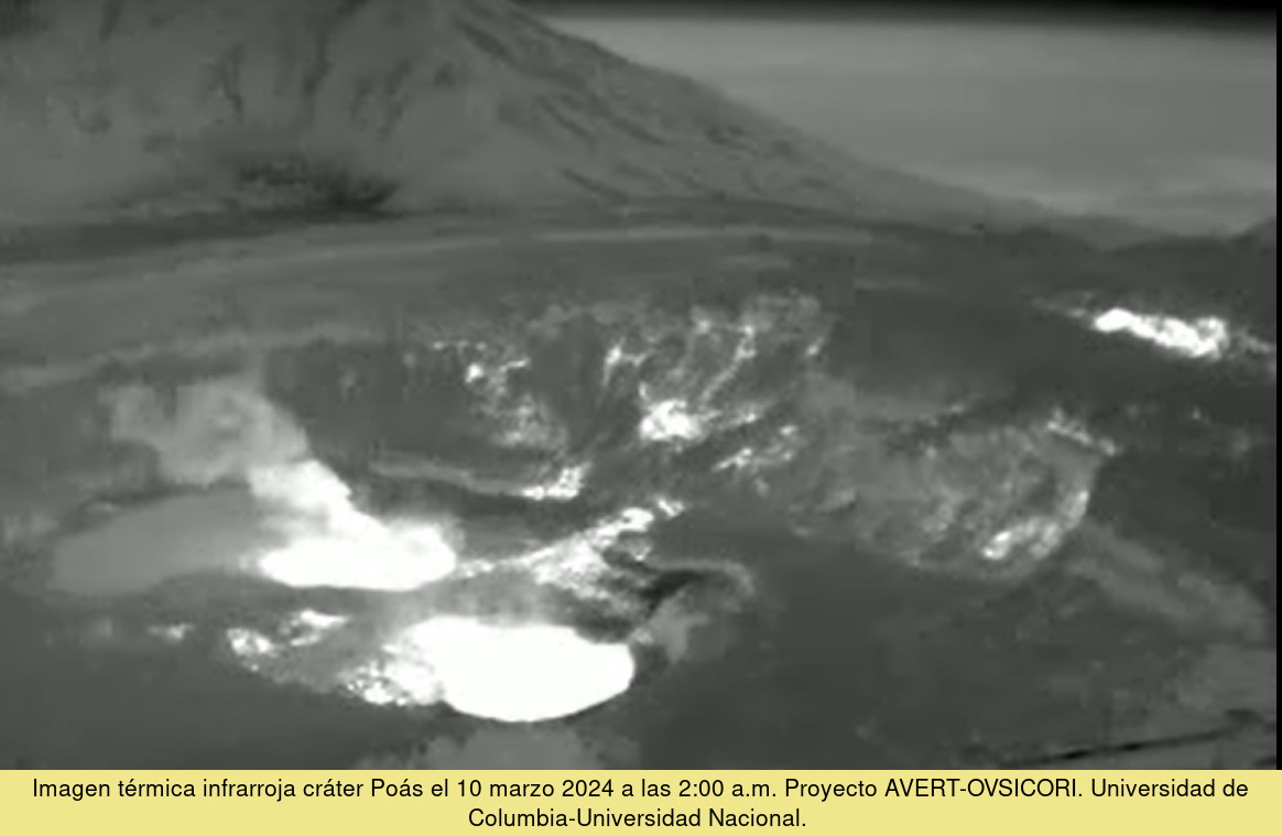
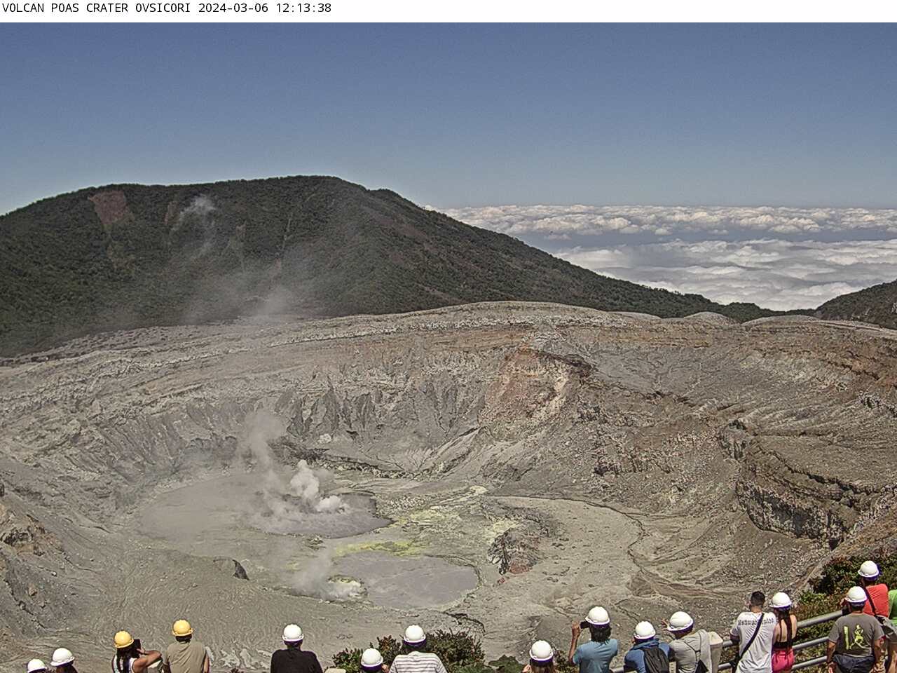
The seismic signal of volcanic tremor was maintained continuously with a moderate amplitude and in a frequency band between 0.8 and 7 Hz. Low frequency (LP) seismic events associated with the degassing of fumaroles and some small eruptions ( <50 Hz) were recorded. associated with small infrasound pulses. From around 9:00 a.m. on March 8, 2024, seismographs no longer recorded small phreatic eruptions in the hyperacid lake. Over the previous 4 days, starting on March 4, approximately 900 small phreatic eruptions (with a height of less than 50 m) were recorded using infrasound acoustic signals. The seismic signal of volcanic tremor of moderate amplitude is recorded with low frequencies between 0.8 and 3 Hz. The concentration of SO2 gas in the visitors’ viewpoint recorded maximum values of up to 3.6 parts per million similar to those of the previous week. Meanwhile, the MultiGAS gas monitoring system located on the western rim of the active crater recorded between 0.2 and 3 parts per million of SO2. The fumaroles continue to continuously degas directly into the atmosphere and flames due to the combustion of elemental sulfur are also observed at night in the southwest sector of the almost dry bottom of the hyperacid lake. On March 8, 2024, the SENTINEL satellite detected a mass of 56 tons of SO2 emitted by Poás, dispersing mainly to the north of the volcano. At the bottom of the active crater, only a few pools of gray muddy water remain in place of the hyperacid crater lake with its well-known turquoise green color. The GPS network continues to detect crustal contraction in the active sector of the crater.
Activity observed:
Over the past 24 hours, seismographs have recorded a continuous volcanic background tremor seismic signal with a dominant frequency band between 1 and 3 Hz and variable amplitude. Sporadic long-period seismic events (LP) linked to the movement of fluids in the volcano (water, gas) are also recorded. On the other hand, the gas ratios remained at normal values, H2S/SO2 around 0.24 and CO2/SO2 around 0.5, and SO2 between 5 and 20 ppm, according to the MultiGAS gas detection system located on the edge. West of the active Poas crater. The SO2 gas concentration at Visitor Viewpoint remained below 1 ppm this morning. The hyperacidic Poás Lake has been reduced to a few pools of hypersaline and hyperacidic water whose chemical composition is determined by processes of precipitation of salts such as gypsum and by the evaporation of water due to the heat flow of the interior of the volcano, the lack of rain, wind and solar radiation. The chemistry of the saline and acid basins indicates that a regime of hydrothermal activity dominates on the Poás.
Source et photos : Ovsicori.