March 17 , 2024.
Iceland , Reykjanes Peninsula :
Eruption has started between Mt. Hagafell and Mt. Stóra Skógfell . This is the fourth eruption on the Sundhnúksgíga crater row from the beginning of the unrest in October 2023
Updated 17. March at 01:25 UTC
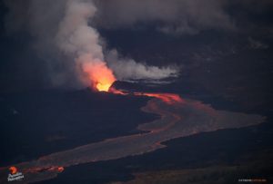
The Icelandic Met Office has updated the hazard map for the area. Lava flow continues to the south and southeast. The speed of the lava front is estimated to be 1 km/hr.
If the eruption continues at the same rate the scenario of lava reaching the ocean needs to be considered.
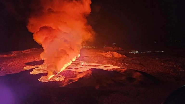
Now, about five hours into the eruption, the activity has been fairly constant for the whole length of the fissure.
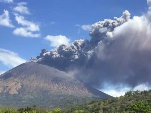
Updated 16. March at 23:50 UTC
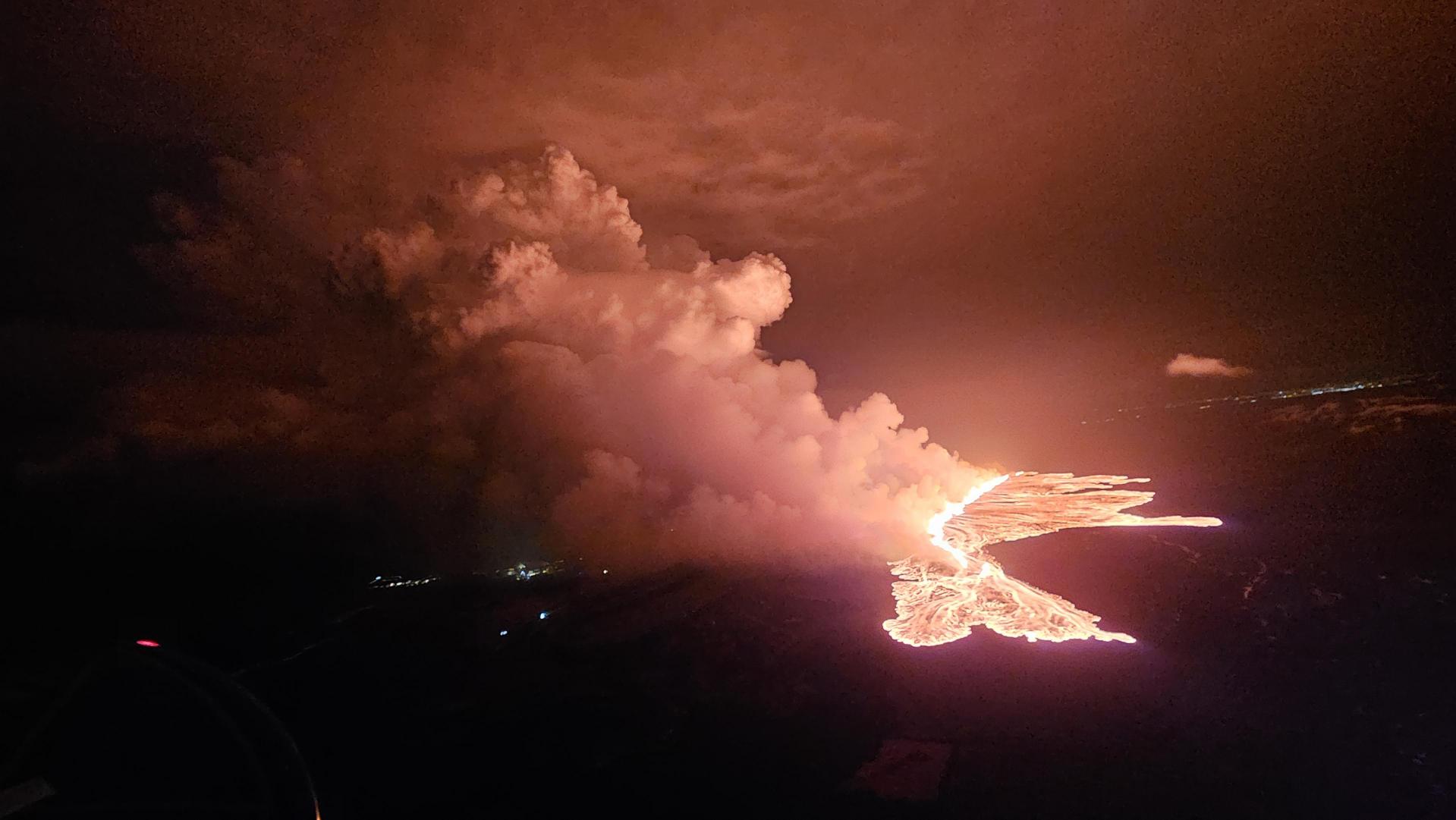
A volcanic eruption has begun between Mt. Hagafell and Mt. Stóra Skógfell. The eruption began at 20:23 UTC on 16 March, with a 2.9-km-long fissure forming quickly. The length and location of the fissure is similar to the eruption on 8 February 2024.
The pre-eruptive warning phase was very short. The first warning to the Department of Civil Protection and Emergency Management was at 19:43 UTC, and the onset of eruption was confirmed on web cameras just 40 minutes later. The eruption is effusive in nature, so the eruption plume consists mainly of steam and gas.
Picture showing the status of the eruption at 21:40.
The Icelandic Coast Guard performed a helicopter flight over the eruption area. The flight had experts from IMO, the University of Iceland, the Department of Civil Protection and Emergency Management. Lava is flowing westwards from the eruption fissure in the direction of Grindavíkurvegur (road) and the protection barriers for the Svartsengi region. Additionally, a large lobe of lava is flowing southeast, towards the protection barriers for Grindavík.
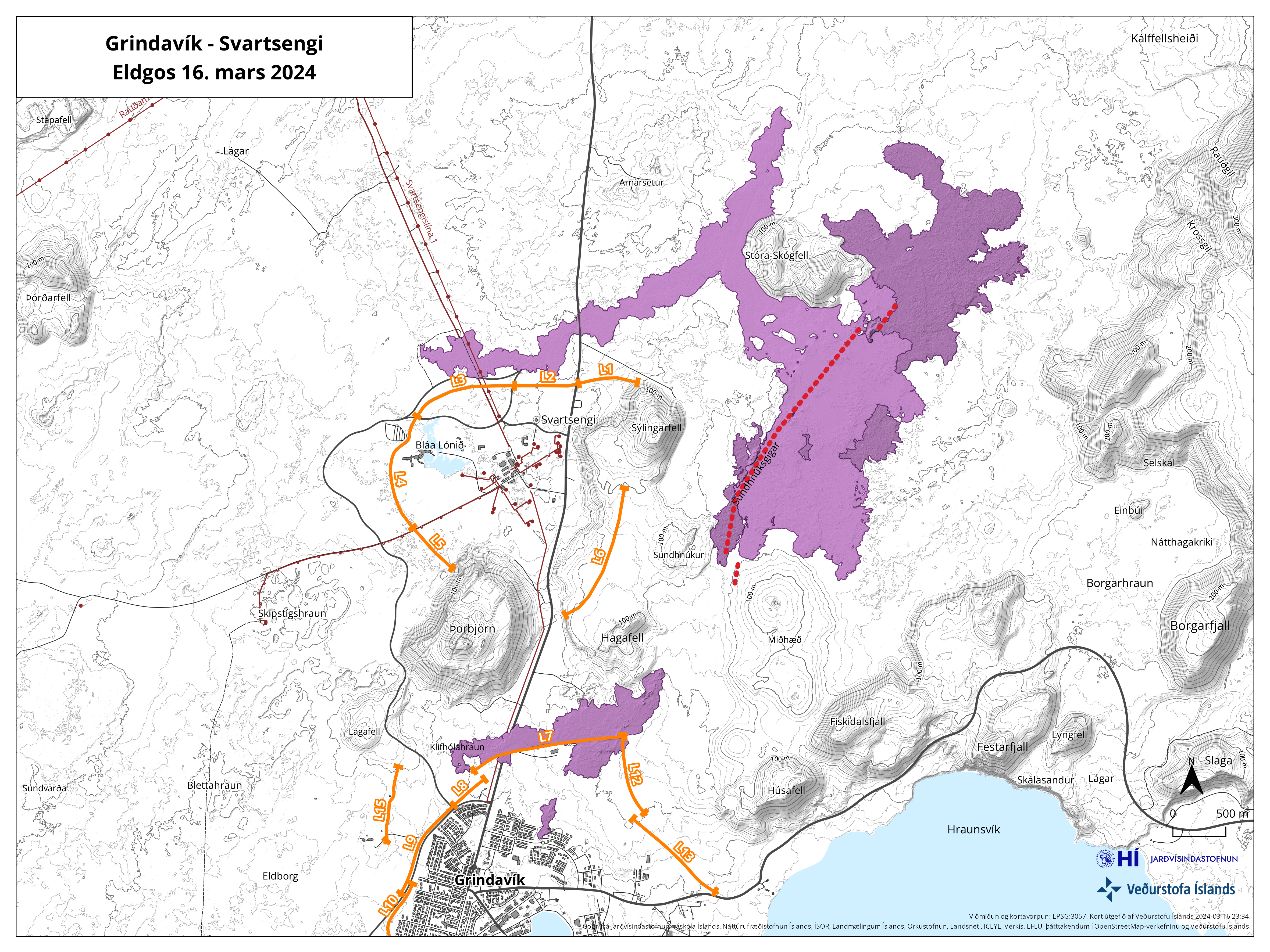
The map shows the fissure opening in red. Orange lines shows lava barriers.
From initial assessments of web camera imagery and aerial photographs from the helicopter flight, the eruption is thought to be the largest (in terms of magma discharge) of the three previous fissure eruptions from the Sundhnúkur crater row. This estimate applies to the first hour of eruptive activity.
At 22:10 UTC, the southern lava front was just 200 m from the barriers on the eastern side of Grindavík and moving at a rate of about 1 km per hour. At 22:20 UTC, lava was 700 to 800 m away from Grindavíkurvegur, nothwest of Grindavík, moving at a rate of approximately 1 km in 1.5 hours.
Source : IMO.
Photo : Veðurstofan / Safetravel FB , .DCPEM/Björn Oddsson , IMO.
Indonesia , Merapi :
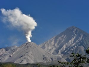
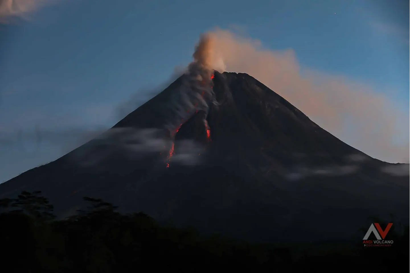
Mount Merapi Activity Report March 8-14, 2024. Published March 15, 2024
OBSERVATION RESULT
Visual
The weather around Mount Merapi is generally clear in the morning and night, while it is foggy from noon to evening. White smoke, fine to thick, low to moderate pressure and 150 m high was observed from the observation post of Mount Merapi Babadan on March 13, 2024 at 09:50 WIB. This week, lava avalanches were observed 91 times towards the South-West (upstream of the Bebeng River) up to a maximum of 1,800 m. The sound of an avalanche was heard once from Kaliurang post with low intensity. It was observed that the morphology of the southwest dome had changed due to the activity of hot cloud avalanches and lava avalanches. The morphology of the median dome is relatively constant. Based on the analysis of aerial photos from January 10, 2024, the volume of the southwest dome was measured at 2,663,300 m3 and that of the central dome at 2,358,400 m3.
Seismicity
This week, the seismicity of Mount Merapi recorded:
1 shallow volcanic earthquake (VTB),
13 multi-phase (MP) earthquakes,
380 avalanche earthquakes(RF),
6 tectonic earthquakes (TT).
The intensity of earthquakes this week is still quite high.
Deformation
The deformation of Mount Merapi monitored by EDM this week showed a shortening rate of 0.14 cm/day.
Rain and lahars
This week there was rain at Mount Merapi lookout post with a rain intensity of 52 mm/hour for 93 minutes at Kaliurang lookout post on March 14, 2024. No additional flow or lahar was reported in the rivers that have their source on Mount Merapi.
Conclusion
Based on the results of visual and instrumental observations, it was concluded that: The volcanic activity of Mount Merapi is still quite high in the form of effusive eruptive activity. The activity status is set to the “SIAGA” level
Source : BPPTKG
Photo : Andi Volcanist .
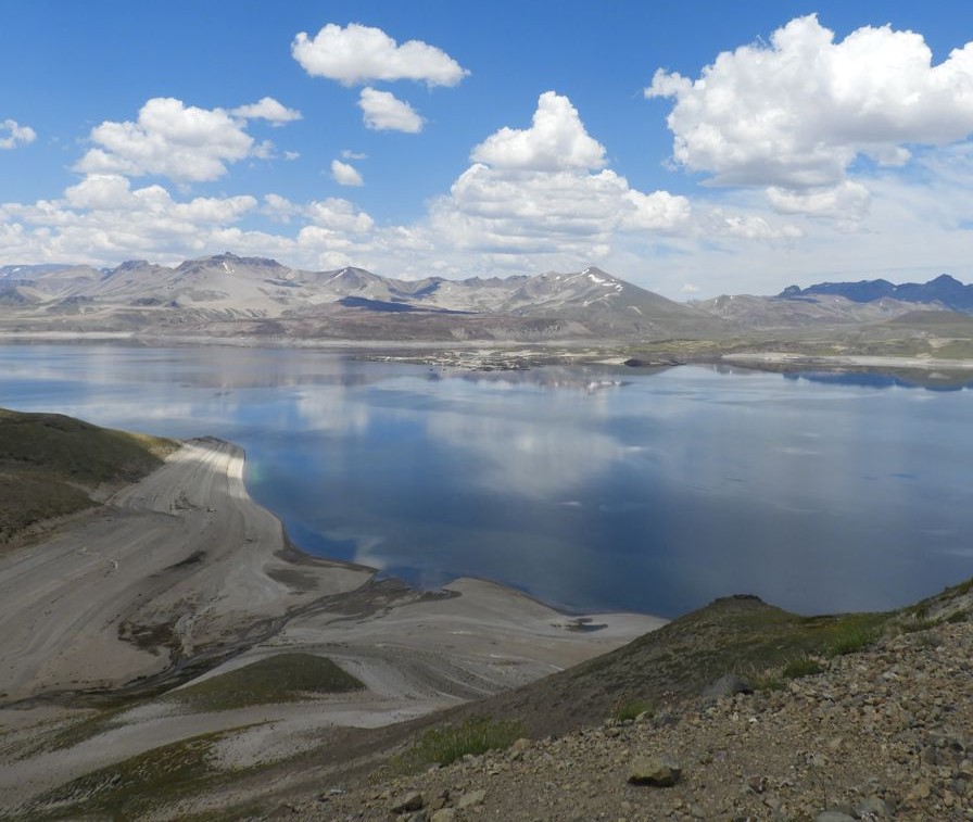
Chile , Laguna del Maule :
Special Report on Volcanic Activity (REAV), del Maule regions, Laguna del Maule volcanic complex, March 17, 2024, 02:50 local time (mainland Chile)
The National Geology and Mining Service of Chile (Sernageomin) announces the following PRELIMINARY information, obtained through the monitoring equipment of the National Volcanic Monitoring Network (RNVV), processed and analyzed at the Southern Andean Volcano Observatory (Ovdas):
On Sunday March 17, 2024, since 01:47 local time (04:47 UTC), monitoring stations installed near the Laguna del Maule volcanic complex recorded a low-energy seismic swarm associated with the fracturing of rocks (volcano-tectonic). At the time of issuing this report, 13 events were recorded. Localized events are concentrated around 7 km west-southwest of the center of the lagoon.
The characteristics of the largest earthquake after its analysis are as follows:
ORIGINAL TIME: 01:53 local time (04:53 UTC)
LATITUDE: 36.106°S
LONGITUDE: 70.577° W
DEPTH: 6.3 km
LOCAL MAGNITUDE: 0.2 (ML)
Observation :
At the time of issuing this report, the swarm of earthquakes continues, however it has decreased in frequency of occurrence of events.
The technical volcanic alert is maintained at YELLOW level.
Source et photo : Sernageomin
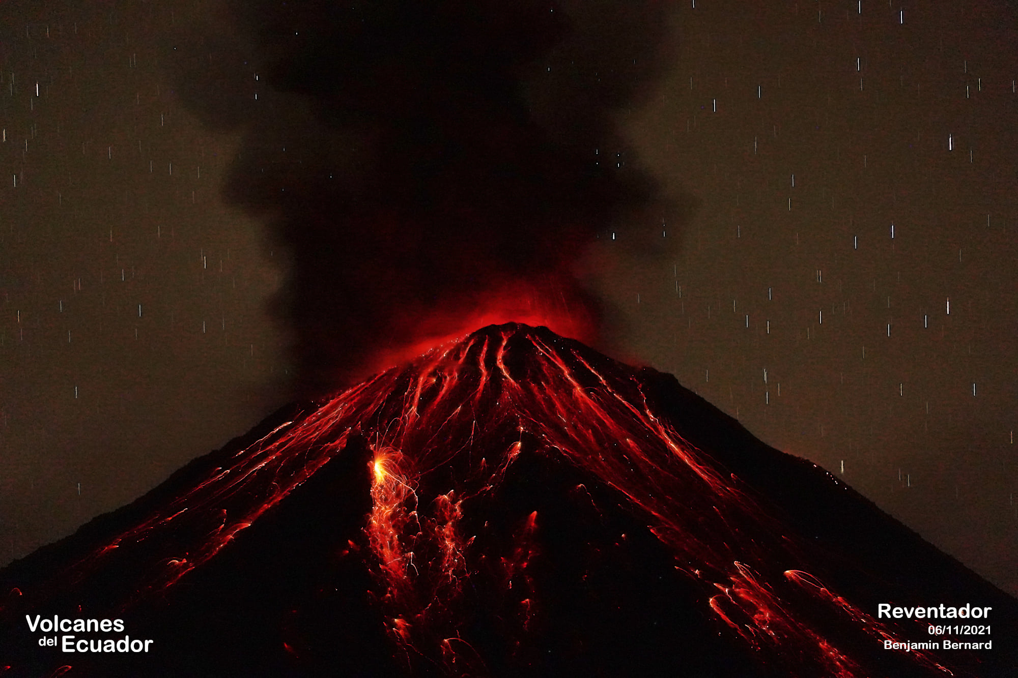
Ecuador , Reventador :
DAILY REPORT ON THE STATE OF REVENTADOR VOLCANO, Saturday March 16, 2024.
Information Geophysical Institute – EPN.
Surface activity level: Moderate, Surface trend: No changes
Internal activity level: Moderate, Internal trend: No changes
Seismicity: From March 15, 2024, 11:00 a.m. to March 16, 2024, 11:00 a.m.:
The following table shows the number of seismic events from the reference station in the last 24 hours.
Explosion (EXP) 47
Long Period (LP) 7
Transmitting tremor (TREMI) 8
Tremor harmonic (TRARM): 11
Precipitation/Lahars:
Light rains were recorded in the volcano area without generating mud or debris flows. **Heavy rains could remobilize accumulated material and generate mud and debris flows that travel down the volcano’s flanks and flow into rivers downstream.
Emissions/ash column:
Over the last 24 hours, thanks to the network of surveillance cameras, several emissions of gas and ash have been recorded with heights between 200 and 800 meters above the level of the crater, in the West-North-West directions. , West and South-West. Regarding these emissions, the Washington VAAC has published three emission reports with heights between 800 and 1,000 meters above the crater level, in the West, West-Northwest and Northwest directions.
Observation:
During last night, the descent of incandescent material along the flanks of the volcano was observed up to 900 meters below the level of the crater. At the time of closing this report, the volcano remained partially clear.
Alert level: Orange.
Source : IGEPN.
Photo : Benjamin Bernard ( archive).
Colombia , Galeras :
Galeras Volcano Weekly Activity Bulletin
Regarding the monitoring of the activity of the GALERAS VOLCANO, the MINISTRY OF MINES AND ENERGY, through the COLOMBIAN GEOLOGICAL SERVICE (SGC), reports that:
During the period from March 5 to 11, 2024, and compared to what was recorded the previous week, a decrease in seismic occurrence was observed, however, the level of energy released was maintained. The seismic activity of the volcano continues to be characterized by the predominance of events associated with rock fracture, followed by seismicity linked to fluid movements. For the most part, fracture events were located sparsely across the volcanic region, at distances less than 18 km from the main crater, with depths less than 14 km from the reference height (4,200 m above the sea level) and magnitudes less than 1.7.
Small gas emissions were recorded, mainly coming from the main crater and the fumarole fields “Las Chavas” and “El Paisita” (located respectively to the West and North of the crater), presenting white columns, low pressure output and variable dispersion due to wind action. In the other volcanic monitoring areas, stability was present.
Volcanic activity remains on YELLOW ALERT Status: Active volcano with changes in baseline behavior of monitored parameters and other manifestations.
Source and photo : SGC.