March 03 , 2024.
Iceland , Reykjanes Peninsula :
Indications That the Magma Intrusion Has Stopped. Too early to declare that there will be no eruption at this time
Updated 2. March at 19:10 UTC
At this point, the seismicity that began just before 16:00 UTC today has ceased. It is thus considered likely that the magma intrusion has stopped temporarily or is significantly diminished. However, minor deformation continues to be measured in the area, so it is too early to assert that the magma intrusion has ended, and that there will not be an eruption at this time. When magma intrusions occur, deformation can be measured for several hours after the seismic activity stops.
The Icelandic Meteorological Office continues to monitor the area to observe whether the activity resumes in the next few hours, or if the magma intrusion has halted completely. It remains possible that magma could ascend to the surface, as has been observed in eruptions near Fagradalsfjall.
Updated 2. March at 17:30 UTC
An intense swarm of microseismic activity is occurring east of Sýlingarfell on the Reykjanes Peninsula.
The seismicity indicates that magma movements have begun, and that a fissure eruption is likely.
The seismicity began at the southern end of the fissure that formed on 18 December 2023.
As of 17:30 UTC, it is apparent that the seismic activity has moved southwards in the direction of Hagafell.
Real-time, GPS-based measurements show much less signs of deformation than before previous eruptions since December 2023. This could signify that less magma is on the move than before the previous three eruptions on Sundhnúkur crater row.
At present, the depth of the seismicity does not indicate that magma is propagating to the surface.
As of 17:30 UTC, the likely scenario is that the magma intrusion will not necessarily lead to a volcanic eruption. However, while the situation remains uncertain, a imminent fissure eruption cannot be ruled out.
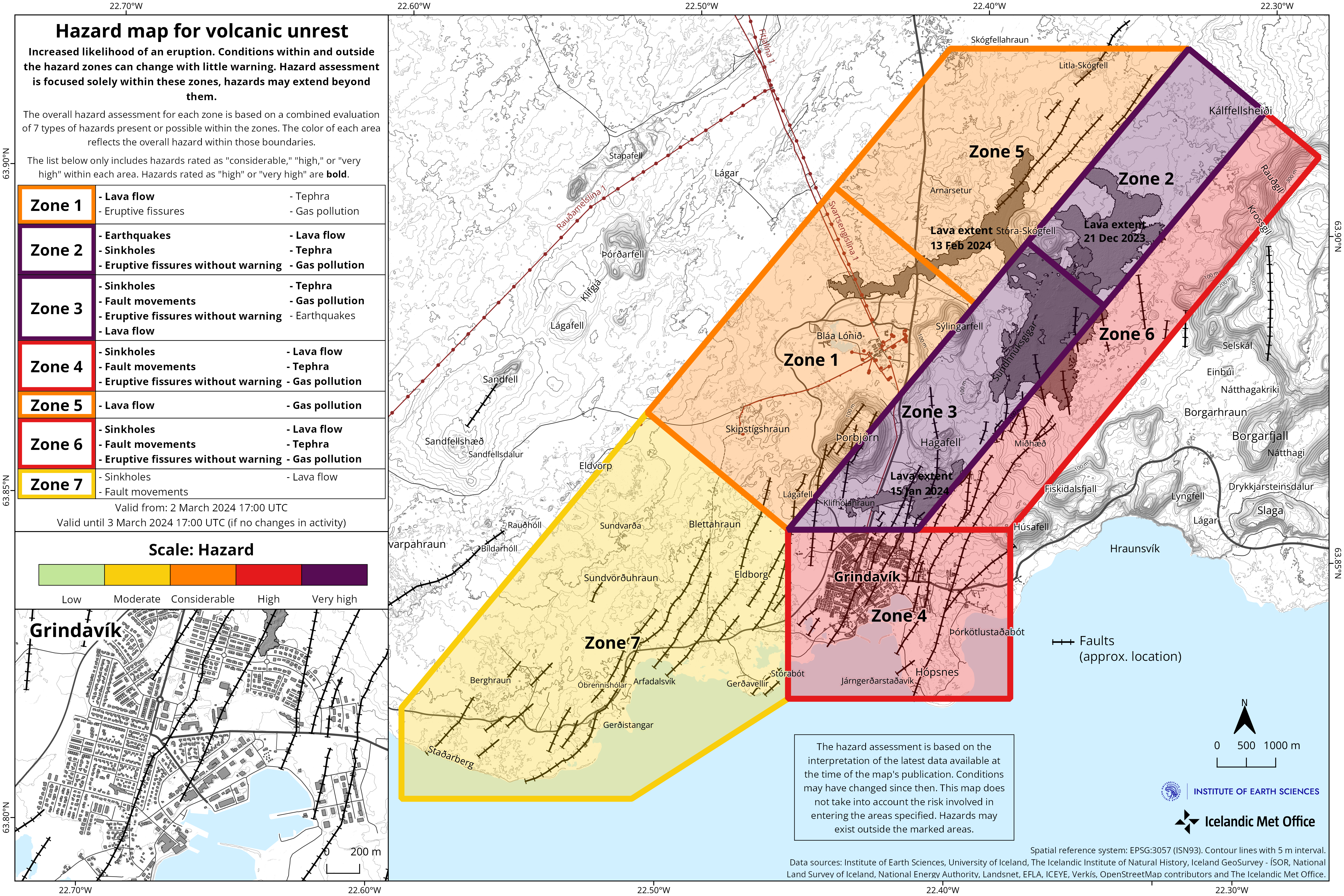
A new hazard assessment map from IMO was published today and is valid until tomorrow (3. March 2024) at 17:00 UTC.
Source et photo : IMO
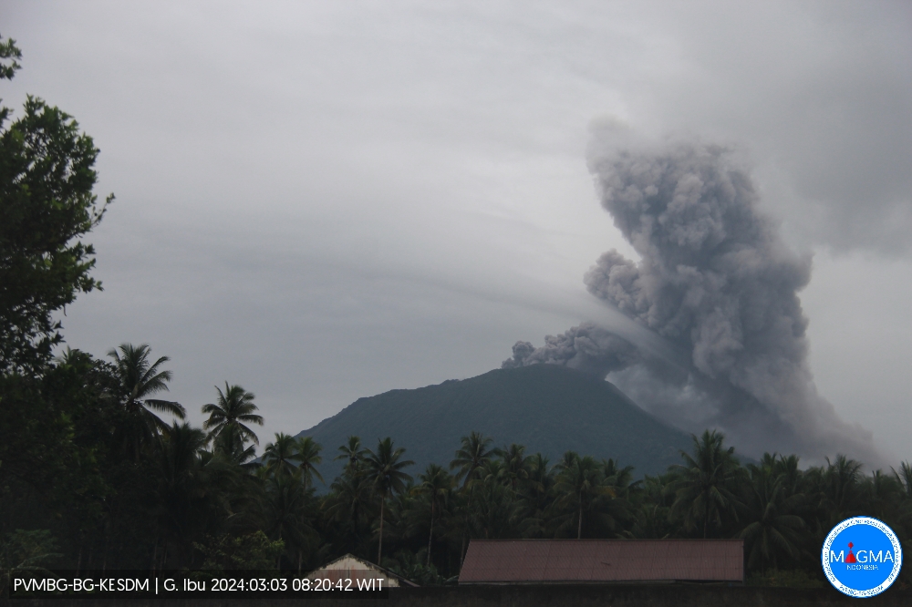
Indonesia , Ibu :
An eruption of Mount Ibu occurred on Sunday March 3, 2024 at 08:07 WIT with the height of the ash column observed at ±800 m above the summit (±2,125 m above sea level). The ash column was observed to be gray with thick intensity, oriented towards the South and South-West. This eruption was recorded on a seismograph with a maximum amplitude of 20 mm and a duration of 190 seconds.
SEISMICITY OBSERVATIONS:
10 eruption/explosion earthquakes with an amplitude of 15 to 28 mm and a duration of 23 to 132 seconds.
1 avalanche earthquake with an amplitude of 8 mm and an earthquake duration of 77 seconds.
126 emission earthquakes with an amplitude of 2 to 14 mm and earthquake duration of 15 to 50 seconds.
3 harmonic tremors with an amplitude of 3 to 8 mm and an earthquake duration of 129 to 482 seconds.
194 Shallow volcanic earthquakes with an amplitude of 2 to 14 mm and an earthquake duration of 4 to 14 seconds.
6 deep volcanic earthquakes with an amplitude of 5 to 10 mm, and an earthquake duration of 4 to 8 seconds.
7 distant tectonic earthquakes with an amplitude of 2 to 7 mm, and the duration of the earthquake was 44 to 108 seconds.
RECOMMENDATION
Communities around Mount Ibu and visitors/tourists are advised not to carry out activities within a radius of 2.0 km and a sectoral extension of 3.5 km towards the crater opening in the northern part of the crater active Mount Ibu.
In the event of ash falling, people who practice activities outside the home are advised to wear nasal, oral (mask) and eye (glasses) protection.
Source et photo : Magma Indonésie.
Colombia , Cumbal :
Weekly activity bulletin from the Cumbal Volcanic Complex.
Regarding the monitoring of the activity of the CUMBAL VOLCANIC COMPLEX (CVC), the MINISTRY OF MINES AND ENERGY, through the COLOMBIAN GEOLOGICAL SERVICE (SGC), reports that:
During the period from February 20 to 26, 2024 and compared to previous weeks, seismicity recorded a decrease both in terms of occurrence and energy released. Although the predominance of earthquakes linked to rock fracture has continued, earthquakes associated with the transit of fluids in the volcanic system have also occurred. The rock fracture earthquakes were located near the active La Plazuela crater of the Cumbal volcanic complex, at distances less than 2.7 km, depths up to 3.8 km compared to the height of La Plazuela (4700 m altitude) and a maximum magnitude of 0.5.
In addition, gas emissions were recorded from the El Verde fumarolic field, northeast of the Cumbal volcano, and from the Rastrojos y Bandas sector, in Mundo Nuevo. These emissions had white columns, low height and variable dispersion depending on wind direction. No significant variation was observed in the other geophysical and geochemical parameters of volcanic monitoring.
Volcanic activity remains on YELLOW ALERT Status: Active volcano with changes in baseline behavior of monitored parameters and other manifestations
Source et photo : SGC
Hawaii , Kilauea :
Saturday, March 2, 2024, 7:51 AM HST (Saturday, March 2, 2024, 17:51 UTC)
19°25’16 » N 155°17’13 » W,
Summit Elevation 4091 ft (1247 m)
Current Volcano Alert Level: ADVISORY
Current Aviation Color Code: YELLOW
Activity Summary:
Kīlauea volcano is not erupting. Low to moderate rates of seismicity at the summit and along the Koaʻe fault system southwest of the summit continues following an intrusion of magma into the area at the end of January.
Summit Observations:
Seismicity beneath the summit and extending 5-7 miles (8-11 km) southwest of the caldera under the Koaʻe fault zone continues. Earthquakes are dispersed widely from the summit to the southwest. There were 12 earthquakes recorded around the summit over the past 24 hours. Depths beneath the summit are 0.5-5 miles (1–8 km) below the surface, and magnitudes are typically below M2.0.
Ground deformation remains low with tiltmeters near Sand Hill showing modest changes in the past day.
Sulfur dioxide (SO2) gas emission rates have remained low since October 2023. An SO2 emission rate of approximately 117 tonnes per day was recorded on February 22.
Rift Zone Observations:
Seismicity in Kīlauea’s upper East Rift Zone and Southwest Rift Zone remain low. No unusual activity has been noted along the middle and lower sections of Kīlauea’s East Rift Zone. We continue to closely monitor both rift zones.
Source : HVO
Photo : USGS/ K. Mulliken.
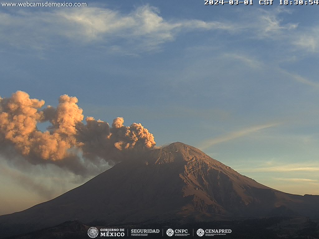
Mexico , Popocatepetl :
March 2, 11:00 a.m. (March 2, 5:00 p.m. GMT). Activity from the last 24 hours
28 exhalations were detected accompanied by water vapor, volcanic gases and ash. Additionally, 1,332 minutes of high-frequency, low-amplitude tremors (22.2 h) were identified. Today at 4:36 a.m., a magnitude 1.9 volcano-tectonic earthquake was recorded.
CENACOM (National Center for Communication and Civil Protection Operations) reported light ash falls in the central and southern municipalities of Tlaxcala; San Gregorio Atzompa, San Nicolas de los Ranchos, Juan C Bonilla, Nealtican, Tlaltenango, San Miguel Xoxtla, Santiago Xalitzintla, Puebla and Huejotzingo, Puebla. Hermanos Serdán International Airport will remain closed for a few hours due to ash sweeping from the landing strip.
We see that activity today is less than in 2023.
During the morning and at the time of this report, a continuous emission of volcanic gases and ash is observed, with dispersion towards the East (E).
The Popocatépetl volcanic warning fire is in yellow phase 2.
Source : Cenapred