February 17 , 2024.
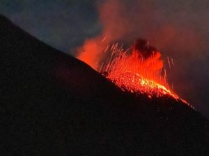
Alaska , Shishaldin :
No significant eruptive activity occurred over the past week. A minor ash plume was observed in a webcam image on February 11, which prompted AVO to raise the Aviation Color Code to ORANGE and Volcano Alert Level to WATCH. The low-level plume extended from the crater down the north flank and did not reach significant altitudes above the volcano summit. Additional analysis of various data streams shows no evidence of explosive activity associated with this event, and the low-level plume is likely the result of a small rock fall or debris flow mobilizing ash above the surface.

Seismicity remains elevated but unchanged throughout the week with ongoing volcanic earthquakes. Steaming, which is not uncommon for Shishaldin Volcano, was observed in satellite and webcam views on February 14 and 15. AVO detected no sulfur dioxide emissions, and no elevated surface temperatures were evident in satellite imagery.
No significant eruptive activity has been observed since November 2023.
Local seismic and infrasound sensors, web cameras, and a geodetic network are used to monitor Shishaldin Volcano. In addition to the local monitoring network, AVO uses nearby geophysical networks, regional infrasound and lighting data, and satellite images to monitor the volcano.
Source : AVO
Photo : Barnes, Chris
Iceland , Reykjanes Peninsula :
Magma accumulation beneath Svartsengi continues . Model calculations suggest magma accumulation will reach similar level as was noted prior to last eruption by the end of February or beginning of March
Updated 15. February at 16:00 UTC
Land uplift at Svartsengi area continues at similar trends and rates as has been detected following dyke propagations from there.
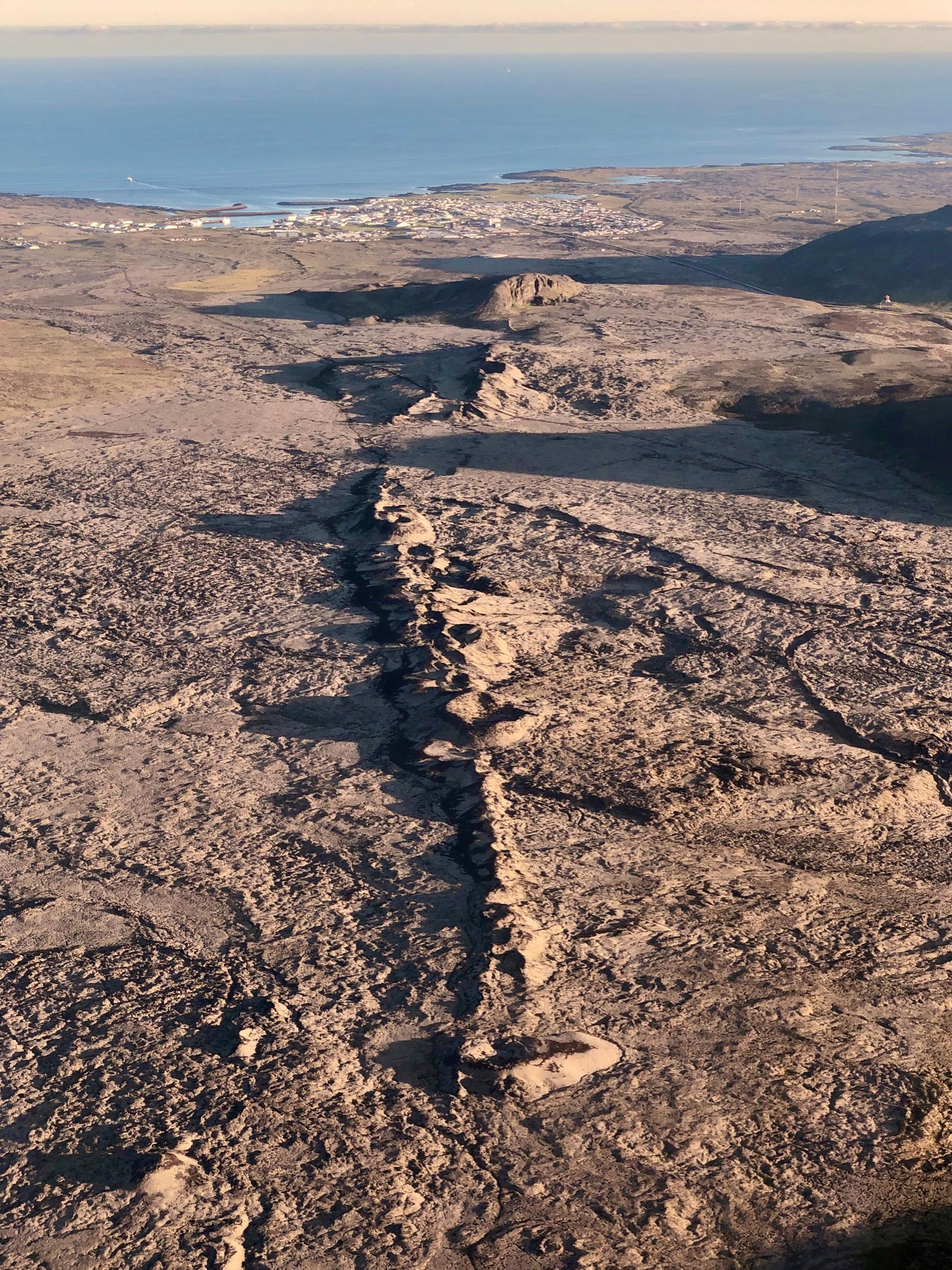
Model calculations based on GPS data suggest that magma accumulation from the end of the eruption 9th of February until yesterday, 14th of February, is about 2 million m3. It was estimated that when the eruption began on the 8th of February, about 10 million m3 of magma propagated from Svartsengi towards Sundhnúkur crater row. If magma accumulation continues at same rate, a total of 10 million m3 will be accumulated by the end of February or beginning of March, by which time likelihood of dyke propagation and volcanic eruption will increase significantly. These model calculations are based on GPS data but will be updated when new satellite data comes in.
Seismic activity in the western parts of mt. Fagradalsfjall continues with about 80 small earthquakes of magnitudes 1.5 or smaller detected since 12th of February. The depth of the earthquakes under the western part of mt. Fagradalsfjall is at 6-8 km. The area remains closely monitored but at the moment deformation data do not show signs of magma accumulation.
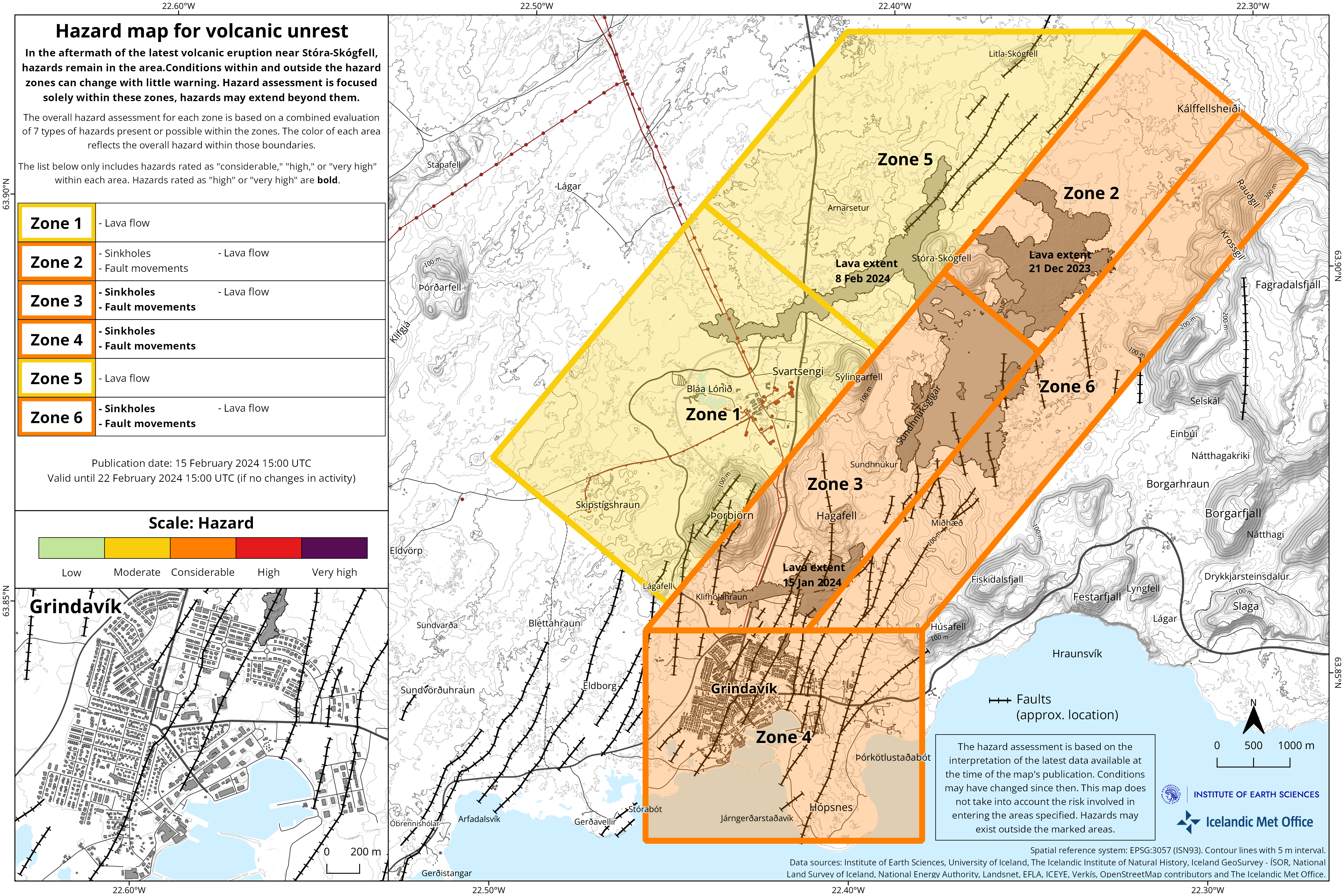
An updated hazard map has been published. It is valid until 22nd of February unless developments call for a re-evaluation. The main changes are that likelihood of eruptive vents opening has decreased in all Zones. Likelihood of sinkholes and fault movements are still considered high in Zone 4 (Grindavík). Please note that the hazard zones are active, and changes can occur with short notice. Furthermore, hazards can be present outside of the specified hazard zones, such as the faults that formed on the 10th of November 2023 west of Grindavík (see faults on map).
Source : IMO.
Photos : Siggi Anton , IMO.
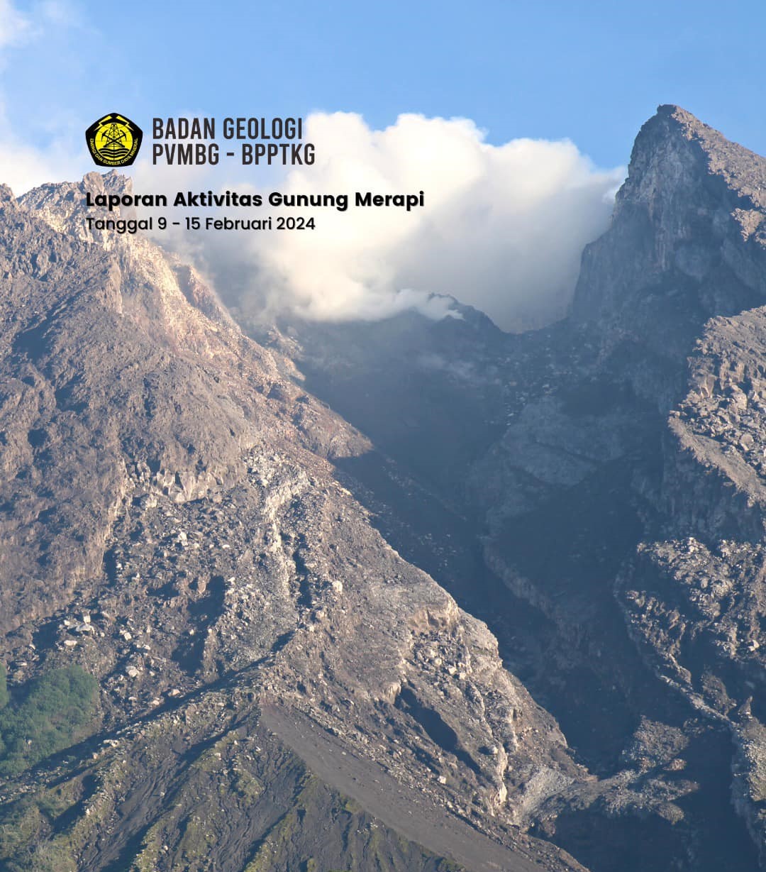
Indonesia , Merapi :
Mount Merapi activity report from February 9 to 15, 2024. Published on February 16, 2024.
Visual
The weather around Mount Merapi is usually sunny in the morning, while daytime until evening is foggy. White smoke, weak to thick, with low to moderate pressure and a height of 100 m is observed from the observation post of Mount Merapi of Pengamatan on February 10, 2024 at 05:50 WIB.
This week, 1 warm avalanche cloud descended towards the South-West (upstream of the Bebeng River) with a maximum sliding distance of 1500 m. Lava avalanches were observed 189 times in the South and Southwest, including 187 upstream of the Bebeng River for a maximum distance of 1,700 m and 2 towards the Boyong River for a maximum distance of 1,400 m. The sound of avalanches was heard twice from the Babadan post with low to moderate intensity.
It was observed that the morphology of the southwest dome had changed due to the activity of hot cloud avalanches and lava avalanches. Aerial thermal photos were taken by drone on February 15, 2024. The highest hot spot reached 254.3°C, lower than the previous measurement temperature. For the morphology of the median dome, no significant change was observed. The highest hotspot reached 22.9°C. Based on the analysis of aerial photos from January 10, 2024, the volume of the southwest dome was measured at 2,663,300 m3 and that of the central dome at 2,358,400 m3.
Seismicity
This week the seismicity of Mount Merapi recorded:
2 warm avalanche cloud (APG) earthquake,
22 shallow volcanic earthquakes (VTB),
181 multi-phase (MP) earthquakes,
719 emissions earthquakes(RF),
6 tectonic earthquakes (TT).
3 low frequency earthquake (LF).
The intensity of earthquakes this week is still quite high.
Deformation
The deformation of Mount Merapi monitored by EDM this week showed a shortening rate of 0.47 cm/day.
Rain and lahars
This week, there was rain with an intensity of 30 mm/hour for 65 minutes at the Ngepos station on February 12, 2024. It was reported that there had been no increase in flow in the rivers that originate on the Merapi.
Conclusion
Based on the results of visual and instrumental observations, it was concluded that:
Volcanic activity at Mount Merapi is still quite high in the form of effusive eruptive activity. The activity status is set to the “SIAGA” level.
Source et photo : BPPTKG
Colombia , Cumbal :
Weekly activity bulletin from the Cumbal Volcanic Complex
Regarding the monitoring of the activity of the CUMBAL VOLCANIC COMPLEX (CVC), the MINISTRY OF MINES AND ENERGY, through the COLOMBIAN GEOLOGICAL SERVICE (SGC), reports that:
Between February 6 and 12, 2024, with some fluctuations, seismicity maintained low levels of occurrence and daily energy, similar to those reported in previous weeks.
The earthquakes associated with rock fracturing were located near the two active cones of the complex (La Plazuela in the Northeast and Mundo Nuevo in the Southwest), at distances less than 1 km, with depths between 1 and 4 km from the height of La Plazuela (4700 m above sea level) and a maximum magnitude of 1.1.
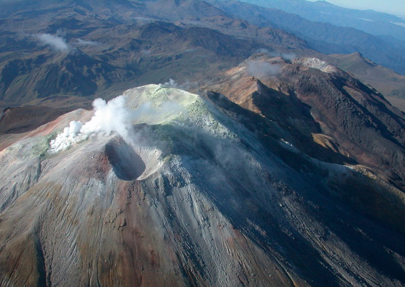
Gas emissions were recorded from the fumarole fields of El Verde to the northeast of the CVC, and Los Rastrojos and Las Bandas, to the southwest of the CVC, with white columns, low height and variable dispersion depending on the wind direction. No significant variation was observed in the other geophysical and geochemical parameters of volcanic monitoring.
Volcanic activity remains on YELLOW ALERT Status: Active volcano with changes in the behavior of the base level of monitored parameters and other manifestations.
Source et photo : SGC
Ecuador , Sangay :
DAILY REPORT ON THE STATE OF THE SANGAY VOLCANO, Friday February 16, 2024.
Information Geophysical Institute – EPN.
Surface activity level: High, Surface trend: Descending
Internal activity level: High, Internal trend: No change
Seismicity: From February 15, 2024, 11:00 a.m. to February 16, 2024, 11:00 a.m.:
The number of seismic events recorded at the reference station over the past 24 hours is shown below. The level of seismic activity of the volcano remains high.
Explosion Event (EXP): 29
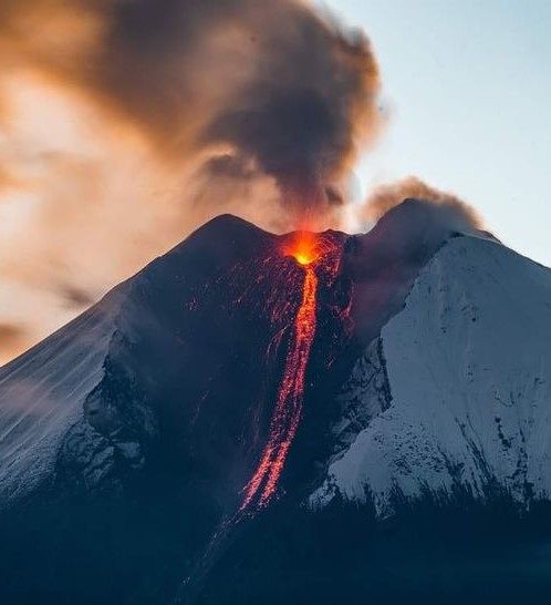
Precipitation/Lahars:
During this morning, thanks to the surveillance camera system, the existence of rain was reported in the area of the volcano and its surroundings without generating mudslides and debris. In the event of heavy rains, these could remobilize the accumulated materials, generating mud and debris flows which would descend the sides of the volcano and flow into adjacent rivers.
Emissions/ash column:
Due to the unfavorable weather conditions and zero visibility of the volcano, no gas and ash emissions were reported through monitoring of the surveillance camera system, while on satellite images, during the morning of Today, a continuous gas trail was observed in the West-South-West direction. W-VAAC has not published activity reports related to gas and ash emissions.
Other monitoring parameters:
During the last 24 hours, the FIRMS satellite system recorded 5 thermal anomalies, in turn the MIROVA-VIIRS system recorded 1 weak thermal anomaly.
Observation:
Since yesterday, thanks to surveillance cameras, it has been observed that the volcano remains completely cloudy and with zero visibility most of the time.
In contrast, during the night and early morning today, brief episodes of incandescent material descending 2000 meters below the level of the crater were observed across the southeastern ravine of the volcano.
Alert level: yellow
Source : IGEPN.
Photo : AlexBoasphoto